| This consolidation is unofficial and is for reference only. For the official version of the regulations, consult the original documents on file with the Registry of Regulations, or refer to the Royal Gazette Part II. |
| Regulations are amended frequently. Please check the list of Regulations by Act to see if there are any recent amendments to these regulations filed with our office that are not yet included in this consolidation. |
| Although every effort has been made to ensure the accuracy of this electronic version, the Registry of Regulations assumes no responsibility for any discrepancies that may have resulted from reformatting. |
| This electronic version is copyright © 2015, Province of Nova Scotia, all rights reserved. It is for your personal use and may not be copied for the purposes of resale in this or any other form. |
Battery Provincial Park Designation
made under Section 8 of the
Provincial Parks Act
R.S.N.S. 1989, c. 367
O.I.C. 72-338 (March 28, 1972), N.S. Reg. 117/72
O.I.C. 2014-346 (August 12, 2014), N.S. Reg. 121/2014
Order approved by O.I.C. 72-338
The Governor in Council on the report and recommendation of the Minister of Lands and Forests dated the 22nd day of March, A.D., 1972, pursuant to the provisions of Section 2 of Chapter 244 of the Revised Statutes of Nova Scotia, 1967, the Provincial Parks Act, is pleased to
(a) constitute all that area of land including land covered with water owned by Her Majesty in right of the Province of Nova Scotia and situate at St. Peters in the County of Richmond, Province of Nova Scotia, to be a Provincial Park, said area of land being included within the boundaries of the lands described in Schedule “A” attached to the report and recommendation and shown outlined on the Plan of Survey marked Schedule “B” also attached to the report and recommendation; and
(b) declare the name by which the park shall be known as “Battery Provincial Park”.
Schedule “A” to O.I.C. 72-338
Battery Provincial Park
All that certain lot, piece or parcel of land situate, lying and being at St. Peters, County of Richmond, Province of Nova Scotia, and shown on Plan Number E-5-5 on file at the Crown Land Records Office, Department of Lands and Forests, Halifax, Nova Scotia, and being more particularly described as follows:
Beginning at Crown Land iron post number R3377 set in concrete, situated on the southerly boundary of Highway No. 4 leading from St. Peters to Sydney;
From thence (by astronomic bearings) south sixteen degrees forty-nine minutes forty-five seconds west, five hundred sixty decimal thirty-four feet to Crown Land iron post number R3376;
Thence south seventy-three degrees ten minutes fifteen seconds east, three hundred fifty-four decimal eighty feet to the westerly boundary of a sixty-six foot right-of-way leading from the aforementioned Highway Number 4 to the Park lands;
Thence north nine degrees thirty-one minutes forty-five seconds west, one hundred eighty-five decimal forty-one feet along the aforementioned westerly boundary of the sixty-six foot right-of-way;
Thence continuing along the westerly boundary of said right-of-way north fifteen degrees forty-five minutes zero seconds east to the southerly boundary of aforementioned Highway Number 4;
Thence in a southeasterly direction along the southerly boundary of Highway Number 4 to Crown Land iron post number R3437;
Thence south fifteen degrees forty-five minutes zero seconds west, one hundred eighty-one decimal sixty-four feet along the easterly boundary of aforementioned right-of-way to Crown Land iron post number R3436;
Thence continuing along the easterly boundary of said right-of-way south nine degrees thirty-one minutes forty-five seconds east, two hundred three decimal thirty-two feet to Crown Land iron post number R3435;
Thence south seventy-three degrees ten minutes fifteen seconds east, one hundred twenty-two decimal twenty-three feet to Crown Land iron post number R3375;
Thence south thirteen degrees twenty-eight minutes forty-five seconds west, one thousand three hundred seventy-eight decimal zero eight feet to Crown Land iron post number R3374;
Thence south seventy-six degrees thirty-one minutes fifteen seconds east, one hundred thirty-three decimal seventy-five feet to Crown Land iron post number R3373;
Thence south thirteen degrees twenty-eight minutes forty-five seconds west, one thousand five hundred forty-eight decimal forty-two feet to Crown Land iron post number R3372;
Thence continuing south thirteen degrees twenty-eight minutes forty-five seconds west, one hundred decimal zero feet to a point on the waters of St. Peters Bay;
Thence north seventy-six degrees thirty-one minutes fifteen seconds west, one thousand nine hundred seventy decimal zero feet;
Thence north thirteen degrees twenty-eight minutes forty-five seconds east, one thousand seventy-five decimal zero feet;
Thence north seventy-five degrees one minute thirty-nine seconds east, nine hundred forty-three decimal sixty-seven feet to an iron post situated on the mean high water line of St. Peters Bay;
Thence following the mean high water line of St. Peters Bay in a generally northerly direction four hundred ninety feet more or less to a point being eighty feet east of the easterly edge of St. Peters Canal;
Thence continuing in a northerly direction, and maintaining a distance of eighty feet easterly and parallel to the easterly edge of St. Peters Canal, one thousand six hundred ninety feet more or less;
Thence south seventy-three degrees twenty-two minutes east, seventy-five feet more or less to a post and stones;
Thence north sixteen degrees thirty-eight minutes east, two hundred ninety-one decimal fifty-nine feet to an iron post said post marking the intersection of the easterly limit of St. Peters Canal reserve land with the southerly boundary of Highway Number 4;
Thence in a southeasterly direction along the aforementioned southerly boundary of Highway Number 4 to the place of beginning containing ninety-three acres more or less not including any land covered by the waters of St. Peters Bay;
Excepting thereout and therefrom an area of land upon which is presently erected a lighthouse known as the Jerome Point Lighthouse, the said area comprising one hundred square feet more or less;
And reserving in over, along and upon the said parcel, rights-of-way along the established foot-paths shown as dotted lines on aforementioned plan E-5-5 for the use and benefit of the Government of Canada;
Also reserving in, over and upon the said parcel, the right, for use in the buildings of the Government of Canada located on the west side of the Canal, to draw water from the spring as shown on plan E-5-5 and indicated by the word “spring”; that parcel or portion of the above
described land formerly controlled and administered by the Government of Canada is subject to the following condition that if required at any time by the Government of Canada for the expansion or reconstruction of the Canal, the Government of the Province of Nova Scotia will transfer to the Government of Canada all its rights of administration and control in respect of the said parcel.
Excepting and reserving therefrom any grants or easements of right-of-way in connection with power transmission lines or any other public utility over the above described land.
Schedule “B” to O.I.C. 72-338
[Note: The map referred to as Schedule “B” was not filed with the Office of the Registrar of Regulations.]
Order approved by O.I.C. 2014-346
The Governor in Council on the report and recommendation of the Minister of Natural Resources dated July 23, 2014, and pursuant to Section 8 of Chapter 367 of the Revised Statutes of Nova Scotia, 1989, the Provincial Parks Act, is pleased, effective on and after August 12, 2014, to
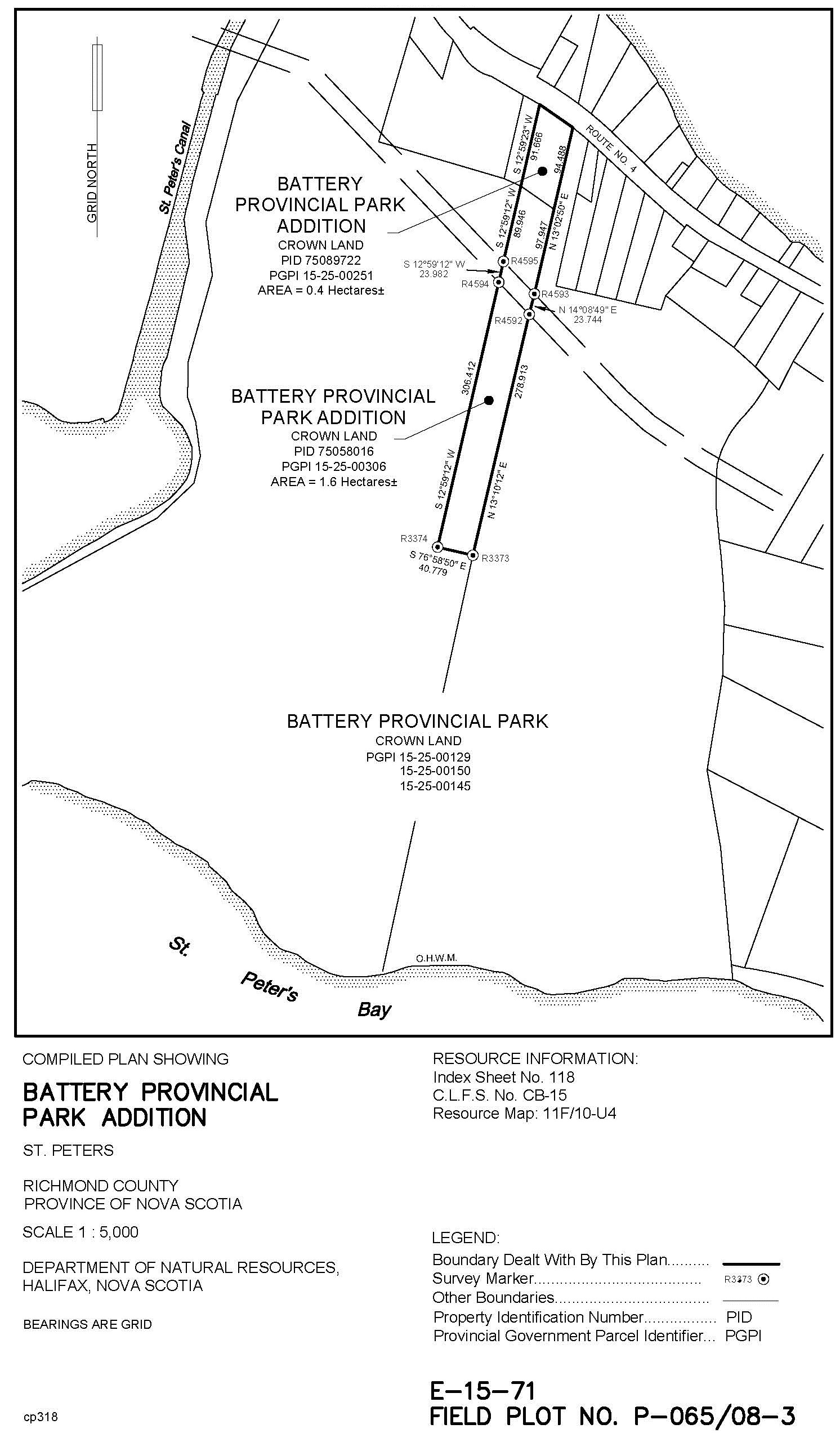
(a) increase the size of Battery Provincial Park, originally designated by the Governor in Council by Order in Council 72-338 dated March 28, 1972, by adding to it the lands shown outlined in bold on the plan marked Schedule “A” attached to and forming part of the report and recommendation; and
(b) [Clause (b) not regulations within the meaning of the Regulations Act.]
Schedule “A” to O.I.C. 2014-346
Last updated: 10-12-2017