| This consolidation is unofficial and is for reference only. For the official version of the regulations, consult the original documents on file with the Office of the Registrar of Regulations, or refer to the Royal Gazette Part II. |
| Regulations are amended frequently. Please check the list of Regulations by Act to see if there are any recent amendments to these regulations filed with our office that are not yet included in this consolidation. |
| Although every effort has been made to ensure the accuracy of this electronic version, the Office of the Registrar of Regulations assumes no responsibility for any discrepancies that may have resulted from reformatting. |
| This electronic version is copyright © , Province of Nova Scotia, all rights reserved. It is for your personal use and may not be copied for the purposes of resale in this or any other form. |
Crystal Crescent Provincial Park Designation
O.I.C. 81-1336 (effective November 3, 1981), N.S. Reg. 150/1981
amended to O.I.C. 2019-257 (effective September 30, 2019), N.S. Reg. 144/2019
Table of Contents
Please note: this table of contents is provided for convenience of reference and does not form part of the regulations.
Click here to go to the text of the regulations.
The Governor in Council, on the report and recommendation of the Minister of Lands and Forests dated the 14th day of October, A.D., 1981, and pursuant to the Provincial Parks Act, Revised Statutes of Nova Scotia, 1967, Chapter 244, Section 2, is pleased to:
(a) constitute all that area of land situate at Pennant, in the County of Halifax, owned by Her Majesty in the right of the Province of Nova Scotia, to be a Provincial Park, the said area of land being described in Schedule “A” and shown outlined in red on the copy of Crown Land Records Plan No. E-13-20 marked Schedule “B”, both Schedules attached to and forming part of the report and recommendation; and
(b) declare that the park shall be known by the name of “Crystal Crescent Provincial Park”.
All that certain lot, piece or parcel of land situate, lying and being at Pennant, in the County of Halifax, Province of Nova Scotia as shown outlined in red on the copy of Crown Land Records Plan No. E-13-20 marked Schedule “B” attached hereto, the said parcel of land being more particularly described as follows:
Beginning where the eastern boundary of the public highway (Coote Cove Road) intersects the southeastern boundary of the public highway leading to Sambro;
From thence northeasterly along the southeastern boundary of the public highway leading to Sambro, 129' more or less to a point on the southern boundary of the public highway leading to Cook Point;
Thence easterly along the southern boundary of the public highway leading to Cook Point, 920' more or less to the western boundary of E.L.T. Bloodworth subdivision;
Thence southerly along the western boundary of E.L.T. Bloodworth subdivision, 387' more or less to a corner thereof;
Thence easterly along the southern boundary of E.L.T. Bloodworth subdivision, 1517' more or less to a corner thereof;
Thence northerly 662' more or less along the eastern boundary of E.L.T. Bloodworth subdivision and crossing the public highway leading to Cook Point to a point;
Thence southerly crossing the public highway leading to Cook Point and along the western boundary of lands now or formerly of Mark L Nickerson, 2427' more or less to the ordinary high water mark of Coote Cove;
Thence southerly along the ordinary high water mark of Coote Cove, 1550' more or less to the northern boundary of ungranted land;
Thence westerly along the northern boundary of ungranted land, 1117' more or less to the eastern boundary of Coote Cove Road;
Thence southerly along the eastern boundary of the Coote Cove Road, 1700' more or less to the southern boundary of ungranted land;
Thence easterly and northerly along the southern and eastern boundaries of ungranted land, 1430' more or less to the ordinary highwater mark of Coote Cove;
Thence easterly and southerly along the ordinary high water mark of Coote Cove and Sambro Harbour, 17,000' more or less to Pennant Point;
Thence northerly along the ordinary high water mark of Pennant Harbour, 7,200' more or less to the southern boundary of lands now or formerly of Lawrence Keating;
Thence easterly along the southern boundary of lands now or formerly of Lawrence Keating, 1,320' more or less to a corner thereof;
Thence northerly along the eastern boundary of lands now or formerly of Lawrence Keating, 1,320' more or less to a corner thereof;
Thence westerly along the northern boundary of lands now or formerly of Lawrence Keating, 1,320' more or less to the ordinary high water mark of Pennant Harbour;
Thence northerly along the ordinary high water mark of Pennant Harbour, 4,200' more or less to the southern boundary of lands now or formerly of E. L. T. Bloodworth;
Thence easterly along the southern boundary of lands now or formerly of E. L. T. Bloodworth, 488' more or less to a corner thereof;
Thence northerly along the eastern boundary of lands now or formerly of E. L. T. Bloodworth, 1,495' more or less to the southern boundary of lands now or formerly of Harry Nickerson;
Thence northerly along the eastern boundary of lands now or formerly of Harry Nickerson, 283' more or less to the southern boundary of the public highway leading to Sambro;
Thence easterly along the southern boundary of the public highway leading to Sambro, 200' more or less to the western boundary of lands now or formerly of John L. Billard;
Thence southerly along the western boundary of lands now or formerly of John L. Billard, 702' more or less to a corner thereof;
Thence easterly 2,556' more or less along the southern boundaries of lands now or formerly of John L. Billard and lands now or formerly of Patrick V. Keenan and lands now or formerly of William Nickerson and then crossing the public highway (Coote Cove Road) to a point on the eastern boundary of the Coote Cove Road;
Thence northerly along the eastern boundary of the Coote Cove Road, 3,506' more or less to the place of beginning.
Exception and reserving therefrom lands now or formerly of Roy W. Harnish as described in Book 1686, at Page 946, said lands being Crown Grant 21196 containing 10 acres more or less;
Also excepting and reserving any portion of the public road leading to Cooks Point that passes through the above described lands.
The above described parcel of land contains 1,230 acres more or less.
[Note: The map referred to as Schedule “B” was not filed with the Office of the Registrar of Regulations.]
The Governor in Council on the report and recommendation of the Minister of Lands and Forestry dated August 8, 2018, and pursuant to Section 8 of Chapter 367 of the Revised Statutes of Nova Scotia, 1989, the Provincial Parks Act, is pleased, effective on and after September 30, 2019, to
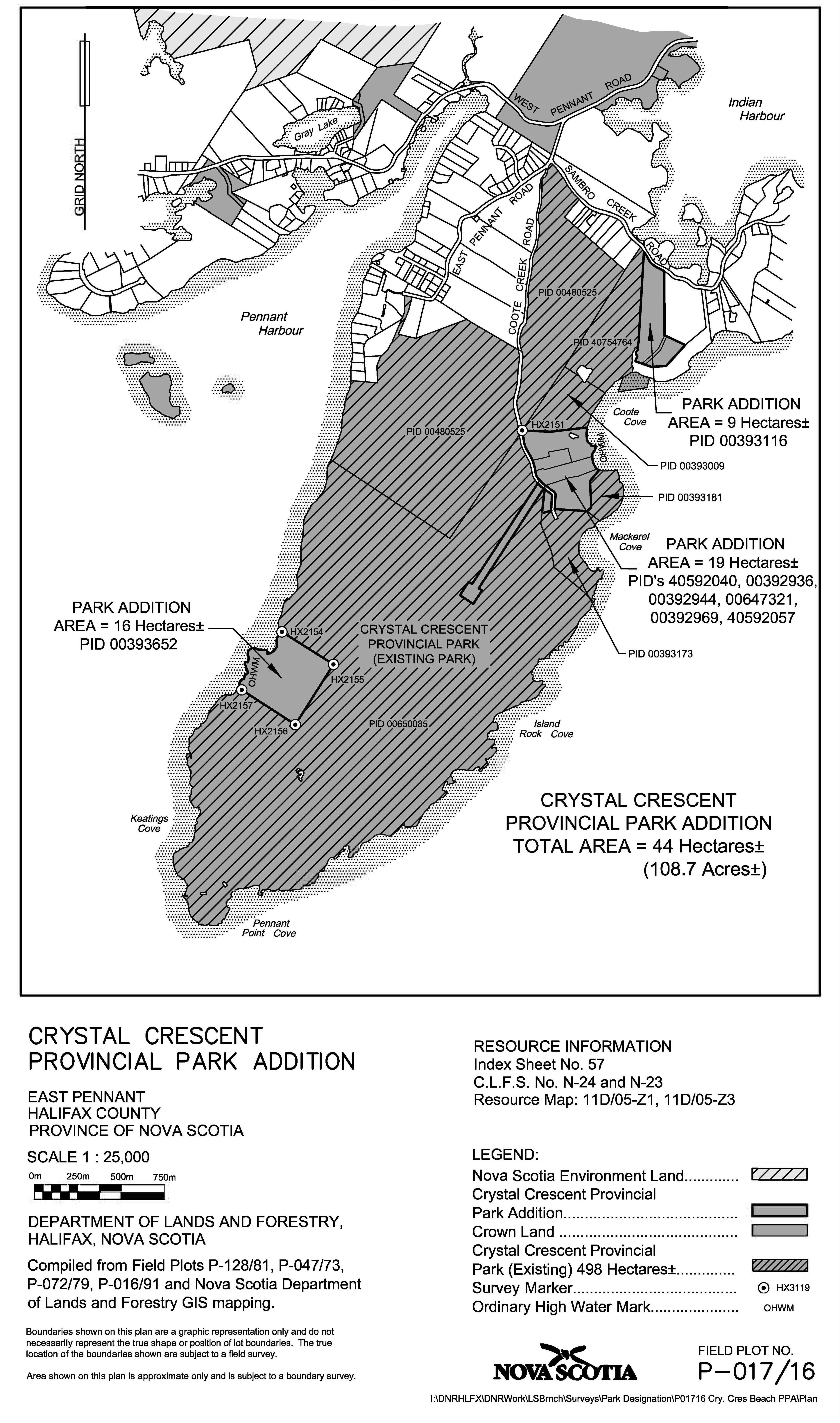
(a) designate Crown lands for addition to Crystal Crescent Provincial Park, originally designated by the Governor in Council by Order in Council 81-1336 dated November 3, 1981, [N.S. Reg. 150/1981,] as shown outlined in bold and shaded dark grey on the plan marked Schedule “A” attached to and forming part of the report and recommendation, which will increase the size of the park by approximately 44.0 hectares (109.7 acres); and
(b) authorize the Minister of Lands and Forestry to execute such documents as may be necessary to achieve the purposes of this Order.
Legislative History
Reference Tables
Crystal Crescent Provincial Park Designation |
N.S. Reg. 150/1981 |
Provincial Parks Act |
|
Note: The information in these tables does not form part of the regulations and is compiled by the Office of the Registrar of Regulations for reference only. |
|
Source Law
The current consolidation of the Crystal Crescent Provincial Park Designation made under the Provincial Parks Act includes all of the following regulations:
N.S. |
In force |
How in force |
Royal Gazette |
150/1981
|
Nov 3, 1981 |
date made |
Dec 3, 1981 |
144/2019 |
Sep 30, 2019 |
date specified |
Oct 11, 2019 |
|
|
|
|
|
|
|
|
|
|
|
|
The following regulations are not yet in force and are not included in the current consolidation:
N.S. |
In force |
How in force |
Royal Gazette |
|
|
|
|
|
|
|
|
|
|
|
|
*See subsection 3(6) of the Regulations Act for
rules about in force dates of regulations.
ad. = added |
fc. = fee change |
rep. = repealed |
|
Provision affected
|
How affected
|
||
.......................................................... |
|
||
|
|
||
|
|
||
|
|
||
|
|
||
Note that changes to headings are not included in the above table.
Editorial Notes and Corrections
|
Note |
Effective |
|
|
|
|
|
|
|
|
|
Repealed and Superseded
N.S. |
Title |
In force |
Repealed |
|
|
|
|
Note: Only regulations that are specifically repealed and replaced appear in this table. It may not reflect the entire history of regulations on this subject matter.