
Geological Data for the Cobequid Highlands
DP ME 148, Version 2, 2006. Digital Geological Data Generated as Part of the Cobequid Highlands Project 1983-1999, Colchester, Cumberland, and Pictou Counties, Nova Scotia, Parts of NTS 11E/05, 11E/06, 11E/11, 11E/12, 21H/07, 21H/08 and 21H/09, by G. Pe-Piper and D. J. W. Piper
Abstract
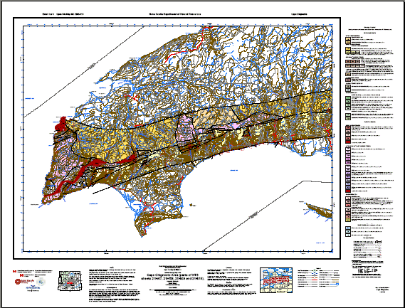
This digital product is a compilation of digital geological data generated as part of the Cobequid Highlands Project 1983-1999, parts of NTS 1:50 000 mapsheets: 11E/05, 11E/06, 11E/11, 11E/12, 21H/07, 21H/08 and 21H/09. Currently available is PDF digital copies of OFM ME 2005-114, OFM ME 2005-115, OFM ME 2005-116, and OFM ME 2005-117, by G. Pe-Piper and D. J. W. Piper.
Funding for this mapping project was provided by the Natural Sciences and Engineering Research Council (NSERC), the Geological Survey of Canada (through Canada - Nova Scotia Mineral Development Agreements, A-base and Natmap funding), and Saint Mary's University.
Disclaimer
The DATA is provided to the USER on an "as is" basis, without warranties of any kind, express or implied. The entire risk as to the quality and accuracy of the DATA is with the USER and the USER shall use his/her own judgment in making use of the DATA or drawing conclusions based upon it. NR&R shall not be liable to the USER, his/her clients, servants, agents, contractors, assigns, or to any other person for any loss or damage of any kind including personal injury or death arising from the use of the DATA or accompanying written materials, or from errors, deficiencies or faults therein, whether such damage is caused by negligence or otherwise. If errors or omissions are found in the DATA, the USER will notify NR&R. The terms and conditions of the license accompany the downloaded digital product.
Format
Portable Document Format (PDF), ArcInfo Interchange Format (E00), DXF/DBF, ArcView 3.2a shape files (SHP) and TXT files compressed in self-extracting EXE/ZIP files (more information on data formats)
Size
PDF - 2.5 MB to 3.5 MB (compressed and uncompressed)
E00 - 2.2 MB (compressed), 30.4 MB (uncompressed)
DXF/DBF - 2.9 MB (compressed), 54.4 MB (uncompressed)
SHP - 3.1 MB (compressed), 46.9 MB (uncompressed)
Projection
The data is in six-degree Universal Transverse Mercator (UTM) projection, Zone 20, Central Meridian 63° 00' West using the North American Datum of 1983 (NAD83).
Downloading Instructions
The data files have been compressed using PKZIP into a single, self-extracting EXE file.
- Read the Licence before accepting the data.
- Download the self-extracting EXE file to the desired location on your hard drive.
- Double click or "RUN" the EXE file and the data files will be unzipped automatically.
The EXE file can also be opened in WinZip to view and extract the compressed files in the data set.
On UNIX platforms, the unzip command will extract the compressed files in the EXE.
All data sets are in six-degree Universal Transverse Mercator (UTM) Zone 20 projection using the NAD83 datum. A readme file and a copy of the licence agreement are also included with each data set.