| This consolidation is unofficial and is for reference only. For the official version of the regulations, consult the original documents on file with the Registry of Regulations, or refer to the Royal Gazette Part II. |
| Regulations are amended frequently. Please check the list of Regulations by Act to see if there are any recent amendments to these regulations filed with the Registry that are not yet included in this consolidation. |
| Although every effort has been made to ensure the accuracy of this electronic version, the Registry of Regulations assumes no responsibility for any discrepancies that may have resulted from reformatting. |
| This electronic version is copyright © 2011, Province of Nova Scotia, all rights reserved. It is for your personal use and may not be copied for the purposes of resale in this or any other form. |
Bennery Lake Watershed Protected Water Area Designation
made under Section 106 of the
Environment Act
S.N.S. 1994-95, c. 1
N.S. Reg. 210/2003 (December 4, 2003)
as amended by N.S. Reg. 25/2013 (January 24, 2013)
Canada
Province of Nova Scotia
In the Matter of: the Environment Act, S.N.S. 1994-95, c.1, s.106
In the Matter of: the designation of an area surrounding Bennery Lake, Halifax Regional Municipality, as a Protected Water Area, to be known as the “Bennery Lake Watershed Protected Water Area”
Designation of the Bennery Lake Watershed Protected Water Area and
the Making of Regulations with Respect Thereto
Whereas Section 106 of Chapter 1 of the Acts of 1994-95, the Environment Act, provides for the designation by the Minister of Environment of a protected water area and the making of regulations under subsection (6) to prohibit, regulate or require the doing of any act or acts in a protected water area that may impair or prevent the impairment, as the case may be, of the quality of the water in the Protected Water Area;
Whereas the operator of the Bennery Lake Water Treatment Plant, the Halifax Regional Municipality, has requested that the Minister of Environment designate a portion of the Bennery Lake Watershed as a Protected Water Area in order to protect the quality of the surface water and groundwater resource as a water supply;
And whereas Halifax Regional Municipality has provided opportunities for public consultation, including public meetings and the establishment of the Bennery Lake Watershed Management Committee, an advisory committee comprising representatives of the Province of Nova Scotia, the Halifax Regional Municipality, the Halifax Watershed Advisory Board, members of the general public and landowners;
Therefore pursuant to Section 106 of Chapter 1 of the Acts of 1994-95, the Environment Act, the undersigned, Kerry Morash, Minister of Environment hereby
(a) designates an area surrounding Bennery Lake more fully described in Schedule “A” as a protected water area, to be known as the “Bennery Lake Watershed Protected Water Area”; and
(b) makes regulations respecting activity in the Bennery Lake Watershed Protected Water Area, in the form set forth in Schedule “B”.
Sgd: K. Morash
Honourable Kerry Morash
Minister of Environment
Halifax, Nova Scotia
December 4, 2003
Schedule “A”
Bennery Lake Watershed Protected Water Area
Boundary Description
All that certain parcel of land situated at Grand Lake, Halifax County, Nova Scotia and being Parcel BL shown on a plan titled “Compiled Plan of BENNERY LAKE WATERSHED” prepared by Robert Wentzell, N.S.L.S., dated January 26, 1999 and being on file at the office of the Director of Public Works and Transportation, Design Services, Halifax Regional Municipality as plan File No. 98031601 and being more particularly described as follows:
Commencing at Nova Scotia Co-ordinate Monument No.11751;
thence N 08° 18' 13” E, 767.038 metres to a point on the northwest boundary of Old Guysborough Road being the point of beginning;
thence N 37° 49' 10” W, 1455.218 metres to a point;
thence N 00° 00' 00” W, 2172.155 metres to a point;
thence N 52° 15' 00” W, 200.000 metres to a point;
thence S 74° 02' 10” W, 677.310 metres to a point;
thence S 49° 30' 10” W, 1235.887 metres to a point;
thence S 23° 22' 31” W, 1535.406 metres to a point;
thence S 60° 05' 26” E , 950.148 metres to a point;
thence S 29° 37' 41” W, 118.457 metres to a point;
thence S 77° 09' 02” E , 1149.643 metres to a point;
thence S 21° 41' 45” E , 831.015 metres to a point;
thence S 37° 51' 58” E , 463.052 metres to a point;
thence N 41°18' 25” E along the northwest boundary of the Old Guysborough Road, 990.579 metres to a deflection therein:
thence N 33° 32' 30” E along the northwest boundary of the Old Guysborough Road, 216.116 metres to the point of beginning.
Parcel BL contains 659.8 hectares.
ALL bearings are based on Zone 5, Central Merdian [Meridian] 64°30' West, of the Nova Scotia 3° Modified Transverse Mercator Projection of ATS77 Geodetic Datum.
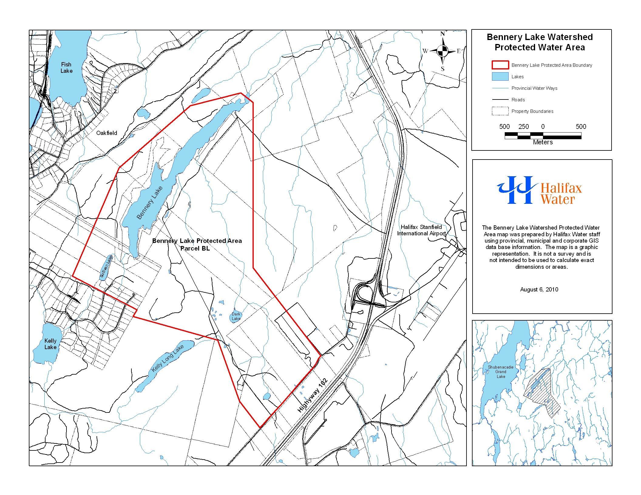
Map Showing Approximate Boundaries of Bennery Lake Watershed Protected Water Area
map added: N.S. Reg. 25/2013.