| This consolidation is unofficial and is for reference only. For the official version of the regulations, consult the original documents on file with the Office of the Registrar of Regulations, or refer to the Royal Gazette Part II. |
| Regulations are amended frequently. Please check the list of Regulations by Act to see if there are any recent amendments to these regulations filed with our office that are not yet included in this consolidation. |
| Although every effort has been made to ensure the accuracy of this electronic version, the Office of the Registrar of Regulations assumes no responsibility for any discrepancies that may have resulted from reformatting. |
| This electronic version is copyright © , Province of Nova Scotia, all rights reserved. It is for your personal use and may not be copied for the purposes of resale in this or any other form. |
Halifax Regional Municipality Interim Planning Area Order
made under subsection 229A(2) of the
Halifax Regional Municipality Charter
N.S. Reg. 195/2025 (effective October 3, 2025)
Table of Contents
Please note: this table of contents is provided for convenience of reference and does not form part of the regulations.
Click here to go to the text of the regulations.
Schedule A: Interim Suburban Area Policies
3. Suburban Planning Vision and Core Concepts
3.3 Transit-oriented Suburban Area Opportunity Sites
3.4 Suburban Growth Area Opportunity Sites
Appendix A: Suburban Growth Area Opportunity Sites
Schedule B: Regional Centre and Suburban Plan Areas
Whereas subsection 4A(3) of the Minimum Planning Requirements Regulations, N.S. Reg. 138/2019, required the Halifax Regional Municipality to implement the minimum planning requirements outlined in subsection 4A(2) of the regulations no later than December 31, 2024;
And whereas the Minister of Growth and Development extended that deadline, at the Municipality’s request, and requested under subsection 229A(1) of the Halifax Regional Municipality Charter that the Municipality adopt a new municipal planning strategy or amend the existing municipal planning strategy to fulfill the minimum planning requirements outlined in subsection 4A(2) of the regulations no later than June 30, 2025;
And whereas the Council did not comply with that request;
Now, therefore, I order the following:
1. The Halifax Regional Municipality is designated as an interim planning area.
2. This interim planning area may be referred to as the “Halifax Regional Municipality Interim Planning Area.”
3. Development within the Halifax Regional Municipality Interim Planning Area is hereby regulated to give effect to clauses 4A(2)(c), (e), (f), (g), (h), (i), (j), (k) and (l) of the Minimum Planning Requirements Regulations.
4. In particular, within the Halifax Regional Municipality Interim Planning Area all of the following apply:
(a) The Regional Municipal Planning Strategy is amended by adding the Interim Suburban Area Policies attached as Schedule A immediately after Section 6.3.2A.
(b) The Interim Suburban Area Policies contained in Schedule A apply to the Suburban Area indicated on the map attached as Schedule B.
(c) For the lands zoned as General Business (C-3) Zone in the Land Use By-law for Dartmouth, residential uses must be permitted, subject to the provisions of the R-1 Single Family Residential Zone (Part 2) of the Land Use By-law for Dartmouth.
(d) The Municipal Planning Strategy for Dartmouth is amended by removing the text “and consistent” in Policy IP-1(c)(2), as shown in strikethrough below:
(2) that the proposal is compatible and consistent with adjacent uses and the existing development form in the area in terms of the use, bulk, and scale of the proposal
(e) The Municipal Planning Strategy for Dartmouth is further amended by adding the reference to the C-3 Zone in Policy IP-5, as underlined below:
It shall be the intention of City Council to consider (RC-May 23/24; E-Jun 13/24) Development Agreements for apartment building development in R-3, R-4, C-2, C-3, MF-1 and GC Zones or shared housing uses at a larger scale than permitted in the underlying zone in R-3, R-4, C-2, MF-1 and GC Zones (RC-Aug 9/22; E-Sep 15/22). Council shall require a site plan, building elevations and perspective drawings for the apartment development indicating such things as the size of the building(s), access & egress to the site, landscaping, amenity space, parking and location of site features such as refuse containers and fuel storage tanks for the building.
(f) For the lands zoned as Highway Oriented Commercial (CHWY) Zone (Part 15) and Cushing Hill Commercial (CHC) Zone (Part 15A) in the Land Use By-law for Bedford, residential uses must be permitted, subject to the provisions of the Residential Two Unit Dwelling (RTU) Zone (Part 7) of the Land Use By-law for Bedford.
(g) For the lands zoned as Downsview Complex-1 (DC-1) Zone (Part 9) and as Downsview Complex-2 (DC-2) Zone (Part 10), residential use must be permitted, subject to the provisions of the Downsview Complex-3 (DC-3) Zone (Part 11) of the Land Use By-law for Sackville Drive.
(h) For developments enabled under the Municipality’s Conservation Design Development policies in the Regional Municipal Planning Strategy that begin construction before April 1, 2028, maximum density of a development must be based on a lot’s gross area.
(i) To support the development of increased housing supply, the Municipality must consider flexibility for modular housing, factory-built housing, mass-timber-constructed housing and other forms of sustainable and affordable construction, through built-form requirements and design guidelines that impact height and density.
(j) When considering an application for a project built with any of the construction methods listed in clause (i), increases in maximum height requirements may be considered to ensure that equivalent building heights in storeys can be built as would be by traditional construction methods.
(k) No requirement related to unit mix may apply to any residential building development that begins construction before April 1, 2028.
(l) No requirement related to the minimum or maximum number of on-site parking spaces may apply to residential uses within the urban service area of the Halifax Regional Municipality Interim Planning Area.
(m) Requirements related to ground floor commercial for residential building development that begin construction before April 1, 2028, must not exceed more than 20%.
(n) Temporary housing in non-permanent structures, such as a work camps, construction camps or mobile homes must be permitted in all zones where it can be safely established to allow employees to live on or near their worksite during a work assignment for a period of time that can be reasonably tied to the duration of the project and that is explicitly set out in the development permit.
(o) Manufactured housing, including modified shipping containers converted into housing, must be permitted in all zones that permit residential uses.
This Order is effective on and after the date it is filed with the Registrar of Regulations.
Dated and made October 2, 2025, at Halifax, Halifax Regional Municipality, Province of Nova Scotia.
sgd. John Lohr
Honourable John Lohr
Minister of Municipal Affairs
Schedule A: Interim Suburban Area Policies
The Suburban Area encompasses lands outside of the Regional Centre, where municipal water and wastewater services and conventional transit are available or planned to be considered, and generally aligned with the Urban Settlement Designation. Land use and development in the Suburban Area is governed by several community plans and land use by-laws which have not been comprehensively updated. The Suburban Planning process will create policies and regulations to achieve the desired form and scale of development at the property level and help identify key investments needed to support both existing and new communities.
a) Adopt a Suburban Secondary Municipal Planning Strategy and a land use by-law which achieves the Vision and Core Concepts set out in these Interim Suburban Area Policies.
b) Foster communities that are attractive, healthy places to live for people of all ages, incomes, backgrounds and abilities and where residents can access goods, services and facilities they need.
c) Enable the design of compact, walkable, transit-supportive communities that are safe and welcoming to residents.
d) Increase housing supply and the mix of housing types available for people of all ages, abilities and income levels and have access to transit, services and amenities.
e) Develop clear and easy to understand planning documents that can adapt to changing community needs and conditions, and simplify rules for residential development.
3. Suburban Planning Vision and Core Concepts
A vision for the Suburban Area was informed by previous community visioning in several suburban communities. This vision is expected to be further refined as part of the Suburban Planning process.
Urban communities are centred around a network of parks and trails, beautiful, walkable, and vibrant centres, main streets, and neighbourhoods. Residents enjoy an easy access to frequent and reliable transit, a wide range of housing options, food, recreation, services, and employment opportunities.
In addition to objectives of this Plan for community planning, the Suburban Planning process will be guided by the following six Core Concepts, which can also be further refined through the planning process:
Complete Communities
Complete communities support people of all ages, backgrounds, abilities, and incomes to sustainably live, work, shop, learn, and play near one another. Historically, suburban communities have developed in a manner that has kept residential areas separate from commercial areas. This means that residents are generally dependent on vehicles to access the services and amenities they require on a daily basis. This Plan supports the creation of more complete and accessible communities by:
• Supporting people of all ages, abilities, and backgrounds to live, work, shop, learn, and play within a short journey;
• Promoting mixed use neighbourhoods with safe and convenient access to goods and services needed in daily life to create positive health outcomes; and
• Using an equity lens when developing land use policies to address housing shortages, and permitting a range of housing options and related land uses.
Safe, Diverse, Sustainable and Affordable Housing
Housing is a key determinant of health because a safe home provides individuals and families the comfort and security they need to work, study, create community connections, and thrive. Housing availability and affordability are currently some of the most urgent priorities facing the municipality. This Plan supports increasing the supply of housing for all household sizes, income levels, and life stages by:
• identifying and removing barriers to increasing housing supply for all residents in safe locations in the suburban area such as reducing minimum required lot frontage, lot size, adaptive reuse, and eliminating parking requirements;
• supporting increased housing density and options in areas with access to transit, infrastructure and services;
• supporting opportunities for diverse forms of housing, including shared housing, co-housing, cluster housing, tiny homes, culturally inclusive housing, and community land trusts;
• expanding opportunities and incentives to support developing and retaining affordable housing;
• increase the diversity of housing types available in all communities so that all residents can choose housing that meets their needs;
• enabling and providing flexibility for innovative housing forms such as net-zero, modular housing, factory-built housing and mass timber constructed housing; and
• collaborating with government, non-profit and private sector partners to end homelessness and housing poverty in the municipality through complementing programs, policies, or regulations.
Open Space and Culture
Suburban communities feature a wide variety of natural and cultural assets that contribute to the character of each neighbourhood. They also play an important role in supporting the health of residents and the environment. This Plan encourages the protection and enhancement of natural and cultural assets by:
• Applying information about important natural features that contribute to sustainability and sense of place in future growth;
• Supporting the integration of natural processes and energy conservation in site design, including preserving, rehabilitating, and restoring natural system functions; and
• Supporting access to active and passive parks and open spaces.
Human-Scale Design
Human-scale design is focused on building and streetscape design that makes people feel more at ease and allows them to relate to their surroundings. It refers to a relationship between the size, shape, and design of components in the urban environment that matches the pace of pedestrians. Buildings and streets, as well as elements like trees and street furniture, all contribute to providing a scale that is comfortable for people. Human-scale design makes urban environments more interesting, encourages exploration, and draws more people to local shops and services. This Plan provides direction for the built environment that respects the human scale by:
• Supporting options for missing middle housing, which is housing such as small multi-unit dwellings and mid-rise multi-unit dwellings; and
• Supporting human-scale experience for taller buildings through design that provides stepbacks for the upper storeys, low streetwalls with architectural detailing, weather protection, and frequent entrances; and
• Supporting connectivity and a mix of uses in the urban environment.
Inclusive and Accessible Design
This Plan supports design that prioritizes the comfort, equity and accessibility for people of all ages and abilities in the built environment, transportation networks, and in public and recreational spaces. When walking, rolling, and other forms of sustainable transportation are safe and more convenient, they become a viable transportation choice. This leads to community benefits, such as emission reductions, improved accessibility, affordability and improved public health. To increase residents’ comfort and convenience when walking or rolling, development in suburban communities will need to be carefully designed. This Plan supports inclusive and accessible design by:
• Supporting accessibility in the built environment, recreation and transportation;
• Prioritizing the needs and comfort of people in all seasons to make walking, rolling and other modes of sustainable transportation more convenient and viable;
• Encouraging land use, transportation and design policies that prioritize walking/rolling, cycling and transit to reduce car dependency; and
• Fostering high-quality architecture and urban design that is interesting and comfortable for people at street level.
Transit Supportive Growth
Dependence on personal vehicles to access employment, education, shopping, and other services and amenities has resulted in significant traffic congestion in suburban communities. This Plan supports easier access to transit by:
• Directing growth to transit corridors, nodes, and under-utilized commercial areas to support inclusive and connected communities; and
• Locating the highest density and mix of uses within a short walk or roll of frequent transit services, and mid-rise and missing middle housing within a short walk or roll of transit facilities or corridors; and
• Supporting connectivity for walking and rolling to facilitate access to transit.
3.3 Transit-oriented Suburban Area Opportunity Sites
The Suburban Community Planning program will involve a comprehensive planning process to develop a vision and future land use structure for the Suburban Area. Given the present housing shortage the urgent priority is to increase the supply of safe, sustainable and affordable housing, it is reasonable to provide additional opportunity to allow those residential or mixed-use development to proceed where they are aligned with the Suburban Community Planning Vision and Core Concepts as outlined in Section 3.2 and are ready to develop. Proposed developments may be considered by development agreement, where certain criteria and requirements can be met including accelerated project start and completion timelines.
Suburban Area Policy 1
Notwithstanding Policy G-7 of the Regional Plan, but subject to Suburban Area Policy 2 and Suburban Area Policy 3 of this Plan, and G-15 of the Regional Plan, prior to the adoption of the Suburban Area Plan, development proposals that align with Section 3.2 of this Plan, for residential or mixed-use buildings that provide primarily residential uses within the Suburban Area and in the Urban Service Boundary, may be considered by development agreement, or an amendment to an existing development agreement, provided they meet the following criteria:
a) the proposed development site is located within the Urban Settlement Designation but outside the Regional Centre Secondary Municipal Plan Area and the Suburban Housing Accelerator Secondary Municipal Plan Area;
b) the proposed development site is located within an 800-metre walkshed of:
i. a planned Bus Rapid Transit (BRT) route or the Mill Cove Ferry Terminal as identified in the Rapid Transit Strategy, as approved by Regional Council on May 26, 2020; or
ii. the Downsview, Cobequid or Sackville Transit Terminals;
c) the proposed development site is no more than 2 hectares in total area;
d) the proposed development must not result in the demolition of an existing building containing three dwelling units or more; and
e) a complete application for a development agreement must be on file with HRM on or before the first notice of the intention of Council to adopt the Suburban Plan.
Suburban Area Policy 2
In considering an application for a development agreement or an amendment to a development agreement under Suburban Area Policy 1, HRM shall consider:
a) that the development’s permitted density and built form on the site considers walking distance to transit, local context and transitions in height and massing to low-rise residential neighbourhoods;
b) the development’s site design supports necessary infrastructure upgrades;
c) whether to vary the built form and land use requirements in the Housing Accelerator Zone and applicable section of the Suburban Housing Accelerator Land Use By-Law;
d) on-site and off-site improvements necessary to integrate the development in the surrounding area, including street and active transportation that support Bus Rapid Transit Corridors;
e) whether ground floor commercial or institutional space is included to support local services and employment uses;
f) whether the proposal considers including a mix of uses, ground-oriented units, landscaping and pedestrian connectivity;
g) provisions for incentive or bonus zoning consistent with requirements set out in policies in Section 9.7A of the Regional Plan and applicable land use by-laws;
h) the project commencement date shall not exceed 18 months with one opportunity for a one-time extension not exceeding 6 months; and
i) the project completion date shall not exceed three years from the date of commencement.
Suburban Area Policy 3
A Development Agreement, or an amendment to development agreement, under Suburban Area Policy 1 and Suburban Area Policy 2 shall:
a) for a development that is located:
i. in a low-density residential area that is not near bus rapid transit routes, the Mill Cove Ferry Terminal, or the Downsview, Cobequid or Sackville Terminals, not exceed the built form for a low-rise building as set out in the Suburban Housing Accelerator Land Use By-Law;
ii. near bus rapid transit routes, the Mill Cove Ferry Terminal, or the Downsview, Cobequid or Sackville Terminals and abuts a low-density residential area, not exceed the mid-rise built form as set out in the Suburban Housing Accelerator Land Use By-Law; and
iii. near bus rapid transit routes, the Mill Cove Ferry Terminal or the Downsview, Cobequid or Sackville Terminals, and not abutting low-density residential areas, not exceed the tall mid-rise built form as set out in the Suburban Housing Accelerator Land Use By-Law;
b) unless otherwise varied by the development agreement, require the applicable provisions of the Suburban Housing Accelerator Land Use By-Law to apply;
Suburban Area Policy 4
Notwithstanding Suburban Area Policy 3 (a)(i) to (iii) inclusive, greater building heights may be considered where:
a) studies show regional and local water, wastewater and transportation infrastructure, emergency services, parks and community facilities can support additional density; and
b) the design of the site and building complements the neighborhood context in terms of transition in height.
New Suburban Growth Area Development Policy:
3.4 Suburban Growth Area Opportunity Sites
Suburban communities will play a critical role in the region’s ability to be responsive to a quickly growing population. Key opportunities for significant mixed-use development will be on underutilized sites which are located close to existing or planned transit terminals, frequent transit routes and proposed rapid transit stations. These centres or hubs can be further supported by mixed use development along other transit corridors, and infill in existing multi-unit neighborhoods. Community services and post-secondary areas can also provide opportunities for additional housing, including student housing.
The Suburban Planning process will direct population and employment density to encourage transit-supportive growth in complete communities, using a built form-based approach to land use planning which prioritizes high quality urban design. Areas of small-scale infill within established residential areas are also envisioned to contribute to the development of complete communities that are compatible with the surrounding context.
Transit-oriented development in complete communities in the Suburban Area will guide strategic investments in services and infrastructure and help to support a viable rapid transit service. The detailed boundaries of growth areas and the land use policies guiding development in the Suburban Area will be determined through the Suburban Planning process. Several Suburban Growth Area Opportunity sites, as identified in Table 3-3A and Appendix A to this Plan, have been identified as existing underutilized sites in key locations that could be redeveloped. These sites present an opportunity for new housing development that is needed to support the significant demand for housing of all types across the Municipality. Comprehensive planning in these areas will determine future land uses and densities, the needed local and regional infrastructure to support building complete communities, and the appropriate planning tools. Developments may be phased provided that overall site design and infrastructure are considered.
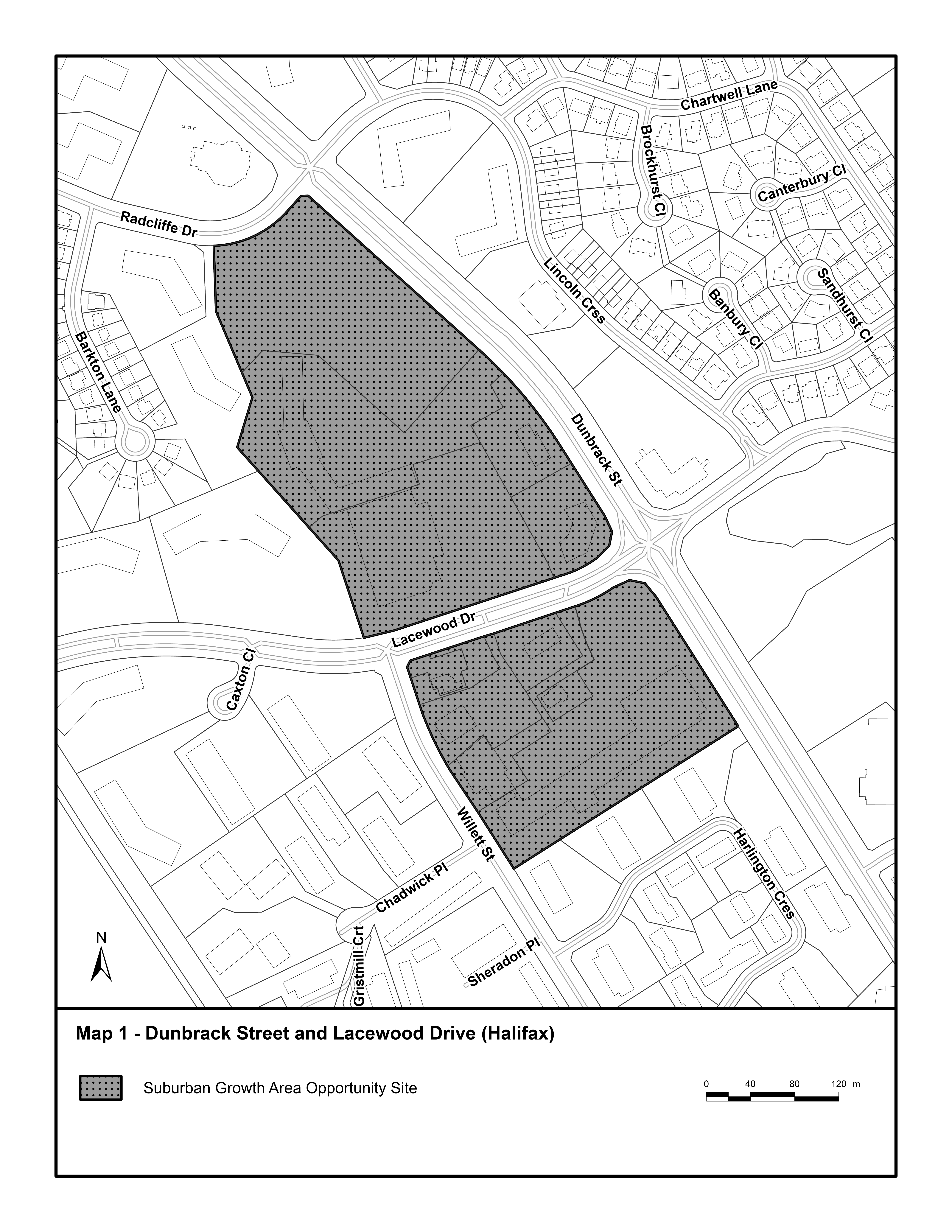
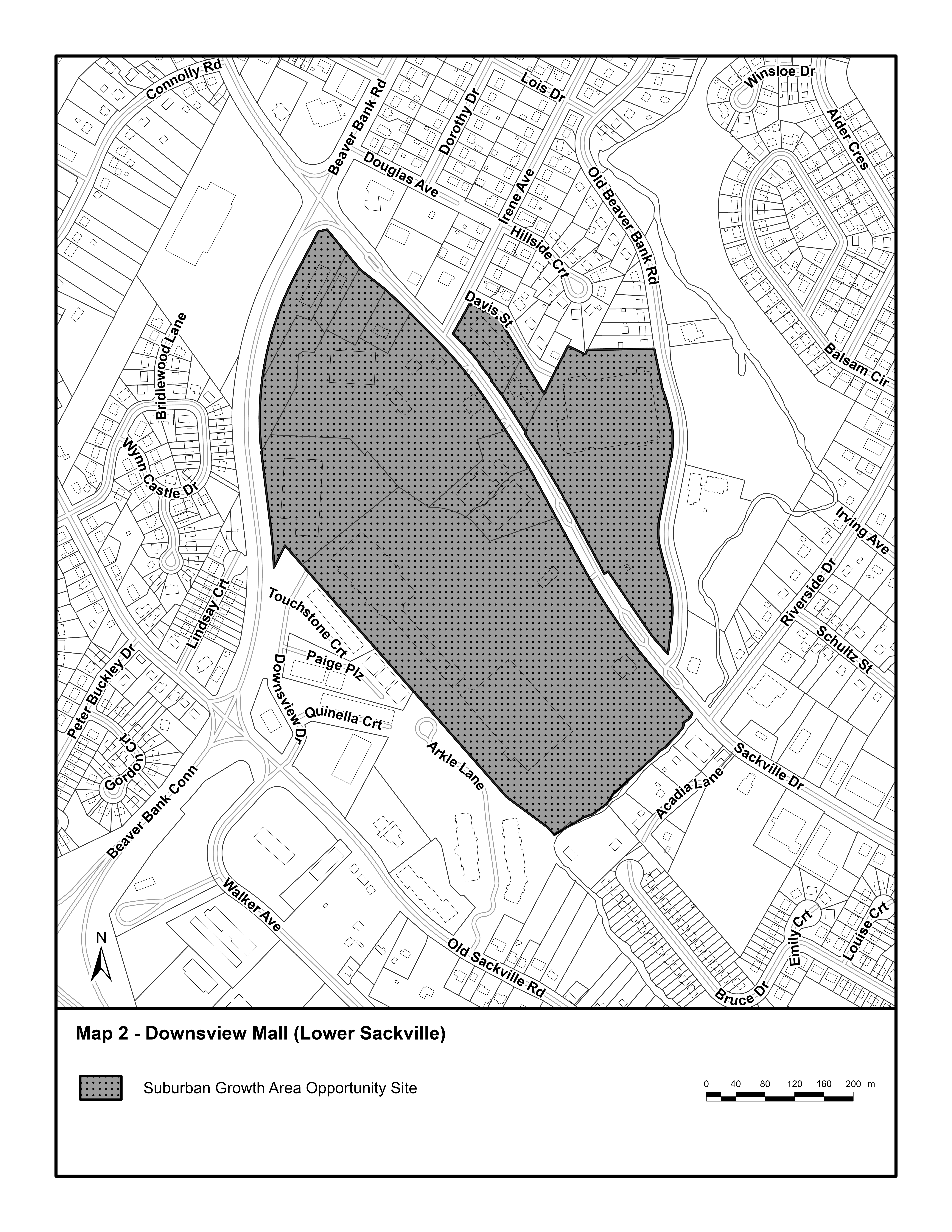
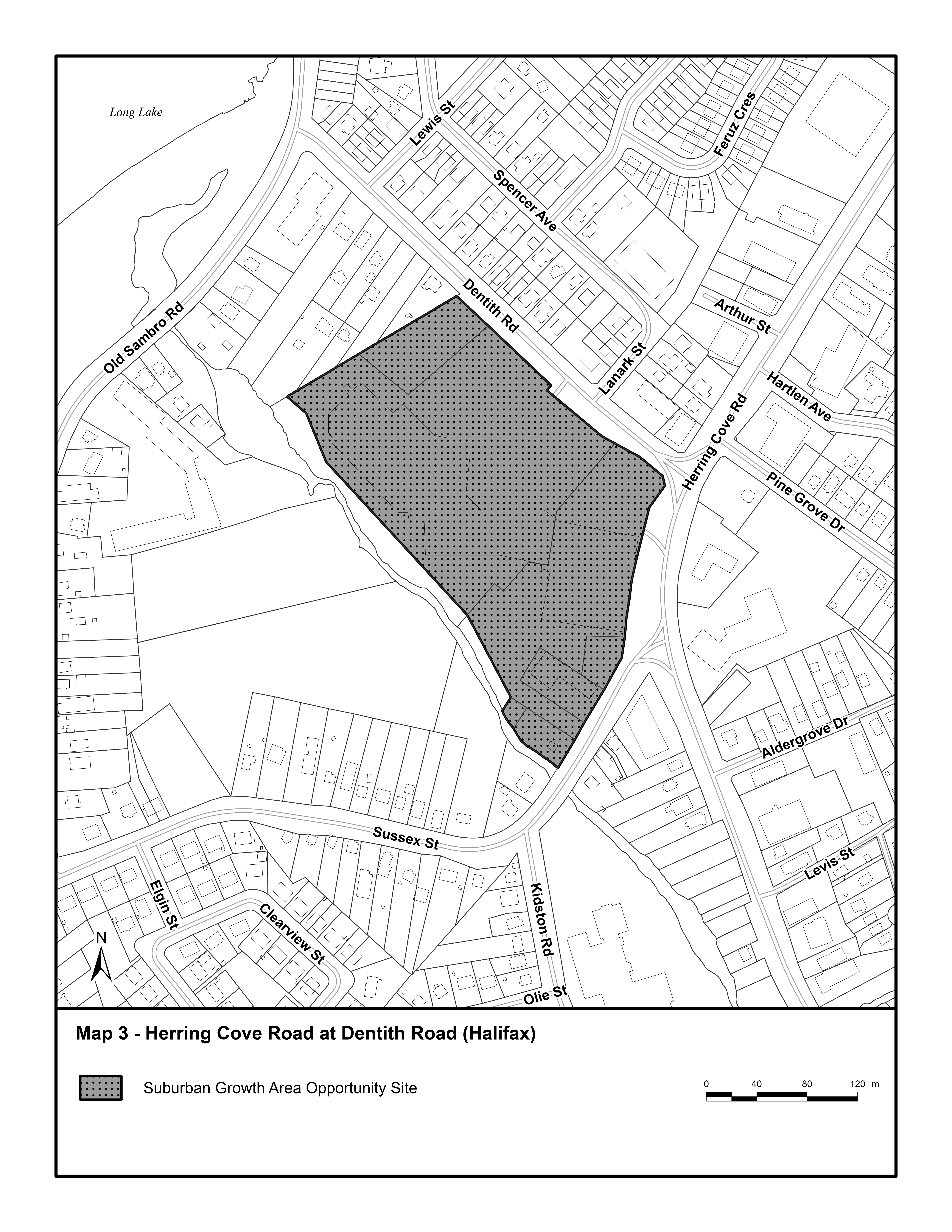
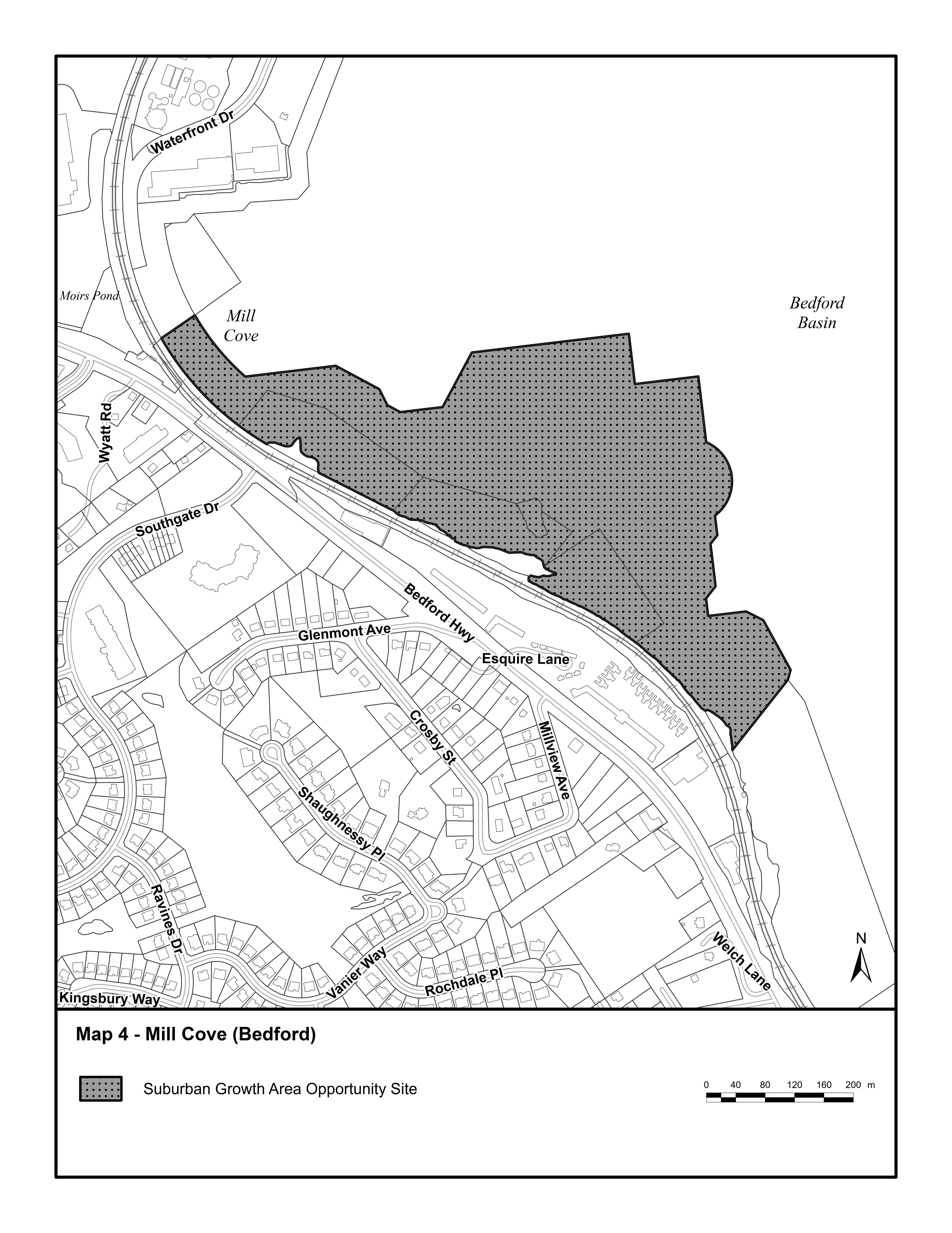
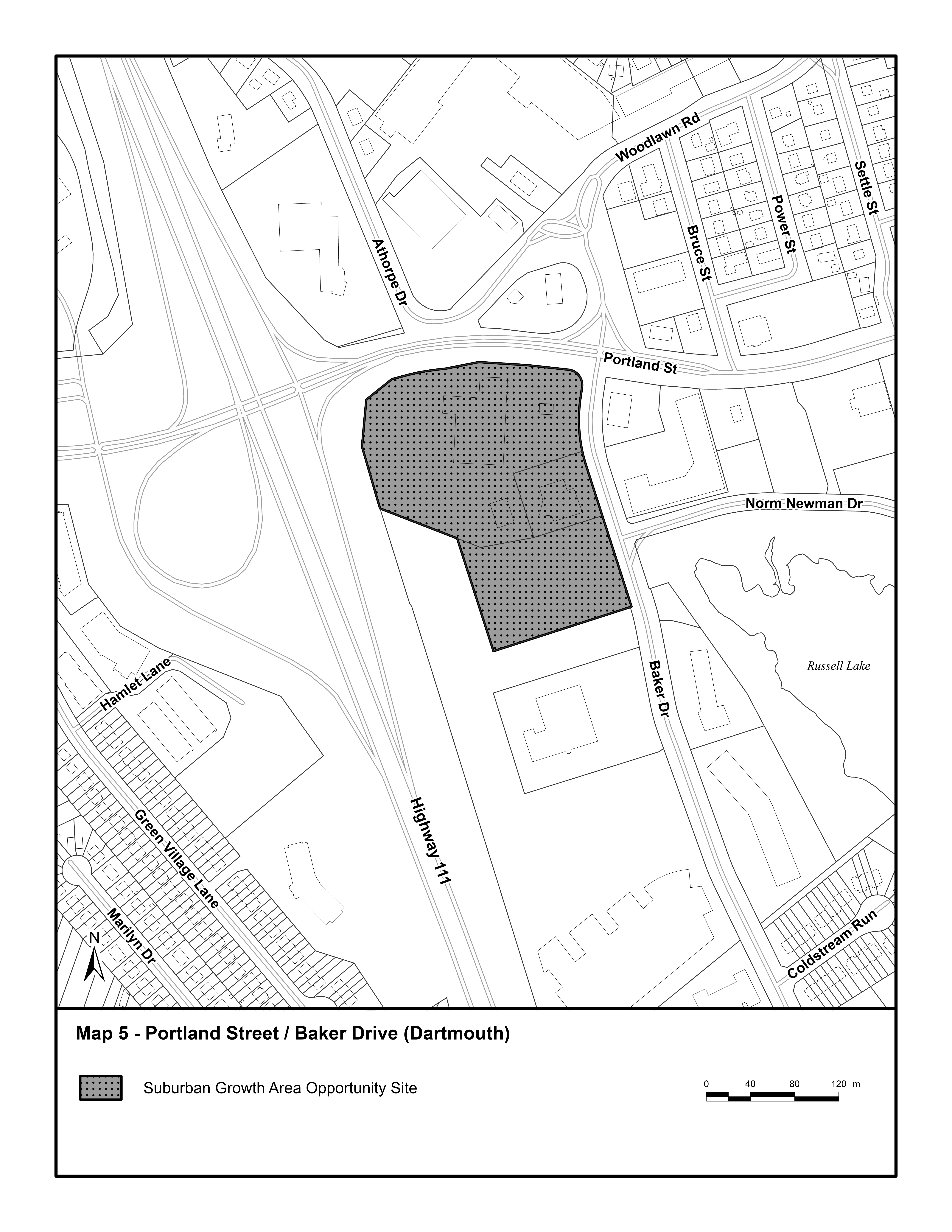
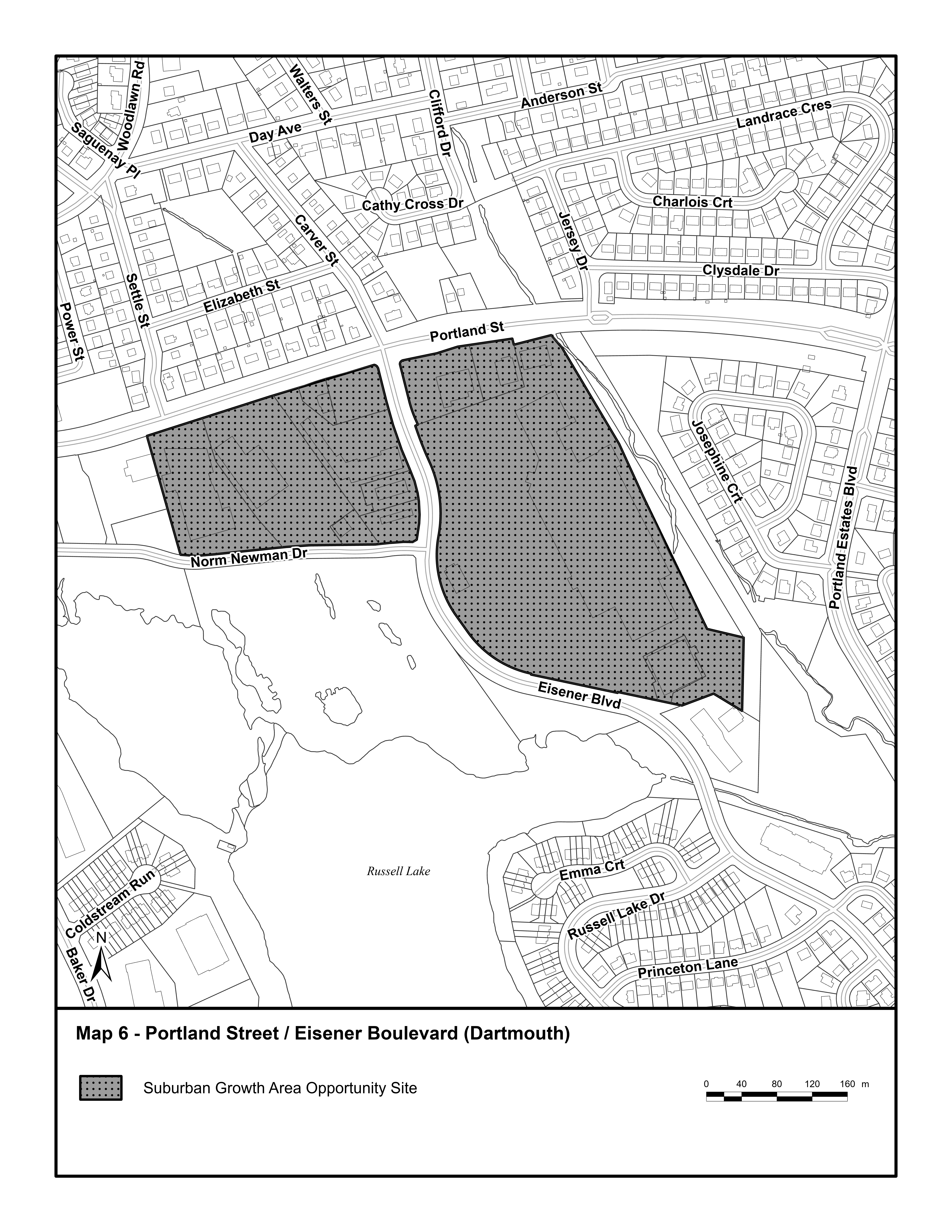
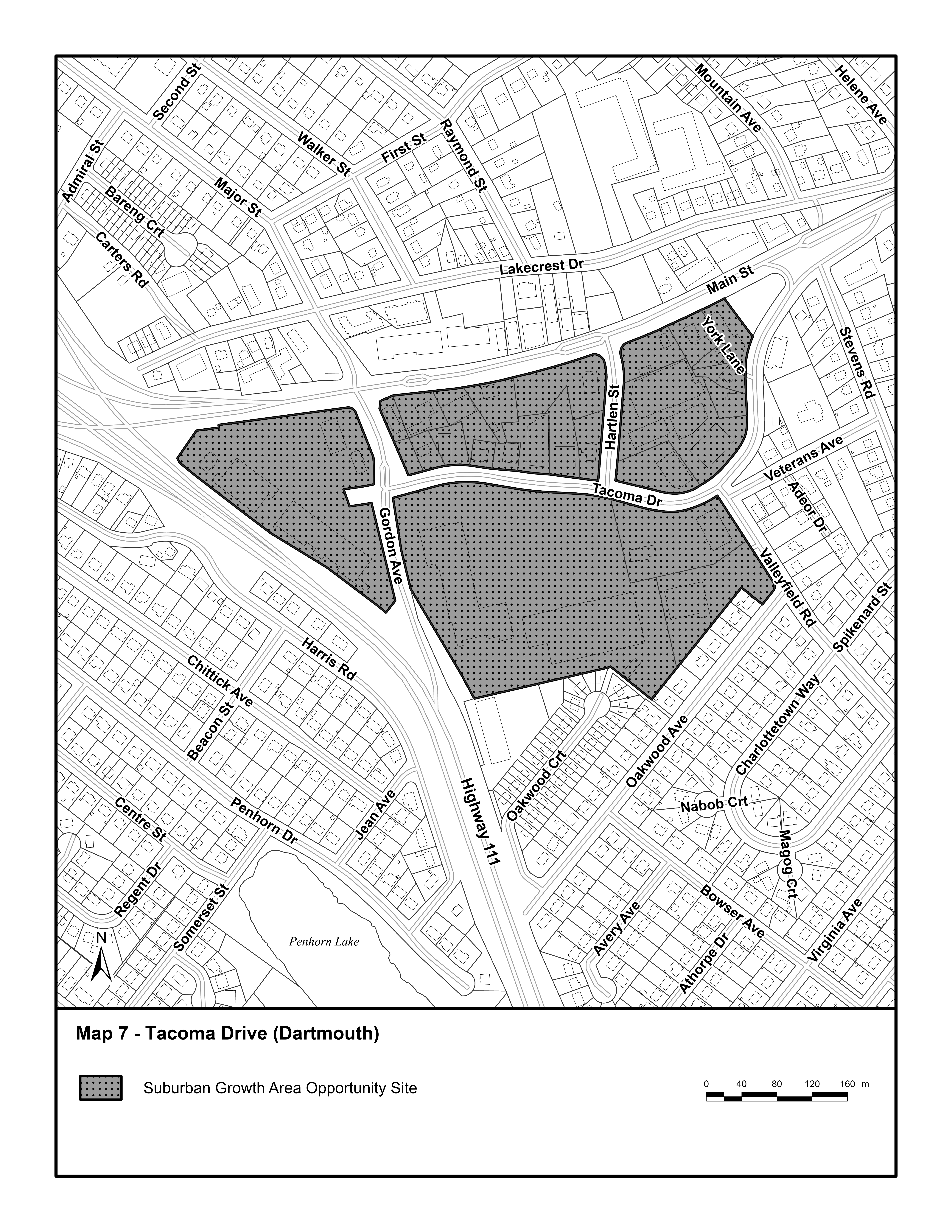
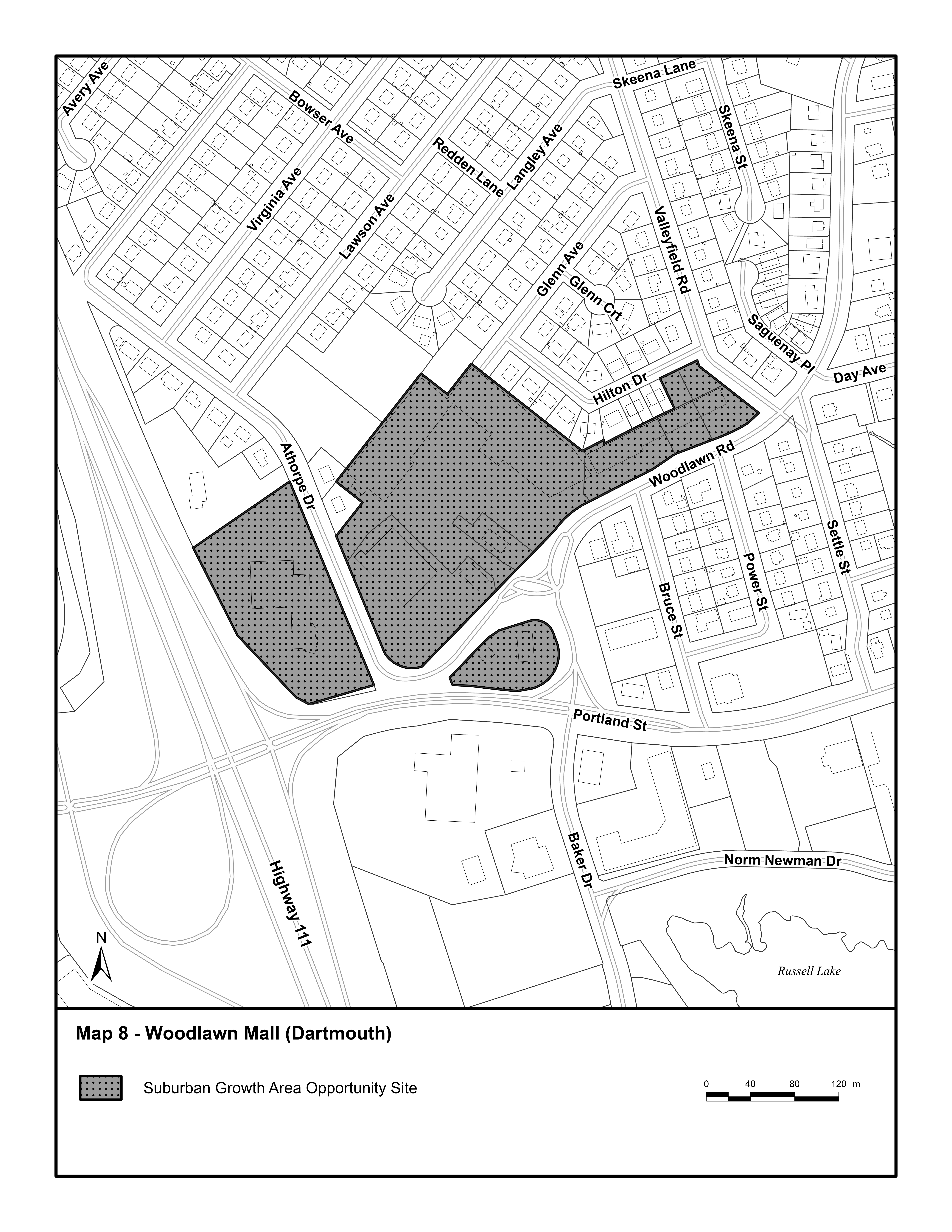
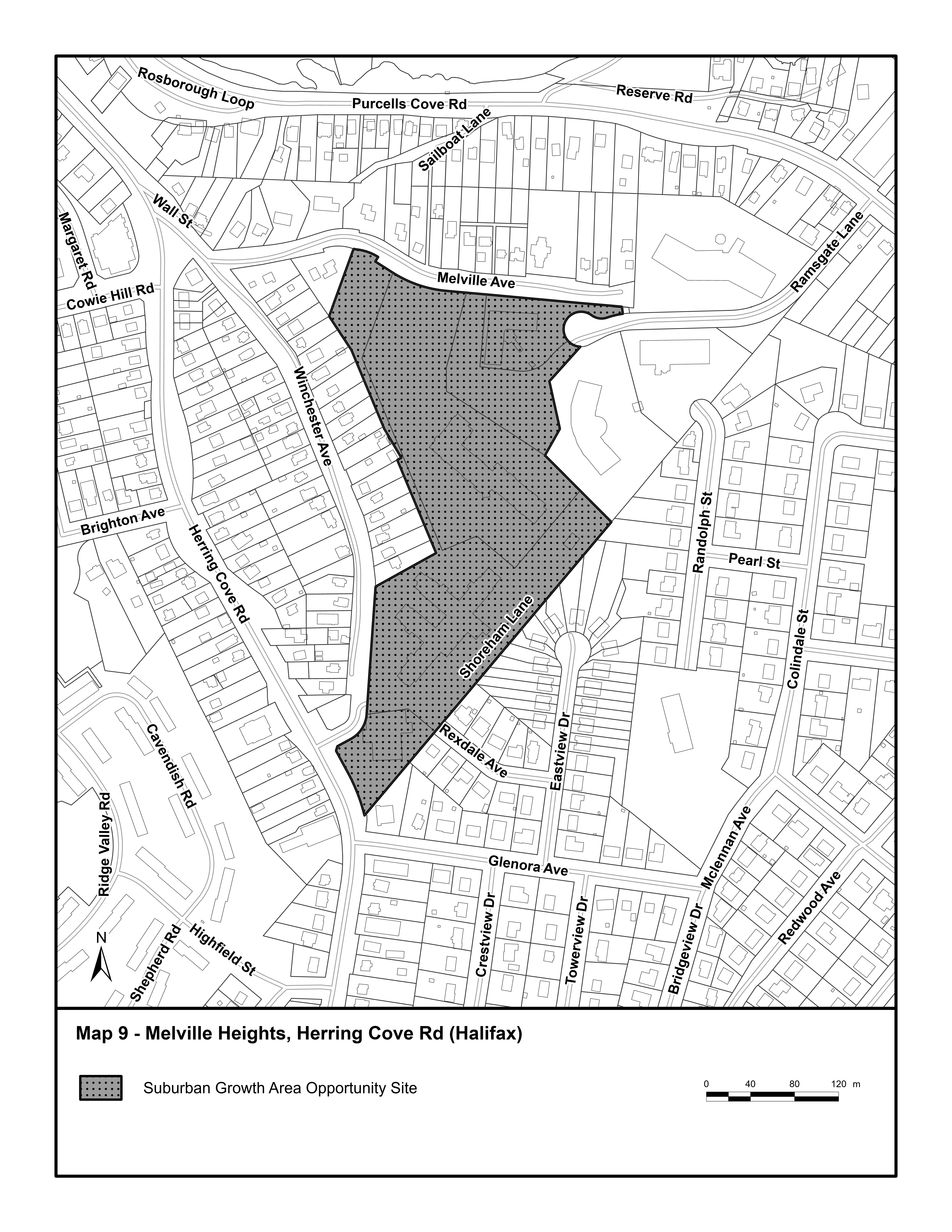
Table 3-3A: Suburban Growth Area Opportunity Sites |
Dunbrack Street and Lacewood Drive |
Downsview Mall |
Herring Cove Road at Dentith Road |
Mill Cove |
Portland Street/Baker Drive |
Portland Street/Eisener Boulevard |
Tacoma Drive |
Woodlawn Mall |
Melville Heights, Herring Cove Road |
Suburban Area Policy 5
It shall be the intent of this Plan to support the strategic and efficient delivery of services and infrastructure and promote complete communities in the Suburban Area that are pedestrian- and transit-supportive and provide safe and convenient access to jobs, goods and services. Notwithstanding the provisions of the applicable secondary municipal planning strategy and Suburban Area Policy 1, a neighbourhood planning process may be undertaken for any of the Suburban Growth Area Opportunity Sites identified in Table 3.3A and shown on Appendix A. A neighbourhood planning process includes project initiation, engagement, necessary studies, development of a concept plan, development of a land use framework (land use policies and by-laws), and approval by Council.
When considering initiating a planning process to develop detailed policies and land use regulations for potential opportunity sites, the Municipality shall consider:
a) efficient use of planning tools to support timely development, including allowing for phased development;
b) the applicable policies of this Plan, including the Suburban Planning Vision and Core Concepts as outlined in Section 3.2, and suburban design guidelines;
c) the level of existing services and infrastructure supporting existing neighbourhoods;
d) regional and local water, wastewater and transportation infrastructure, emergency services, parks, community facilities and other services;
e) opportunities for planned infrastructure investments and efficient service delivery;
f) whether the mobility network, including the location of existing or proposed transit services, streets and active transportation facilities prioritize pedestrians, cyclists and transit and are connected;
g) land uses and site design support a mixed-use neighbourhood with a range of housing opportunities, built forms, places of employment, and services where daily needs of residents can be met;
h) the adequacy of public parks, open spaces, and community facilities to meet the recreational needs of residents;
i) measures to support new developments to be integrated with surrounding uses and neighbourhoods;
j) whether site design mitigates impacts to and integrates significant environmental and cultural features;
k) climate risks and opportunities to mitigate any potential impacts, such as overland flooding or stormwater management;
l) risks, impacts and opportunities associated with nearby railways and highways; and
m) impacts to municipal infrastructure and the need, if any, to concurrently approve by-laws to pay for growth related municipal infrastructure.
Suburban Area Policy 6
For developments considered under Suburban Area Policy 5, initial phases may proceed through a development agreement or rezoning prior to the completion of the neighbourhood planning process, subject to the following:
a) the completion of a concept plan accepted by the Regional Council that includes at a minimum:
i. the overall proposed development densities;
ii. the classes and locations of the land uses proposed;
iii. proposed phasing of development;
iv. the proposed transportation network, including connections to abutting public streets or highways, the anticipated major pedestrian traffic patterns, and the need for any on-site transit facilities or off-site network improvements;
v. the location of any significant natural or cultural features, including watercourses, flood risk areas, or wetlands within and adjacent to the area of land;
vi. the proposed location of any public parks, open spaces and community recreation facilities; and
vii. the proposed location of any school, emergency facility or community facility sites;
b) consideration of the applicable policies in Suburban Area Policy 5, and applicable direction contained in the Regional Plan;
c) studies showing regional and local water, wastewater and transportation infrastructure, emergency services, parks and community facilities can support the initial phase of the development; and establishing provisions for incentive or bonus zoning and infrastructure cost contributions.
Appendix A: Suburban Growth Area Opportunity Sites
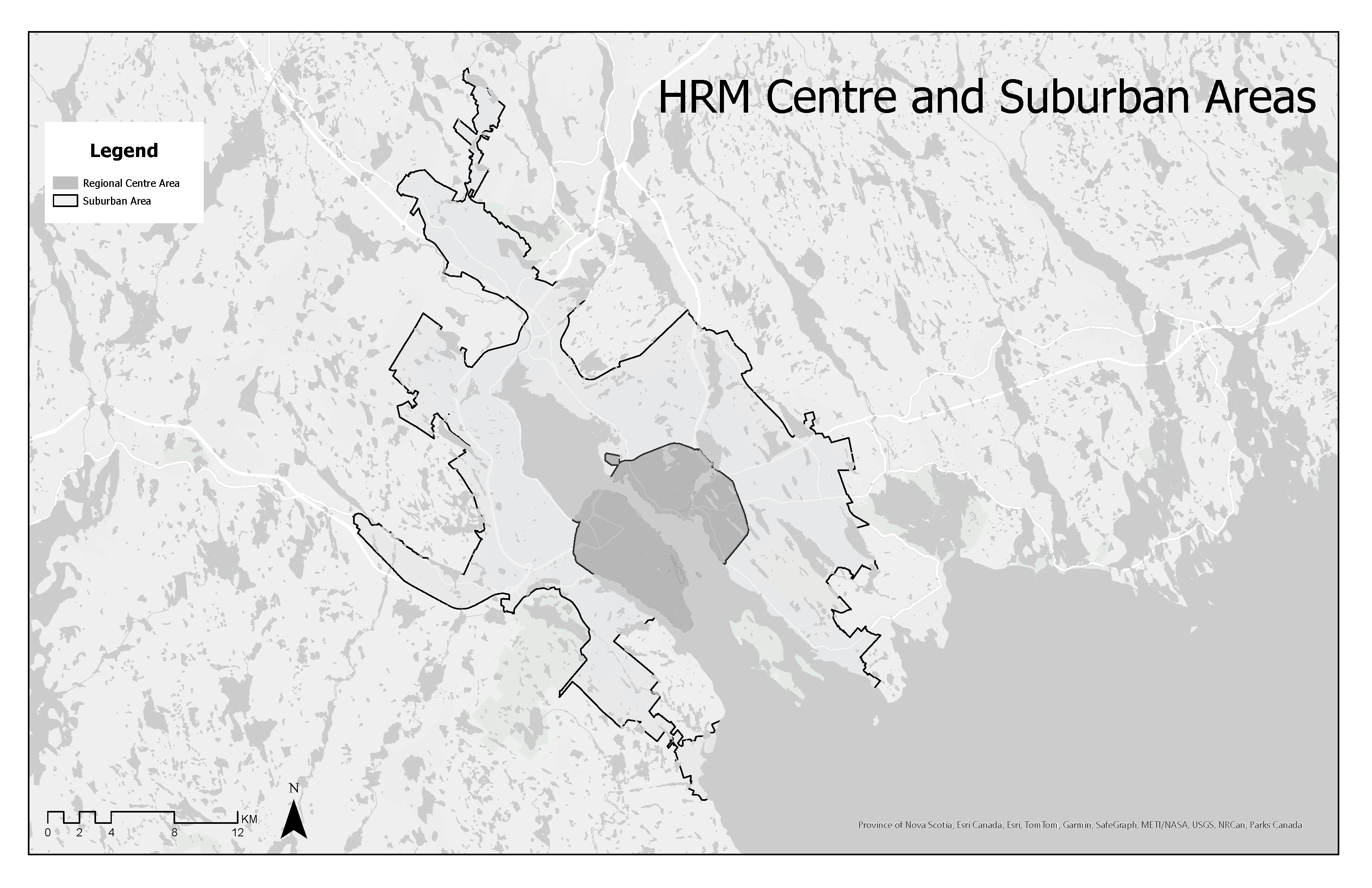
Schedule B: Regional Centre and Suburban Plan Areas