| This consolidation is unofficial and is for reference only. For the official version of the regulations, consult the original documents on file with the Registry of Regulations, or refer to the Royal Gazette Part II. |
| Regulations are amended frequently. Please check the list of Regulations by Act to see if there are any recent amendments to these regulations filed with the Registry that are not yet included in this consolidation. |
| Although every effort has been made to ensure the accuracy of this electronic version, the Registry of Regulations assumes no responsibility for any discrepancies that may have resulted from reformatting. |
| This electronic version is copyright © 2009, Province of Nova Scotia, all rights reserved. It is for your personal use and may not be copied for the purposes of resale in this or any other form. |
Grassy Island Wildlife Management Area Designation
made under Section 15 and subsection 113(1) of the
Wildlife Act
R.S.N.S. 1989, c. 504
O.I.C. 2007-190 (March 30, 2007), N.S. Reg. 202/2007
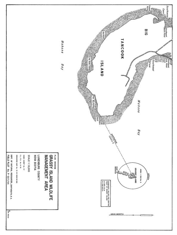
The following area, the approximate boundaries of which are shown on the map attached as Appendix A to this designation, is designated as a wildlife management area to be known as Grassy Island Wildlife Management Area:
All that certain area of land including land covered by water, known as Grassy Island, situate, lying and being seaward from the extreme easterly shoreline of Big Tancook Island, known as Southern Head, County of Lunenburg, Province of Nova Scotia, said area is shown on the attached plan having field plot number P-017/94 and is more particularly described as follows:
Commencing at a point, said point being the approximate geographic centre of Grassy Island, said point being N 65° 00' 00" E a distance of 1250 m more or less from the most easterly shoreline of Big Tancook Island known as Southern Head; said point also having grid coordinates of North 4922712 m, East 5528502 m referenced to the 3° Modified Transverse Mercator Projection, Zone 5, Central Meridian 64° 30' West longitude;
From thence S 20° 00' 00" W following a radial line of a circle 250 m to the point of beginning;
Thence in a clockwise direction following the circumference of a circle having a constant radius of 250 m, an arc distance of 1570.8 m to the point of beginning containing an area of 19.6 ha more or less.
Appendix “A”
Map of Grassy Island Wildlife Management Area
