| This consolidation is unofficial and is for reference only. For the official version of the regulations, consult the original documents on file with the Registry of Regulations, or refer to the Royal Gazette Part II. |
| Regulations are amended frequently. Please check the list of Regulations by Act to see if there are any recent amendments to these regulations filed with the Registry that are not yet included in this consolidation. |
| Although every effort has been made to ensure the accuracy of this electronic version, the Registry of Regulations assumes no responsibility for any discrepancies that may have resulted from reformatting. |
| This electronic version is copyright © 2009, Province of Nova Scotia, all rights reserved. It is for your personal use and may not be copied for the purposes of resale in this or any other form. |
| Land Surveyors Regulations |
|---|
Land Surveyors Act
R.S.N.S. 1989, c. 249
O.I.C. 88-908 (Sept. 13, 1988), N.S. Reg. 188/88
as amended up to & including O.I.C. 1999-569 (Nov 25, 1999), N.S. Reg. 127/99
Definitions
1 In these regulations
(a) "Act" means the Nova Scotia Land Surveyors Act;
(b) "Association" means the Association of Nova Scotia Land Surveyors constituted by the Act;
(c) "Board" means the Board of Examiners of the Association;
(d) "by-law" means a by-law of the Association;
(e) "Complaints Committee" means a committee of the Association appointed pursuant to Section 24 of the Act;
(f) "corporation" means a body corporate;
(g) "Council" means the Council of the Association as defined in Section 4 of the Act;
(h) "Discipline Committee" means a committee of the Association appointed pursuant to Section 25 of the Act;
(i) "member" means a person as defined in the Act.
2 For the purpose of the Act and the[se] regulations, "professional misconduct" means infamous, disgraceful or improper conduct on the part of a member, student member or holder of a certificate of authorization and, without restricting the generality of the foregoing, includes
(a) gross negligence in the discharge of duties;
(b) technical incompetence in the practice of professional land surveying;
(c) a breach of the Code of Ethics (Part III of the[se] regulations), the Act, the[se] regulations or the by-laws;
(d) a conviction for an indictable offence under the Criminal Code of Canada or under any other statute of the Parliament of Canada;
(e) wilful and malicious conduct which causes the Association to be brought into disrepute; or
(f) failure to respond within a reasonable period of time to official correspondence from the Association.
3 The hearing of a complaint under oath filed with the Secretary in accordance with Section 24 of the Act shall be convened by the Discipline Committee no later than six months from the date the complaint was filed.
4 Where an order issued pursuant to Section 26 of the Act suspends a member, student member or holder of a certificate of authorization, directs the cancellation of membership of a member or student member, or directs the cancellation of the certificate of a holder of a certificate of authorization and the suspension or cancellation has become effective in accordance with the Act, the Discipline Committee shall direct the Secretary and the Secretary shall
(a) advise and forward a copy of the order in summary form certified by the Secretary to each federal, provincial or municipal department or office that may use or approve the use of plans or documents prepared by the member, student member or holder of a certificate of authorization who has been suspended or whose membership has been cancelled;
(b) cause a notice of the suspension or cancellation to be published in at least two newspapers having general circulation in the area in which the member, student member or holder of a certificate of authorization so disciplined carried on practice; and
(c) publish in the Association's publication such order in summary form certified by the Secretary.
5 Where an order issued pursuant to Section 26 of the Act reprimands a member, student member or holder of a certificate of authorization and the reprimand has become effective in accordance with the Act, the Discipline Committee shall direct the Secretary and the Secretary shall advise the members of the Association of such reprimand and the circumstances meriting its imposition by placing a notice in the Association's publication.
6 The forms set out in the Schedule "A" to these regulations, or those forms varied to suit the case or forms to like effect, shall be deemed to be good, valid and sufficient in the circumstances for which, respectively, they are provided.
7 (1) Part II of the[se] regulations shall apply to a member, student member and holder of a certificate of authorization.
(2) The following definitions apply in Part II:
(a) "check-measured" means that the value of a quantity has been determined by at least two independent observations using different methods so that the possibility of significant error in the accepted value is eliminated;
(b) "closed traverse" means a traverse which begins and ends at the same point or points whose relative positions have been determined independently;
(c) "co-ordinate monument" means a monument for which co-ordinates in the Nova Scotia Co-ordinate Survey System have been adopted by the body having jurisdiction over the said System;
(d) "description" means a written definition of the boundaries of real property;
(e) GPS means Global Positioning System, a satellite-based system used for navigation, positioning and survey measurements;
Clause 7(2)(e) added: O.I.C. 1999-569, N.S. Reg. 127/99.
(f) "monument" means a marker placed by or under the supervision of a member to define a point on the boundary of lands under survey;
Clause 7(2)(e) relettered (f): O.I.C. 1999-569, N.S. Reg. 127/99.
(g) "offset" means the measurement of the direction and length of a single straight line from a point fixed by survey to another nearby point which it is required to fix;
Clause 7(2)(f) relettered (g): O.I.C. 1999-569, N.S. Reg. 127/99.
(h) "ordinary high water mark" means the limit or edge of a body of water where the land has been covered by water so long as to wrest it from vegetation or as to mark a distinct character upon the vegetation where it extends into the water or upon the soil itself;
Clause 7(2)(g) relettered (h): O.I.C. 1999-569, N.S. Reg. 127/99.
(i) radial observation means a unique determination of the position of one survey station or monument relative to another;
Clause 7(2)(i) added: O.I.C. 1999-569, N.S. Reg. 127/99.
(j) "survey" means professional land surveying as defined in the Act;
Clause 7(2)(h) relettered (j): O.I.C. 1999-569, N.S. Reg. 127/99.
(k) "surveyor" means a member, student member, or holder of a certificate of authorization;
Clause 7(2)(i) relettered (k): O.I.C. 1999-569, N.S. Reg. 127/99.
(l) "survey firm" means a holder of a certificate of authorization or a member carrying on a sole proprietorship in the practice of professional land surveying;
Clause 7(2)(j) relettered (l): O.I.C. 1999-569, N.S. Reg. 127/99.
(m) "triangulation" means a survey network consisting of triangles in which angles are measured to a high degree of accuracy and selected sides are measured to provide scale;
Clause 7(2)(k) relettered (m): O.I.C. 1999-569, N.S. Reg. 127/99.
(n) "trilateration" means a survey network consisting of triangles in which only the sides of the triangles are measured and which contain sufficient redundancy of lines to permit a determination of the required accuracy and to reveal gross errors.
Clause 7(2)(l) relettered (n): O.I.C. 1999-569, N.S. Reg. 127/99.
8 (1) The provisions of Part II shall govern the standards of surveys made under the Act.
(2) Notwithstanding the provisions of Part II, where an applicable federal, provincial or municipal regulation relating to a survey imposes a higher standard than is imposed by Part II, the higher standard shall be followed.
Survey equipment
9 All instruments and survey equipment shall be kept in good working order and tested frequently to ensure that they operate within design tolerances and meet the accuracy standards specified in Section 17.
Section 9 amended: O.I.C. 1999-569, N.S. Reg. 127/99.
10 The transit or theodolite shall have a horizontal and a vertical reading each with a least count of not more than one minute.
11 All tapes used to measure distances shall be steel tapes graduated in units and decimals of units.
12 All electronic measuring equipment shall be tested on a calibrated base line or network, the length or relative positions of which have been determined by an authority approved by Council, including monuments in the Nova Scotia Co-ordinate Survey System.
Section 12 replaced: O.I.C. 1999-569, N.S. Reg. 127/99.
Respecting the manner of making surveys
13 Before completing a survey, the surveyor shall refer to all available pertinent documentary evidence relating to the land being surveyed and the lands adjoining or any such evidence that may affect the boundaries under survey.
14 Except as provided in Section 15, all boundaries under survey shall be measured directly or shall be determined by closed traverse, triangulation, trilateration, or check measured radial observation.
Section 14 amended: O.I.C. 1999-569, N.S. Reg. 127/99.
15 Where a boundary survey is made of a long, narrow parcel of land, it is not necessary to survey both of the longer boundaries directly but one or both may be established from a check- measured offset line or a closed traverse.
16 Elevations used in the determination of a property boundary shall be based on the Canadian Geodetic Datum.
17 Subject to Section 8, the following accuracies shall be the minimum standard
(a) if the angular closure in any traverse exceeds 30 n seconds (where "n" equals the number of angles measured in the traverse) and if the gross error cannot be detected and corrected by localized remeasurement, all the angles in the traverse shall be remeasured;
(b)two measurements of the length of a line shall agree to within one part in five thousand plus 30 millimetres (1:5000 plus 30 mm);
Clause 17(b) amended: O.I.C. 1999-569, N.S. Reg. 127/99.
(c) the maximum allowable error of closure of a traverse after angular adjustment shall be one part in five thousand plus 30 millimetres (1:5000 plus 30 mm);
Clause 17(c) amended: O.I.C. 1999-569, N.S. Reg. 127/99.
(d) the maximum allowable error or closure in a line of levels shall be 30 k millimetres (where "k" is the number of kilometres in the circuit);
(e) the minimum horizontal accuracy and vertical accuracy of surveys carried out with GPS technology shall be r cm, where r = 2(d+1.5) and d = the distance in kilometres between survey stations or monuments;
Clause 17(e) added: O.I.C. 1999-569, N.S. Reg. 127/99.
(f) notwithstanding the requirements of clauses (a), (b), (c) and (e), surveys to retrace the boundaries of uncultivated lands where no immediate transfer of ownership or development is foreseen other than for forest utilization shall meet a minimum relative accuracy of one part in one thousand (1:1000).
Clause 17(e) relettered (f) and amended: O.I.C. 1999-569, N.S. Reg. 127/99.
18 If the error of closure is to be distributed, the compass rule or a superior adjustment shall be used.
19 (1) Bearings shall be derived from 2 or more suitably spaced monuments of the Nova Scotia Co-ordinate Survey System, by astronomic observation or by differential carrier phase GPS observation.
(2) Where undue hardship and expense that prevent the determination of bearings as specified in subsection (1) can be shown to exist, a surveyor may use a magnetic bearing reference, provided that at least 2 angular ties are made to permanent visible points.
(3) A survey carried out under subsection 17(f) may be based on a magnetic bearing reference or bearings derived from differential code phase GPS observation.
(4) All bearings except those obtained by magnetic compass shall be referenced to the appropriate central meridian of the Nova Scotia Co-ordinate Survey System.
(5) A survey shall be referenced to the Nova Scotia Co-ordinate Survey System with a measured bearing and distance to 1 or more nearby co-ordinate monuments and co-ordinate monuments used for the survey shall be verified as undisturbed by measurement.
(6) A survey may be exempt from the requirements of subsection (5) where undue hardship and expense can be shown to exist.
Section 19 replaced: O.I.C. 1999-569, N.S. Reg. 127/99.
20 Directions of a property boundary in a survey shall be expressed in
(a) full circle bearings which means the bearing of any line is the angle measured clockwise from 0 degrees up to 360 degrees where 0 degrees is the northerly bearing of any line parallel to the reference meridian; or
(b) quadrantal bearings.
21 Linear measurements in a survey shall be expressed in either feet and decimals thereof or in metres and decimals thereof, or both.
22 (1) The position of a natural boundary under survey shall be determined from boundary points selected as frequently as the re-establishment of the irregular boundary requires with no interval between points being greater than 75 metres.
(2) Points referred to in subsection (1) shall be located by traversing with periodic offsets to the boundary, by radial techniques, by controlled photogrammetric methods or by stadia measurements of not more than 150 metres in length from stations on a closed traverse.
23 Except where existing rights are to the contrary, in the case of water boundaries [the] ordinary high water mark shall be used as the feature defining the boundary.
24 (1) (a) Notwithstanding Section 15, all boundary lines through wooded areas shall be well brushed out, unless in the opinion of the surveyor such action would have an adverse effect on the value or esthetics of the property.
(b) All boundary lines not brushed out shall be clearly indicated as such on the plan of survey.
(2) In any instance where the distance between two monuments on a particular line exceeds 100 metres the line shall be blazed as follows:
(i) suitable trees standing within one metre of the line shall be blazed fore and aft and on the side toward the line, or the trees shall be blazed at forty-five degree angles to the line,
(ii) suitable trees standing between one and two metres from the line shall be marked with a single blaze facing the line,
(iii) trees left standing on a boundary line shall be marked with a single blaze fore and aft,
(iv) all blazes shall be made with an axe.
(3) When sufficient evidence exists along a boundary line so as to render its location distinguishable, the boundary line need not be brushed or blazed as the case may be.
(4) Road, street or highway boundaries need not be brushed or blazed as the case may be.
Section 24 replaced: O.I.C. 92-937, N.S. Reg. 205/92.
25 Where a significant discrepancy is found while surveying an old line or a line run by another surveyor, the discrepancy shall be fully described on the plan.
26 When trial lines are run during the course of a survey, no trees shall be blazed or any permanent marks established, but, should a line be run and marked with the intention of establishing a boundary and thereafter found incorrect, all permanent marks and monuments shall be removed therefrom and nothing left that might in the future be mistaken for the true line.
27 (1) When retracing old lines, care shall be exercised not to indiscriminately destroy old evidence.
(2) New blazes shall be made so as not to obscure the age of an old line.
(3) Damaged, deteriorated or disturbed evidence shall be replaced with monuments that meet current regulations, where applicable.
Subsection 27(3) replaced: O.I.C. 92-937, N.S. Reg. 205/92.
Preparation of field notes
28 Field notes are to contain a clear detailed account of everything found, observed and done in the field in the course of a survey, including
(a) a neat detailed sketch with a north arrow to indicate the orientation;
(b) the name of the owner of the property or the client or designation of area being surveyed;
(c) the date of the observations on each page;
(d) the type and identification of all measuring equipment used;
(e) the names of all personnel on the survey and their duties;
(f) the type of weather conditions under which the field work was done;
(g) the entry of all quantitative observations or measurements, including slope, sag, temperature and tape correction, where applicable; and
(h) a complete description of every monument found, placed or restored and of every permanent structure referencing a monument and a note indicating monuments not found.
29 Incorrect entries in field notes shall be stroked out in such a way that they remain legible but are obviously discarded.
30 Field notes are to be recorded at the time of observation and shall be of such quality to facilitate their clear reproduction.
31 All field notes shall be preserved by the member charged with the responsibility of the survey in relation to such notes or filed in accordance with Section 34 or 35.
32 Each survey shall have a supporting file kept by the member or survey firm, containing
(a) a record of all searches made for evidence (physical, documentary or verbal) and the results of such searches;
(b) references to photographic material, old plans, old conveyances and other material used for information;
(c) all pertinent computations;
(d) the survey contract or client's instructions; and
(e) a copy of the description and report resulting from the survey.
33 All original field notes, plans and supporting files shall belong to the member or survey firm whose responsibility it shall be for their safekeeping.
34 When a member or survey firm ceases to do business in the Province, notice shall be filed with the Secretary of the Association advising of the address where the plans and field notes owned by the member or survey firm will be kept.
35 A member or survey firm ceasing the practice of land surveying may request the Association to accept plans and field notes for safekeeping, in which case the Association shall provide storage and reasonable access to the information to all surveyors.
Monumentation of boundaries
36 Placed monuments shall be classified as follows:
(a) (i) "survey marker" means a round iron or round steel post with a minimum diameter of 15 millimetres and a minimum length of 750 millimetres fitted with an aluminium, brass or other approved identification cap on top and placed in the ground so that the identification cap is not more than 100 millimetres above the level of the ground.
(ii) Designation on plan - "![]() "
"
(iii) Official Abbreviation - "SM"
(b) (i) "rock post" means an aluminium, brass or other approved identification cap fitted on a metal shaft at least 10 millimetres in diameter and 50 millimetres long and secured in concrete, bedrock or boulder to the full depth of the shaft. The cap may be omitted where it constitutes a demonstrable hazard.
(ii) Designation on plan - "![]() "
"
(iii) Official Abbreviation - "RP"
(c) (i) "cut cross" means a mark in the form of a cross 80 millimetres in both width and length, cut into bedrock or concrete so that the width and depth of the cut mark is 10 millimetres.
(ii) Designation on plan - "![]() "
"
(iii) Official Abbreviation - "CC"
Section 36 amended: O.I.C. 92-937, N.S. Reg. 205/92.
37 (a) When a survey is made, all angles and points of curvature of the boundary or boundaries under survey, being either retraced or created, shall be defined by one of the monument classifications prescribed in the regulations or by found evidence which, in the opinion of the surveyor, adequately marks the boundary;.
(b) When a survey includes curved boundaries along an existing road, it is sufficient to monument the intersections of the road boundary and the property boundary and to show calculated points of curvature along the road boundary.
(c) Where the boundaries of an air space or of land covered with water are to be defined, their location shall be referenced to at least two related monuments or to the Nova Scotia Co-ordinate Survey System.
Section 37 replaced: O.I.C. 92-937, N.S. Reg. 205/92.
38 Monuments shall be placed on boundaries at suitable locations to a density of at least one per 1 kilometre and, if practical, at least one within sight of each terminal point.
39 Where a boundary evidence no longer exists, all available information concerning its original position shall be considered in the re-establishment thereof.
Section 39 amended: O.I.C. 92-937, N.S. Reg. 205/92.
40 Where in the course of a survey an evidence from a previous survey is located, that evidence shall be completely described and all references to it prefixed by the abbreviation "Fd".
Section 40 amended: O.I.C. 92-937, N.S. Reg. 205/92.
41 (1) The identification cap to be fitted on a survey marker or rock post is to be cast or stamped with the lettering "SURVEY MARKER - PENALTY FOR REMOVAL", or such other lettering as may be approved by Council, together with the member's number, letters or a symbol which will identify the member or survey firm responsible for the placement of the monument.
(2) The use of such letters or a symbol referred to in subsection (1) must be approved by Council.
42 The Secretary of the Association shall maintain a register for the identification of any letters or symbols to be used on survey monuments.
43 Where it is impractical to comply fully with the monumentation regulations because of the nature of the location of a boundary point, a point shall be defined by a monument that would appear to others to have been set by a surveyor or referenced by at least three measured ties from the point to permanent objects, and it shall be shown on the plan with a full description.
44 (1) (a) Where it is impossible or inadvisable to monument a true angle or point of intersection, or where it is determined that the location of a monument will place it in immediate danger of destruction, as in the case of lots fronting on an undeveloped street, one witness monument stamped "WIT" shall be placed at a suitable point as near as practicable to its intended location and on one of the boundaries under survey.
Clause 44(1)(a) replaced: O.I.C. 92-937, N.S. Reg. 205/92.
(b) A record shall be made of the exact bearing and distance from the witness monument to the true corner.
(2) (a) Where a boundary line terminates at a natural boundary, a monument shall be placed on the boundary line far enough from the natural boundary as to be reasonably safe from destruction.
(b) An accurate record shall be made of the distance along the boundary line between the natural boundary and the monument.
45 (1) Where a monument is placed to define a boundary or a corner in a wooded area, a wooden post or other suitable guide post shall be planted beside the monument and a cairn of stones placed around the monument.
(2) Three blazed reference trees or a squared tree close to the monument may be used in lieu of a guide post.
(3) Any wooden posts used under this Section shall be at least 100 millimetres square and 1.5 metres long with a pyramid shaped top.
Preparation of plans
46 (1) When a plan is required, it shall be of the tracing linen or plastic tracing film type and shall be drawn and executed in black drafting ink.
(2) Subsection (1) does not preclude the use of preprinted sheets, add on "tru stick" type certificate forms, or other forms as may be approved by Council from time to time.
47 A plan shall be neat and clear and in fit condition for making legible reproductions.
48 When preparing a plan, the quality of lettering shall be equivalent to the professional appearance and consistency given by mechanical lettering guides.
49 The area, boundary or boundaries directly dealt with by the plan shall be drawn so as to be easily distinguished by its greater weight from all other lines on the plan.
50 A plan or a reproducible copy of a plan shall not be folded.
51 Plans drawn in metric shall be drawn to one of the following natural scales:
| 1:1 000 000
1: 750 000 1: 500 000 1: 250 000 1: 200 000 |
1:100 000
1: 75 000 1: 50 000 1: 25 000 1: 20 000 |
1:10 000
1: 7 500 1: 5 000 1: 2 500 1: 2 000 |
1:1 000
1: 750 1: 500 1: 250 1: 200 |
1:100
1: 75 1: 50 1: 25 1: 20 |
Section 51 amended: O.I.C. 91-596, N.S. Reg. 111/91.
52 To ensure clarity of information, those portions of the plan that contain considerable and congested detail shall be shown in tabular form or as large scale inserts.
53 There shall be a borderline on each plan located at least 10 millimetres from each edge of the sheet and no numbers or letters shall appear outside this borderline.
54 Plan sheet sizes shall conform to the list of dimensions set out in Schedule "B" attached.
55 The diagram on the plan shall be oriented so that north is generally towards the top of the plan.
56 Plans shall be lettered so as to be read from the bottom and right side only.
57 The legend of the plan shall
(a) have a notation of the bearing system used, how it was derived, its reference meridian and its date, if applicable;
(b) have an explanation of the symbols and abbreviations used;
(c) indicate whether distances and bearings shown on the plan are measured or adjusted values and, if they are adjusted values, the legend shall indicate the nature of the adjustment and whether or not a scale factor has been applied to the distances;
(d) show the scale factor used, if applicable; and
(e) show the dates of the field work in the following form: field surveys were carried out during the period (date) to (date), or field surveys were carried out on (date).
58 A simple north symbol, accurately plotted, shall be placed in a conspicuous position on each plan.
59 A location map of an adequate scale shall be drafted on the plan and shall bear the same orientation as the diagram.
60 The diagram on the plan shall show
(a) the accurately plotted boundaries under survey, with the distances and bearings as determined by the survey, and where the boundary under survey follows along a curve, the length along the curve and the radius of the curve shall be shown;
Clause 60(a) replaced: O.I.C. 91-596, N.S. Reg. 111/91.
(b) rights-of-way and easements encountered during the course of the survey;
(c) the perpendicular or radial width of all streets, rights-of-way and easements encountered during the course of the survey;
(d) the graphical location of all buildings lying within 3 metres of either side of any boundary dealt with and such buildings shall be shown by means of perpendicular distances from such boundary;
(e) (i) the accurate location and type of all monuments found or placed;
(ii) survey monuments shall be designated on the plan by symbols and such symbols shall be shown and identified by name in the legend;
(iii) in the case of a witness monument, the symbol of the monument shall be prefixed with the abbreviation "Wit";
(f) the name of the owner(s) of the parcel(s) dealt with by the survey and the name of the owner(s) or the identifier(s) of all adjoining properties;
(g) all natural boundaries which shall be plotted to an accuracy consistent with the field techniques used to define such boundaries;
(h) the location and direction of flow of all watercourses that intersect the boundaries under survey and their names if known;
(i) all fences, walls, blazed lines, monuments, hedges and other evidentiary items which were found and considered as evidence of or related to any boundaries under survey;
(j) the angular relationship(s) and distance(s) if measured from each co-ordinate monument used;
(k) the graphic indication of the co-terminal boundaries of all adjoining properties;
(l) the area of each complete parcel dealt with by the survey to 0.04 percent of the total area or to the nearest 0.1 square metre (square foot), except that in the case of properties with natural boundaries, the area shall not be shown with greater apparent accuracy than can be obtained from the field data;
(m) apparent encroachments; and
(n) references to documentary evidence considered in boundary determination and plan preparation.
61 (1) Sufficient data shall be shown on the plan to permit the calculation of a closure of each parcel surveyed.
(2) In situations where only certain boundaries are surveyed, a note shall be made on the plan indicating how the "open ended" work was checked.
62 A plan shall have a title block located in the lower right hand corner, which shall be comprised of
(a) (i) a descriptive heading in the following form or other like form: "Plan of Survey of ___________________", "Plan of __________________ Subdivision", "Plan of Resurvey of _______________", "Plan of Survey of the northern and western boundaries of ______________________";
(ii) where all boundaries of a parcel of land have not been surveyed, the descriptive heading shall not imply that the plan represents a survey of the complete parcel;
(b) the name(s) of the present or recent owner(s) of the parcel under survey;
(c) the location of the parcel under survey, in terms of street, city, county and province or highway, district, county and province or in similar terms;
(d) (i) the name of the member or survey firm in a discreet lettering size sufficient for information purposes only;
(ii) the name of the member or survey firm shall not be presented on the plan in any manner that could be construed as self-laudatory pursuant to Article VIII of the Code of Ethics;
(e) the date of the plan which shall be the date of the Surveyors Certificate as defined in Section 64 of the regulations; and
(f) the scale.
63 Where plans are prepared in the Metric (SI) System, areas shall be shown on the plan in either square metres or hectares or both if required.
64 (1) A plan shall bear a surveyor's certificate in the following form:
Surveyor's certificate
I, (print name of member), Nova Scotia Land Surveyor, hereby certify that the survey represented by this plan was conducted under my supervision and that the survey and plan were made in accordance with the Nova Scotia Land Surveyors Act and the regulations made thereunder.Dated this _____ day of _______________, 19____
__________________________________, N.S.L.S.
(2) The surveyors certificate shall be accompanied by the member's stamp which shall be obtained from the Association in the form approved by Council.
65 All plans or a reproducible copy of same shall be retained by the member or survey firm or filed in accordance with Sections 34 and 35.
66 Revisions made to a plan shall be identified, dated and initialled by the member, but an unrevised reproducible copy of the original shall be retained by the member or survey firm.
67 Where required, a plan shall be accompanied by a report, signed and dated by the member, setting forth
(a) all pertinent information as to the position of old boundaries; and
(b) the nature and source of the evidence of the position of old boundaries.
Preparation of descriptions
(For descriptions prepared from surveys and plans made under these regulations)
68 A description of a surveyed parcel of land shall be clear, unambiguously worded and shall not contain conditions that may be impossible to fulfil.
69 The preamble of a description shall include
(a) the name of the street, city, town, village, district or municipality, county and province where the parcel is located; and
(b) the parcel identifier, title and date of the plan and the name of the member who signed the plan.
70 The point of beginning shall be carefully chosen so as to be a point capable of being re-established at any time with technical and legal certainty.
71 The bearing and length of each boundary line shall be clearly stated, and
(a) if the bearings refer to an astronomic or grid meridian, the location of such meridian shall be specified; or
(b) if the bearings are referred to a magnetic meridian, the year in which the meridian was established shall be specified.
72 The terminal points of a natural boundary shall be mathematically related so as to enable closure of the parcel under description.
73 (1) Where a description includes a course along a curved boundary, the direction of the curve, the length of the curve, and the radius of the curve shall be given.
(2) Notwithstanding subsection (1), in the case of a previously established boundary of irregular or undetermined curvature, the approximate length of the curved boundary and the mathematical relationship of the terminal points shall be specified in a manner similar to the requirements of Section 72.
74 An area shall be specified for each parcel being described.
75 Sections 71 to 73 do not apply to a description of an existing unsurveyed lot or to unsurveyed portions of a lot for which a full survey has not been performed.
76 Where such information is readily available, the description shall refer to the previous title document.
77 Definitions used in Part I and Part II of the[se] regulations shall apply to Part III.
78 Unless otherwise stated, the following Code of Ethics shall apply to all members, student members and holders of certificates of authorization.
Article I
79 (1) The surveyor shall assist in preventing the unauthorized practice of the profession.
(2) (a) The member shall not sign a certificate, report or plan relating to work not carried out under the member's personal supervision.
(b) The surveyor shall not knowingly and willingly become an accessory to any unauthorized practice by failing to report such practice to Council.
(c) The surveyor shall not establish or maintain branch offices unless these offices are under the direction and management of a member.
Article II
80 (1) The surveyor shall assist in maintaining the integrity and competence of the survey profession.
(2) (a) The member shall assume the professional responsibility for all professional land surveying carried out under the personal supervision of the member.
(b) The member shall not further the application for admission to the profession of another person known by the member to be unqualified by nature of that person's character, education or other attributes.
(c) The surveyor shall continually advance the surveyor's knowledge and skills by participating in activities put on by the Association and shall endeavour to attend relevant continuing education programs.
(d) The surveyor shall at all times serve a client or an employer to the best of the surveyor's knowledge and ability.
Article III
81 (1) The member shall assist a student under the member's direction to achieve an optimum level of contribution to the survey profession.
(2) (a) The member shall instruct such student in the theoretical and practical aspects of land surveying to the best of the member's ability.
(b) The member shall attempt to instill in such student the utmost integrity and a clear understanding of the professional obligation to society.
Article IV
82 (1) The surveyor shall assess and receive fair and just compensation from a client commensurate with the technical complexity, level of responsibility and liability potential of the services performed, except where gratuitous services are warranted.
(2) (a) The surveyor shall not enter into any fee-splitting arrangements with any person other than another surveyor engaged on the same project.
Clauses 82(2)(b) & (c) repealed: O.I.C. 94-679, N.S. Reg. 136/94.
(d) The surveyor shall make available to a client, on request, a copy of details relevant to the assessment for compensation.
(e) The surveyor shall not use the advantages of a salaried position to compete unfairly with other surveyors.
Article V
83 (1) The surveyor shall avoid even the appearance of professional impropriety.
(2) (a) The surveyor shall disclose to a client any conflict of interest, affiliation or prior involvement that could impair the quality of services to the client.
(b) The surveyor shall not permit the surveyor's name to be used in a professional way in association with any persons or enterprises of a dubious or doubtful character.
(c) The surveyor shall refrain from criticism in public of the conduct or practice of colleagues.
(d) Except with the knowledge of the involved parties, the surveyor shall not receive compensation for the same service from more than one source.
(e) The surveyor shall, in the event of a dispute over professional conduct or duties, advise a client of the complaint procedure under the Act and to seek independent advice.
Article VI
84 (1) The surveyor shall preserve the confidence of a client and regard as privileged the information the surveyor may obtain regarding the affairs of a client.
(2) (a) The surveyor shall maintain confidentiality with respect to the client's affairs during, as well as after, the completion of the surveyor's assignment or after termination of employment with a client.
(b) The surveyor shall inform the surveyor's students and staff of the need for such confidentiality.
Article VII
85 (1) The surveyor shall exercise unbiased independent professional judgment on behalf of a client and shall represent a client competently.
(2) (a) The surveyor shall disregard compromising interests and loyalties in the performance of duties.
(b) The surveyor shall not accept assignments that are beyond the resources of the surveyor to complete in a reasonable time and to carry out in a professional manner.
Article VIII
86 (1) The surveyor shall maintain the dignity of the profession through the surveyor's association with clients, colleagues and subordinates.
(2) (a) Advertising in any form or medium by a surveyor or holder of a certificate of authorization shall be truthful, factual and accurate.
(b) The surveyor shall not attempt, directly or indirectly, to injure the professional reputation and business prospects of any other surveyor.
(c) The surveyor shall not review the work of another surveyor for the same clients except with the knowledge of such surveyor or unless the connection of such surveyor with the work has terminated.
Clause 86(2)(a) replaced; clauses 86(2)(b) & (d) repealed; clauses 86(2)(c) & (e) relettered (b) & (c): O.I.C. 94-679, N.S. Reg. 136/94.
General
87 These regulations may be cited as the "Nova Scotia Land Surveyors Regulations".
88 It shall be an offence to contravene any term, condition or provision contained in these regulations.
89 Regulations made by Order in Council 79-347 dated the 27th day of March, 1979, respecting discipline and standards of Nova Scotia Land Surveyors are rescinded as, of and from the 1st day of August, 1988.
90 These regulations [Parts I - III] shall come into force on and after the 1st day of August, 1988.
Part IV (Sections 91-103) added: O.I.C. 89-1251, N.S. Reg. 221/89.
Definitions
91 In this Part
(a) "comprehensive review" means the review procedure mentioned in Section 97 of these regulations;
Clause 91(a) amended: O.I.C. 97-239, N.S. Reg. 41/97.
(b) "plan" means a certified plan of survey which defines or redefines the nature, location and extent of boundaries of real property and, without limiting the generality of the foregoing, includes plans of retracement survey, final plans of subdivision as defined in the Planning Act, and any plan or report prepared in accordance with the Act, regulations or by-laws in effect from time to time;
(c) "administrative procedures" means procedures established by Council pursuant to [sub]section 92(2) of these regulations;
(d) "sticker" means a partly transparent adhesive sticker obtained from the Survey Review Department for the purposes mentioned in [sub]section 94(2) of these regulations;
(e) "survey" means professional land surveying as defined in the Act;
(ea) "surveyor's location certificate" means a surveyor's location certificate as defined in Part VII of these regulations;
Clause 91(ea) added: O.I.C. 97-239, N.S. Reg. 41/97.
(f) "Survey Review Department" means an administrative department of the Association established pursuant to [sub]section 92(2) of these regulations;
(g) "systematic review" means the review procedure mentioned in Section 96 of these regulations.
Clause 91(g) amended: O.I.C. 97-239, N.S. Reg. 41/97.
Survey review department
92 (1) The Council may establish a Survey Review Department consisting of such number of staff of the Association as it deems necessary to perform the duties outlined herein.
(2) The Council may from time to time establish such administrative procedures as it deems necessary for the effective administration of the Survey Review Department.
(3) The administrative procedures shall be printed in a Manual of Administrative Procedures a copy of which shall be supplied to each member.
Duties/responsibilities
93 (1) The Survey Review Department shall monitor the quality of survey plans, surveyors' location certificates and survey practices of all members of the Association and perform such other duties as may be required from time to time by the Council.
Subsection 93(1) amended: O.I.C. 97-239, N.S. Reg. 41/97.
(2) In its monitoring process, the Survey Review Department shall consider all applicable legislation, including, but not limited to, the Nova Scotia Land Surveyors Act and regulations made pursuant thereto, and any accepted survey practice guidelines and standards from time to time in effect for practising land surveyors.
Records
94 (1) The Survey Review Department shall, in accordance with the administrative procedures, maintain a file for each member which contains plans and surveyor's location certificates prepared by the member.
Subsection 94(1) amended: O.I.C. 97-239, N.S. Reg. 41/97.
(2) A Survey Review Department sticker shall, in accordance with the administrative procedures, be affixed on all original plans and surveyor's location certificates certified by a member in such a fashion that the sticker is legible on all copies of the plan or surveyor's location certificate produced from the original.
Subsection 94(2) amended: O.I.C. 97-239, N.S. Reg. 41/97.
(3) A record of all plans and surveyor's location certificates certified by a member shall, in accordance with the administrative procedures, be submitted to the Survey Review Department within 30 calendar days of signing, or in the case of plans of subdivision, within 30 days of final approval under the Planning Act.
Subsection 94(3) amended: O.I.C. 97-239, N.S. Reg. 41/97.
(4) Upon the request of the Survey Review Department, a member shall submit a copy of the full plan or surveyor's location certificate requested within 14 calendar days of receipt of the request.
Subsection 94(4) amended: O.I.C. 97-239, N.S. Reg. 41/97.
(5) The Survey Review Department shall record the date of receipt of any record or plan or surveyor's location certificates submitted pursuant to subsection (3) or (4) or any plan received from the Registry of Deeds.
Subsection 94(5) amended: O.I.C. 97-239, N.S. Reg. 41/97.
(6) The Survey Review Department shall file any record or plan or surveyor's location certificate received under the name of the member who certified it.
Subsection 94(6) amended: O.I.C. 97-239, N.S. Reg. 41/97.
(7) The Survey Review Department may keep on file any record or plan or surveyor's location certificate as provided in the administrative procedures and may destroy any record or plan or surveyor's location certificate not required to be kept on file.
Subsection 94(7) amended: O.I.C. 97-239, N.S. Reg. 41/97.
Review process
95 The Survey Review Department may conduct a systematic review or a comprehensive review in accordance with these regulations for each member.
Section 95 amended: O.I.C. 97-239, N.S. Reg. 41/97.
Systematic review
96 (1) The systematic review shall consist of the review and examination of a minimum of one plan or surveyor's location certificate per member in each calendar year.
Subsection 96(1) amended: O.I.C. 97-239, N.S. Reg. 41/97.
(2) As part of the systematic review, the Survey Review Department may conduct field inspections with respect to any plan or surveyor's location certificate under review and may request supporting information from a member.
Subsection 96(2) amended: O.I.C. 97-239, N.S. Reg. 41/97.
(3) A written report shall be prepared for each plan or surveyor's location certificate reviewed and a copy of the report forwarded forthwith to the member whose plan or surveyor's location certificate was the subject of the review.
Subsection 96(3) amended: O.I.C. 97-239, N.S. Reg. 41/97.
(4) If the systematic review, in the judgment of the Survey Review Department, indicates material non-conformity with respect to any legislation, guidelines or standards mentioned in [sub]section 93(2), the Survey Review Department shall review other plans or surveyor's location certificates prepared by the member.
Subsection 96(4) amended: O.I.C. 97-239, N.S. Reg. 41/97.
(5) If the review performed under subsection (4) discloses, in the judgment of the Survey Review Department, non-conformity or material non-conformity of such a nature as to render any survey ineffective, the Survey Review Department shall conduct a comprehensive review of that member.
Subsection 96(5) amended: O.I.C. 97-239, N.S. Reg. 41/97.
Comprehensive review
97 (1) A comprehensive review shall consist of a review and examination by the Survey Review Department of any plan or surveyor's location certificate certified by a member which is on file in the Survey Review Department together with a review of other plans or surveyor's location certificates selected by the Survey Review Department.
Subsection 97(1) amended: O.I.C. 97-239, N.S. Reg. 41/97.
(2) The Survey Review Department shall by written notice notify a member that it is conducting a comprehensive review.
Subsection 97(2) amended: O.I.C. 97-239, N.S. Reg. 41/97.
(3) As part of a comprehensive review, the Survey Review Department may conduct a field inspection with respect to any plan or surveyor's location certificate under review and, upon reasonable notice, may interview a member at the member's normal place of business.
Subsection 97(3) amended: O.I.C. 97-239, N.S. Reg. 41/97.
(4) The Survey Review Department may request in writing that a member supply additional information with respect to any plan or surveyor's location certificate or work under review.
Subsection 97(4) amended: O.I.C. 97-239, N.S. Reg. 41/97.
(5) The member shall submit any information requested under subsection (4) within 14 calendar days of the receipt of the request.
(6) During a comprehensive review, the Survey Review Department shall review and examine the survey practices of the member to determine whether there is material non-conformity with respect to any legislation, standards, guidelines or practices mentioned in [sub]section 93(2).
Subsection 97(6) amended: O.I.C. 97-239, N.S. Reg. 41/97.
(7) The Survey Review Department shall prepare a written report outlining the areas of non-conformity with respect to any legislation, standards, guidelines or practices and shall forward a copy of the report to the member.
(8) Subject to Section 98, if a comprehensive review discloses, in the judgment of the Survey Review Department, material non-conformity or repeated apparent disregard for legislation, standards, guidelines or practices, the comprehensive review may be forwarded to the Complaints Committee for their consideration.
Subsection 97(8) amended: O.I.C. 97-239, N.S. Reg. 41/97.
Additional training
98 Notwithstanding [sub]section 97(8), the Survey Review Department may recommend to the member that the member complete appropriate additional training.
Duty to co-operate
99 (1) It is the duty of every member to fully co-operate with the Survey Review Department.
(2) If a member fails to co-operate with the Survey Review Department during or otherwise with respect to a systematic review, a comprehensive review or recommended training, the Survey Review Department shall report that lack of co-operation to the Complaints Committee for their consideration.
Subsection 99(2) amended: O.I.C. 97-239, N.S. Reg. 41/97.
No warranty
100 A review by the Survey Review Department of any plan certified or work conducted by a member shall not be construed to warrant in any way to any member or any person the accuracy or correctness of the plan or work.
Confidentiality
101 Except as herein provided, the Survey Review Department shall keep confidential information with respect to any systematic or comprehensive review.
Section 101 amended: O.I.C. 97-239, N.S. Reg. 41/97.
Business records
102 The Survey Review Department may not request and a member need not provide to the Survey Review Department any business or financial information.
Section 102 amended: O.I.C. 94-679, N.S. Reg. 136/94.
Effective date
103 This Part [Part IV] shall come into force on, from and after the 1st day of January, 1990.
Part IV (Sections 91-103) added: O.I.C. 89-1251, N.S. Reg. 221/89.
Part V (Sections 104-111) added: O.I.C. 90-671, N.S. Reg. 145/90.
104 (1) On and after the first day of June, 1990, any member engaged in professional land surveying, whether or not a fee is charged for that service, shall hold and keep in force professional liability insurance.
(2) Subject to Section 106, no member shall on or after the first day of June, 1990, carry on the practice of professional land surveying without valid professional liability insurance as provided herein.
Minimum requirements
105 (1) A member's policy of professional liability insurance shall provide
(a) minimum coverage per claim of $250,000 with a minimum annual aggregate coverage of $250,000 per one year policy period;
(b) a per claim deductible payable by the member of not less than $5,000; and
(c) provision for the insurer to notify the Secretary in the event of cancellation of a member's policy for any reason.
Members exempted
106 (1) Notwithstanding Sections 104 and 105, a member shall not be required to carry professional liability insurance
(a) if the member is employed by a municipal, provincial or federal government or agency, provided that the member undertakes in writing, as provided in Section 107, not to engage directly or indirectly in the practice of professional land surveying for any member of the public except on behalf of the employer, whether for or without compensation;
(b) if the member is employed by any person, firm or corporation who or which does not engage in the practice of professional land surveying for the general public directly or indirectly, provided that the member undertakes in writing, as provided in Section 107, not to engage directly or indirectly in the practice of professional land surveying for any member of the public, except on behalf of the employer, whether for or without compensation; or
(c) if, upon application to Council, the member has been exempted from the requirement to carry professional liability insurance.
(2) Any member who applies to Council for exemption pursuant to subclause 106(1)(c) shall provide such relevant information as Council deems necessary to assess the application.
(3) Council may, upon being satisfied that the public interest is protected, grant exemption from the requirement to carry professional liability insurance under subsections 106(1) and (2).
Filing requirements
107 (1) On or before the 30th day of June of each year, or such other date as Council in its absolute discretion may prescribe, every member shall file with the Secretary, one of the following:
(a) proof of the required insurance coverage for the period beginning June 1st of that year and ending May 31st of the following year, or such other period as Council in its absolute discretion may prescribe; or
(b) a sworn declaration by the member that he is exempt from the professional liability insurance requirement pursuant to subsection [clause] 106(1)(a) or 106(1)(b); or
(c) an application to Council for exemption from the professional liability insurance requirement, pursuant to subsection [clause] 106(1)(c).
(2) Every application to Council for exemption shall be in such form as Council may from time to time prescribe.
(3) A member who is required to carry professional liability insurance and is not exempt may not be exempted from the requirement unless and until the member files with the Secretary proof of continuing professional liability insurance coverage for claims arising out of the member's practice of professional land surveying for that period of time between the date of the coming into force of this regulation and the date of exemption.
(4) Notwithstanding [sub]section 107(1), a member who is exempt from the professional liability insurance requirement pursuant to subsection [clause] 106(1) (a), (b), or (c) may be relieved from subsequent annual filing as prescribed in subsection 107(1) by the Secretary.
(5) A member exempted from the professional liability insurance requirement who wishes to undertake the practice of professional land surveying in circumstances in which the exemption granted would not apply
(a) shall notify the Secretary in writing; and
(b) shall not undertake the practice of professional land surveying until he has complied with the provisions of subclause 107(1)(a).
Suspension and reinstatement
108 (1) Failure to comply with the provisions of subsection 107(1) shall result in automatic suspension from membership in the Association.
(2) A member suspended pursuant to subsection 108(1) shall not practice professional land surveying while under suspension.
(3) A member suspended pursuant to subsection 108(1) who complies with the provisions of subsection 107(1) within four months of suspension is automatically reinstated to membership upon payment to the Association of a reinstatement fee of $500.00.
(4) A member who is not reinstated within four months pursuant to subsection 108(3) may be reinstated if the member
(a) pays any outstanding fees, assessments and levies due and owing the Association that would have been owed had the member not been suspended, or such part thereof as Council considers just;
(b) pays to the Association a reinstatement fee of $500.00;
(c) passes such examinations as the Board may direct; and
(d) fulfils such other conditions as may be prescribed by the Board or Council.
Disclosure of information
109 (1) Every member shall be deemed to have instructed his insurer to release to the Association sufficient information respecting professional liability claims as to enable the Association to compile claims experience information and statistics.
(2) Except as provided in subsection (1), information provided to the Association by insurers shall be kept confidential.
Insurance advisory committee
110 Council shall appoint an Insurance Advisory Committee to assist and advise the Association, any member and any insurer with respect to professional liability insurance and claims associated therewith.
Master policy
111 (1) On behalf of the Association, Council may enter into a group professional liability insurance policy or self-insurance program, or a combination of both, to which members shall subscribe.
(2) In the event that Council enters into a group professional liability insurance policy or self-insurance program or combination of both, Council may establish policies and procedures, on the advice of the Insurance Advisory Committee, including the premium payable by each subscribing member, to effectively administer and maintain the policy or program.
Part V (Sections 104-111) added: O.I.C. 90-671, N.S. Reg. 145/90.
Part VI (Sections 112-134) added: O.I.C. 90-671, N.S. Reg. 145/90.
112 Student members registered with the Secretary of the Board prior to June 1st, 1990, will serve articles and be examined under the rules and regulations in force prior to the coming into force of this Part.
Definitions
113 In this Part
(a) "Atlantic Board" means the Atlantic Provinces Board of Examiners for Land Surveyors as presently constituted or its successors;
(b) "Examiner" means a person appointed pursuant to [sub]section 10(6) of the Act;
(c) "Monitor" means a member who has been appointed by Council to assist the Board in evaluating the articles of a student.
Qualifications of an applicant
114 An applicant for admission as a member of the Association shall
(a) (i) hold a Bachelor's degree from a survey program approved by the Board, or
(ii) pass such examinations equivalent to a Bachelor's degree as approved by the Board;
(b) pass such other examinations as prescribed by the Board, including examinations in professional practice, law, and boundary retracement; and
(c) serve a period of articles as determined pursuant to these regulations.
Examination
115 The examinations of applicants for admission as members shall be held in January and June of each year and at such place and at such times as the Board determines.
116 An applicant who wishes to write the examinations shall give notice in writing to the Board at least two months prior to the date of commencement of the examination.
117 (1) An applicant who has written an examination shall have the right to have that examination paper reviewed upon payment of a fee prescribed by the Board.
(2) A request by an applicant for the review of an examination shall be made to the Secretary of the Board in writing within thirty days of receipt of the mark.
118 The Board may delegate to the Atlantic Board the setting, supervising, marking and record-keeping with respect to certain examinations.
119 The Board shall publish a list of those examinations which have been delegated by the Board to the Atlantic Board.
120 Persons appointed by the Atlantic Board to assist in the examinations conducted by that body may, subject to subsections 10(6) and 10(7) of the Act, be appointed by the Board as examiners.
121 In the event Council does not approve a person appointed by the Atlantic Board pursuant to Section 120 of these regulations, the Board shall withdraw the examination or examinations for which such person is responsible from those examinations delegated to the Atlantic Board, and shall conduct its own examination or examinations.
122 The Registrar of the Atlantic Board may evaluate a candidate's academic record and notify the candidate, on behalf of the Board, which examinations must be written and passed and which examinations have been credited by reason of a candidate's academic record.
123 The Atlantic Board shall provide the Board with a Certificate of Completion for each applicant and such Certificate of Completion shall be evidence that all examinations delegated to the Atlantic Board have either been written and passed by the applicant or credited to the applicant by reason of the applicant's academic record.
Articles
124 (1) An application for registration as a student member shall be made to the Secretary and shall be accompanied by
(a) the original or true copy of the articles of the applicant, and
(b) evidence satisfactory to the Board of (i) the educational standing of the applicant, and (ii) the good character of the applicant.
(2) Retroactive article time will be accepted by the Board for a period not exceeding 30 days prior to the filing date.
Terms of articles
125 Notwithstanding the provisions of subsection 114(a), an applicant with a land surveyor's licence from another professional association in Canada shall serve a period of articles of a minimum of six months and a maximum of one year as prescribed by the Board, such period to be determined having regard to the educational standing or experience of the applicant.
126 (1) Except as provided in Section 125, student members shall serve a twenty-four month period of articles that will comprise the following designated areas of training with the corresponding percentage of time:
| (a) | Field Practice | |||
| Detail | Percentage Minimum | |||
| (i) | Boundary retracement | 30% | ||
| Urban (10% minimum)
Woodlot (10% minimum) | ||||
| (ii) | Boundary establishment | 8% | ||
| (iii) | Location Certificates | 2% | ||
| (iv) | Control and other surveys | 8% | ||
| Subtotal | 48% | |||
| (b) | Office Practice | |||
| Detail | Percentage Minimum | |||
| (i) | Research | 5% | ||
| (ii) | Calculations and specifications | 5% | ||
| (iii) | Analysis of evidence | 8% | ||
| (iv) | Descriptions | 2% | ||
| (v) | Professional development | 7% | ||
| Subtotal | 27% | |||
| (c) | Discretionary Practice | |||
| (i) | As decided by the student and member | 25% | ||
| Total | 100% | |||
(2) At least twelve months of the twenty-four month period of articles shall be served after the student member has received a Certificate of Completion from the Atlantic Board.
(3) The Board shall not accept article time for a student member prior to the student member's completion of Part I of the Atlantic Board's Syllabus of examinations.
127 When an application to be registered as a student member is approved by the Board, the Secretary shall register the applicant and notify the parties in writing as to the terms of articles.
128 (1) When an application to be registered as a student member has been approved by the Board, Council shall assign a monitor for the student member and the Secretary shall schedule a meeting of the Board or its delegate with the student member, the member to whom the student member is articled and the monitor.
(2) At that meeting, the Board or its delegate will advise verbally and in writing, the articled training requirements of both the student member and the member, as well as the role of the monitor.
129 A member or a student member may with the approval of the Board, transfer the responsibility for articles to another member by signing new articles.
130 (1) No more than one student member at a time shall be articled to a member except in special circumstances where the member can satisfy the Board that two student members can be properly instructed by the one member.
(2) No more than two student members shall be articled to a member at the same time.
Board of examiners
131 The Board shall
(a) encourage educational institutions in the Atlantic Provinces to develop and continuously update survey programs in accordance with the requirements of the Board;
(b) with the approval of Council, appoint an examiner for each subject to be examined, and instruct the examiner on the level of competence to be achieved in each subject;
(c) set the fees for processing applications and set the honoraria for preparing and marking examinations;
(d) keep an accurate record of all article time served, correspondence, examination marks of the student member, and other relevant information and provide a transcript of marks to the student member and to persons authorized by the student member when required;
(e) prepare an annual report to be presented to Council;
(f) with the approval of Council, determine and publish a syllabus for each subject and detailed instructions regarding examinations and make such publications available upon request;
(g) ensure that the publications referred to in clause (f) are continuously reviewed and updated so that student members are qualified at the current level of development of the survey profession;
(h) recommend to Council, members who would be willing to serve as assistants to the Board for the purpose of monitoring terms of articles of student members; and
(i) review the progress reports submitted by the monitor and inform the student member of any deficiencies in training.
Monitor
132 (1) A monitor shall
(a) be appointed by the Council;
(b) have a minimum of 5 years experience as a Nova Scotia Land Surveyor in Nova Scotia;
(c) at least once every six months meet with the student member and review the progress of that person's articles; and
(d) following each meeting with the student member, file a written progress report with the Secretary of the Board.
(2) Council shall, when appointing monitors, give first consideration to a member of the Board.
133 Regulations made pursuant to Order in Council 80-883 dated the 24th day of June, 1980, regarding admission to membership to the Association of Nova Scotia Land Surveyors are rescinded as of and from the 1st day of June, 1990.
134 These regulations [Parts V & VI] shall come into force on, from and after the 1st day of June, 1990.
Part VI (Sections 112-134) added: O.I.C. 90-671, N.S. Reg. 145/90.
Part VII (Sections 135-143) added: O.I.C. 96-316, N.S. Reg. 85/96.
135 The regulations in this Part may be cited as the "Surveyor's Location Certificate Regulations".
136 In this Part,
(a) "building" means any structure used for the purpose of supplying shelter, storage or services;
(b) "improvement" includes any item constructed or placed on, over or under land;
(c) "parcel" means the unit of land, lot or block which is the subject of the Surveyor's Location Certificate;
(d) "Surveyor's Location Certificate" means a document prepared for the purpose of certifying the location of any improvement or building relative to the boundaries of a parcel of land.
Preparation of Surveyor's Location Certificate with a diagram
137 Subject to Sections 138 and 141, a Surveyor's Location Certificate with a diagram shall be prepared in plan form and shall include
(a) the title "Surveyor's Location Certificate";
(b) a notation of the party's name to whom the Surveyor's Location Certificate is being certified in the form, "Certified to _________";
(c) the scale of the diagram;
(d) a north symbol with meridian reference or date, if applicable;
(e) the designation of the parcel including the applicable lot number, subdivision name, as well as the plan reference or current document reference;
(f) a notation of the identity of all adjoining properties;
(g) the civic address, if applicable, and location of the parcel;
(h) easements, rights of way, and improvements contained in the current deed which affect the parcel;
(i) boundaries of the parcel which have been accurately plotted;
(j) the linear dimensions of the parcel as derived from the deed, plan or field measurements which shall then be noted on the diagram as "D" "P" and "M", respectively;
(k) evidence found which was used to support the location of the boundaries of the parcel;
(l) the location of principal buildings within the parcel which shall be shown by means of perpendicular distances from at least two sidelines and from any road boundary;
(m) with the exception of the buildings referred to in clause (l), all other buildings shown graphically;
(n) an indication of the surface of the building from which the measurements were made and, in the case of incomplete buildings, the stage of construction;
(o) the date of the field survey;
(p) all known and visible encroachments on or emanating from the parcel and the magnitude of such encroachments;
(q) a notation regarding encroachments known and visible to the surveyor which could have a significant impact on the value, use or enjoyment of the parcel or any adjacent parcel;
(r) the following notation:
"This Surveyor's Location Certificate shall not be used for boundary definition or as a reference document for the preparation of legal descriptions.";
(s) the following certification:
"I, __________________________, Nova Scotia Land Surveyor, hereby certify that this Surveyor's Location Certificate was prepared under my supervision and in accordance with Part ________ of the Nova Scotia Land Surveyors Regulations made pursuant to Section 8 of the Land Surveyors Act.Dated ____________________, _______.
_________________________________, N.S.L.S."; and
(t) the surveyor's stamp.
Preparation of Surveyor's Location Certificate without a diagram
138 (1) A Surveyor's Location Certificate without a diagram may be prepared when
(a) in the Surveyor's opinion there is insufficient field evidence or Nova Scotia Co-ordinate Survey System values to accurately define the boundaries without undertaking the methodology of a legal survey as set out in Part II of these regulations, or
(b) the area of the parcel is in excess of 5 acres or 2.02 ha.
(2) A Surveyor's Location Certificate without a diagram shall include
(a) a notation of the name of the party to whom the Surveyor's Location Certificate is being certified, in the form, "Certified to __________";
(b) the following certification:
"I, ______________________________, Nova Scotia Land Surveyor, of _____________ hereby certify that this Surveyor's Location Certificate was prepared under my supervision and that sufficient research and measurements have been made as I deemed necessary to certify that the _______________ (is) (is not) located entirely within the boundaries of the subject parcel as those boundaries are described or shown by _______________; no further certification is implied or to be inferred hereby.Dated __________________________, __________.
__________________________________________, N.S.L.S;"
(c) the date on which the field survey was conducted; and
(d) the surveyor's stamp.
139 A Surveyor's Location Certificate in plan form shall be drawn in accordance with Part II, Sections 46(1) and (2) and 48 of the Nova Scotia Land Surveyors Regulations.
140 Notwithstanding the provisions of Sections 138 and 141, a surveyor may prepare a Surveyor's Location Certificate to certify the location of specific buildings or improvements relative to specific boundaries of a parcel of land, provided it contains the following notation:
"Note: Other improvements and buildings may exist on the subject parcel. No field survey has been undertaken to determine their location or to verify the existence of encroachments, other than those shown."
Preparation of Surveyor's Location Certificate - Addendum to Survey Plan
141 A Surveyor's Location Certificate may be incorporated on a plan of survey prepared in accordance with Part II, Sections 46 through 67 of the Nova Scotia Land Surveyors Regulations, and the plan shall contain a certification in the following form:
"I, __________________, Nova Scotia Land Surveyor, further certify that the ______________, (is) (is not) within the boundaries of ______________, as that parcel is shown on this plan.
Dated _______________________, _________.
______________________________________, N.S.L.S."
142 A surveyor may use an embossed surveyor's stamp on all copies of the Surveyor's Location Certificate together with a notation in the following form:
"To assure accuracy and originality, this diagram shall bear the embossed stamp of ________________________________, N.S.L.S."
143 The regulations in this Part shall be effective on, from and after July 1, 1996.
Part VII (Sections 135-143) added: O.I.C. 96-316, N.S. Reg. 85/96.
PROVINCE OF NOVA SCOTIA
| IN THE MATTER OF: | Section 26 of the Nova Scotia Land Surveyors Act, being Chapter 249 of the Revised Statutes of Nova Scotia, 1989; |
| - and - | |
| IN THE MATTER OF: | The complaint of ______________ against _________________, before the Discipline Committee of the Association of Nova Scotia Land Surveyors. |
SUMMONS TO WITNESS
| TO: | ______________________
______________________ |
YOU ARE HEREBY REQUIRED to attend the hearing of the above complaint before the Discipline Committee of the Association of Nova Scotia Land Surveyors, to be held at ____________________ on __________, the ____ day of ___________, 19 ___, at the hour of _____. o'clock in the _____ noon, and so on from day to day until the end of the hearing, to give evidence on behalf of _________________________________.
YOU ARE FURTHER HEREBY REQUIRED to bring with you and to produce at the hearing the following documents or other such things:
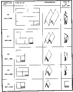 |
Plan sizes in excess of the AO size will be permitted if they are some multiple of the dimensions of the A4 size. Plan dimensions shown for all sheet sizes represent the distance from trim line to trim line in both directions. The border line for the plan will be at least 10 mm inside the trim line on all four sides.