| This consolidation is unofficial and is for reference only. For the official version of the regulations, consult the original documents on file with the Office of the Registrar of Regulations, or refer to the Royal Gazette Part II. |
| Regulations are amended frequently. Please check the list of Regulations by Act to see if there are any recent amendments to these regulations filed with our office that are not yet included in this consolidation. |
| Although every effort has been made to ensure the accuracy of this electronic version, the Office of the Registrar of Regulations assumes no responsibility for any discrepancies that may have resulted from reformatting. |
| This electronic version is copyright © , Province of Nova Scotia, all rights reserved. It is for your personal use and may not be copied for the purposes of resale in this or any other form. |
Road Trails Designation
made under subsections 37(1) and (3) of the
Road Trails Act
S.N.S. 2023, c. 4
N.S. Reg. 2/2025 (effective January 7, 2025)
N.S. Reg. 123/2025 (effective June 25, 2025)
Table of Contents
Please note: this table of contents is provided for convenience of reference and does not form part of the regulations.
Click here to go to the text of the regulations.
Schedule “A”: Location of Designated Road Trails
Appendix A: Trunk 7 Sherbrooke Village Inn
Appendix H: Mountain Road, St. Peters
Appendix I: Capelin Cove, Richmond County
Appendix J: Doucetteville, Digby County
Appendix K: Framboise, Richmond County
Appendix L: Hospital Road (Sherbrooke, Guysborough County)
Appendix M: Mooseland, Halifax Regional Municipality
Appendix N: Riversdale, Colchester County
Appendix O: Kemptown, Colchester County
Appendix P: Route 308 (Tusket, Yarmouth County)
Appendix Q: Lennox Passage, Richmond County
Appendix R: Margaree Centre, Inverness County
Appendix S: Beech Hill Road, Queens County
Appendix T: Summerville, Queens County
Appendix U: Bloomfield Cross Road, Digby County
Appendix V: Pubnico, Yarmouth County
Appendix W: Churchover, Shelburne County
Appendix X: Port Clyde, Shelburne County
Appendix Y: Spa Road, Shelburne County
Schedule “A” Location of Designated Road Trails
Appendix Z: St. Peter’s, Richmond County
Appendix AA: Thibeauville, Richmond County
Appendix AB: Balmoral, Richmond County
Appendix AC: Cleveland, Richmond County
Appendix AD: Bridgetown, Annapolis County
Appendix AE: Conway, Digby County
Appendix AF: Lequille, Annapolis County
Appendix AG: Nictaux, Annapolis County
Appendix AH: Port Hilford, Guysborough County
Appendix AI: Sherbrooke, Guysborough County
Appendix AJ: Devon, Halifax Regional Municipality
Appendix AK: Guysborough, Guysborough County
Appendix AL: Isaacs Harbour, Guysborough County
Appendix AM: Dean, Halifax Regional Municipality
Appendix AN: Moser River, Halifax Regional Municipality
Appendix AO: Marshy Hope, Pictou County
Appendix AP: Thorburn, Pictou County (Thorburn Road)
Appendix AQ: Pugwash, Cumberland County
Appendix AR: Maccan, Cumberland County
Appendix AS: Birchtown, Shelburne County
Appendix AT: Mira Gut, Cape Breton Regional Municipality
Appendix AU: Wallace, Cumberland County
I, Fred Tilley, Minister of Public Works for the Province of Nova Scotia, pursuant to subsections 37(1) and (3) of Chapter 4 of the Acts of 2023, the Road Trails Act, hereby
(a) repeal the designation of road trails, N.S. Reg. 176/2023, made by the Minister of Public Works by order dated September 27, 2023; and
(b) designate portions of public highways located on lands owned by His Majesty the King in Right of the Province of Nova Scotia, under the administration and control of the Minister of Public Works, at various locations in the Province of Nova Scotia shown in bold line on the maps attached in Schedule “A” as road trails for the purpose of the Road Trails Act.
This order is effective on and after the date it is filed.
Dated and made January 7, 2025, at Halifax Regional Municipality, Province of Nova Scotia.
sgd. Fred Tilley
Honourable Fred Tilley
Minister of Public Works
Schedule “A”: Location of Designated Road Trails
Coordinates are decimal degrees map coordinates taken from Google Earth.
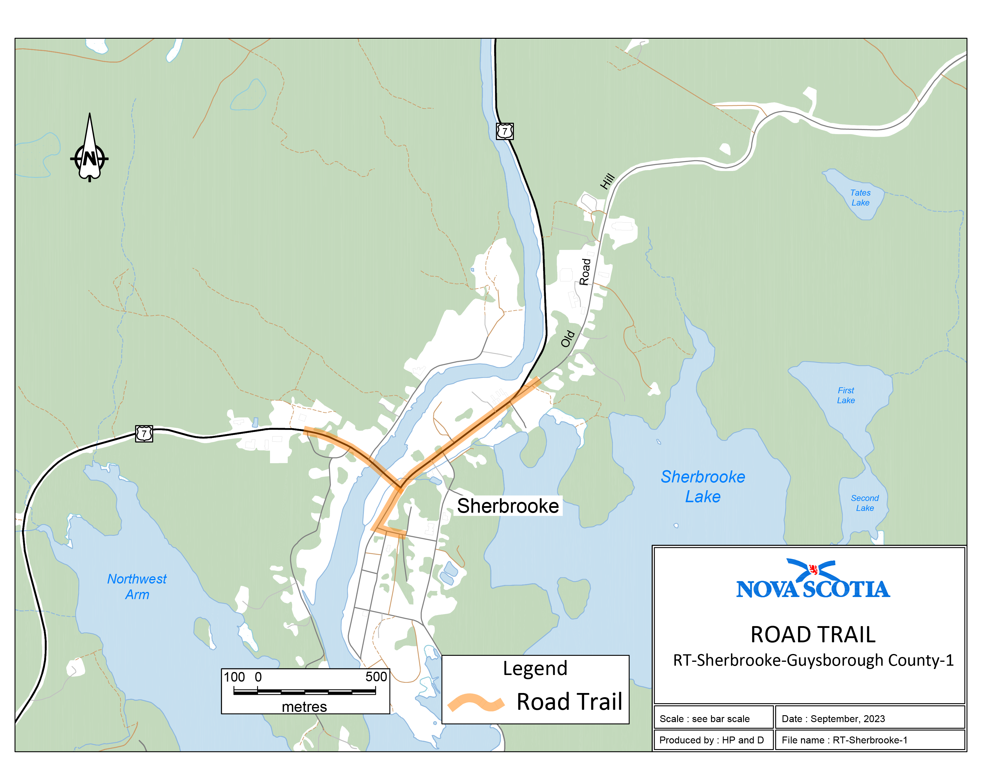
Appendix A: Trunk 7 Sherbrooke Village Inn
Two sections of road travel:
1. The road trail intersects with Highway 7 near Sherbrooke, Guysborough County, at coordinates 45.144697°N, 61.988007°W and travels in an easterly direction along Highway 7 for 830 m to the intersection of Highway 7 and Main Street. The road trail then travels northeast for 635 m to the intersection of Highway 7 and Old Road Hill. The road trail then travels northeast along Old Road Hill for 100 m to the intersection of Old Road Hill and the existing trail to coordinates 45.1465781°N, 61.975474°W.
2. The road trail begins at the intersection of Highway 7 and Main Street and travels southwest along Main Street to the intersection of Main Street and Court Street. The road trail then travels east along Court Street for 90 m from the intersection of Main Street and Court Street to coordinates 45.140585°N, 61.982679°W.
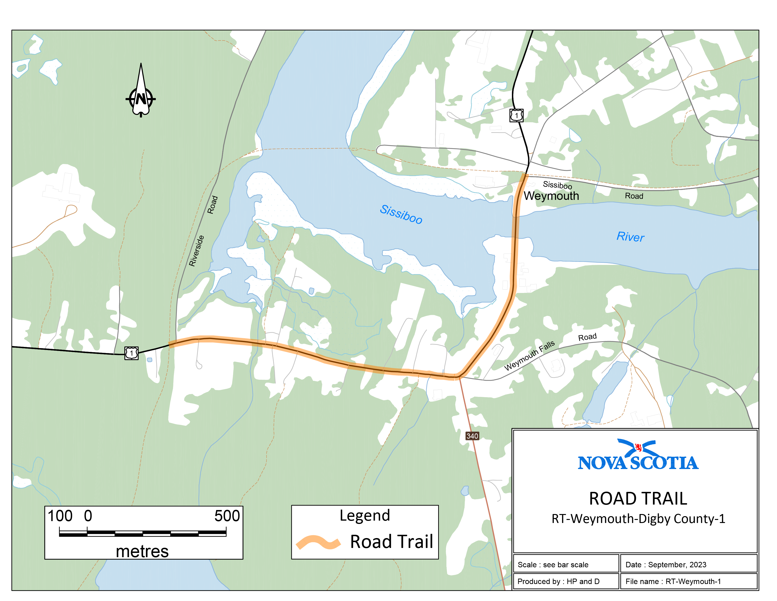
Trail begins where the former rail bed intersects with Highway 1, north of Weymouth, Digby County, at coordinates 44.405798°N, 66.011676°W. Then 810 m along Highway 1 to the intersection of Route 340, Weymouth Falls Road and Highway 1. Then westerly, 1060 m along Highway 1 to the intersection of existing trail on [the] former rail bed at coordinates 44.411654°N, 65.995797°W.
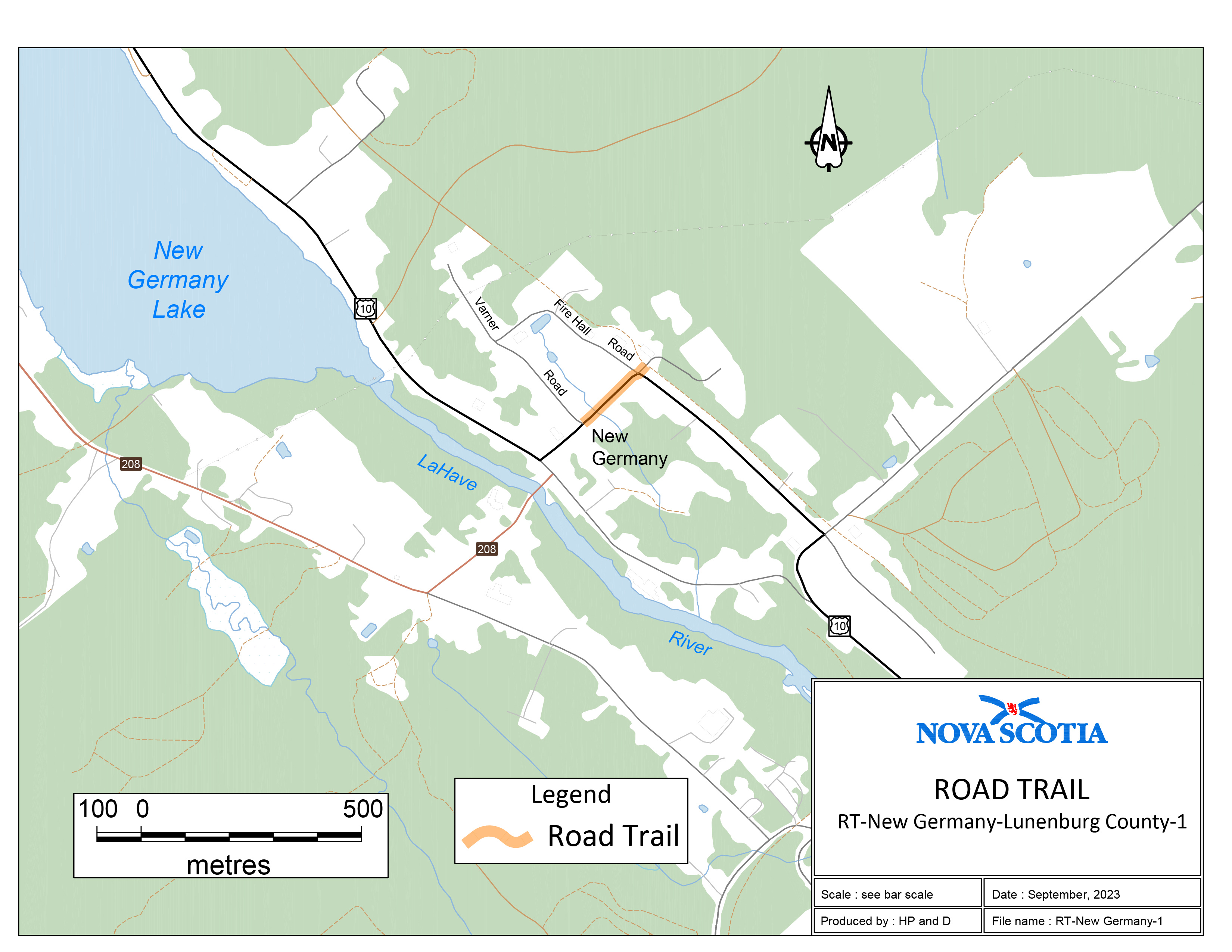
Trail begins where the former rail bed intersects with Maple Drive, New Germany (near Fire Hall), Lunenburg County, at coordinates 44.547502°N, 64.722695°W. Then southwest crossing Highway 10 and travelling 210 m to the intersection of Highway 10 and Varner Road at coordinates 44.546265°N, 64.724589°W.
Beginning at a point on the Myra Road, Porters Lake, Halifax County, coordinates 44.808262°N, 63.385073°W and travelling in a northerly direction for 110 m to an existing trail at 44.809038°N, 63.384350°W.

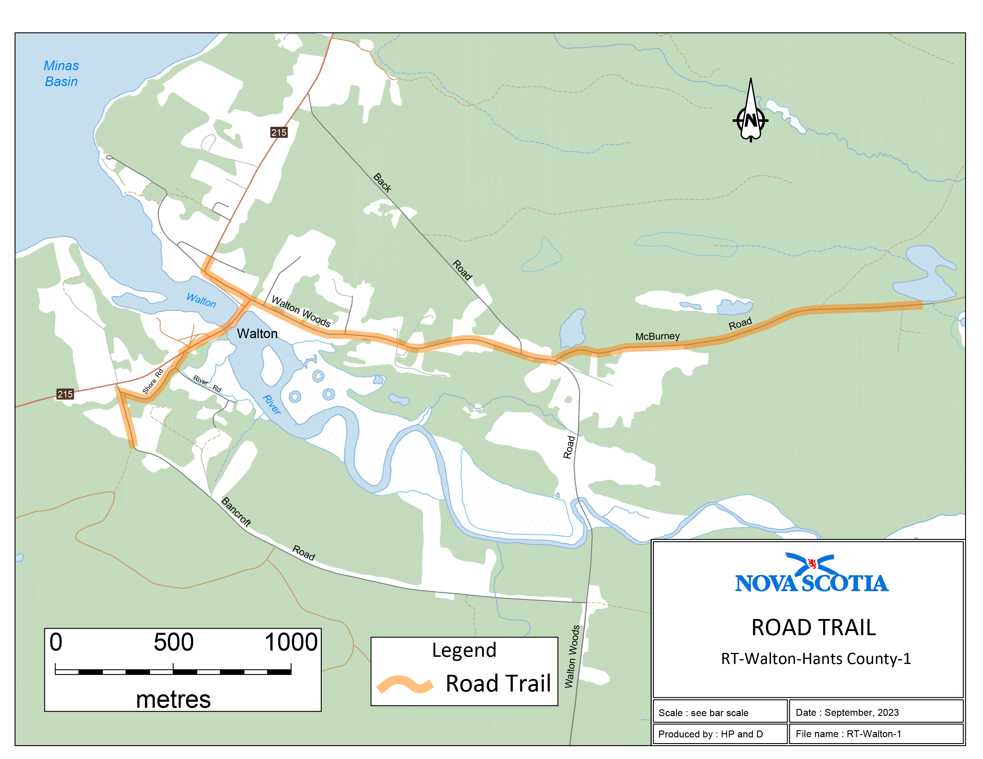
Two sections of road travel:
1. Trail intersects with the Bancroft Road near Walton, Hants County, at coordinates 45.223205°N, 64.010301°W. Then north 250 m, along the Bancroft Road to the intersection of the Shore Road, then 375 m along the Shore Road to the intersection of Route 215. Then northeast along Route 215, 365 m to the intersection of the Walton Woods Road. Then easterly along the Walton Woods Road 1340 m to the intersection of the McBurney Road, then 1600 m along McBurney Road to coordinates 45.228497°N, 63.967040°W.
2. Beginning at the intersection of Route 215 and Walton Woods Road, then northwest along Route 215, 290 m to the intersection of Route 215 and Odd Fellows Hall Road, coordinates 45.230406°N, 64.006121°W.
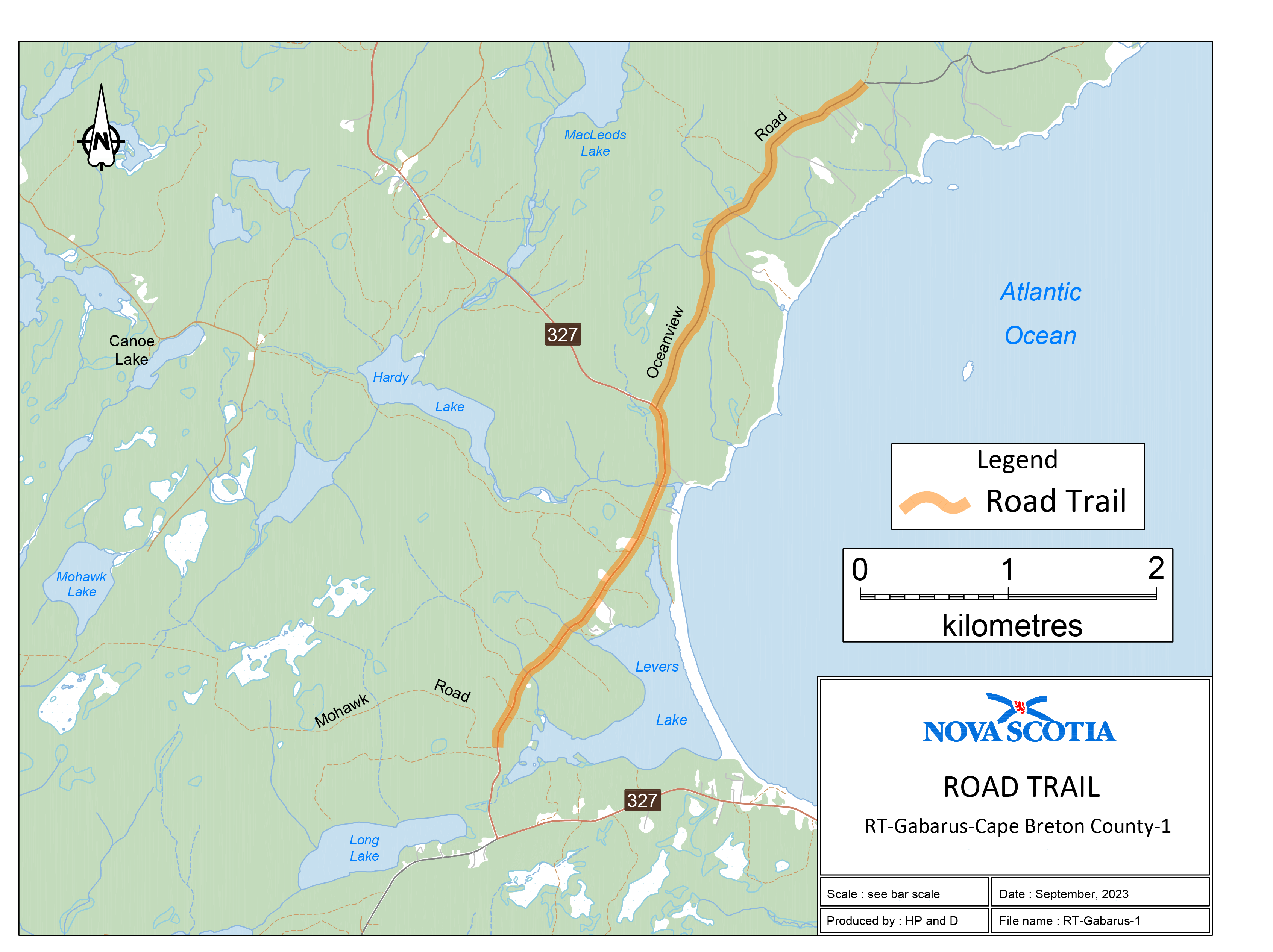
Trail begins where a K-class road intersects with Oceanview Road at 45.882330°N, 60.156693°W, and travelling in a southerly direction along Oceanview Road, 2822 m to the intersection of Oceanview Road and Route 327. Then southerly along Route 327, 2667 m to the intersection of Route 327 and a Crown road (Mohawk Road) at 45.842191°N, 60.189473°W.
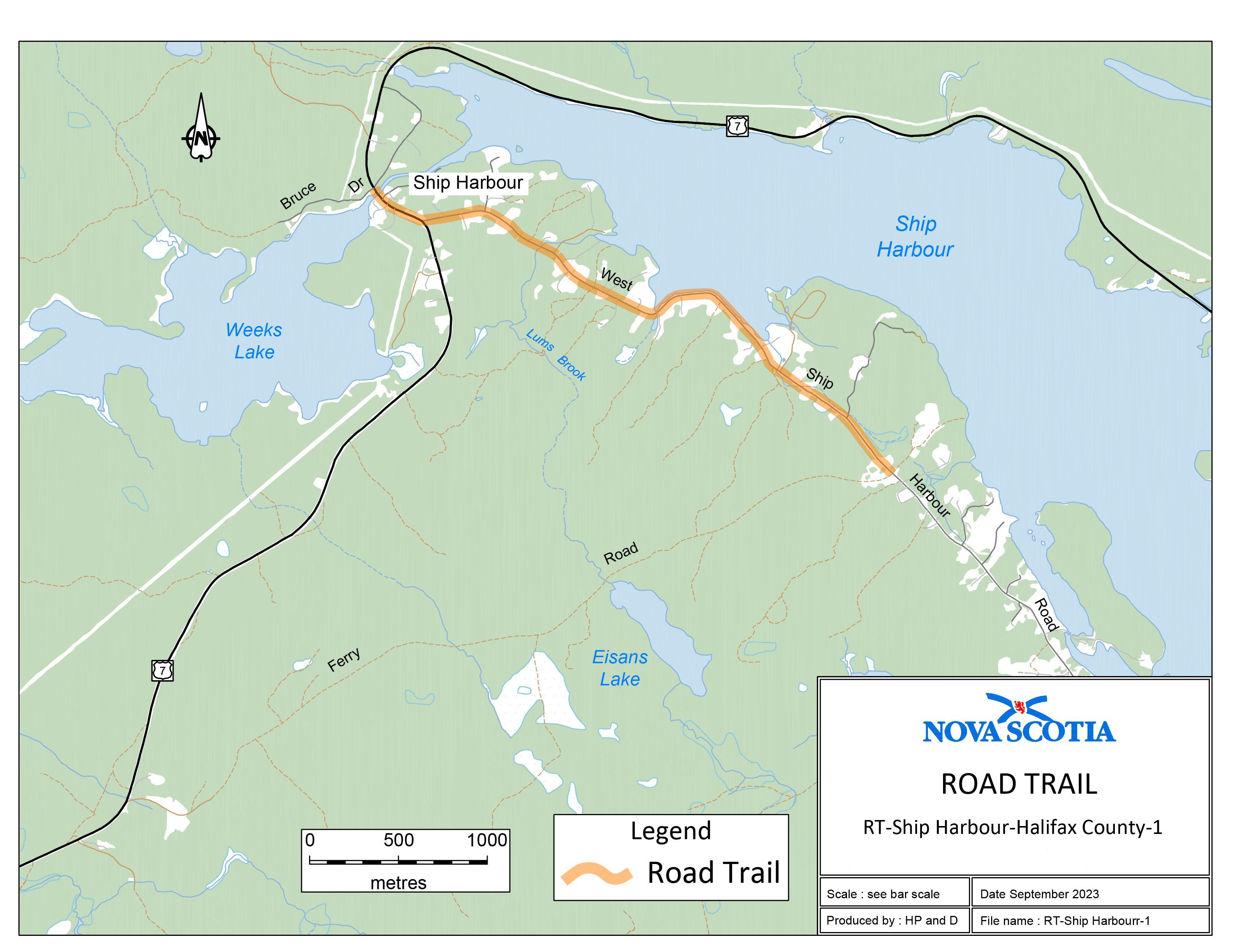
Trail begins at the location where Ferry Road (K-class road) intersects with West Ship Harbour Road at coordinates 44.795386°N, 62.848750°W. Then 3300 m in a northwesterly direction along West Ship Harbour Road and Trunk 7. Then 340 m northwesterly along Trunk 7 to the intersection of Trunk 7 and Bruce Drive (a private lane) at coordinates 44.809451°N, 62.886036°W.
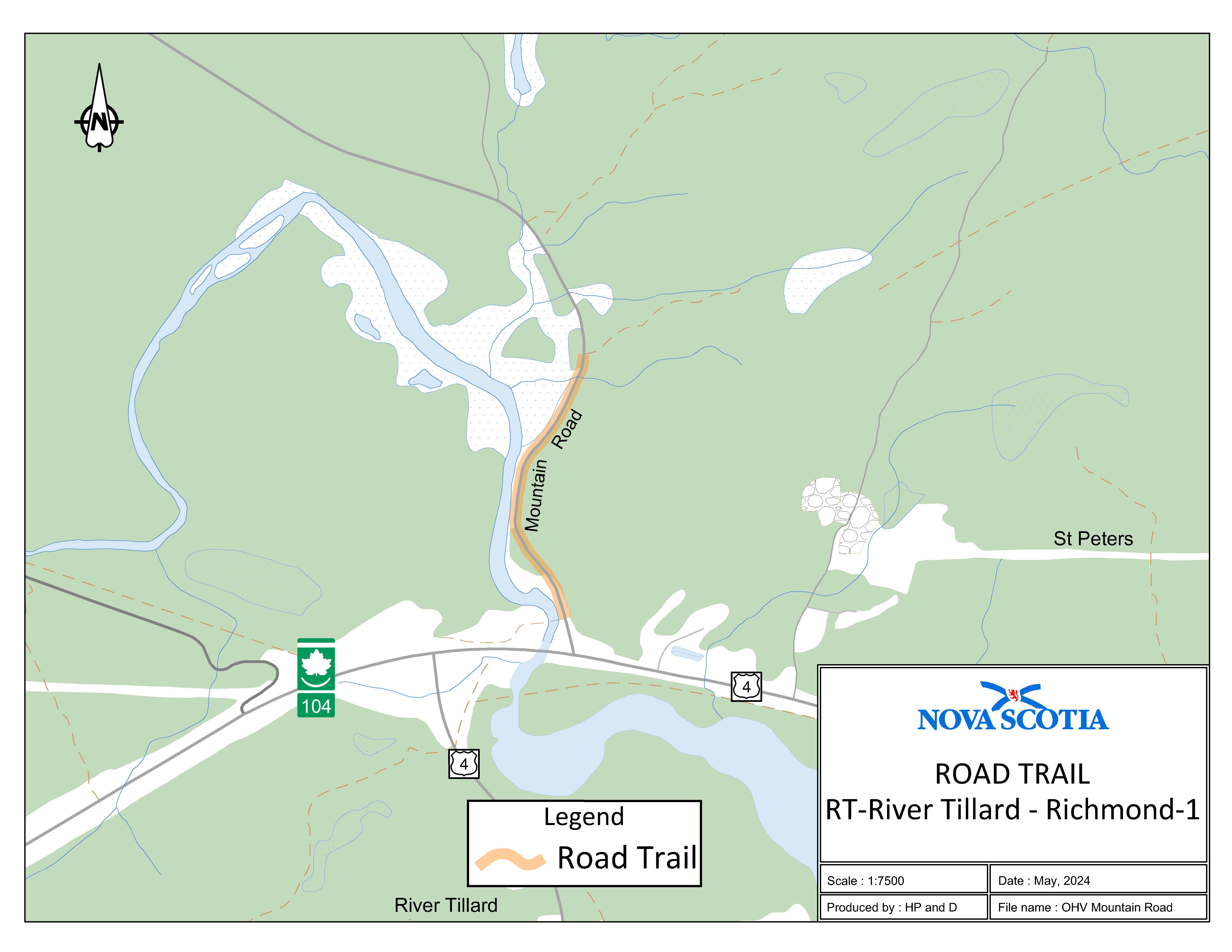
Appendix H: Mountain Road, St. Peters
The road trail begins at the intersection of the rail trail and Mountain Road, a gravel road with an unposted speed limit of 80 km/h, at coordinates 45.657544°N, 60.912829°W, and travels south along Mountain Road for 0.53 km to the intersection of Mountain Road and Trail 62.
Appendix I: Capelin Cove, Richmond County
The road trail begins at the intersection of St. Peters Fourchu Road and the Capelin Cove Road Trailhead at coordinates 45.686306°N, 60.448473°W and travels east on St. Peters Fourchu Road for 3.25 km to the intersection of St. Peters Fourchu Road and the St. Esprit Road Trailhead.
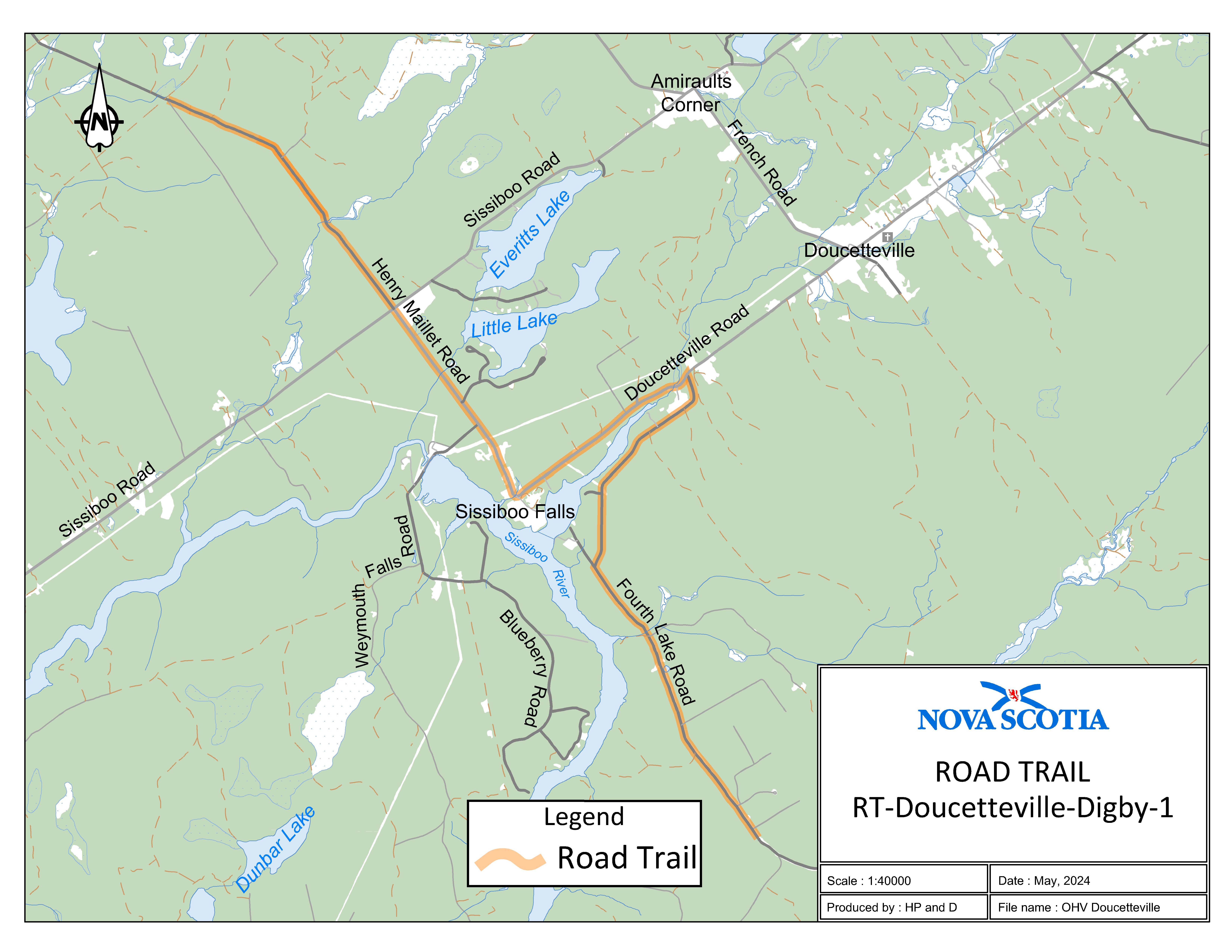
Appendix J: Doucetteville, Digby County
Three sections of road travel:
1. The road trail begins at the intersection of Henry Maillet Road and the rail trail at coordinates 44.459454°N, 65.902948°W and travels 2.9 km on Henry Maillet Road to the intersection of Henry Maillet Road and Sissiboo Road. The road trail continues on Henry Maillet Road from the intersection of Henry Maillet Road and Sissiboo Road and travels 2.04 km to the intersection of Henry Maillet Road and Doucetteville Road.
2. The road trail continues on Doucetteville Road from the intersection of Henry Maillet Road and Doucetteville Road and travels 1.9 km to the intersection of Doucetteville Road and Fourth Lake Road.
3. The road trail continues on Fourth Lake Road from the intersection of Doucetteville Road and Fourth Lake Road and travels 5.05 km to the end of Fourth Lake Road to coordinates 44.400604°N, 65.834440°W.
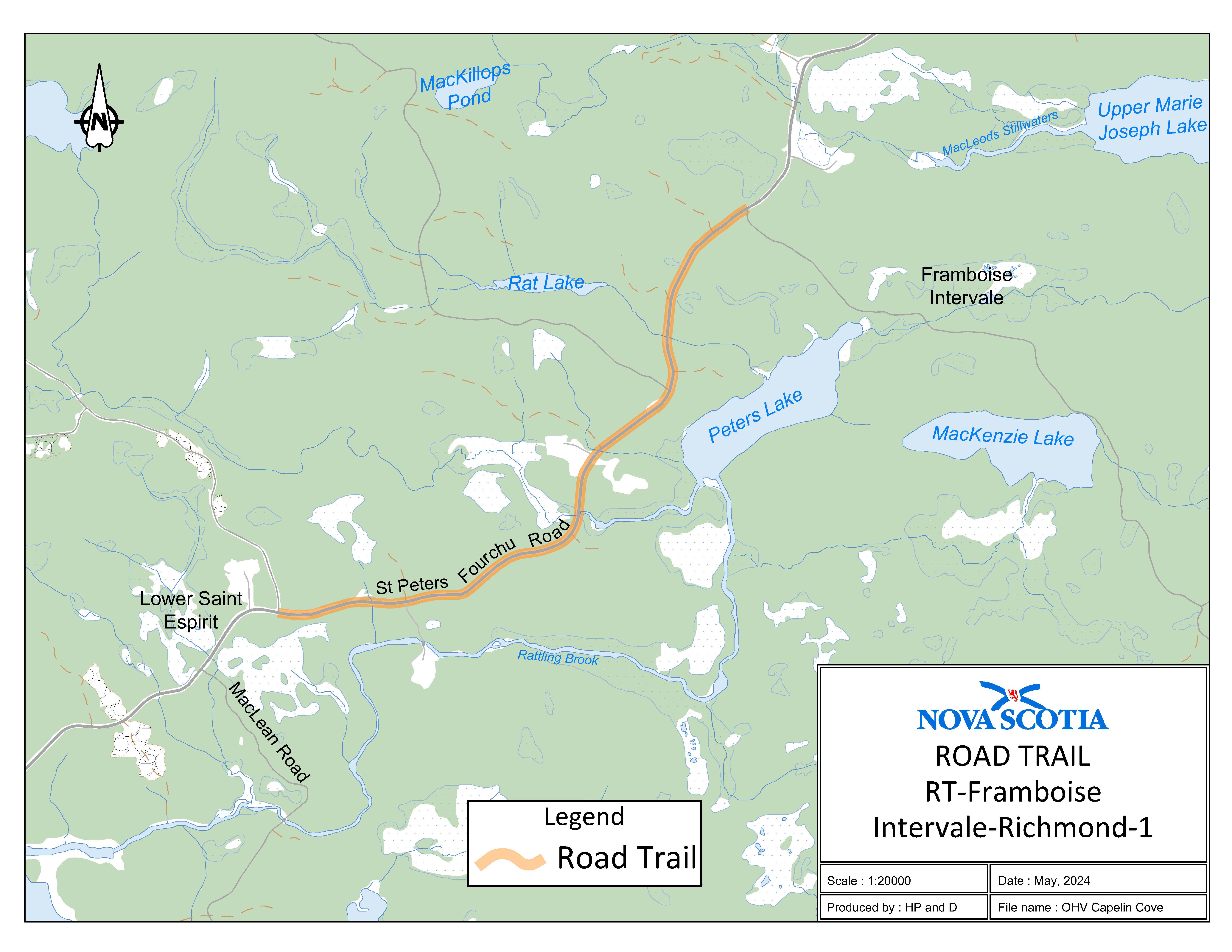
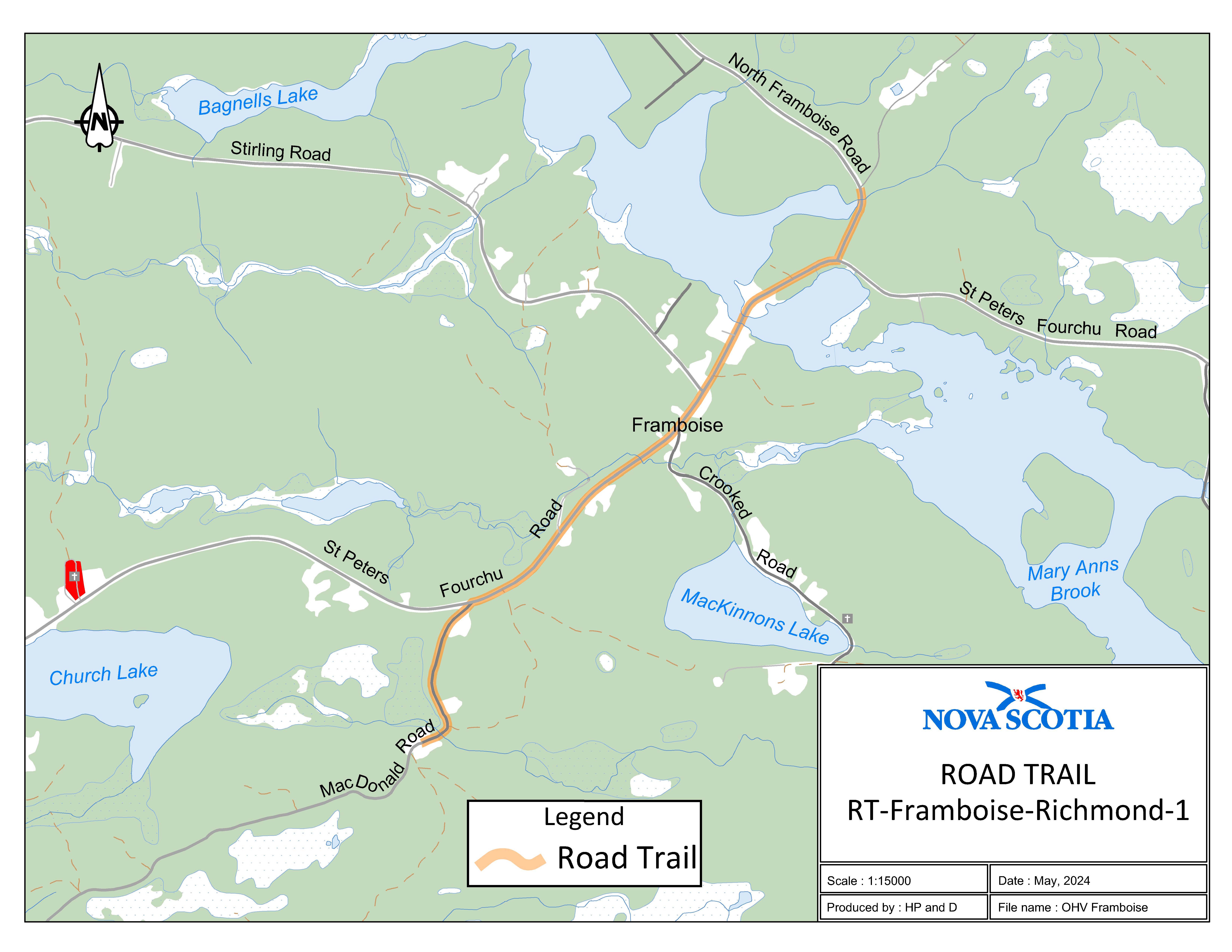
Appendix K: Framboise, Richmond County
Three sections of road travel:
1. The road trail begins on MacDonald Road at coordinates 45.709206°N, 60.375196°W and travels north on MacDonald Road for 0.64 km to the intersection of MacDonald Road and St. Peters Fourchu Road.
2. The road trail continues on St. Peters Fourchu Road from the intersection of St. Peters Fourchu Road and MacDonald Road and travels for 1.75 km to the intersection of St. Peters Fourchu Road and North Framboise Road.
3. The road trail continues on North Framboise Road from the intersection of St. Peters Fourchu Road and North Framboise Road and travels north for 0.27 km to the intersection of North Framboise Road and Trail 652 at coordinates 45.726071°N, 60.355583°W.
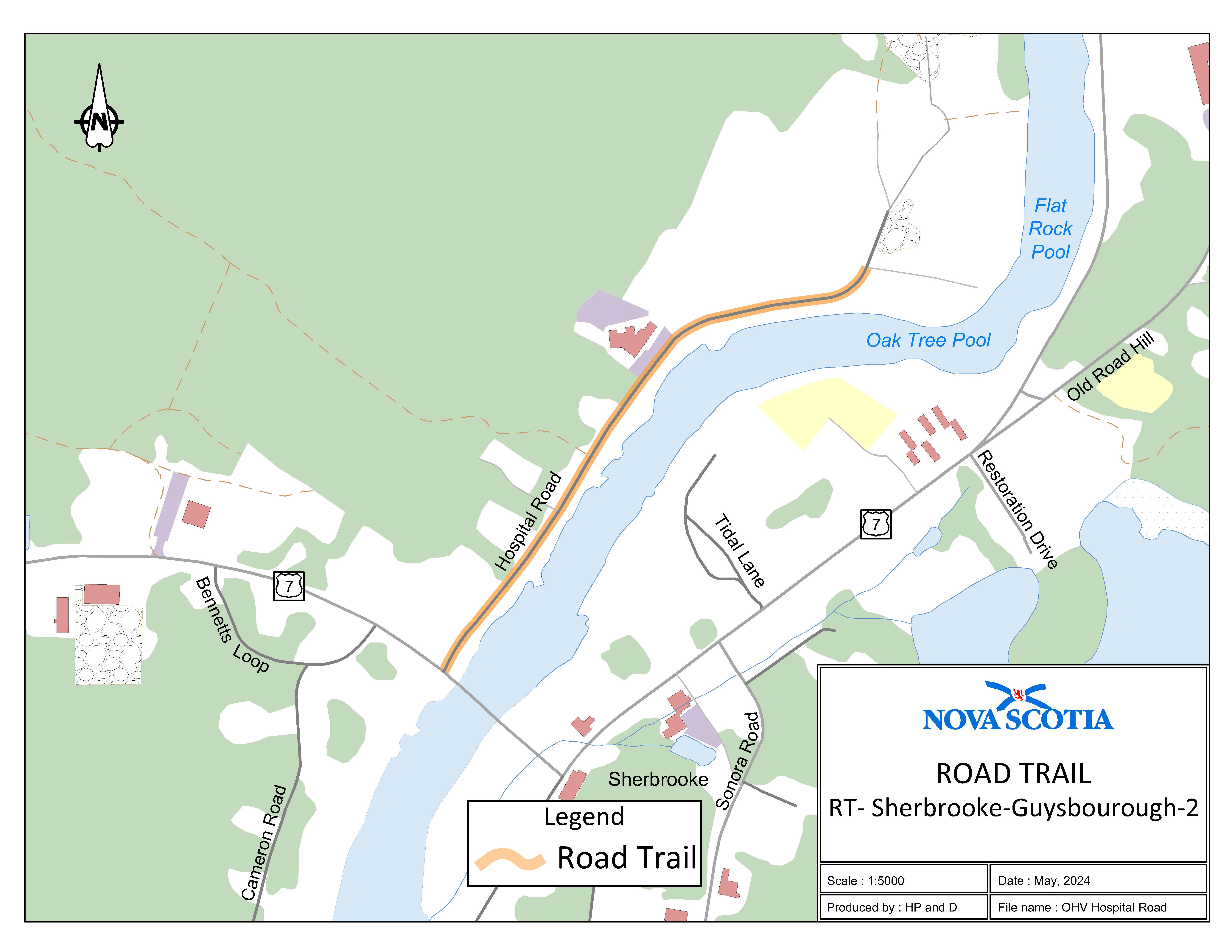
Appendix L: Hospital Road (Sherbrooke, Guysborough County)
The road trail begins at the intersection of Hospital Road and Trunk 7 at coordinates 45.143579°N, 61.984493°W and travels 0.8 km to civic number 150 Hospital Road.
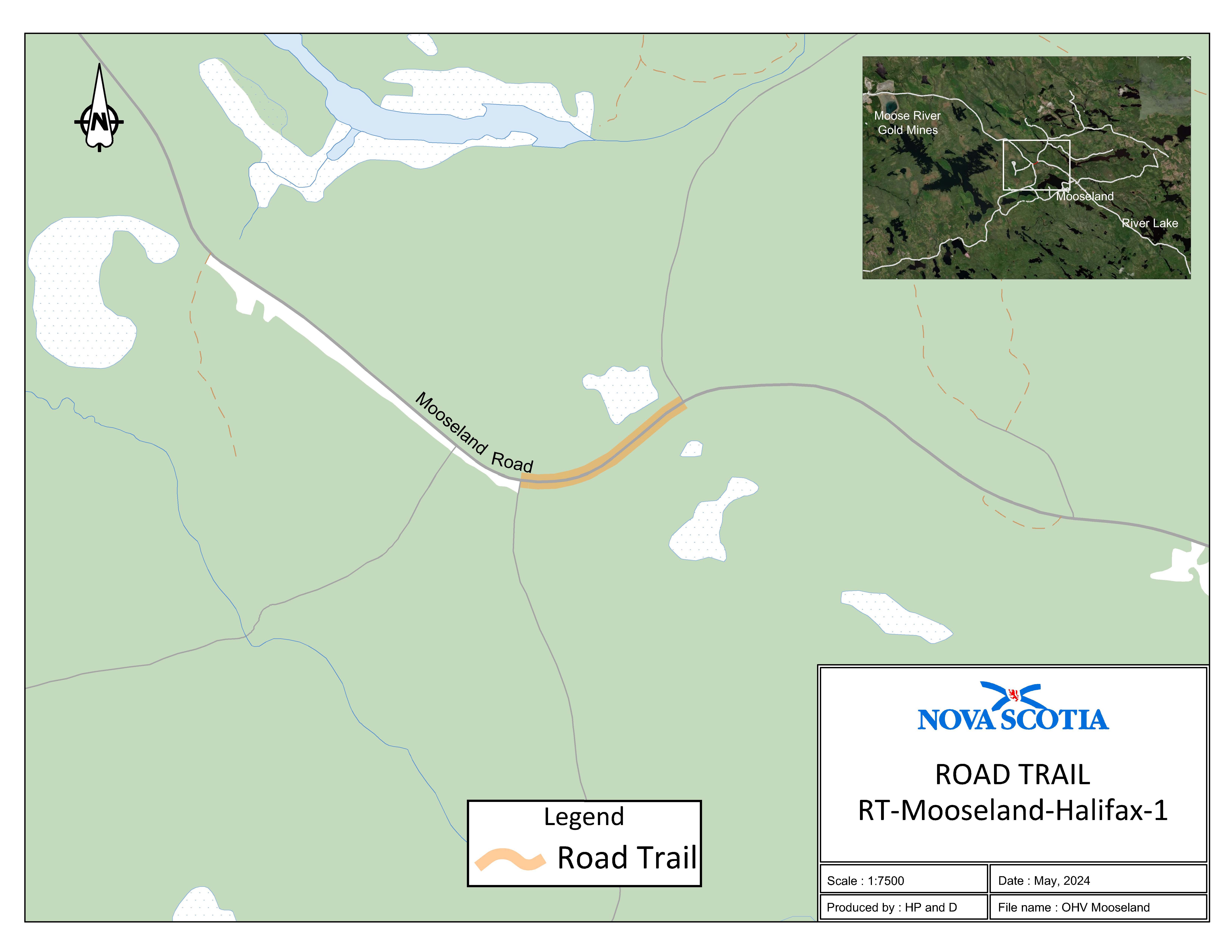
Appendix M: Mooseland, Halifax Regional Municipality
The road trail begins at the intersection of Trail 105 and Mooseland Road, Halifax County, at coordinates 44.955069°N, 62.820712°W and travels north on Mooseland Road for 0.3 km to the intersection of Mooseland Road and Trail 106 at coordinates 44.953820°N, 62.824220°W.
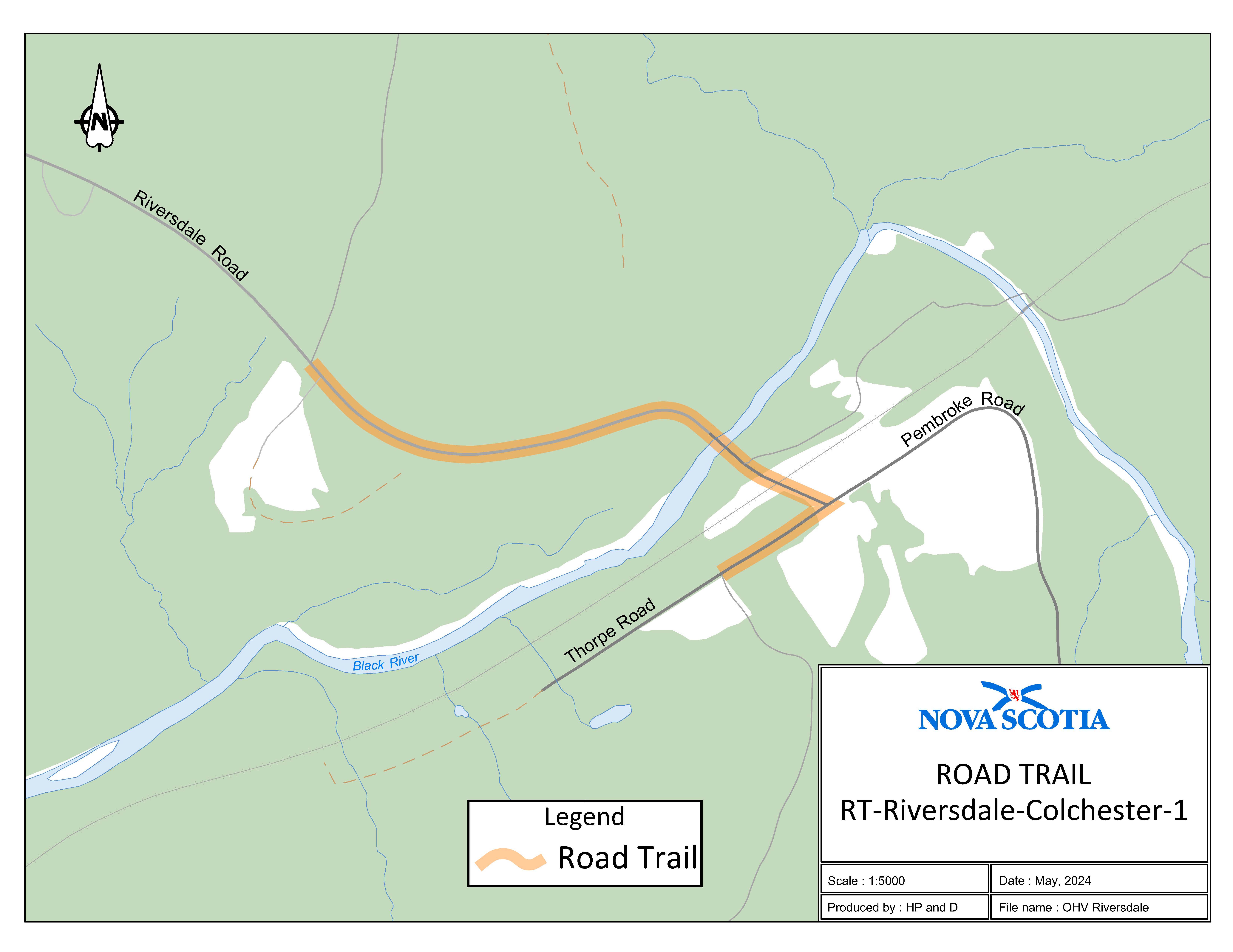
Appendix N: Riversdale, Colchester County
Two sections of road travel:
1. The road trail begins at the intersection of Riversdale Road and Trail 104 at coordinates 45.424525°N, 63.052559°W and travels northeast for 0.66 km to the intersection of Riversdale Road and Thorpe Road.
2. The road trail continues on Thorpe Road from the intersection of Thorpe Road and Riversdale Road and travels southwest for 0.15 km to the intersection of Thorpe Road and Trail 496 at coordinates 45.422343°N, 63.046667°W.
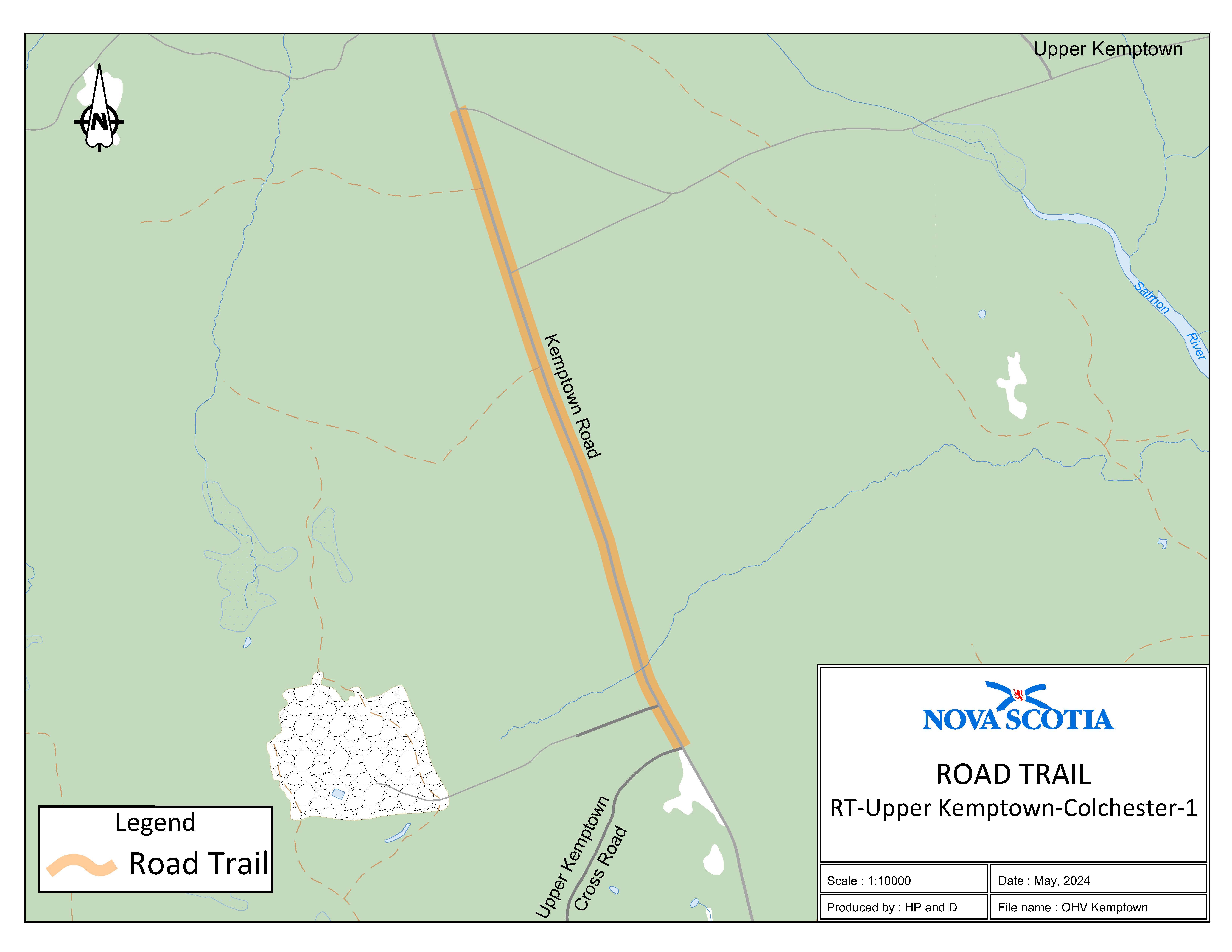
Appendix O: Kemptown, Colchester County
The road trail begins at the intersection of Kemptown Road and Upper Kemptown Cross Road at coordinates 45.525926°N, 63.107645°W and travels north on Kempton Road for 1.55 km to the intersection of Kempton Road and Trail 104 Trailhead at coordinates 45.539069°N, 63.113812°W.
Appendix P: Route 308 (Tusket, Yarmouth County)
The road trail begins at civic number 4023 on Route 308 at coordinates 43.862052°N, 65.972857°W and travels north on Route 308 for 0.55 km to civic number 4137 on Route 308. The road trail then connects to the rail trail.

Appendix Q: Lennox Passage, Richmond County
The road trail begins at the intersection of the Richmond County Rail Trail and Route 320 at coordinates 45.620859°N, 61.060233°W and travels south to the Louisdale Connector for a distance of 3.36 km. The road trail continues on Route 320 from the Louisdale Connector to Route 206 for a distance of 4.33 km. The road trail continues on Route 206 from Route 320 to Rogers Road for a distance of 0.13 km. The road trail continues on Rogers Road from Route 206 to Rogers Road (K section) for a distance of 0.37 km.

Appendix R: Margaree Centre, Inverness County
The road trail begins at civic number 27 Cranton Crossing Road at coordinates 46.342057°N, 60.995968°W and travels north for a distance of 0.64 km. The road trail continues on West Big Intervale Road from the intersection of Cranton Crossing Road and West Big Intervale Road until civic number 1316 West Big Intervale Road at coordinates 46.339900°N, 61.017156°W for a distance of 1.6 km.

Appendix S: Beech Hill Road, Queens County
The road trail begins adjacent to civic number 115 on Beech Hill Road at coordinates 43.957777°N, 64.775868°W and travels northwest through the Highway 103 underpass and terminates at the Queens County Rail Trail on Crown land at coordinates 43.985066°N, 64.794630°W. The total distance is 3.84 km.

Appendix T: Summerville, Queens County
The road trail begins at the intersection of Trunk 3 and Old Port Mouton Road (K-class road) at coordinates 43.957833°N, 64.828901°W and travels southeast for a distance of 1.5 km. The road trail continues on River Head Road from the intersection of River Head Road and Trunk 3 until adjacent to civic number 203 River Head Road at coordinates 43.940081°N, 64.828697°W for a distance of 1.1 km.

Appendix U: Bloomfield Cross Road, Digby County
The road trail begins adjacent to civic number 478 Bloomfield Road at coordinates 44.527923°N, 65.824999°W. It then turns on to Bloomfield Cross Road and travels southeast for a distance of 0.99 km. The road trail continues on Ridge Road from the intersection of Bloomfield Cross Road and Ridge Road and ends at coordinates 44.520031°N, 65.813272°W for a distance of 0.1 km.

Appendix V: Pubnico, Yarmouth County
The road trail begins on Trunk 3 adjacent to Cunningham Road at coordinates 43.703757°N, 65.780940°W and goes easterly on Trunk 3 for a distance of 0.45 km.

Appendix W: Churchover, Shelburne County
The road trail begins at the intersection of Boulder Cove Road and Shore Road at coordinates 43.727899°N, 65.379813°W and goes southeast on Shore Road for a distance of 0.96 km. The road trail continues on Shore Road where it meets Gouldens Road at coordinates 43.722814°N, 65.370528°W and continues on Gouldens Road going southeast for a distance of 0.15 km. The road trail goes from where Gouldens Road meets Old Shore Road at coordinates 43.720804°N, 65.370969°W and then continues on Old Shore Road for a distance of 0.35 km. The road trail goes from where Old Shore Road meets Shore Road and then continues on Shore Road for a distance of 0.9 km.

Appendix X: Port Clyde, Shelburne County
The road trail begins at the intersection of Route 309 (Port LaTour Road) and Lyle Road at coordinates 43.600270°N, 65.469576°W and goes northeast on Route 309 for a distance of 0.60 km. The road trail follows Route 309 where it intersects with Shore Road at coordinates 43.605088°N, 65.467771°W and continues on Shore Road going southeast for a distance of 1.36 km. The road trail intersects with Greenwood Road at coordinates 43.598507°N, 65.454502°W and then continues on Greenwood Road for a distance of 1.65 km. The road trail continues on Shore Road for a distance of 0.56 km.

Appendix Y: Spa Road, Shelburne County
The road trail begins at the end of the municipal section of Spa Road and goes southeast on Spa Road until it meets the Shelburne County Rail Trail at coordinates 43.764943°N, 65.301209°W for a distance of 0.32 km.

I, Fred Tilley, Minister of Public Works for the Province of Nova Scotia, pursuant to subsections 37(1) and (3) of Chapter 4 of the Acts of 2023, the Road Trails Act, hereby designate portions of public highways located on lands owned by His Majesty the King in Right of the Province of Nova Scotia, and under the administration and control of the Minister of Public Works, at various locations in the Province of Nova Scotia as described in and as shown in bold lines on the maps attached in Schedule “A” as road trails for the purpose of the Road Trails Act.
This order is effective on and after the date it is filed with the Registrar of Regulations.
Dated and made June 25, 2025, at Halifax Regional Municipality, Province of Nova Scotia.
sgd. Fred Tilley
Honourable Fred Tilley
Minister of Public Works
Schedule “A”
Location of Designated Road Trails
Coordinates are decimal degrees map coordinates taken from Google Earth.
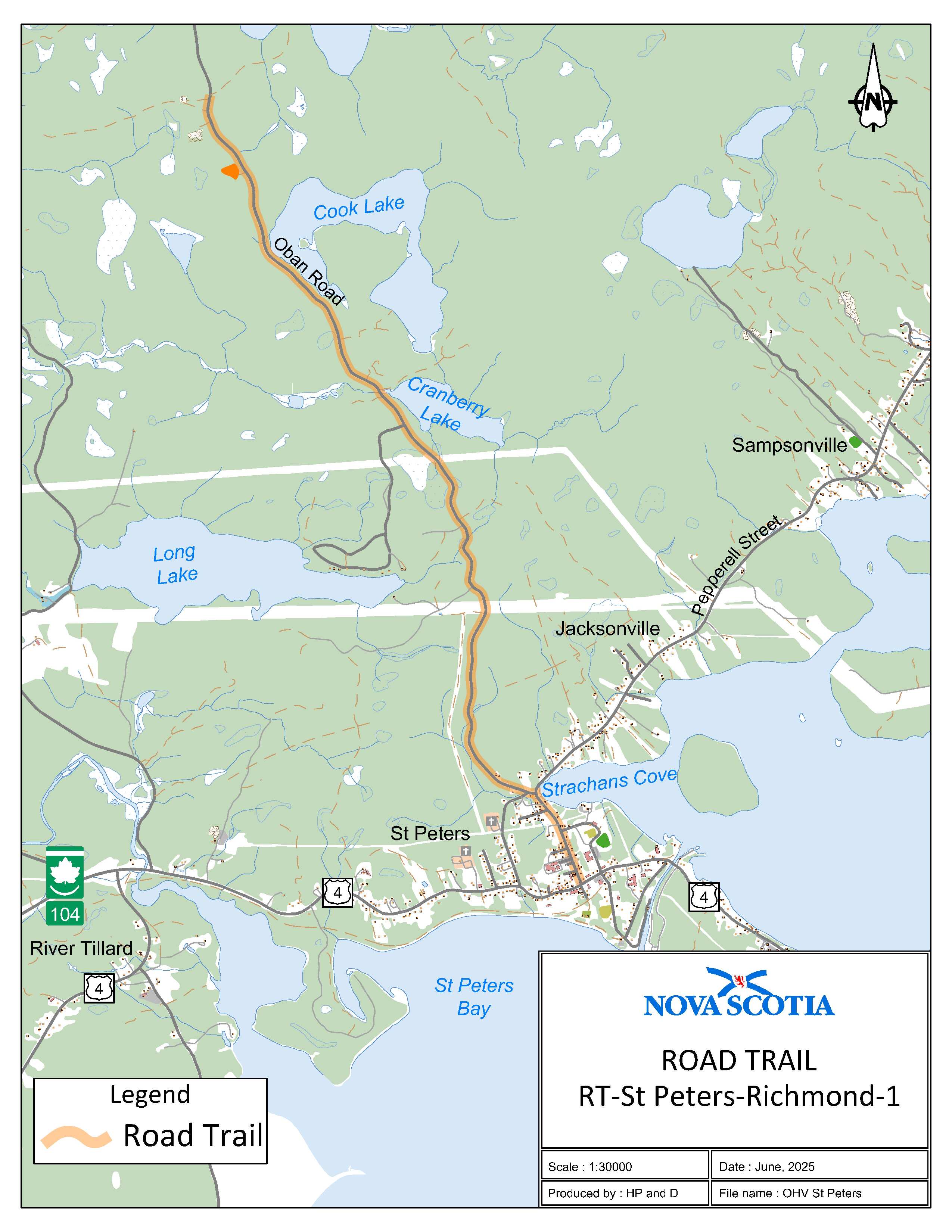
Appendix Z: St. Peter’s, Richmond County
The road trail begins 0.9 km south of civic 297 Oban Road on a forestry road on the Department of Natural Resources property at coordinates 45.704490°N, 60.906975°W and goes south for 5.75 km. The road trail continues on Pepperell Street for 0.70 km to the intersection of Pepperell Street and Granville Street in St. Peter’s.
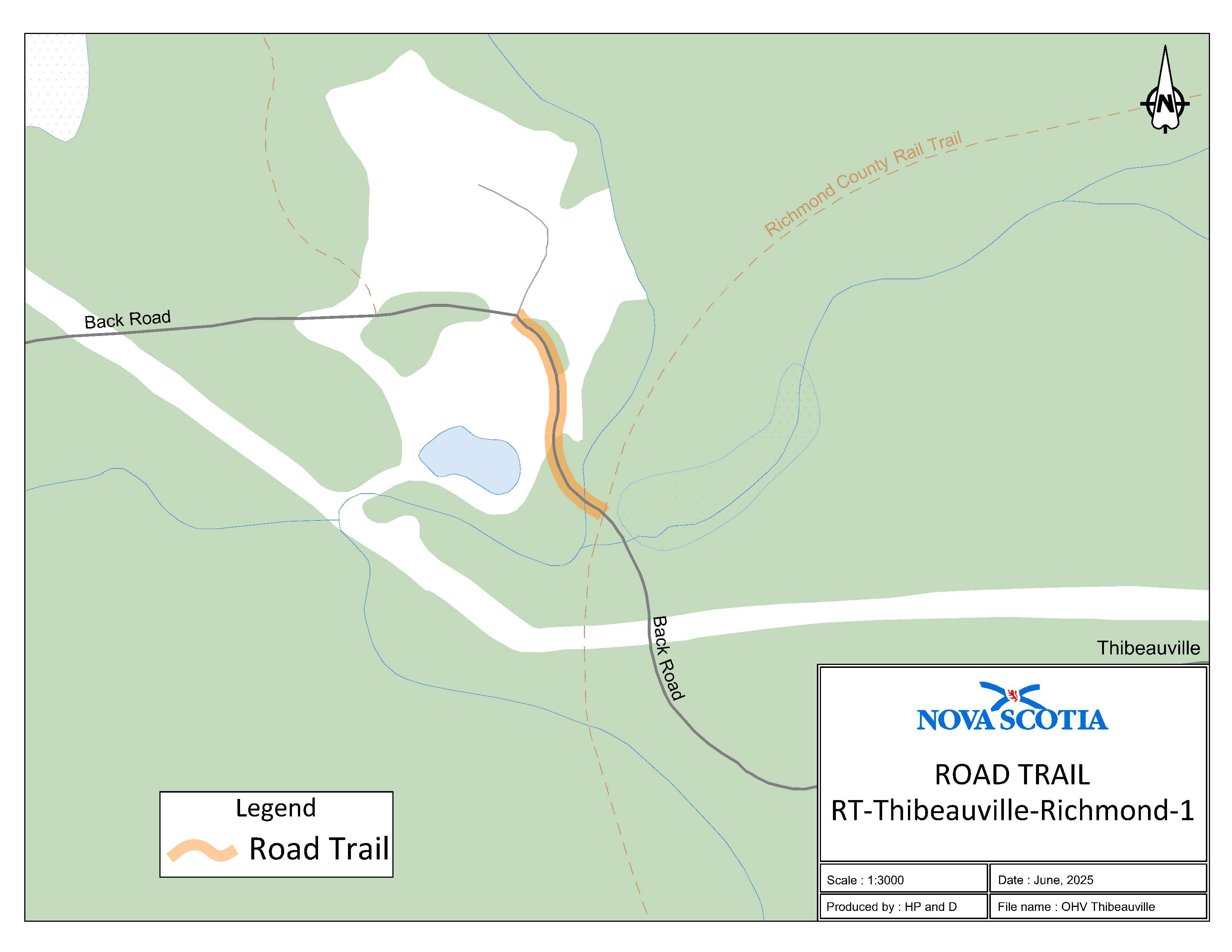
Appendix AA: Thibeauville, Richmond County
The road trail begins adjacent to 1520 Back Road at coordinates 45.660440°N, 61.010230°W and goes southeast on Black Road for 0.16 km.
Appendix AB: Balmoral, Richmond County
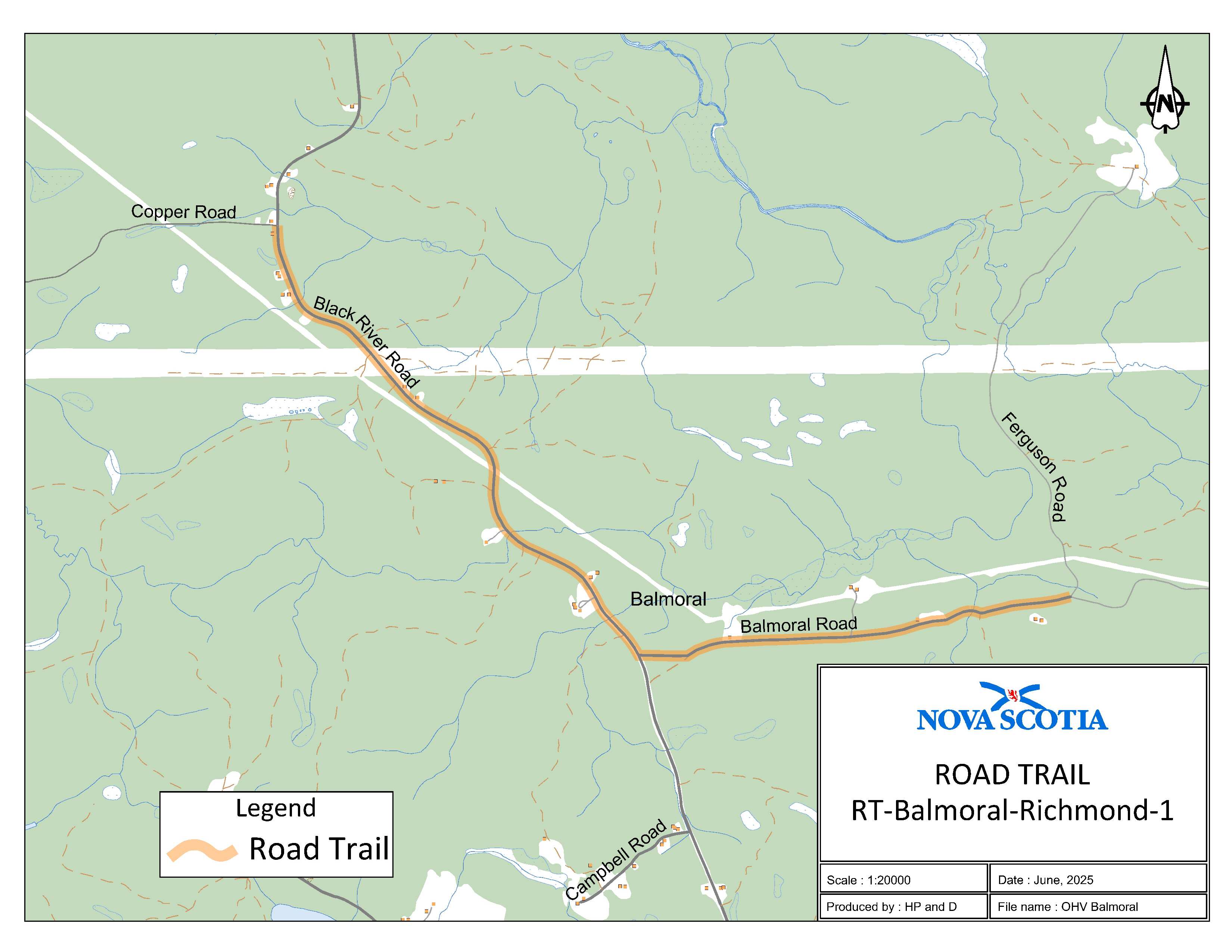
The road trail begins at the intersection of Cooper Road and Black River Road at coordinates 45.676463°N, 61.107757°W and goes southeast on Black River Road for 2.7 km. The road trail continues east on Balmoral Road for 2 km where Balmoral Road intersects with the K-class road at coordinates 45.661217°N, 61.061682°W.
Appendix AC: Cleveland, Richmond County
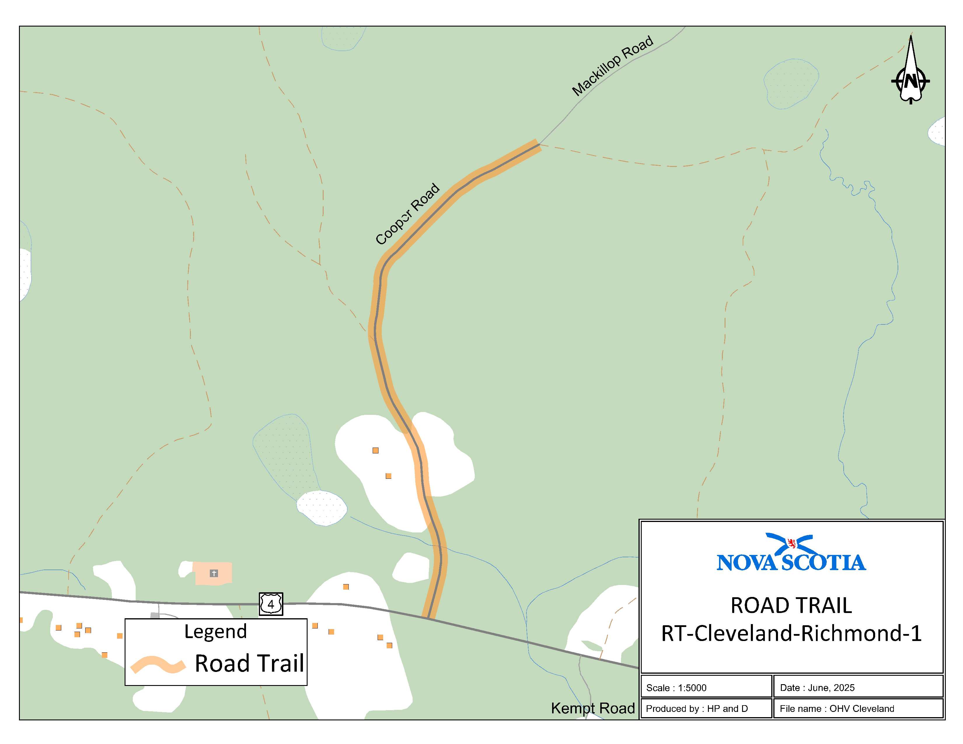
The road trail begins where the I-class section of Coopers Road intersects the K-class section of Coopers Road at coordinates 45.664273°N, 61.171958°W and continues south on Cooper Road for 0.82 km to the intersection of Cooper Road and Trunk 4.
Appendix AD: Bridgetown, Annapolis County
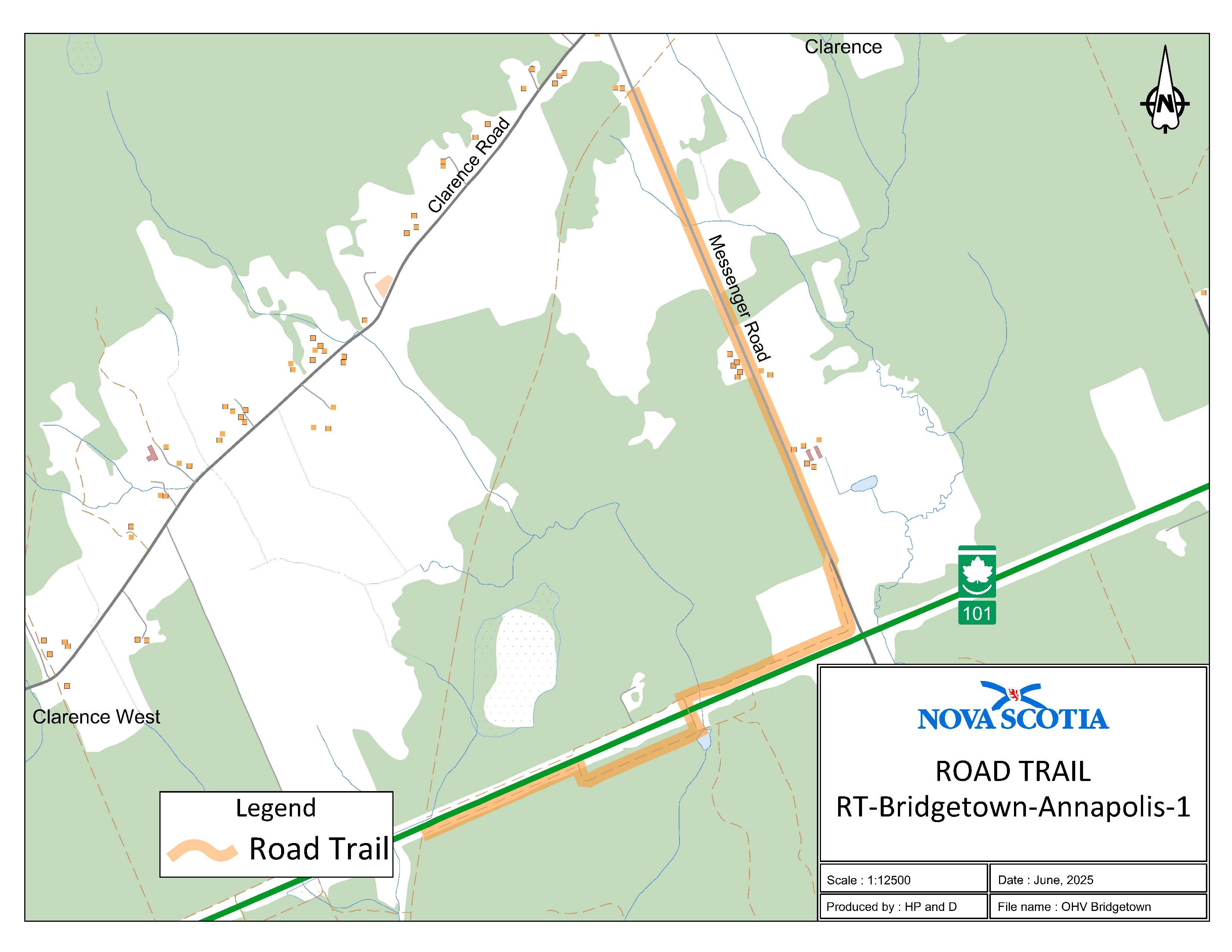
The road trail begins adjacent to civic 478 Messenger Road at coordinates 44.887546°N, 65.253985°W and goes southeast for 4.15 km. The road trail continues south on the service road adjacent to Highway 101 for 0.75 km and then goes under Highway 101 via a large culvert in a southeast direction and then continues south on another service road adjacent to Highway 101 for 0.87 km where it meets the OHV trail at coordinates 44.848839°N, 65.266682°W.
Appendix AE: Conway, Digby County
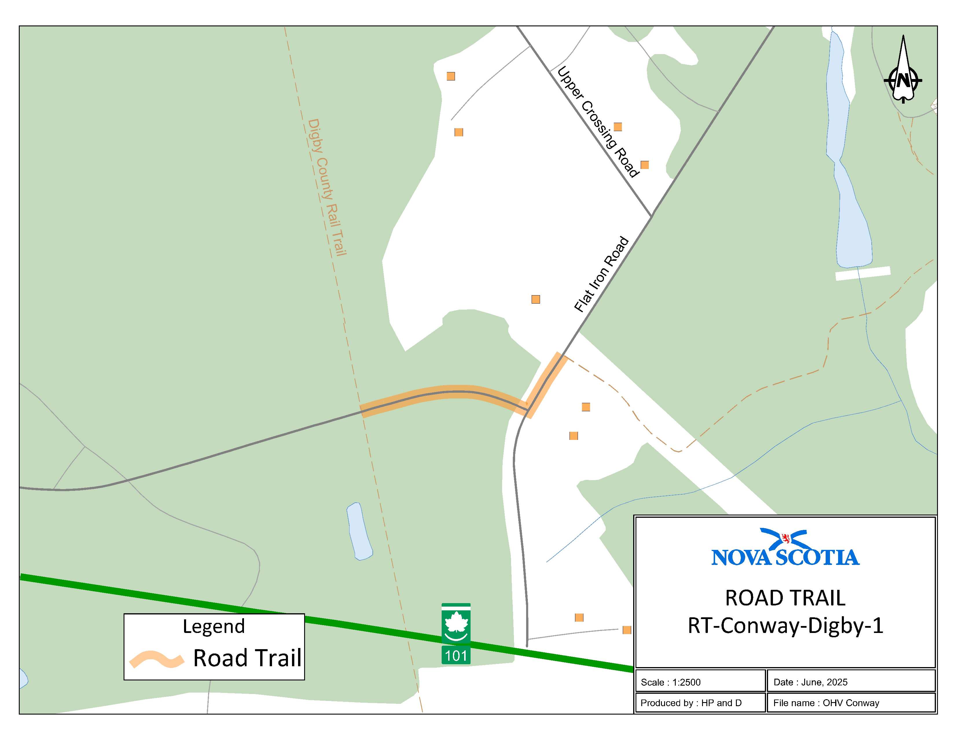
The road trail begins at the intersection of Rail Trail and Service Road at coordinates 44.599444°N, 65.779803°W and goes east for 0.12 km. The road trail continues on Flat Iron Road to a trailhead adjacent to 48 Flat Iron Road at coordinates 44.599821°N, 65.777928°W.
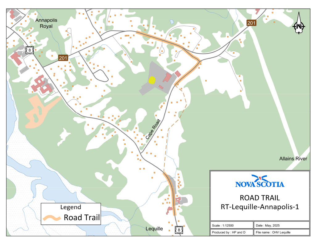
Appendix AF: Lequille, Annapolis County
Part 1:
The road trail begins adjacent to civic 117 on Route 201 at coordinates 44.737966, 65.493715°W and goes east for 0.22 km. The road trail continues south on Cape Road for 0.29 km which ends at coordinates 44.733989°N, 65.491509°W.
Part 2:
The road trail continues southeast on Trunk 8 from adjacent to civic 9589 at coordinates 44.731375°N, 65.492050°W for 0.25 km.
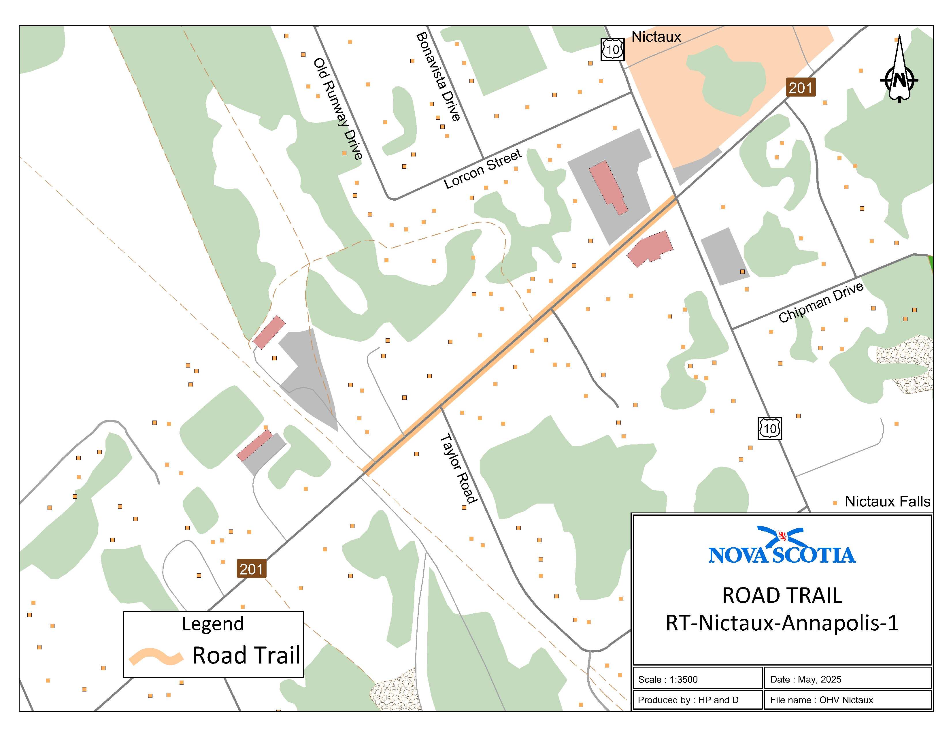
Appendix AG: Nictaux, Annapolis County
The road trail begins at where the trailhead intersects at [with] Route 201 at civic 8751 at coordinates 44.924105°N, 65.052448°W and goes northeast for 0.4 km to the intersection of Trunk 10 and Route 201.
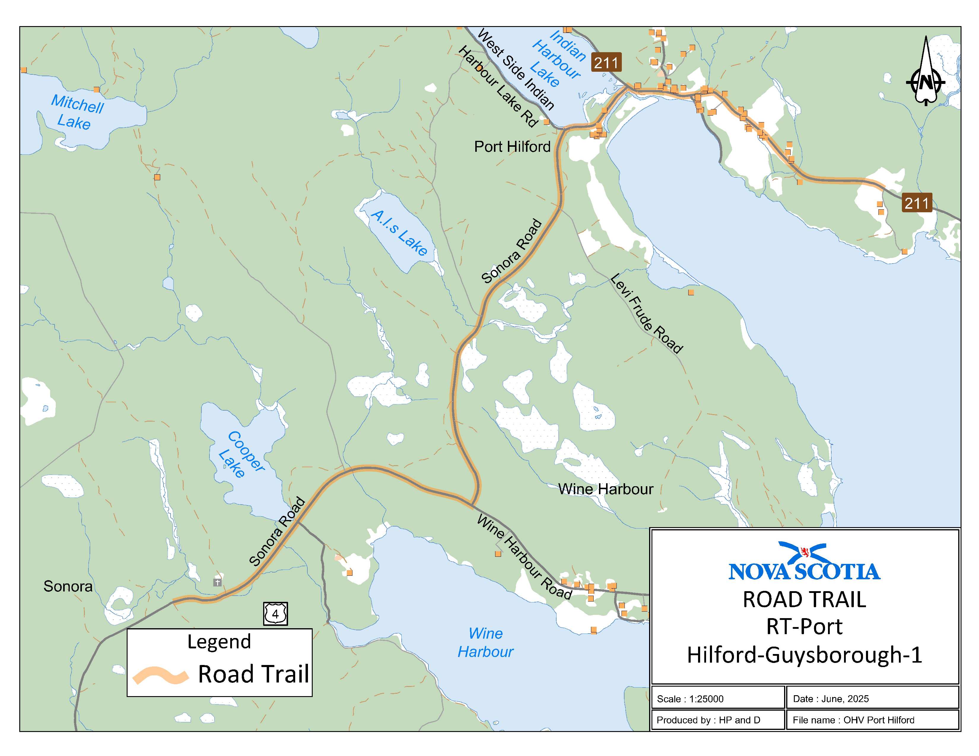
Appendix AH: Port Hilford, Guysborough County
The road trail begins at [the] intersection at the end of Trail 512B and Sonora Road at coordinates 45.074729°N, 61.886626°W and goea [goes] northeast for 6.13 km. The road trail continues on Route 211 and heads east for 1.12 km and ends at coordinates 45.104790°N, 61.833066°W.
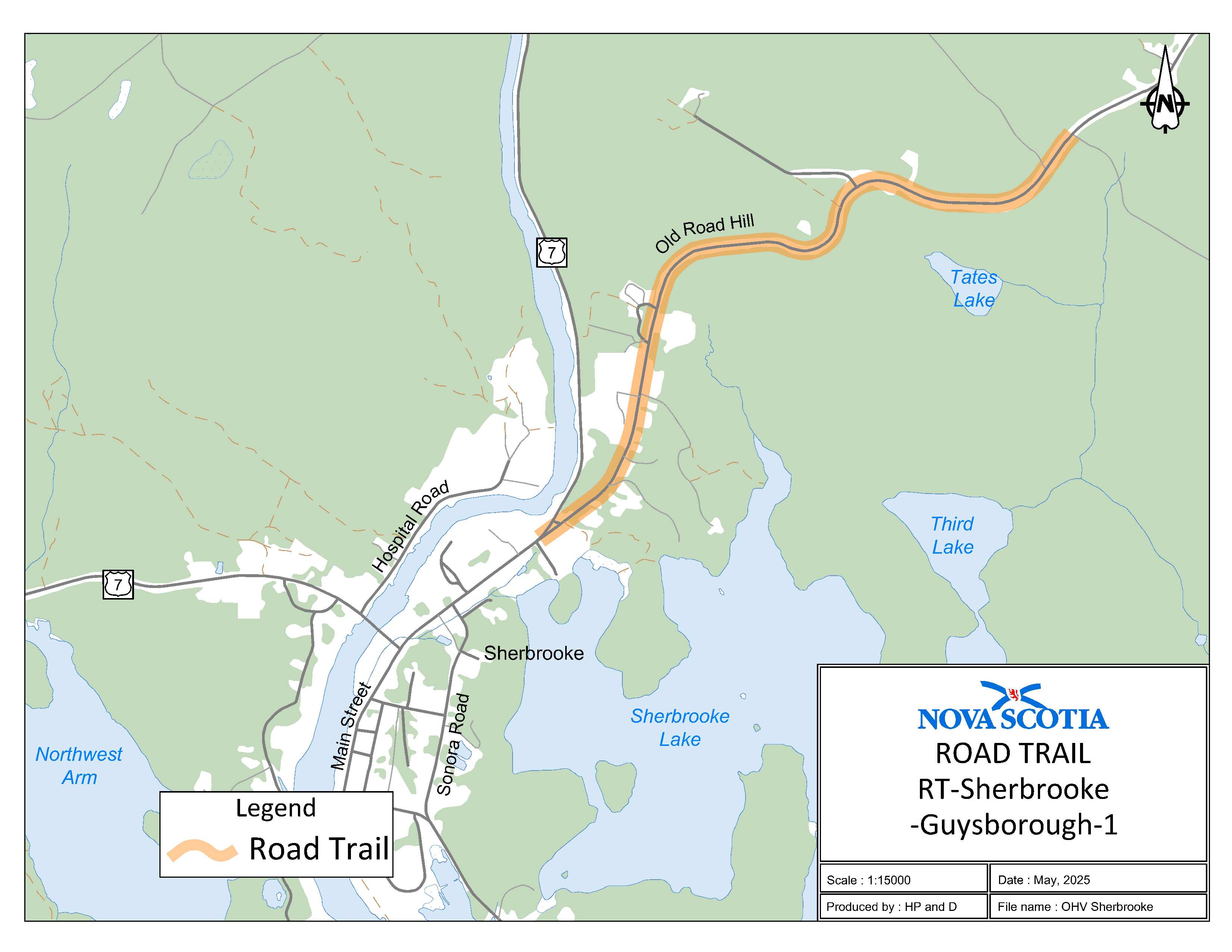
Appendix AI: Sherbrooke, Guysborough County
The road trail begins at the intersection of Old Road Hill and Trunk 7 at coordinates 45.145807°N, 61.976769°W and goes northeast on Old Road Hill for 2.7 km and ends at coordinates 45.158333°N, 61.953776°W.
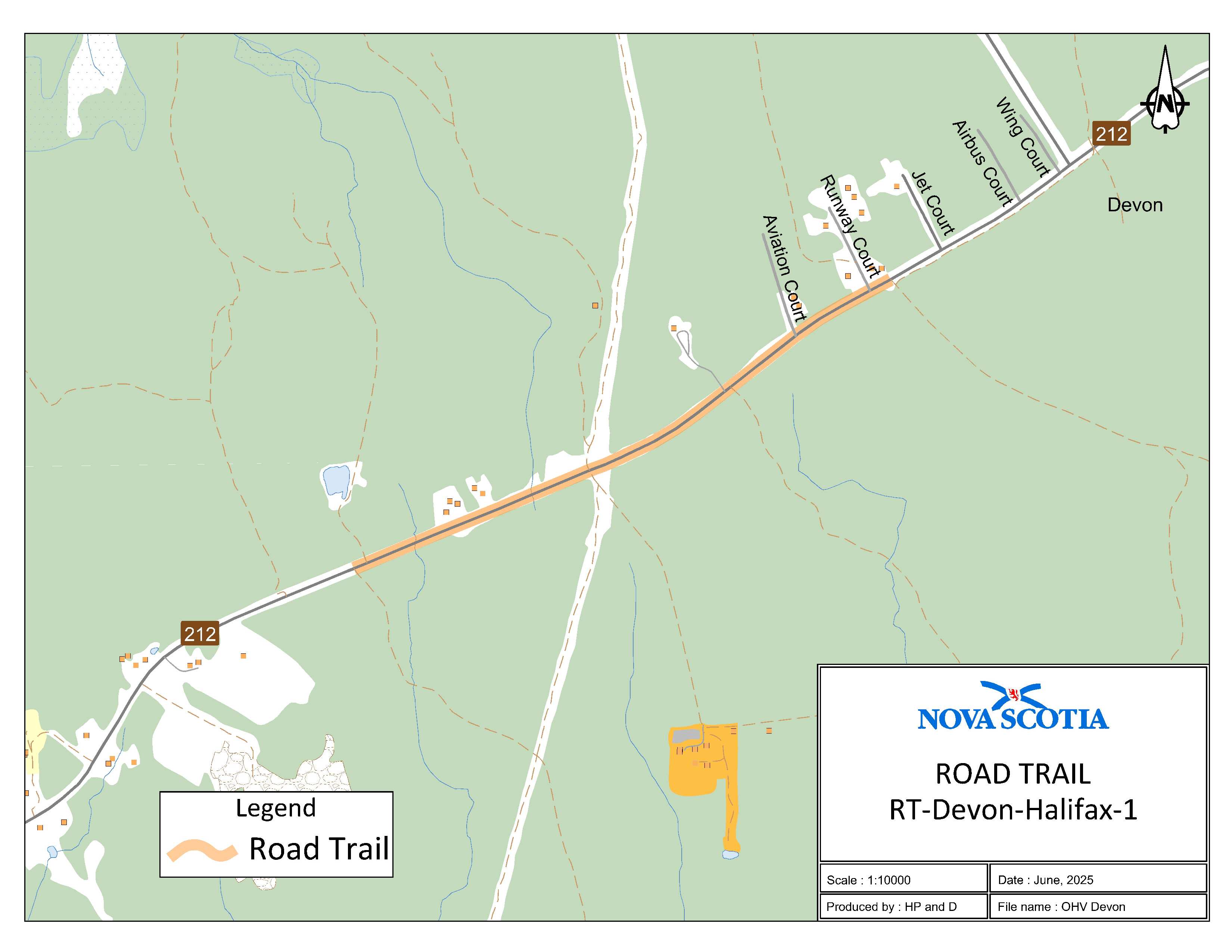
Appendix AJ: Devon, Halifax Regional Municipality
The road trail begins on Route 212 at coordinates 44.8977874°N, 63.445872°W at [and] goes east for 1.39 km. The road trail ends adjacent to civic address 11 Runway Court in Devon at coordinates 44.903600°N, 63.430474°W.
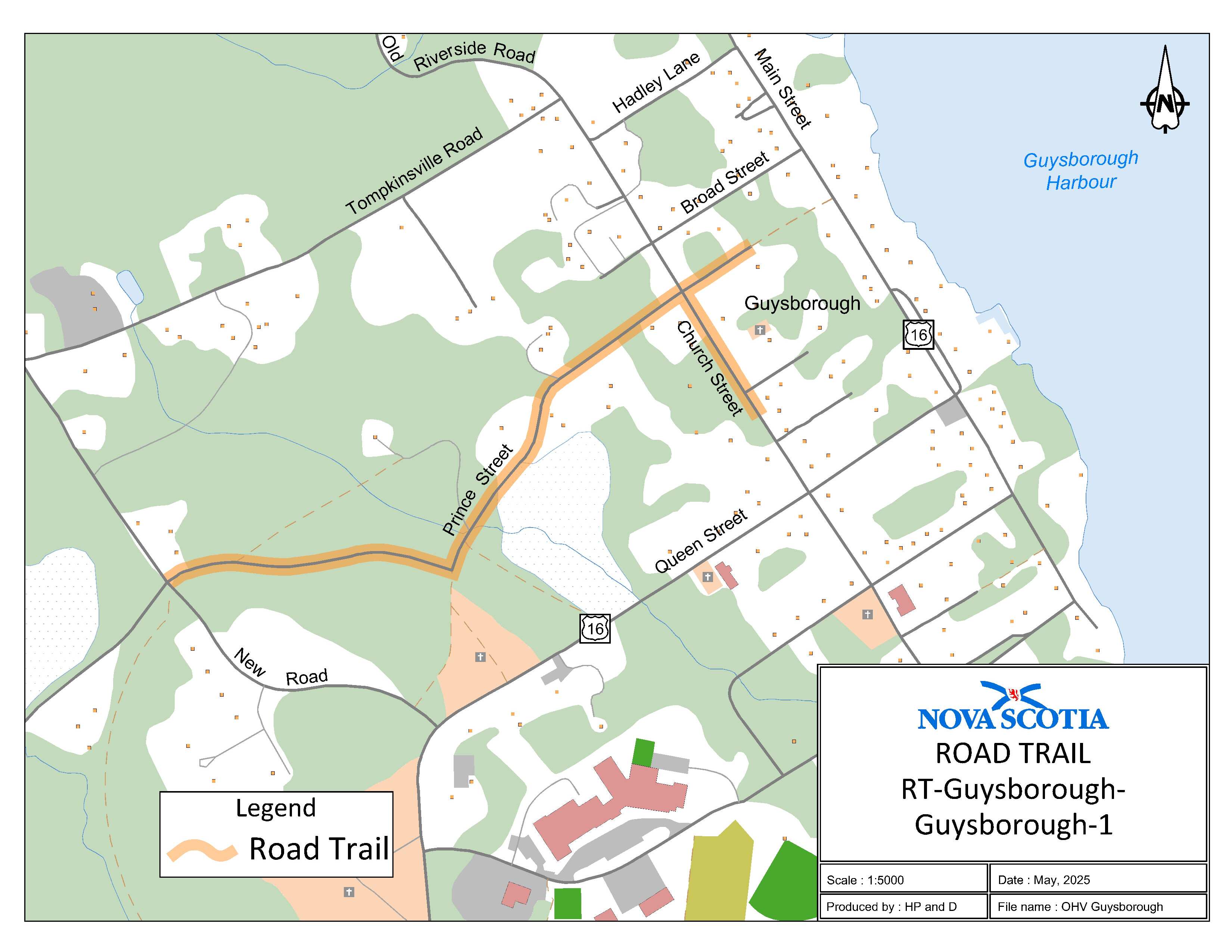
Appendix AK: Guysborough, Guysborough County
The road trail begins at the intersection of New Road, Sunnyville Road, Round Top Road and Prince Street at coordinates 45.389272°N, 61.509330°W and goes east on Prince Street for 0.85 km adjacent to civic 164 Prince Street at coordinates 45.392820°N, 61.500764°W. The road trail continues southeast from the intersection of Prince Street and Church Street on Church Street for 0.18 km.
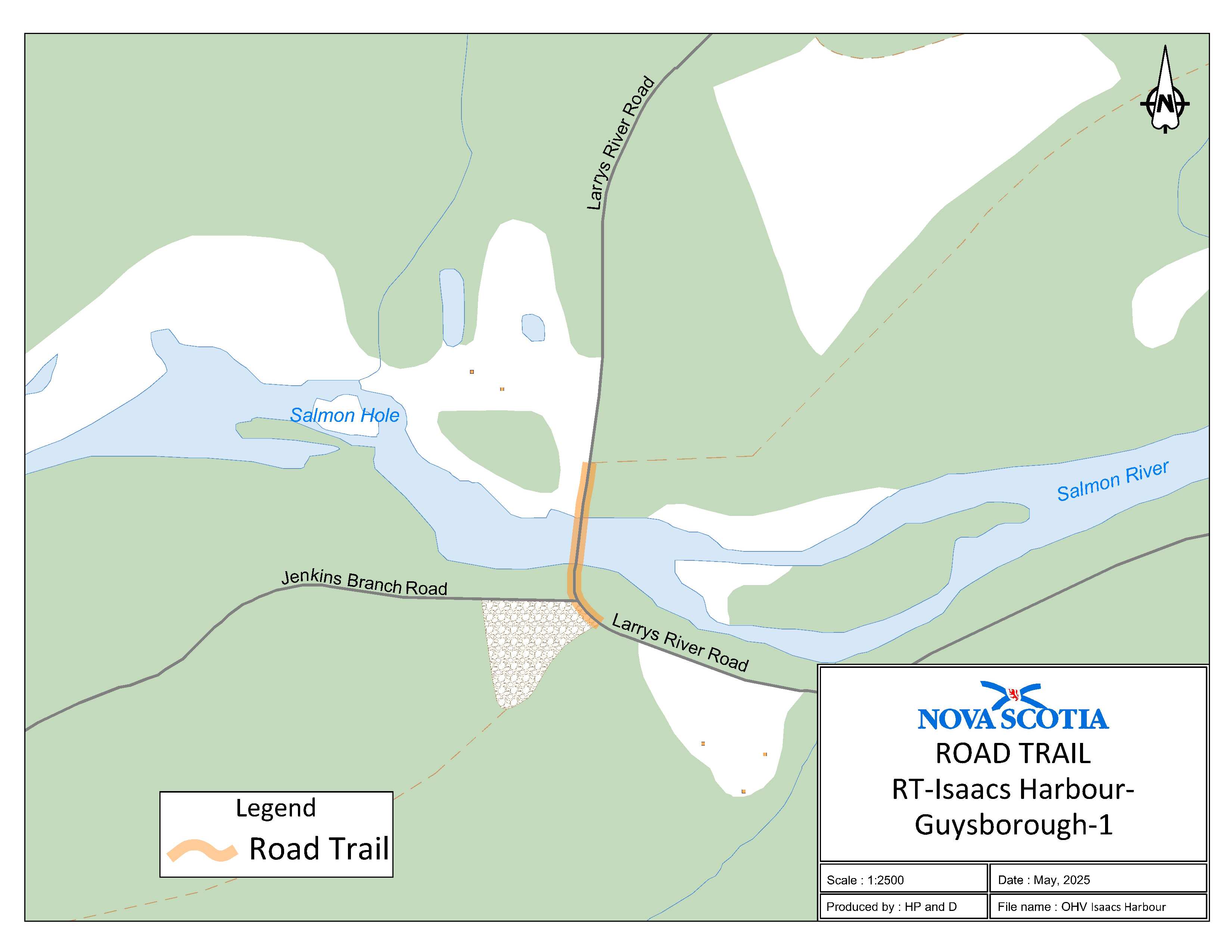
Appendix AL: Isaacs Harbour, Guysborough County
The road trail begins at the shared use trail 0.1 km west of civic 4465 Larrys River Road at coordinates 45.350773°N, 61.513956°W and goes north for 0.09 km. The road trail ends at the entrance of the shared use rail trail opposite civic 4509 Larrys River Road at coordinates 45.351582°N, 61.513908°W.
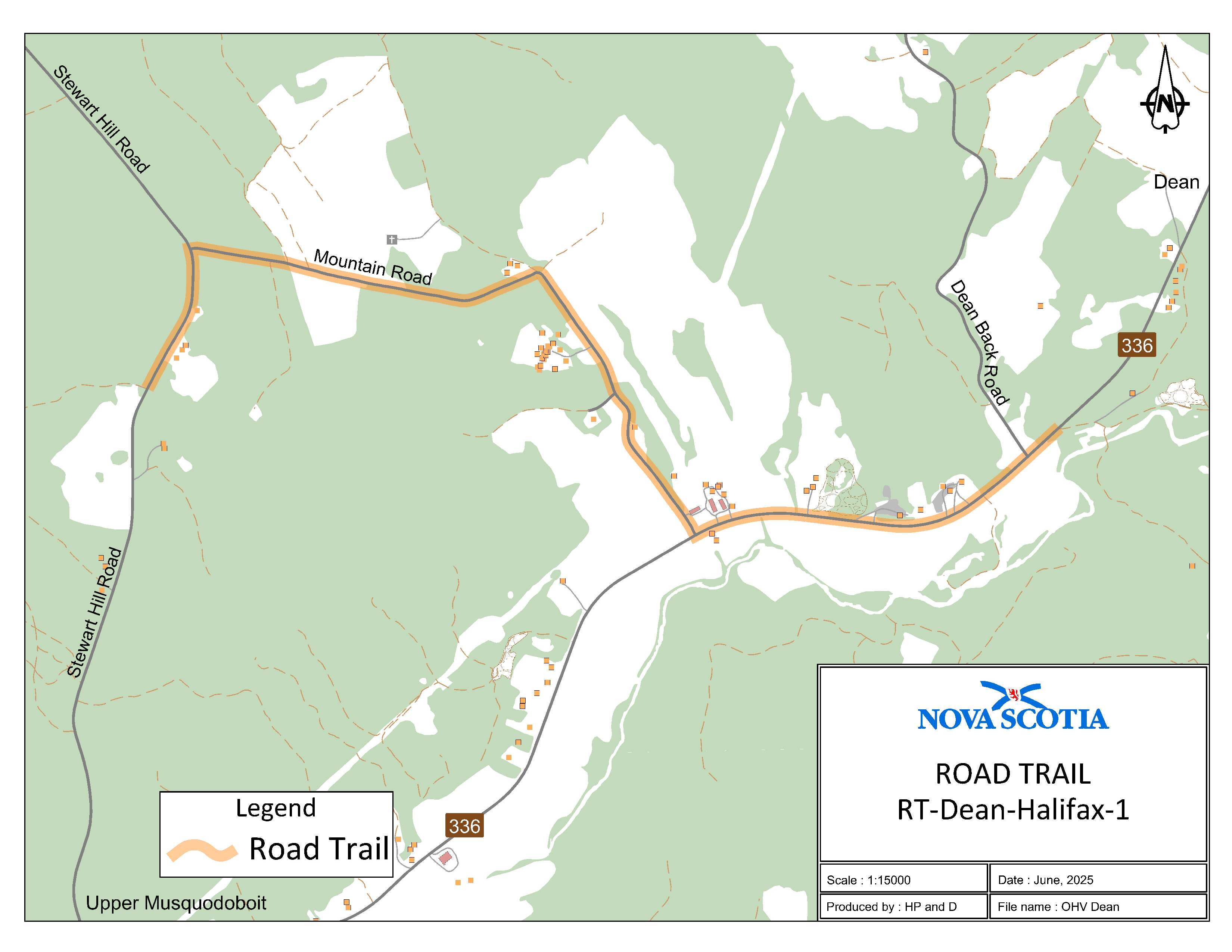
Appendix AM: Dean, Halifax Regional Municipality
The road trail begins at civic 311 Stewart Hill Road in Upper Musquodoboit at coordinates 45.161507°N, 62.945957°W and goes north for 1.22 km. The road trail then continues east on Mountain Road for 2.26 km. The road trail continues east on Route 336 and ends adjacent to civic 1008 Route 336 in Dean at coordinates 45.159690°N, 62.906631°W.
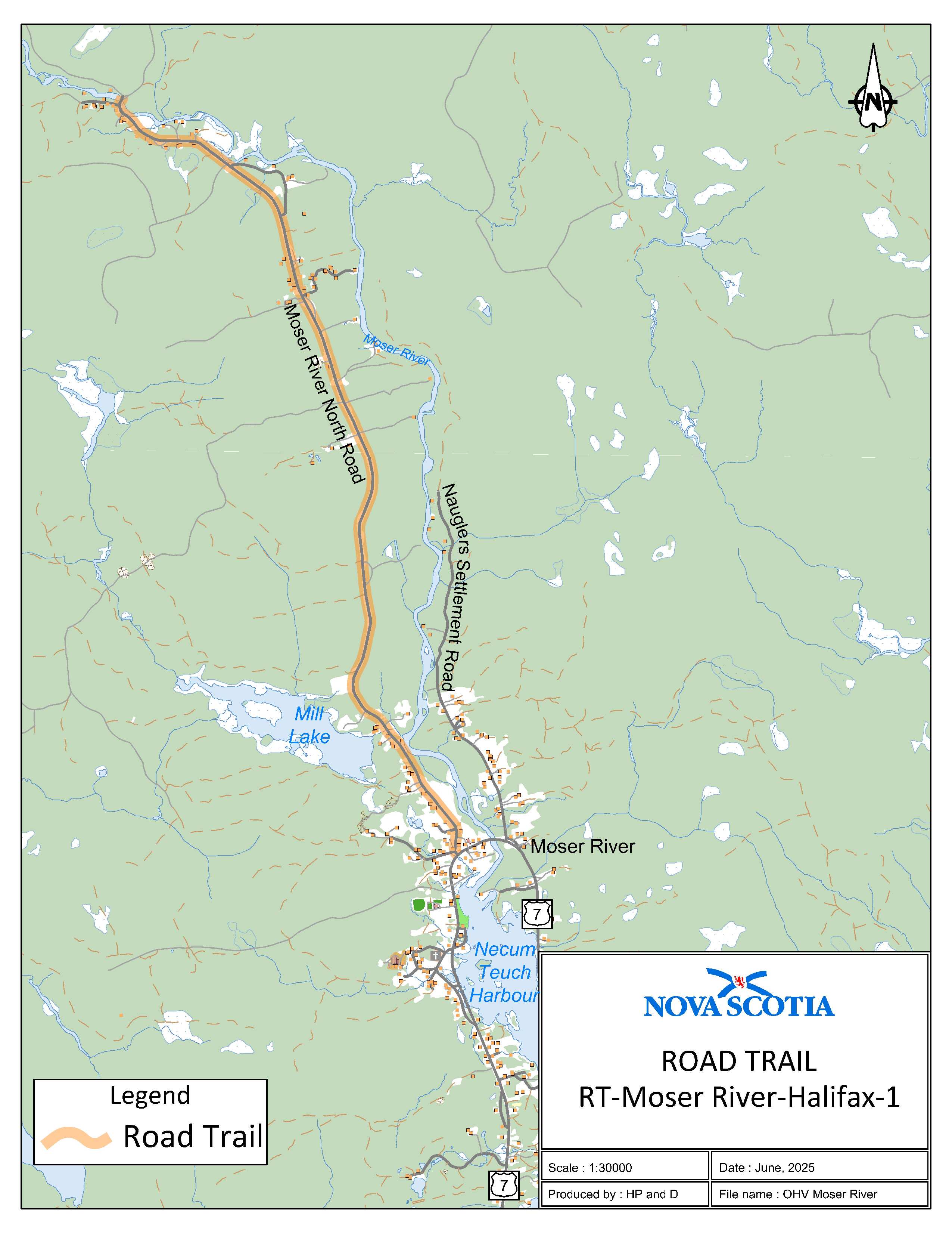
Appendix AN: Moser River, Halifax Regional Municipality
The road trail begins at the end of Moser River North Road immediately off Wilson Falls bridge at coordinates 45.021746°N, 62.285809°W heading southeast for 6.2 km.
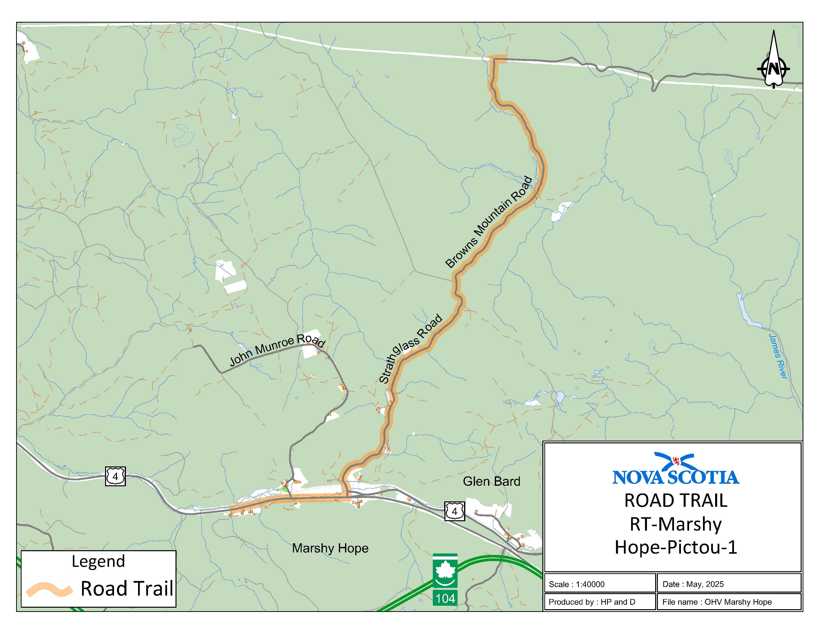
Appendix AO: Marshy Hope, Pictou County
The road trail begins at the intersection of the K-class section of Strathglass Road and the I-class section of Browns Mountain Road at coordinates 45.641805, 62.171600°W and goes south on Browns Mountain Road for 5.2 km. The road trail continues on Strathglass Road going south for 2.6 km. The road trail continues west on Trunk 4 for 1.6 km and ends at coordinates 45.585882°N, 62.219289°W.
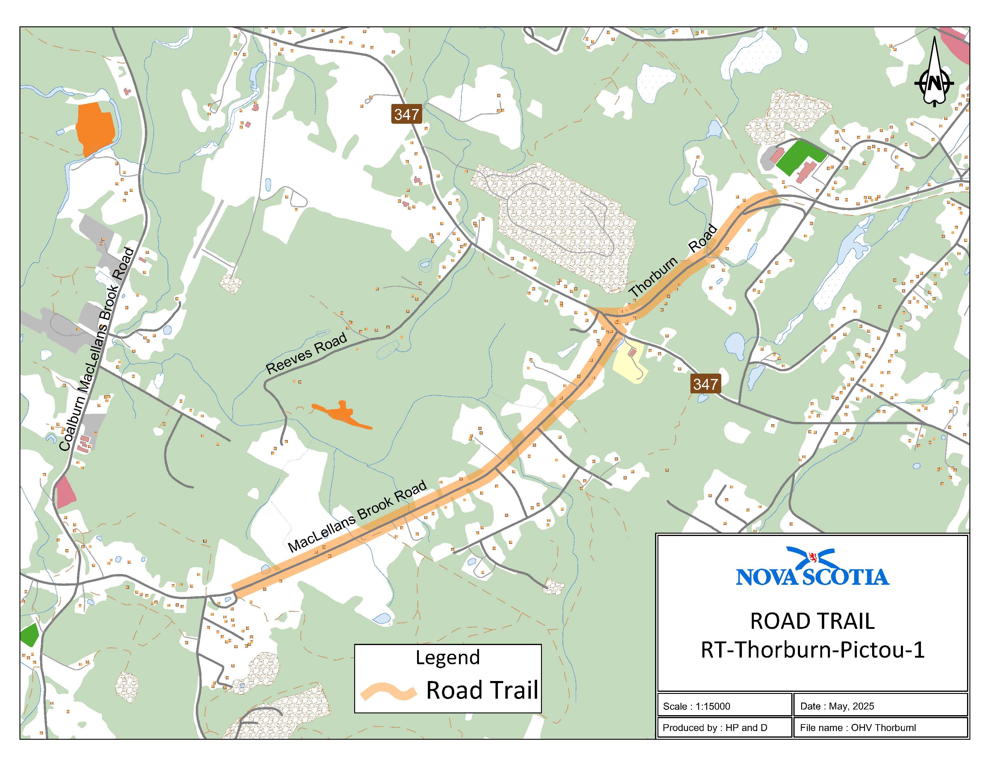
Appendix AP: Thorburn, Pictou County (Thorburn Road)
The road trail begins at coordinates 45.561159°N, 62.565423°W from where the OHV trail meets Thorburn Road and goes in a southwest direction to the intersection of Thorburn Road and Sherbrooke Road for 0.9 km. The second section of the road trail continues in a eastern direction on Route 347 from the intersection of Thorburn Road to Route 347 until it intersects with MacLellans Brook Road. The road trail continues in a western direction down MacLellans Brook Road for 1.9 km until it reaches Glen Road at coordinates 45.545823°N, 62.594539°W.
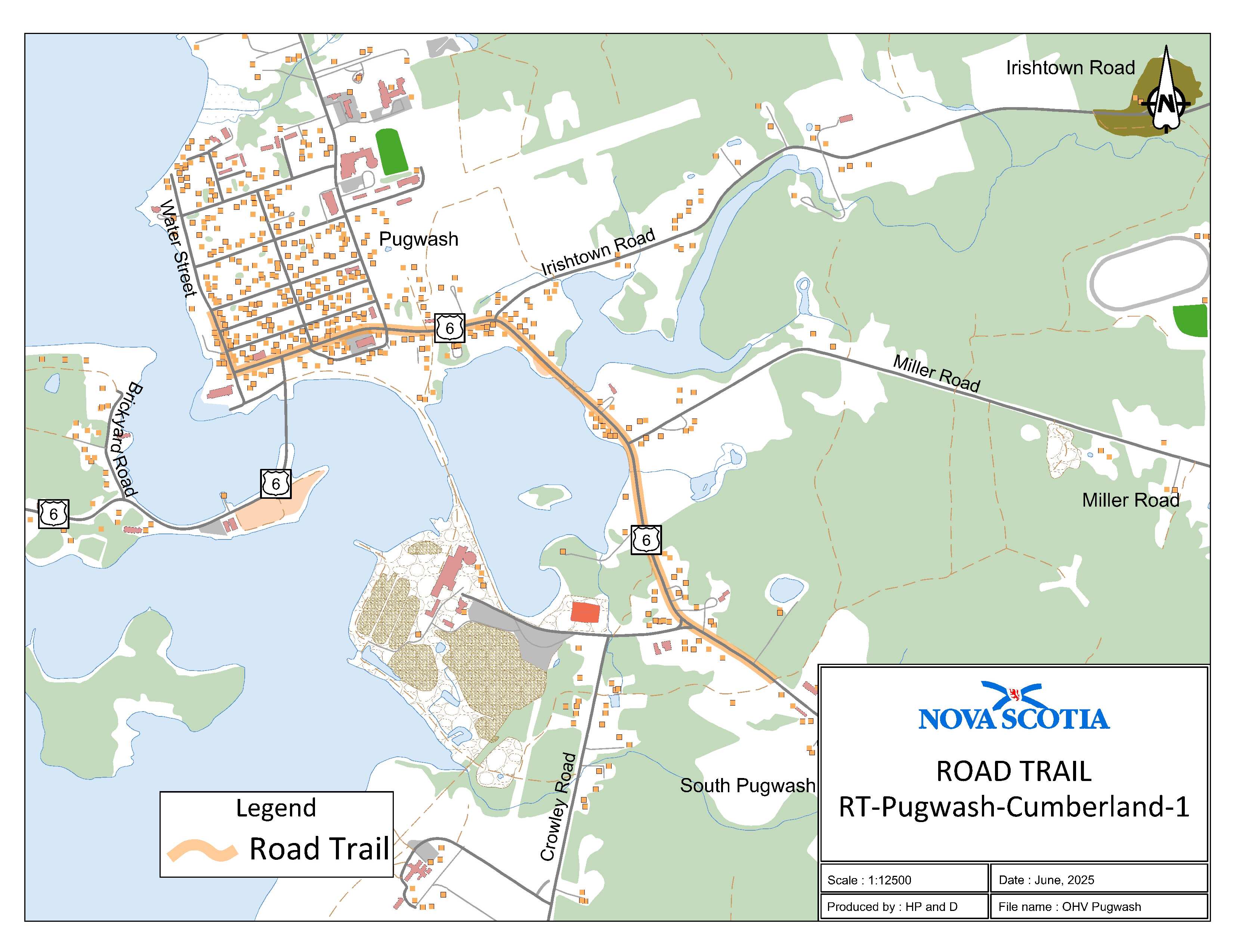
Appendix AQ: Pugwash, Cumberland County
The road trail begins adjacent to civic address 11054 on Trunk 6 at coordinates 45.841539°N, 63.643506°W and goes northwest on Trunk 6 for 2.13 km. The road trail continues on to Water Street for 0.59 km and ends at Cyrus Eaton Park.
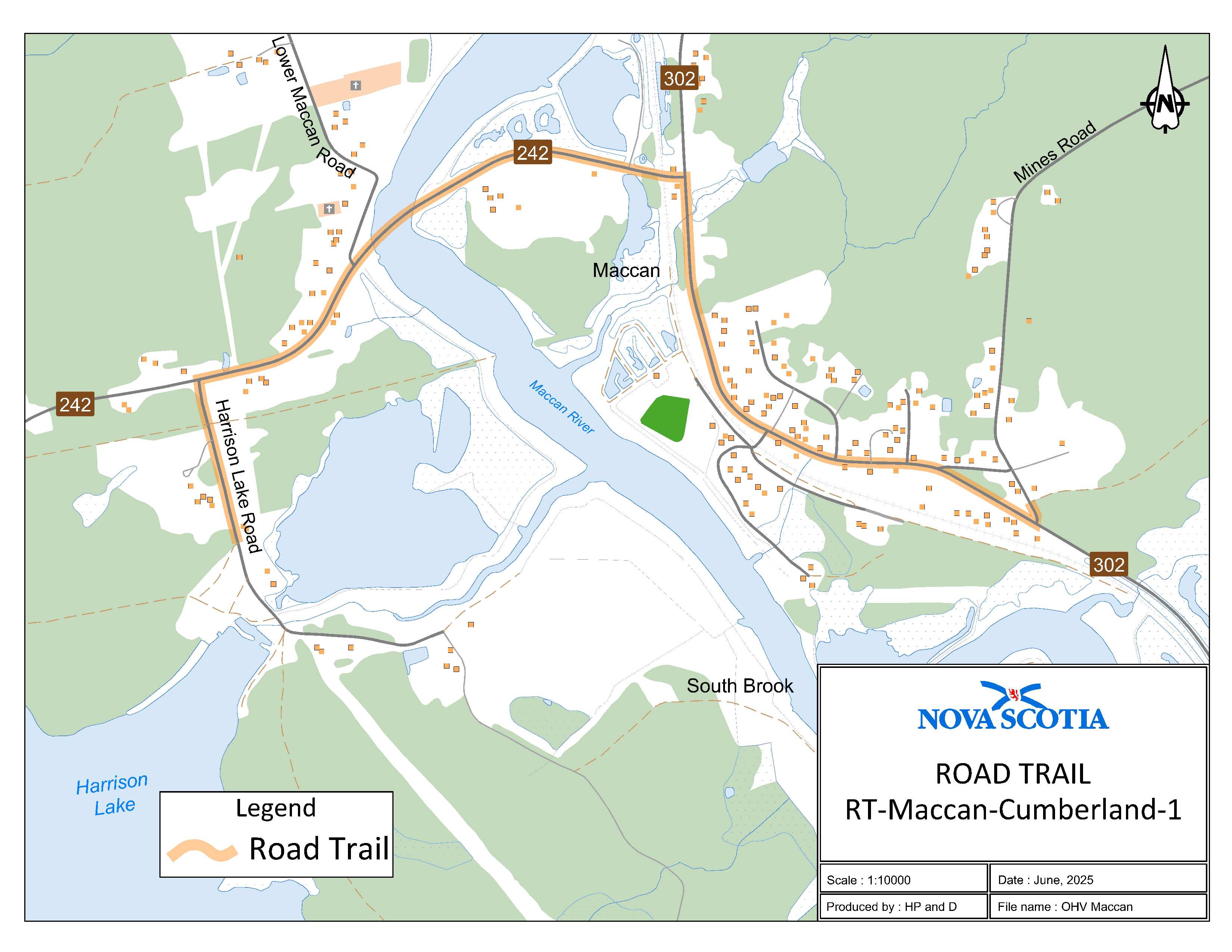
Appendix AR: Maccan, Cumberland County
The road trail begins adjacent to civic 10 Mines Road at coordinates 45.719140°N, 64.241861°W for 0.24 km. The road trail goes west on Route 302 for 1.06 km. The road trail then continues in a southwest direction on Route 242 for 1.31 km. The road trail then continues on Harrison Lake Road for 0.46 km and ends at coordinates 45.718242°N, 64.265047°W.
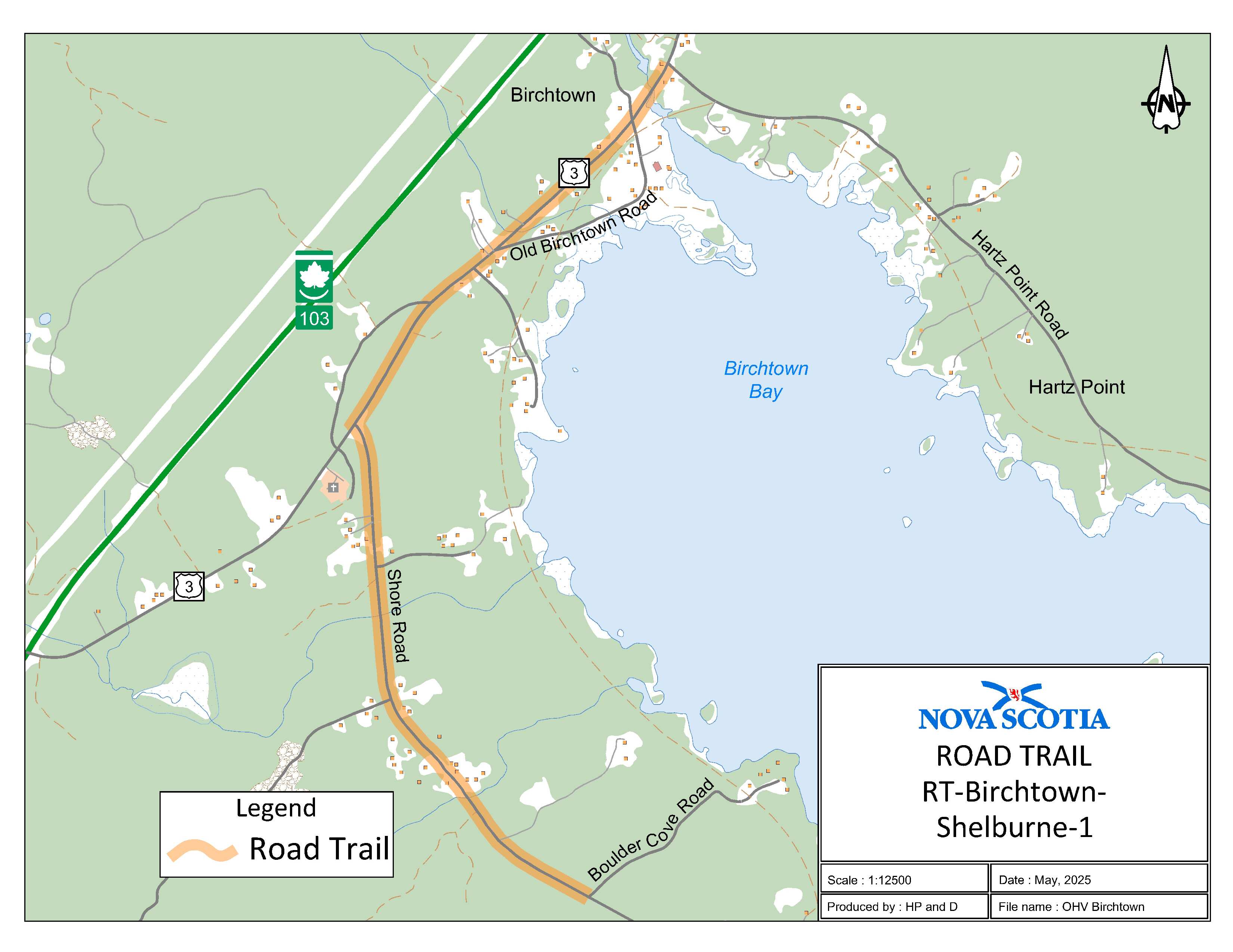
Appendix AS: Birchtown, Shelburne County
The road trail begins at where Hartz Point Road meets Trunk 3 at coordinates 43.749112°N, 65.377501°W. The road trail continues on Trunk 3 in [a] southwestern direction for 1.2 km. The road trail continues on to Shore Road in a southern direction for 1.62 km and ends at coordinates 43.727818°N, 65.379994°W.
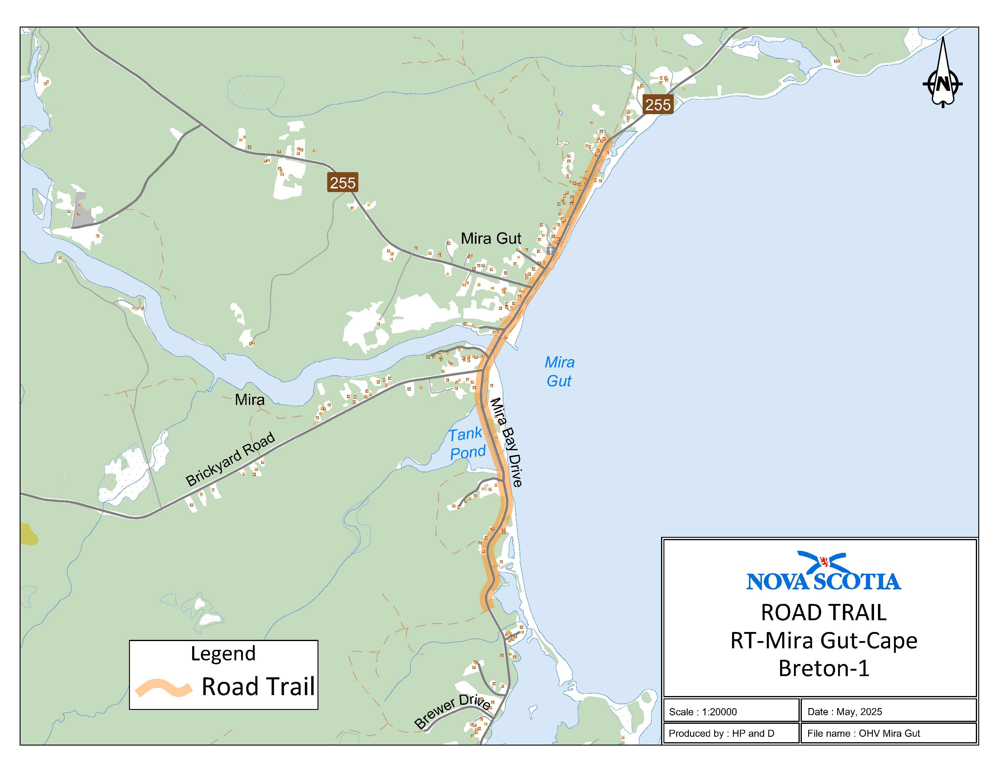
Appendix AT: Mira Gut, Cape Breton Regional Municipality
The road trail begins at the ATV trail 0.2 km north of Lakefront Drive on Mira Bay Drive at coordinates 46.022587°N, 59.969438°W and goes for 2 km. The road trail continues on Route 255 for 1 km and ends at civic 5486 on Route 255 at coordinates 46.046251°N, 59.959844°W.
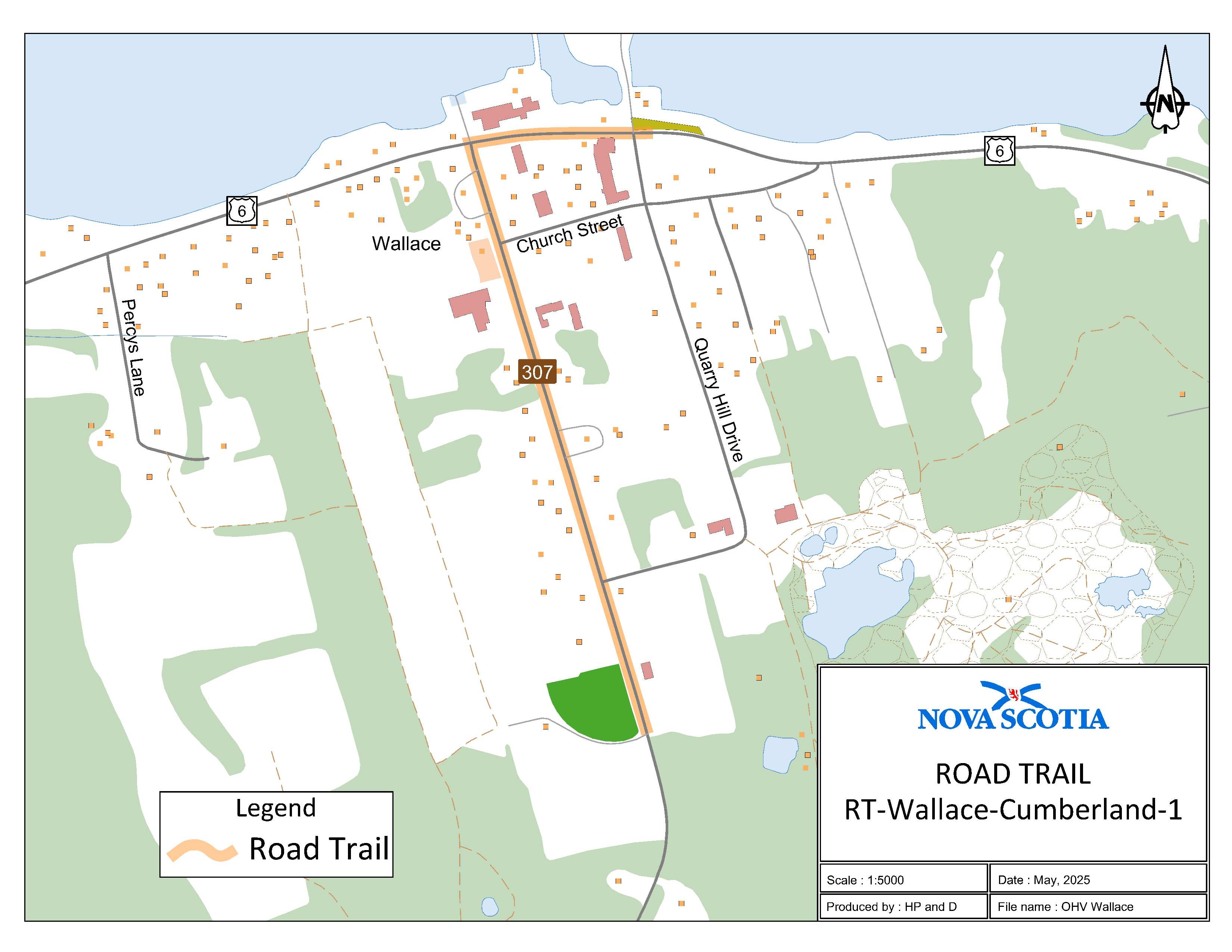
Appendix AU: Wallace, Cumberland County
The road trail begins adjacent to civic 3757 on Route 307 in Wallace at coordinates 45.807676°N, 63.471039°W and goes northwest for 0.7 km. The road trail then continues east on Trunk 6 for 0.2 km and ends at coordinates 45.814043°N, 63.470932°W.
Legislative History
Reference Tables
Road Trails Designation |
N.S. Reg. 2/2025 |
Road Trails Act |
|
Note: The information in these tables does not form part of the regulations and is compiled by the Office of the Registrar of Regulations for reference only. |
|
Source Law
The current consolidation of the Road Trails Designation made under the Road Trails Act includes all of the following regulations:
N.S. |
In force |
How in force |
Royal Gazette |
2/2025
|
Jan 7, 2025 |
date specified |
Jan 24, 2025 |
123/2025 |
Jun 25, 2025 |
date specified |
Jul 11, 2025 |
|
|
|
|
|
|
|
|
|
|
|
|
The following regulations are not yet in force and are not included in the current consolidation:
N.S. |
In force |
How in force |
Royal Gazette |
|
|
|
|
|
|
|
|
|
|
|
|
*See subsection 3(6) of the Regulations Act for
rules about in force dates of regulations.
ad. = added |
fc. = fee change |
rep. = repealed |
|
Provision affected
|
How affected
|
||
Appendices Z-AU............................ |
ad. 123/2025
|
||
|
|
||
|
|
||
|
|
||
|
|
||
Note that changes to headings are not included in the above table.
Editorial Notes and Corrections
|
Note |
Effective |
|
|
|
|
|
|
|
|
|
Repealed and Superseded
N.S. |
Title |
In force |
Repealed |
176/2023 |
Road Trails Designation |
Oct 2, 2023 |
Jan 7, 2025 |
Note: Only regulations that are specifically repealed and replaced appear in this table. It may not reflect the entire history of regulations on this subject matter.