| This consolidation is unofficial and is for reference only. For the official version of the regulations, consult the original documents on file with the Office of the Registrar of Regulations, or refer to the Royal Gazette Part II. |
| Regulations are amended frequently. Please check the list of Regulations by Act to see if there are any recent amendments to these regulations filed with our office that are not yet included in this consolidation. |
| Although every effort has been made to ensure the accuracy of this electronic version, the Office of the Registrar of Regulations assumes no responsibility for any discrepancies that may have resulted from reformatting. |
| This electronic version is copyright © , Province of Nova Scotia, all rights reserved. It is for your personal use and may not be copied for the purposes of resale in this or any other form. |
Quinns Meadow Nature Reserve Ecological Site Designation
made under Section 14 of the
Special Places Protection Act
R.S.N.S. 1989, c. 438
O.I.C. 2004-470 (effective December 3, 2004), N.S. Reg. 237/2004
including up to O.I.C. 2026-180 (effective June 12, 2026), N.S. Reg. 139/2026
Table of Contents
Please note: this table of contents is provided for convenience of reference and does not form part of the regulations.
Click here to go to the text of the regulations.
Order approved by O.I.C. 2004-470
Appendix “A” Quinns Meadow Nature Reserve
Appendix “C” Summary of Quinns Meadow Nature Reserve Management Plan
Order approved by O.I.C. 2015-181
Appendix A Addition to Quinns Meadow Nature Reserve Ecological Site
Appendix B Map of Addition to Quinns Meadow Nature Reserve
Order approved by O.I.C. 2026-180
Appendix A Description of Addition to Quinns Meadow Nature Reserve
Appendix B Map Showing Approximate Boundaries of Addition to Quinns Meadow
Nature Reserve
Order approved by O.I.C. 2004-470
I hereby designate as an ecological site pursuant to subsections (1), (2), (3), and (4) of Section 14 of Chapter 438 of the Revised Statutes of Nova Scotia, 1989, the Special Places Protection Act, the land described in Appendix “A” and shown on the map attached as Appendix “B”, which ecological site shall be managed in accordance with the Quinns Meadow Nature Reserve Management Plan dated September 24, 2004, and filed at the office of the Department of Environment and Labour at Halifax, a summary of which is attached as Appendix “C”, all appendices being attached to and forming part of the designation, which shall be known as the Quinns Meadow Nature Reserve, effective on the date of publication of the designation in the Royal Gazette.
Sgd: K. Morash
Kerry Morash
Minister of Environment and Labour
Dated and signed at Halifax, Nova Scotia
October 26, 2004.
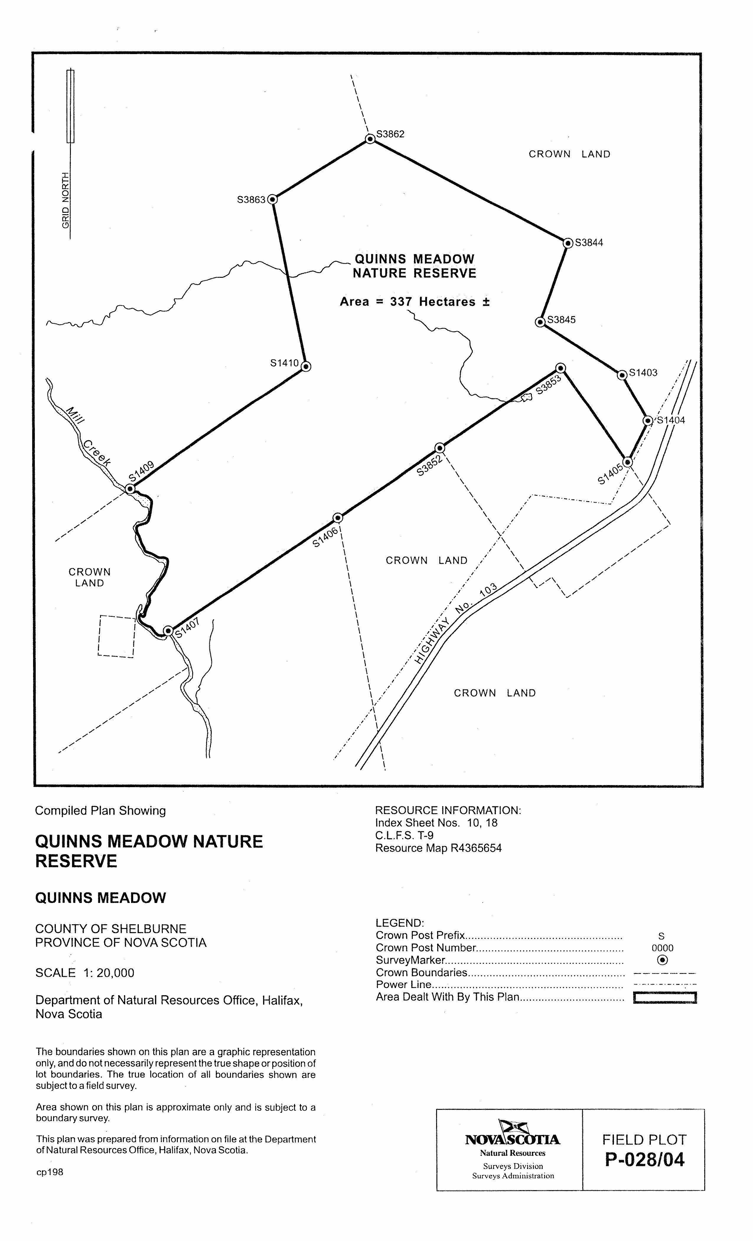
Appendix “A”
Quinns Meadow Nature Reserve
ALL that certain tract of land and land covered by water shown outlined in bold line on Compiled Plan Showing Quinns Meadow Nature Reserve, filed at Department of Natural Resources Office at Halifax, under Field Plot P-028/04, said tract of land located at Quinns Meadow, Shelburne County, Province of Nova Scotia.
CONTAINING an approximate area of 337 hectares.
Appendix “C”
Summary of Quinns Meadow Nature Reserve Management Plan
The management plan for Quinns Meadow Nature Reserve describes the outstanding natural features, boundaries, and management prescription for this reserve, located approximately 16 km southwest of Shelburne, Shelburne County, Nova Scotia. The management plan gives guidance to those charged with maintaining the ecological integrity of the reserve, emphasizing the most fundamental principle of nature reserve management—that protection must take priority over use.
Quinns Meadow is a large (376-hectare), Sphagnum-sedge-dominated bog/fen located along the lower Clyde River. It is one of four bogs in Canada known to contain a nationally endangered coastal plain plant species, Thread-leaved Sundew (Drosera filiformis). Quinn’s Meadow also contains a population of Long’s Bulrush (Scirpus longii), a species of national special concern.
Quinns Meadow Nature Reserve encompasses approximately 337 hectares, consisting of that portion of an upstream bog which feeds Quinns Meadow, as well as slopes adjacent to both Quinns Meadow and the feeder bog. The reserve also includes a narrow southeastward extension towards Bowers Meadows Wilderness Area. Significant portions of Quinns Meadow are located on private lands. These areas amount to over 300 hectares, the largest being a 200-hectare portion of the southern end of the bog. These areas are not included in the designated nature reserve but are critical areas for private land stewardship or acquisition. A significant portion of Quinns Meadow and adjacent slope, amounting to over 100 hectares is claimed by both the Province and private parties. These lands may eventually be added to the nature reserve, should a resolution be found.
As provided for in the Special Places Protection Act, Quinns Meadow Nature Reserve is to be managed to a high standard of protection, equivalent to IUCN Class Ia (Strict Nature Reserve), in keeping with the overriding goal of maintenance and restoration of ecological integrity.
Private land stewardship and securement are critical to the protection of Quinns Meadow and the rare and endangered species it contains. Access to the reserve for environmental education and nature appreciation purposes will be permitted to the extent that protection goals are not compromised. Motorized and non-motorized vehicle access (including ATVs, motorcycles, and mountain bikes) will not be permitted. With the exception of forest fires, natural processes will be allowed to take place in the absence of any direct human interference.
Staff will carry out regular (at least annual or more frequently if specifically warranted) and opportunistic inspections to assess compliance with the Act and the management plan.
Order approved by O.I.C. 2015-181
I, Randy Delorey, Minister of Environment for the Province of Nova Scotia, pursuant to Section 14 of Chapter 438 of the Revised Statutes of Nova Scotia, 1989, the Special Places Protection Act, hereby designate the area of land described in Appendix A and shown on the map attached as Appendix B as an addition to the Quinns Meadow Nature Reserve Designation, N.S. Reg. 237/2004, made by the Minister of Environment and Labour and approved by the Governor in Council by Order in Council 2004-470 dated December 3, 2004.
Pursuant to subsection 14(3) of the Act, this designation is effective on and after the date it is published in the Royal Gazette.
In accordance with subsection 14(6) of the Act, this description will be registered in the registry of deeds office for the registration district in which the lands are situated.
Dated and made at Halifax Regional Municipality, Province of Nova Scotia, March 24, 2015.
sgd: Randy Delorey
Honourable Randy Delorey
Minister of Environment
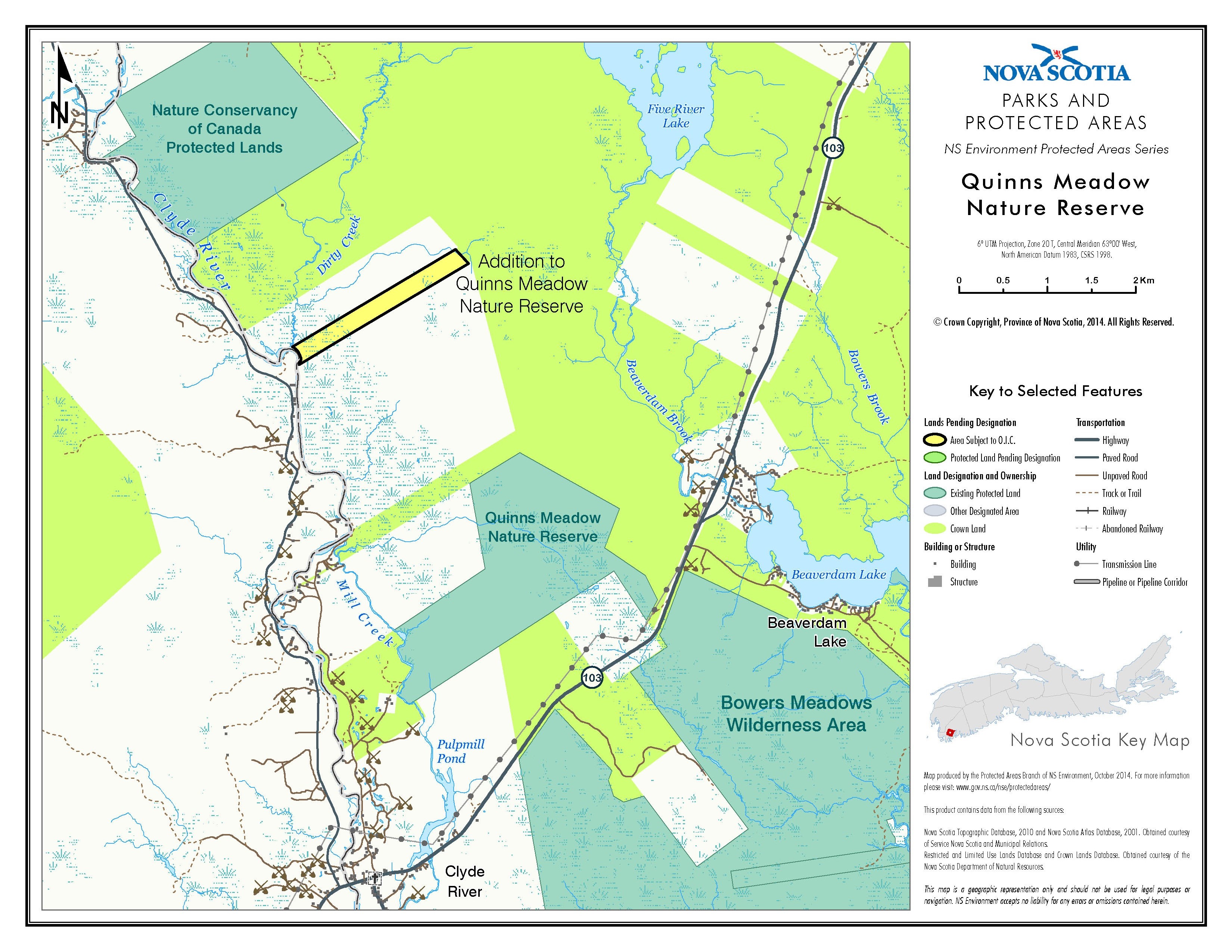
Appendix A
Addition to Quinns Meadow Nature Reserve Ecological Site
(original designation approved by Order in Council 2004-470)
ALL that certain parcel 24-13 of land and land covered by water located near Clyde River, in the County of Shelburne, Province of Nova Scotia, shown outlined in bold line on Field Plot P-024/13, filed at the Surveys Division at the Department of Natural Resources, Halifax, Nova Scotia and containing a total area of 46.1 hectares more or less.
Appendix B
Map of Addition to Quinns Meadow Nature Reserve
Order approved by O.I.C. 2026-180
I, Timothy Halman, Minister of Environment and Climate Change for the Province of Nova Scotia, pursuant to Section 14 of Chapter 438 of the Revised Statutes of Nova Scotia, 1989, the Special Places Protection Act, hereby designate the area of land described in Appendix A and shown on the map attached as Appendix B, as an addition to the Quinns Meadow Nature Reserve ecological site designation, N.S. Reg. 237/2004, made by the Minister of Environment and Labour and approved by the Governor in Council by Order in Council 2004-470 dated December 3, 2004.
Pursuant to subsection 14(3) of the Act, this designation is effective on and after the date it is published in the Royal Gazette.
In accordance with subsection 14(6) of the Act, this description will be registered in the registry of deeds office for the registration district in which the lands are situated.
Dated and made at Halifax Regional Municipality, Province of Nova Scotia, March 12, 2026.
sgd. T. Halman
Honourable Timothy Halman
Minister of Environment and Climate Change
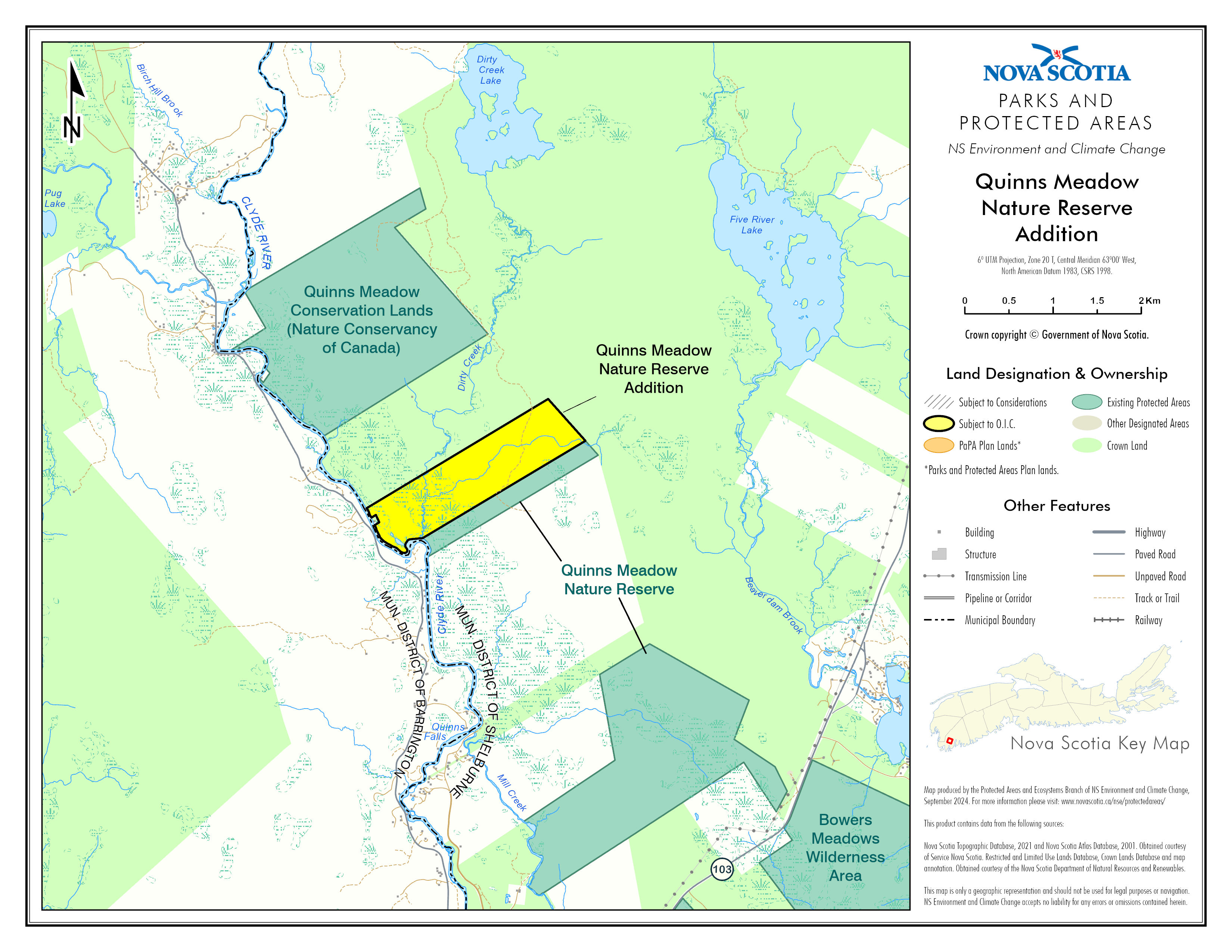
Appendix A
Description of Addition to Quinns Meadow Nature Reserve
All that certain piece or parcel of land situate, lying and being near Upper Clyde Road in Clyde River, in the County of Shelburne and Province of Nova Scotia, and shown as Lot QMNR on a Compiled Plan prepared by Matthew J. LeBlanc, NSLS, Plan Number 2025-366C, dated October 30, 2025, and bounded and described as follows:
Beginning at a survey marker at the southeastern corner of Lot 42, said survey marker being designated as point A on the abovementioned plan and being the Point of Beginning;
Thence south 42 degrees 45 minutes 57 seconds east, a distance of 652.755 metres, along the western boundary of Crown Land, to a survey marker (Crown No. S1532);
Thence south 58 degrees 05 minutes 51 seconds west, a distance of 746.226 metres, along the northern boundary of Lot 38, Crown Land, to a survey marker (Crown No. S1531);
Thence continuing south 58 degrees 05 minutes 51 seconds west, a distance of 663.041 metres, along the northern boundary of Lot 38, Crown Land, to a survey marker (Crown No. S1530);
Thence continuing south 58 degrees 05 minutes 51 seconds west, a distance of 739.005 metres, along the northern boundary of Lot 38, Crown Land, to a survey marker (Crown No. S1529);
Thence continuing south 58 degrees 05 minutes 51 seconds west, a distance of 6.0 metres more or less, along the northern boundary of Lot 38, Crown Land, to a point on the ordinary high water mark of Clyde River;
Thence in a generally northwesterly direction following the various courses of the eastern boundary of Clyde River to a calculated point at the southwestern corner of Lot 1, said calculated point being north 75 degrees 29 minutes 29 seconds west, a distance of 565.024 metres, from aforementioned survey marker (Crown No. S1529);
Thence north 56 degrees 48 minutes 08 seconds east, a distance of 61.316 metres more or less, along the southern boundary of Lot 1, to a survey marker;
Thence north 25 degrees 31 minutes 10 seconds west, a distance of 92.267 metres, along the eastern boundary of Lot 1, to a survey marker;
Thence south 56 degrees 48 minutes 08 seconds west, a distance of 61.240 metres more or less, along the northern boundary of Lot 1, to a calculated point on the ordinary high water mark of Clyde River;
Thence in a generally northwesterly direction following the various courses of the eastern boundary of Clyde River to the southwestern corner of Lot 42;
Thence north 58 degrees 00 minutes 39 seconds east, a distance of 3.8 metres more or less, along the southern boundary of Lot 42, to a survey marker, said survey marker being north 27 degrees 59 minutes 21 seconds west, a distance of 136.803 metres, from aforementioned calculated point;
Thence continuing north 58 degrees 00 minutes 39 seconds east, a distance of 2395.156 metres, along the southern boundary of Lot 42, to a survey marker, said survey marker being the Point of Beginning.
A tract of land containing an area of 156 hectares more or less.
All distances are horizontal grid distances, combined scale factor 0.9999764 applied.
All bearings are Grid, based on a 3 degree Modified Transverse Mercator Projection, Zone 5, Central Meridian 64 degrees 30 minutes west longitude, NAD 83 (CSRS) 2010.0 V7.
Appendix B
Map Showing Approximate Boundaries of Addition to
Quinns Meadow Nature Reserve
Legislative History
Reference Tables
Quinns Meadow Nature Reserve Designation |
N.S. Reg. 237/2004 |
Special Places Protection Act |
|
Note: The information in these tables does not form part of the regulations and is compiled by the Office of the Registrar of Regulations for reference only. |
|
Source Law
The current consolidation of the Quinns Meadow Nature Reserve Designation made under the Special Places Protection Act includes all of the following regulations:
N.S. |
In force |
How in force |
Royal Gazette |
237/2004
|
Dec 24, 2004 |
date specified by law1 |
Dec 24, 2004 |
239/2015 |
Jul 10, 2015 |
date specified by law1 |
Jul 10, 2015 |
139/2026 |
Jun 12, 2026 |
date specified by law1 |
Jun 12, 2026 |
|
|
|
|
|
|
|
|
The following regulations are not yet in force and are not included in the current consolidation:
N.S. |
In force |
How in force |
Royal Gazette |
|
|
|
|
|
|
|
|
|
|
|
|
*See subsection 3(6) of the Regulations Act for
rules about in force dates of regulations.
ad. = added |
fc. = fee change |
rep. = repealed |
|
Provision affected
|
How affected
|
||
Order approved by O.I.C. 2015-181 |
ad. 239/2015
|
||
Order approved by O.I.C. 2026-180 |
ad. 139/2026
|
||
Note that changes to headings are not included in the above table.
Editorial Notes and Corrections
|
Note |
Effective |
1 |
Pursuant to subsection 14(3) of the Act, the designation is effective on and after the date it is published in the Royal Gazette. |
|
2 |
References to the Department and Minister of Environment and Labour should be read as references to the Department and Minister of Environment in accordance with O.I.C. 2008-161 under the Public Service Act, R.S.N.S. 1989, c. 376. |
Apr 1, 2008 |
3 |
References to the Department of Natural Resources should be read as references to the Department of Lands and Forestry in accordance with O.I.C. 2018-188 under the Public Service Act, R.S.N.S. 1989, c. 376. |
Jul 18, 2018 |
4 |
References to the Department and Minister of Environment and Labour should be read as references to the Department and Minister of Environment and Climate Change in accordance with O.I.C. 2021-60 under the Public Service Act, R.S.N.S. 1989, c. 376. |
Feb 23, 2021 |
5 |
References to the Minister of Environment should be read as references to the Minister of Environment and Climate Change in accordance with O.I.C. 2021-60 under the Public Service Act, R.S.N.S. 1989, c. 376. |
Feb 23, 2021 |
6 |
References to the Department of Natural Resources should be read as references to the Department of Natural Resources and Renewables in accordance with O.I.C. 2021-210 under the Public Service Act, R.S.N.S. 1989, c. 376. |
Aug 31, 2021 |
7 |
References to the Department of Natural Resources should be read as references to the Department of Natural Resources in accordance with O.I.C. 2024-425 under the Public Service Act, R.S.N.S. 1989, c. 376. |
Dec 12, 2024 |
Repealed and Superseded
N.S. |
Title |
In force |
Repealed |
|
|
|
|
Note: Only regulations that are specifically repealed and replaced appear in this table. It may not reflect the entire history of regulations on this subject matter.