| This consolidation is unofficial and is for reference only. For the official version of the regulations, consult the original documents on file with the Office of the Registrar of Regulations, or refer to the Royal Gazette Part II. |
| Regulations are amended frequently. Please check the list of Regulations by Act to see if there are any recent amendments to these regulations filed with our office that are not yet included in this consolidation. |
| Although every effort has been made to ensure the accuracy of this electronic version, the Office of the Registrar of Regulations assumes no responsibility for any discrepancies that may have resulted from reformatting. |
| This electronic version is copyright © , Province of Nova Scotia, all rights reserved. It is for your personal use and may not be copied for the purposes of resale in this or any other form. |
Toy Makers Marsh Nature Reserve Ecological Site Designation
O.I.C. 2026-180 (effective June 12, 2026), N.S. Reg. 137/2026
Table of Contents
Please note: this table of contents is provided for convenience of reference and does not form part of the regulations.
Click here to go to the text of the regulations.
Order approved by O.I.C. 2026-180
Appendix A Description of Toy Makers Marsh Nature Reserve
Appendix B Map Showing Approximate Boundaries of Toy Makers Marsh Nature
Reserve
Order approved by O.I.C. 2026-180
I, Timothy Halman, Minister of Environment and Climate Change for the Province of Nova Scotia, pursuant to Section 14 of Chapter 438 of the Revised Statutes of Nova Scotia, 1989, the Special Places Protection Act, hereby designate the area of land described in Appendix A and shown on the map attached as Appendix B, as an ecological site to be known as Toy Makers Marsh Nature Reserve.
Pursuant to subsection 14(3) of the Act, this designation is effective on and after the date it is published in the Royal Gazette.
In accordance with subsection 14(6) of the Act, this description will be registered in the registry of deeds office for the registration district in which the lands are situated.
Dated and made at Halifax Regional Municipality, Province of Nova Scotia, March 12, 2026.
sgd. T. Halman
Honourable Timothy Halman
Minister of Environment and Climate Change
Appendix A
Description of Toy Makers Marsh Nature Reserve
All that certain piece or parcel of land situate, lying and being on Highway 101 in Marshalltown, in the County of Digby and Province of Nova Scotia, and shown as Lot TMMNR on a Compiled Plan prepared by Matthew J. LeBlanc, NSLS, Plan Number 2025-368C REV1, dated October 29, 2025, revised on January 16, 2026, and bounded and described as follows:
Beginning at a survey marker at the northeast corner of lands identified by PID 30148761, said survey marker being designated as point A on the abovementioned plan and being the POINT OF BEGINNING;
Thence south 63 degrees 12 minutes 33 seconds west, a distance of 40.234 metres, along the northern boundary of lands identified by PID 30148761, to a survey marker;
Thence south 33 degrees 27 minutes 30 seconds west, a distance of 21.502 metres, to a survey marker;
Thence south 53 degrees 52 minutes 59 seconds west, a distance of 35.352 metres, along the northern boundary of Lot 1-A, lands identified by PID 30148753, to a survey marker;
Thence north 79 degrees 11 minutes 43 seconds west, a distance of 43.829 metres, to a survey marker;
Thence south 48 degrees 23 minutes 55 seconds west, a distance of 80.467 metres, along the northern boundary of lands identified by PID 30148746, to a survey marker;
Thence south 41 degrees 36 minutes 05 seconds east, a distance of 72.542 metres, along the western boundary of lands identified by PID 30148746, to a survey marker;
Thence south 48 degrees 24 minutes 44 seconds west, a distance of 22.860 metres, along the northern boundary of lands identified by PID 30148738, to a survey marker;
Thence south 41 degrees 36 minutes 05 seconds east, a distance of 22.860 metres, along the western boundary of lands identified by PID 30148738, to a calculated point;
Thence in a southwesterly direction, following a curve to the right of radius 658.646 metres, an arc distance of 74.289 metres, along the northern boundary of Highway 101, to a survey marker, said survey marker being south 51 degrees 51 minutes 44 seconds west, a chord distance of 74.250 metres from the aforesaid calculated point;
Thence north 30 degrees 35 minutes 12 seconds west, a distance of 268.291 metres along the eastern boundary of Lot 3, lands identified by PID 30148704, to a survey marker;
Thence south 55 degrees 45 minutes 21 seconds west, a distance of 91.457 metres, along the northern boundary of Lot 3, lands identified by PID 30148704, to a survey marker;
Thence south 30 degrees 35 minutes 24 seconds east, a distance of 203.042 metres, along the western boundary of Lot 3, lands identified by PID 30148704, to a survey marker;
Thence south 55 degrees 58 minutes 03 seconds west, a distance of 66.977 metres, along the northern boundary of Lot 3A, lands identified by PID 30148696, to a survey marker;
Thence north 34 degrees 01 minutes 57 seconds west, a distance of 67.599 metres, along the eastern boundary of lands identified by PID 30148688, to a survey marker;
Thence south 56 degrees 01 minutes 00 seconds west, a distance of 80.775 metres, along the northern boundary of lands identified by PID 30148688, to a survey marker;
Thence north 34 degrees 37 minutes 23 seconds west, a distance of 181.408 metres, along the eastern boundary of lands identified by PID 30146724 and other lands identified by PID 30256200, to an axle;
Thence north 14 degrees 03 minutes 14 seconds east, a distance of 27.544 metres, along the eastern boundary of lands identified by PID 30256200, to an axle;
Thence north 28 degrees 54 minutes 35 seconds west, a distance of 128.141 metres, along the eastern boundary of lands identified by PID 30256200, to an axle;
Thence north 23 degrees 06 minutes 39 seconds east, a distance of 48.299 metres, along the southeast boundary of Lot 1000ABCDE, lands identified by PID 30321871, to a survey marker;
Thence north 27 degrees 57 minutes 33 seconds east, a distance of 52.352 metres, along the southeast boundary of Lot 1000ABCDE, lands identified by PID 30321871, to a survey marker;
Thence north 36 degrees 22 minutes 11 seconds east, a distance of 127.772 metres, along the southeast boundary of Lot 1000ABCDE, lands identified by PID 30321871, to a survey marker;
Thence north 19 degrees 51 minutes 31 seconds east, a distance of 96.196 metres, along the southeast boundary of Lot 1000ABCDE, lands identified by PID 30321871, to a survey marker;
Thence north 04 degrees 54 minutes 45 seconds east, a distance of 23.974 metres, along the southeast boundary of Lot 1000ABCDE, lands identified by PID 30321871, to a survey marker;
Thence north 09 degrees 57 minutes 28 seconds west, a distance of 32.014 metres, along the southeast boundary of Lot 1000ABCDE, lands identified by PID 30321871, to a survey marker;
Thence north 26 degrees 08 minutes 34 seconds west, a distance of 46.227 metres, along the southeast boundary of Lot 1000ABCDE, lands identified by PID 30321871, to a survey marker;
Thence north 48 degrees 20 minutes 31 seconds east, a distance of 77.444 metres, along the southeast boundary of Lot 1000ABCDE, lands identified by PID 30321871, to a survey marker;
Thence north 59 degrees 53 minutes 26 seconds east, a distance of 26.234 metres, along the southeast boundary of Lot 1000ABCDE, lands identified by PID 30321871, to a survey marker;
Thence north 73 degrees 49 minutes 15 seconds east, a distance of 49.958 metres, along the southeast boundary of Lot 1000ABCDE, lands identified by PID 30321871, to an axle;
Thence south 36 degrees 25 minutes 25 seconds east, a distance of 610.553 metres, along the western boundary of lands identified by PID 30148845, to a survey marker, said survey marker being the Point of Beginning.
A tract of land containing an area of 24.1440 hectares.
All distances are horizontal grid distances, combined scale factor 1.00003629 applied.
All bearings are Grid, based on a 3 degree Modified Transverse Mercator Projection, Zone 5, Central Meridian 64 degrees 30 minutes west Longitude, NAD 83 (CSRS) 2010.0 V7.
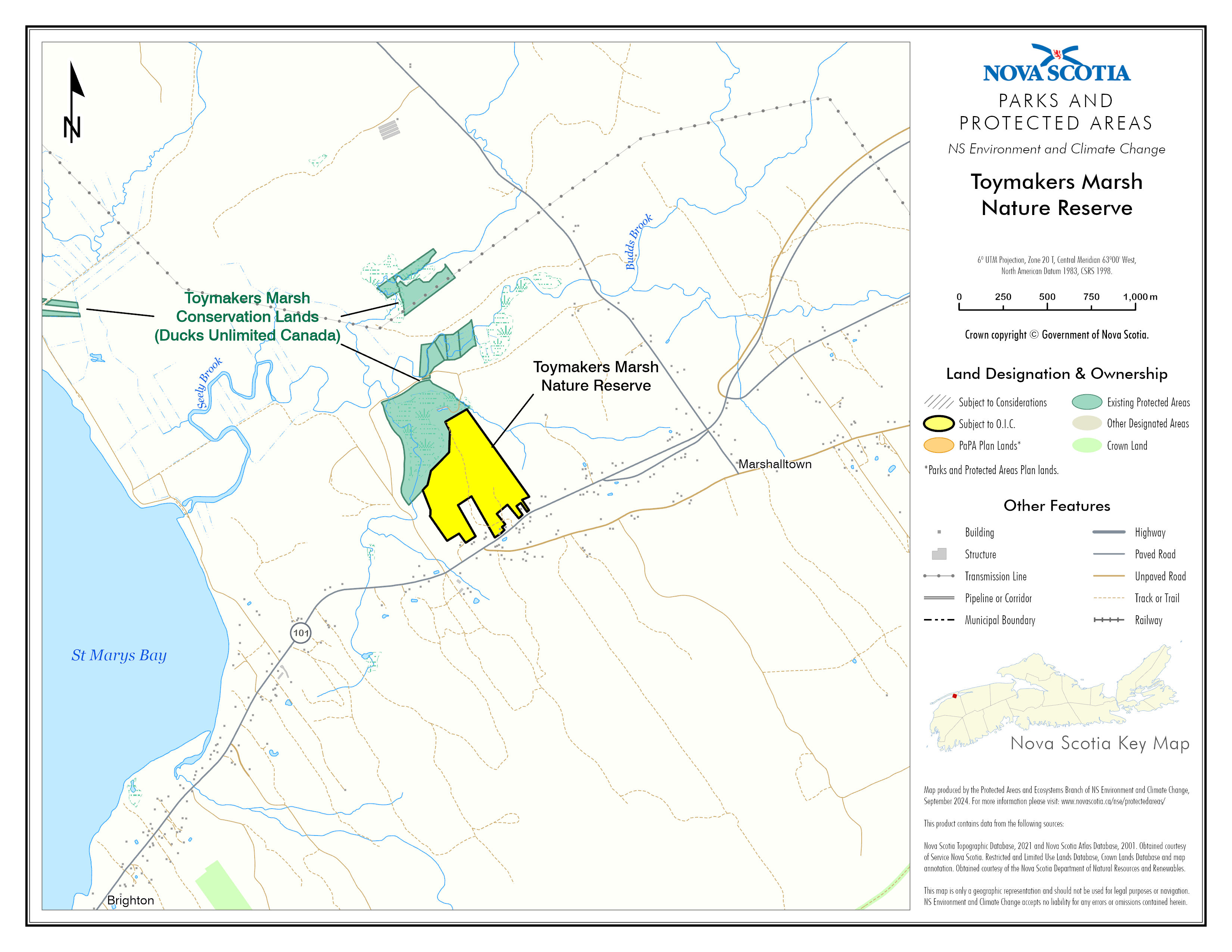
Appendix B
Map Showing Approximate Boundaries of
Toy Makers Marsh Nature Reserve
Legislative History
Reference Tables
Toy Makers Marsh Nature Reserve Ecological Site Designation |
N.S. Reg. 137/2026 |
Special Places Protection Act |
|
Note: The information in these tables does not form part of the regulations and is compiled by the Office of the Registrar of Regulations for reference only. |
|
Source Law
The current consolidation of the Toy Makers Marsh Nature Reserve Ecological Site Designation made under the Special Places Protection Act includes all of the following regulations:
N.S. |
In force |
How in force |
Royal Gazette |
137/2026
|
Jun 12, 2026 |
date specified by law1 |
Jun 12, 2026 |
|
|
|
|
|
|
|
|
|
|
|
|
|
|
|
|
The following regulations are not yet in force and are not included in the current consolidation:
N.S. |
In force |
How in force |
Royal Gazette |
|
|
|
|
|
|
|
|
|
|
|
|
*See subsection 3(6) of the Regulations Act for
rules about in force dates of regulations.
ad. = added |
fc. = fee change |
rep. = repealed |
|
Provision affected
|
How affected
|
||
.......................................................... |
|
||
|
|
||
|
|
||
|
|
||
|
|
||
Note that changes to headings are not included in the above table unless specifically referenced.
Editorial Notes and Corrections
|
Note |
Effective |
1 |
Pursuant to subsection 14(3) of the Act, the designation is effective on and after the date it is published in the Royal Gazette. |
|
|
|
|
|
|
|
Repealed and Superseded
N.S. |
Title |
In force |
Repealed |
|
|
|
|
Note: Only regulations that are specifically repealed and replaced appear in this table. It may not reflect the entire history of regulations on this subject matter.