| This consolidation is unofficial and is for reference only. For the official version of the regulations, consult the original documents on file with the Office of the Registrar of Regulations, or refer to the Royal Gazette Part II. |
| Regulations are amended frequently. Please check the list of Regulations by Act to see if there are any recent amendments to these regulations filed with our office that are not yet included in this consolidation. |
| Although every effort has been made to ensure the accuracy of this electronic version, the Office of the Registrar of Regulations assumes no responsibility for any discrepancies that may have resulted from reformatting. |
| This electronic version is copyright © , Province of Nova Scotia, all rights reserved. It is for your personal use and may not be copied for the purposes of resale in this or any other form. |
Road Trails Designation: Appendices A - Y
Table of Contents
Please note: this table of contents is provided for convenience of reference and does not form part of the regulations.
Click here to return to the index of all road trails designations.
Appendix A: Trunk 7 Sherbrooke Village Inn
Appendix H: Mountain Road, St. Peters
Appendix I: Capelin Cove, Richmond County
Appendix J: Doucetteville, Digby County
Appendix K: Framboise, Richmond County
Appendix L: Hospital Road (Sherbrooke, Guysborough County)
Appendix M: Mooseland, Halifax Regional Municipality
Appendix N: Riversdale, Colchester County
Appendix O: Kemptown, Colchester County
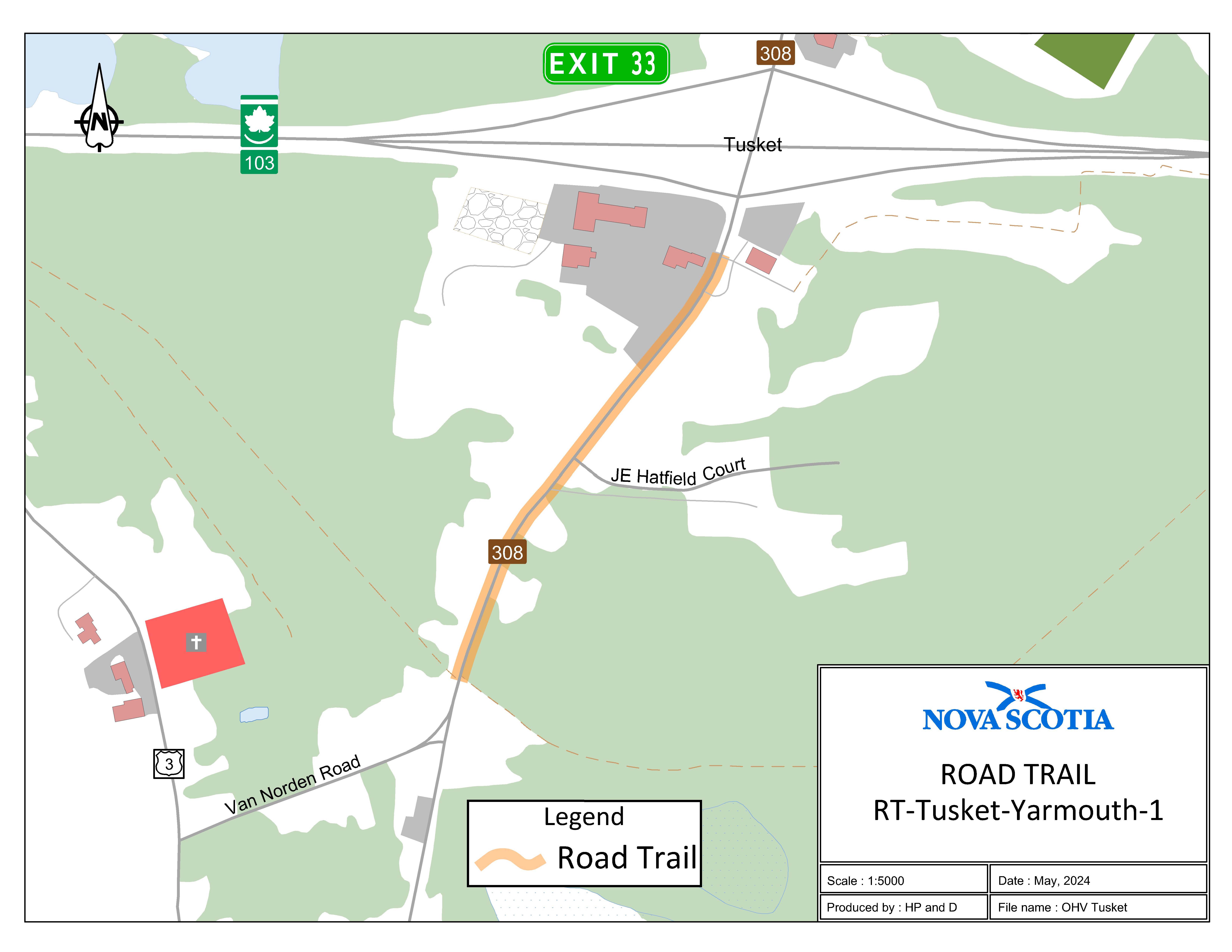
Appendix P: Route 308 (Tusket, Yarmouth County)
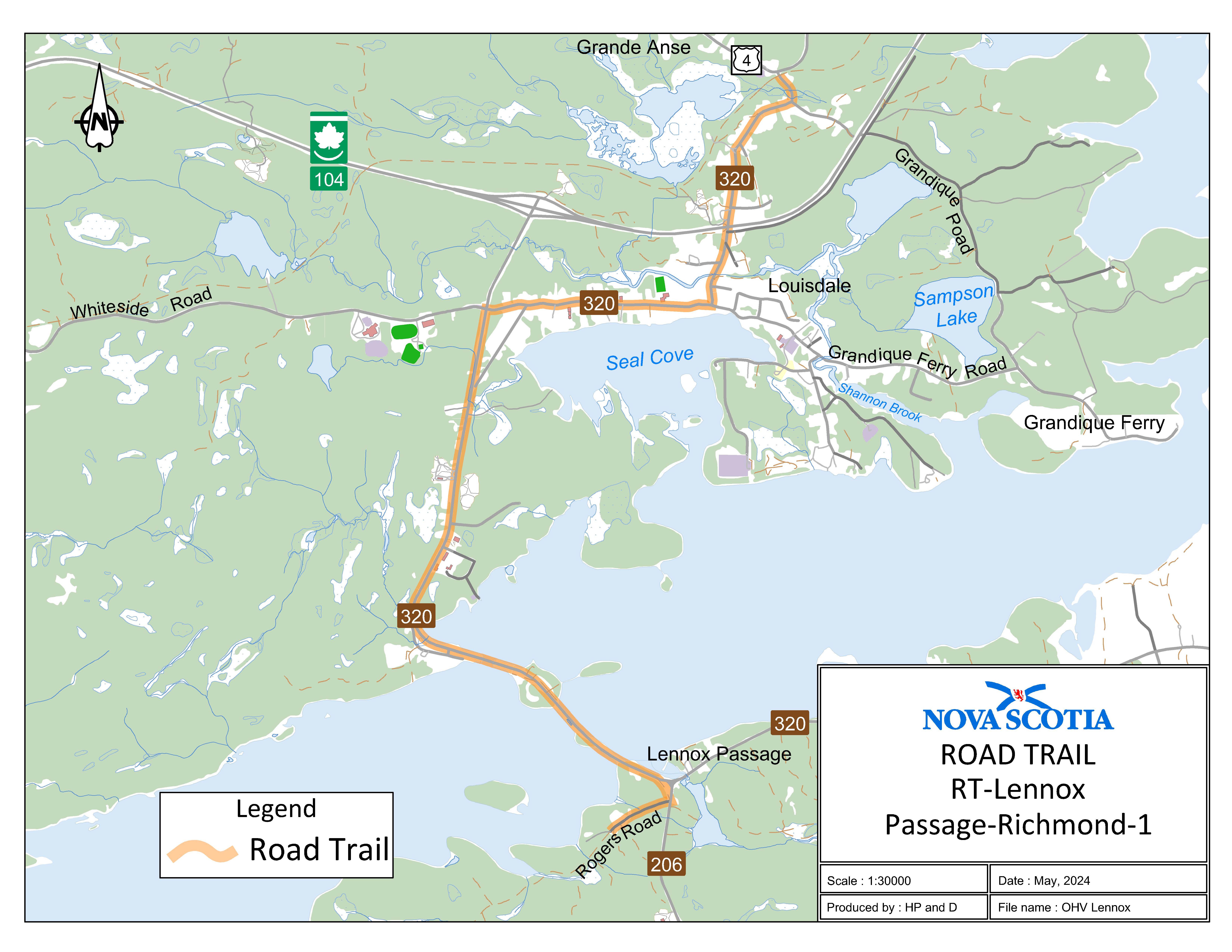
Appendix Q: Lennox Passage, Richmond County
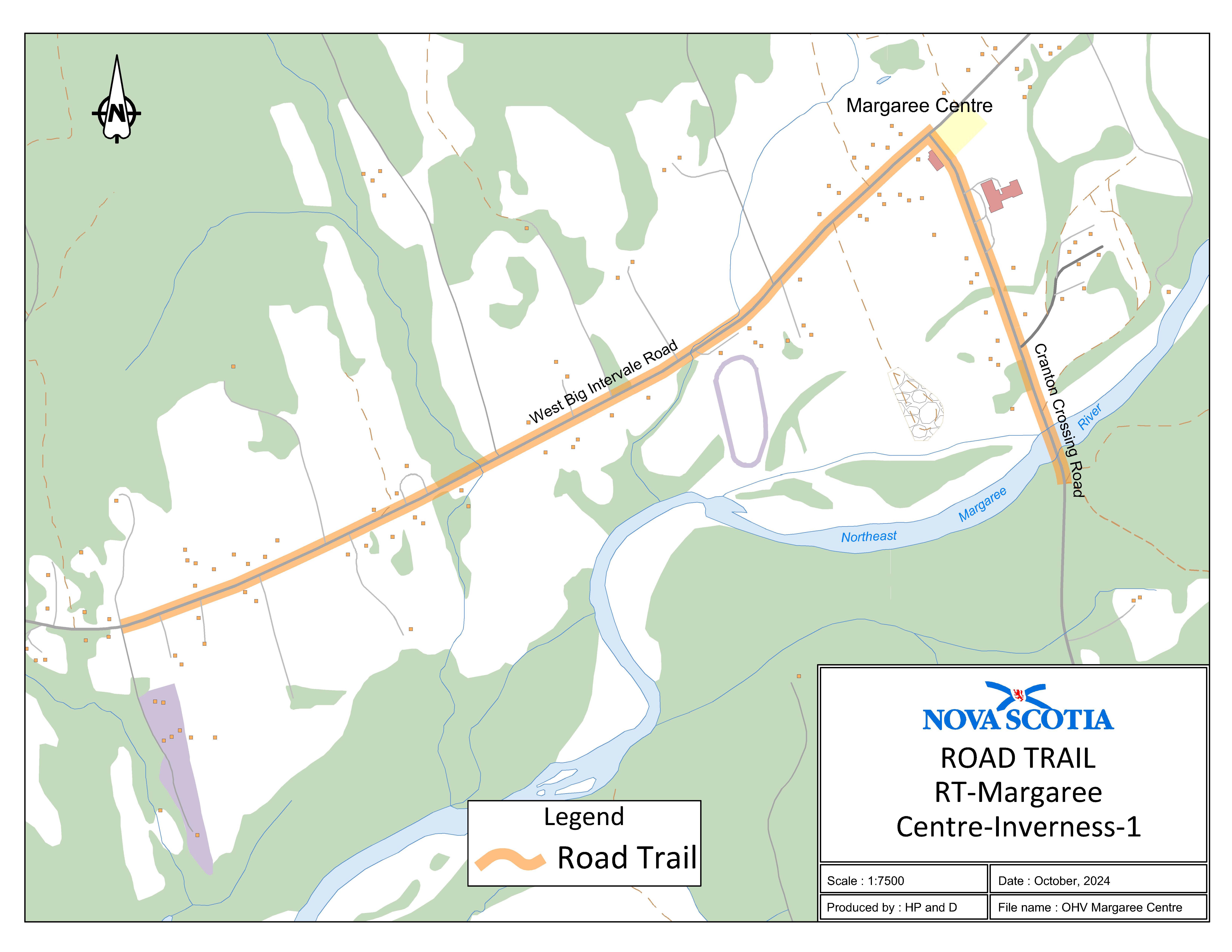
Appendix R: Margaree Centre, Inverness County
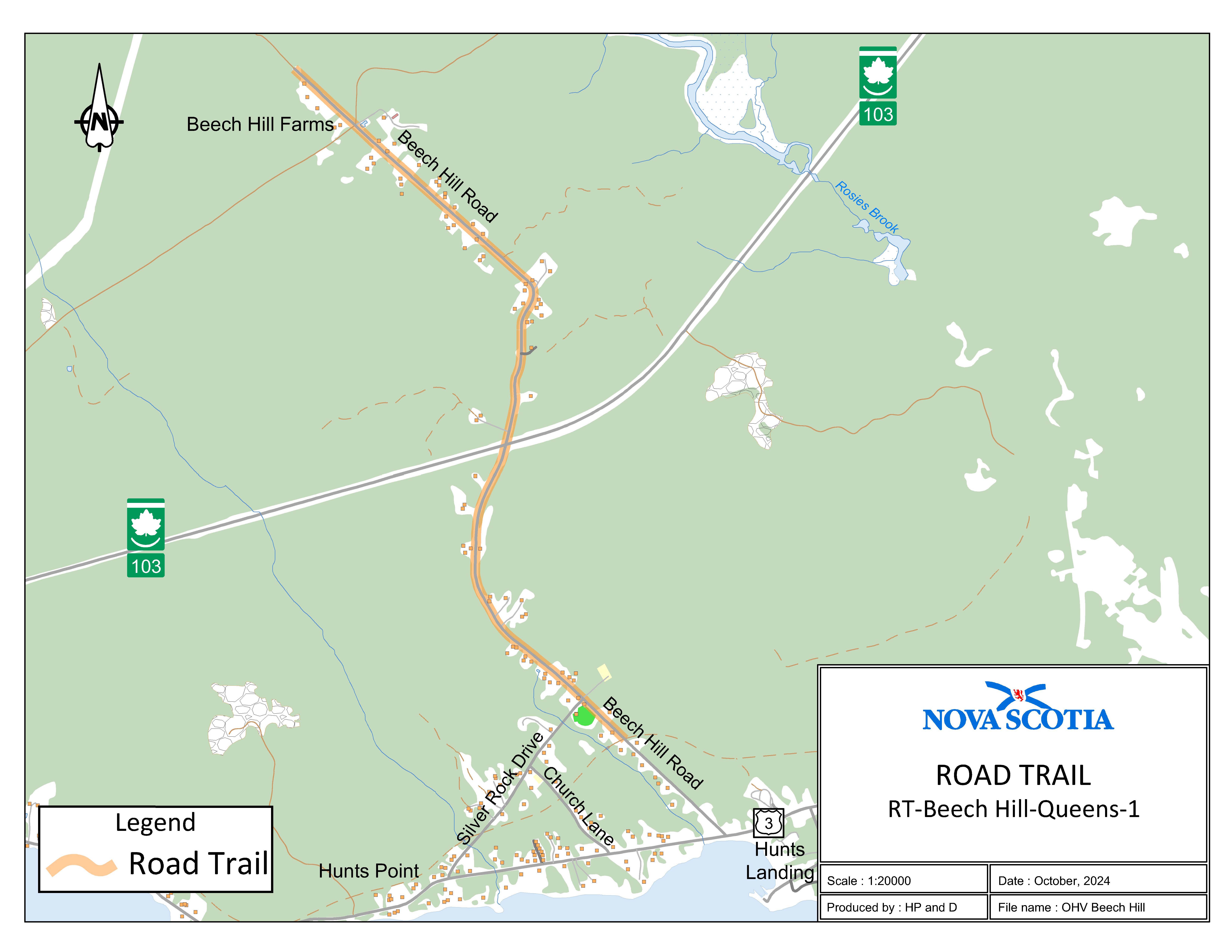
Appendix S: Beech Hill Road, Queens County
Appendix T: Summerville, Queens County
Appendix U: Bloomfield Cross Road, Digby County
Appendix V: Pubnico, Yarmouth County
Appendix W: Churchover, Shelburne County
Appendix X: Port Clyde, Shelburne County
Appendix Y: Spa Road, Shelburne County
Coordinates are decimal degrees map coordinates taken from Google Earth.
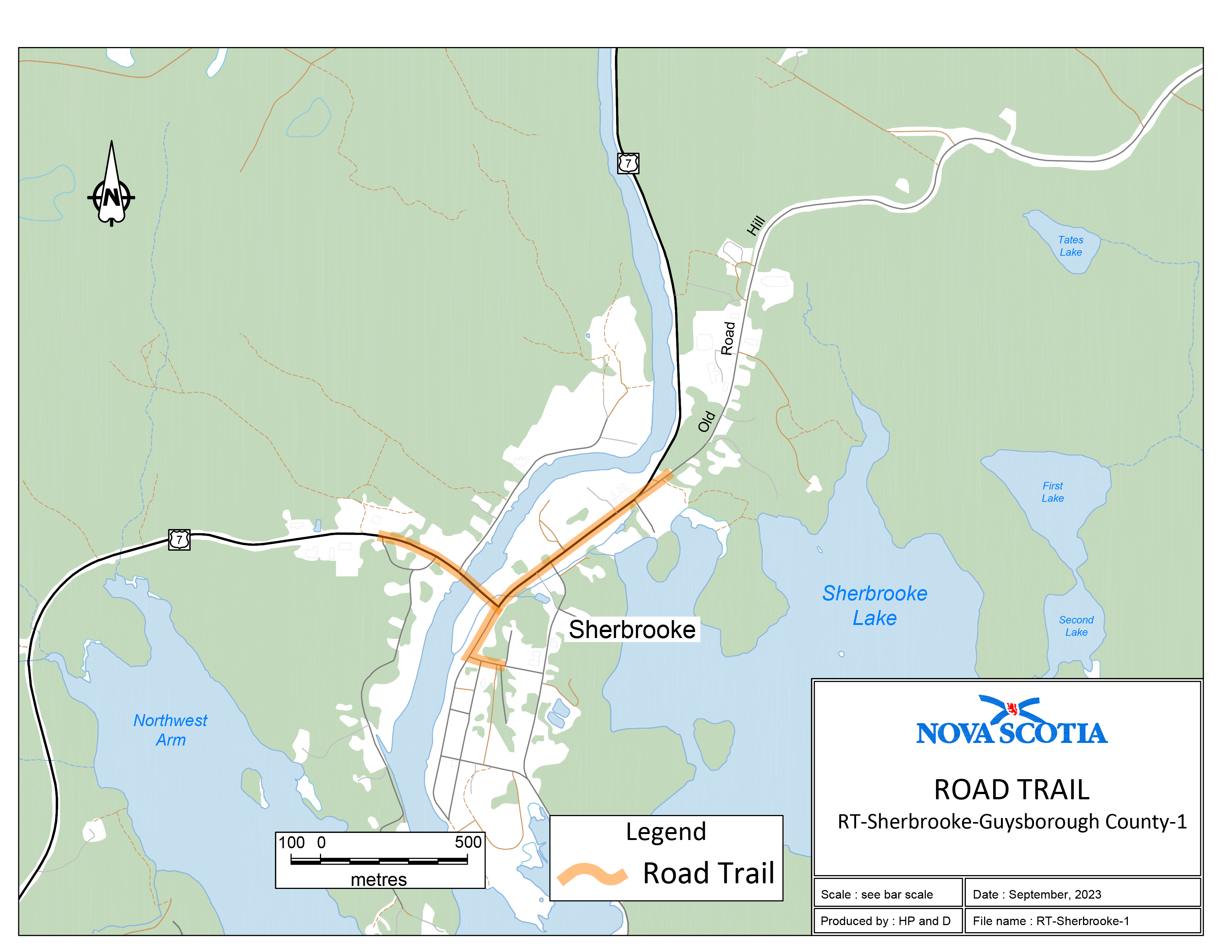
Appendix A: Trunk 7 Sherbrooke Village Inn
Two sections of road travel:
1. The road trail intersects with Highway 7 near Sherbrooke, Guysborough County, at coordinates 45.144697°N, 61.988007°W and travels in an easterly direction along Highway 7 for 830 m to the intersection of Highway 7 and Main Street. The road trail then travels northeast for 635 m to the intersection of Highway 7 and Old Road Hill. The road trail then travels northeast along Old Road Hill for 100 m to the intersection of Old Road Hill and the existing trail to coordinates 45.1465781°N, 61.975474°W.
2. The road trail begins at the intersection of Highway 7 and Main Street and travels southwest along Main Street to the intersection of Main Street and Court Street. The road trail then travels east along Court Street for 90 m from the intersection of Main Street and Court Street to coordinates 45.140585°N, 61.982679°W.
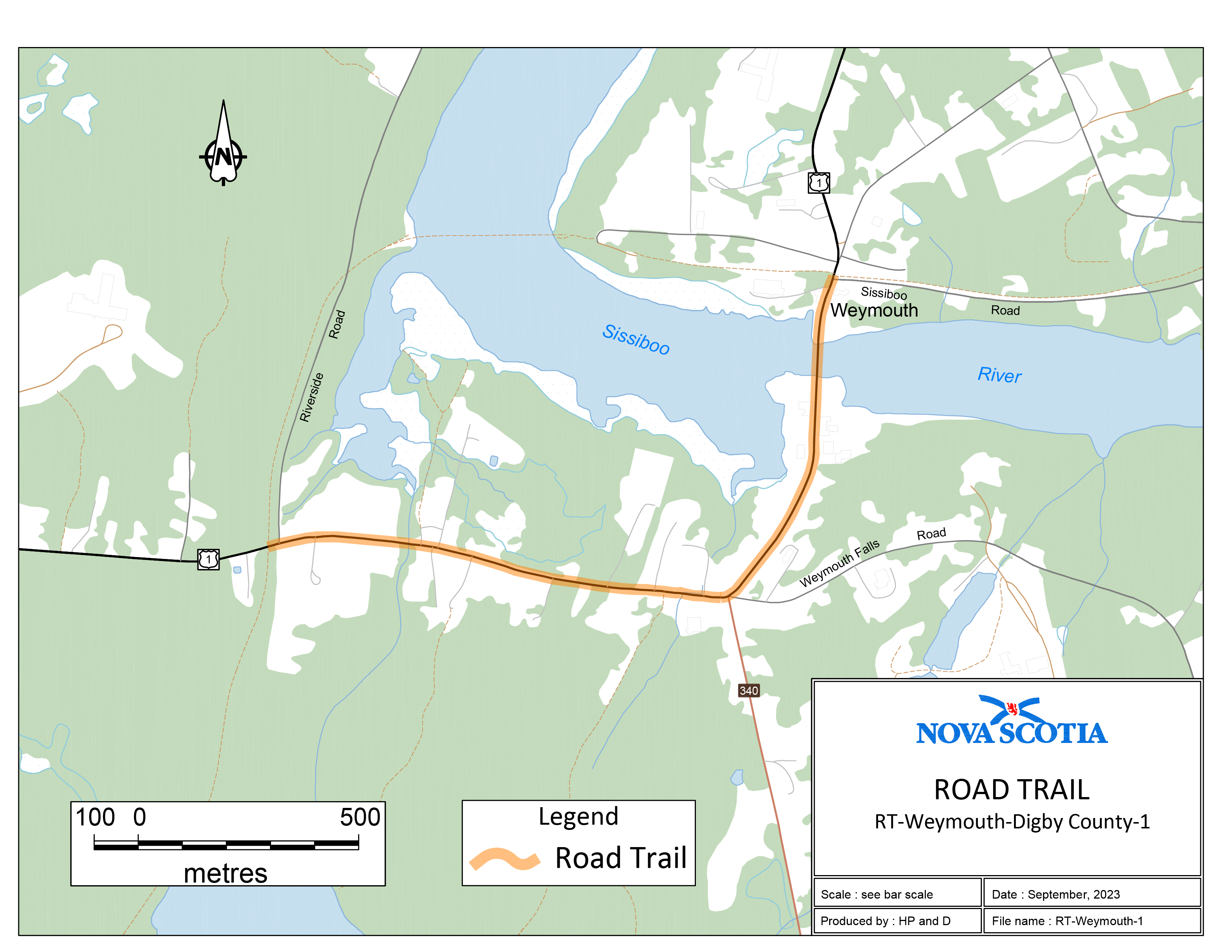
Trail begins where the former rail bed intersects with Highway 1, north of Weymouth, Digby County, at coordinates 44.405798°N, 66.011676°W. Then 810 m along Highway 1 to the intersection of Route 340, Weymouth Falls Road and Highway 1. Then westerly, 1060 m along Highway 1 to the intersection of existing trail on [the] former rail bed at coordinates 44.411654°N, 65.995797°W.
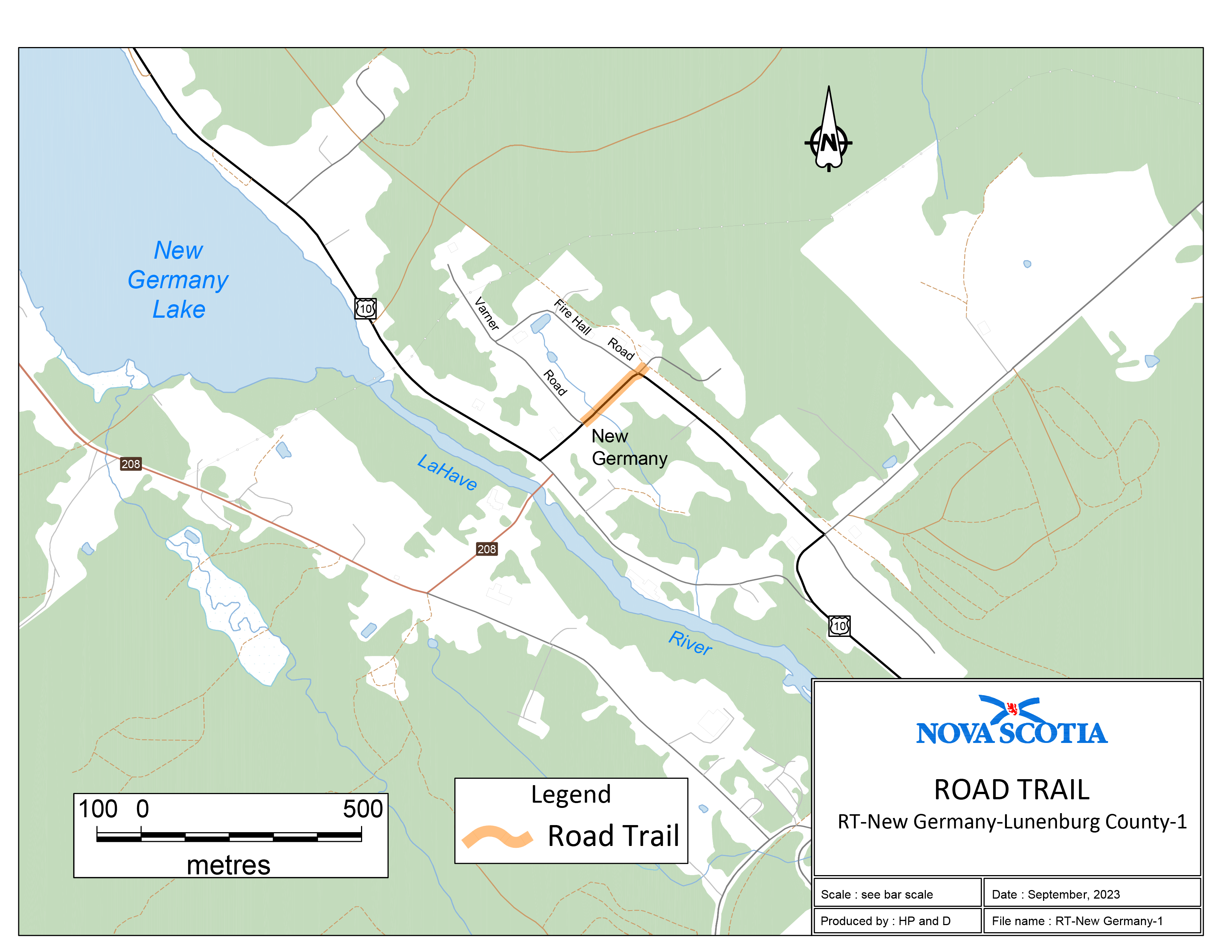
Trail begins where the former rail bed intersects with Maple Drive, New Germany (near Fire Hall), Lunenburg County, at coordinates 44.547502°N, 64.722695°W. Then southwest crossing Highway 10 and travelling 210 m to the intersection of Highway 10 and Varner Road at coordinates 44.546265°N, 64.724589°W.
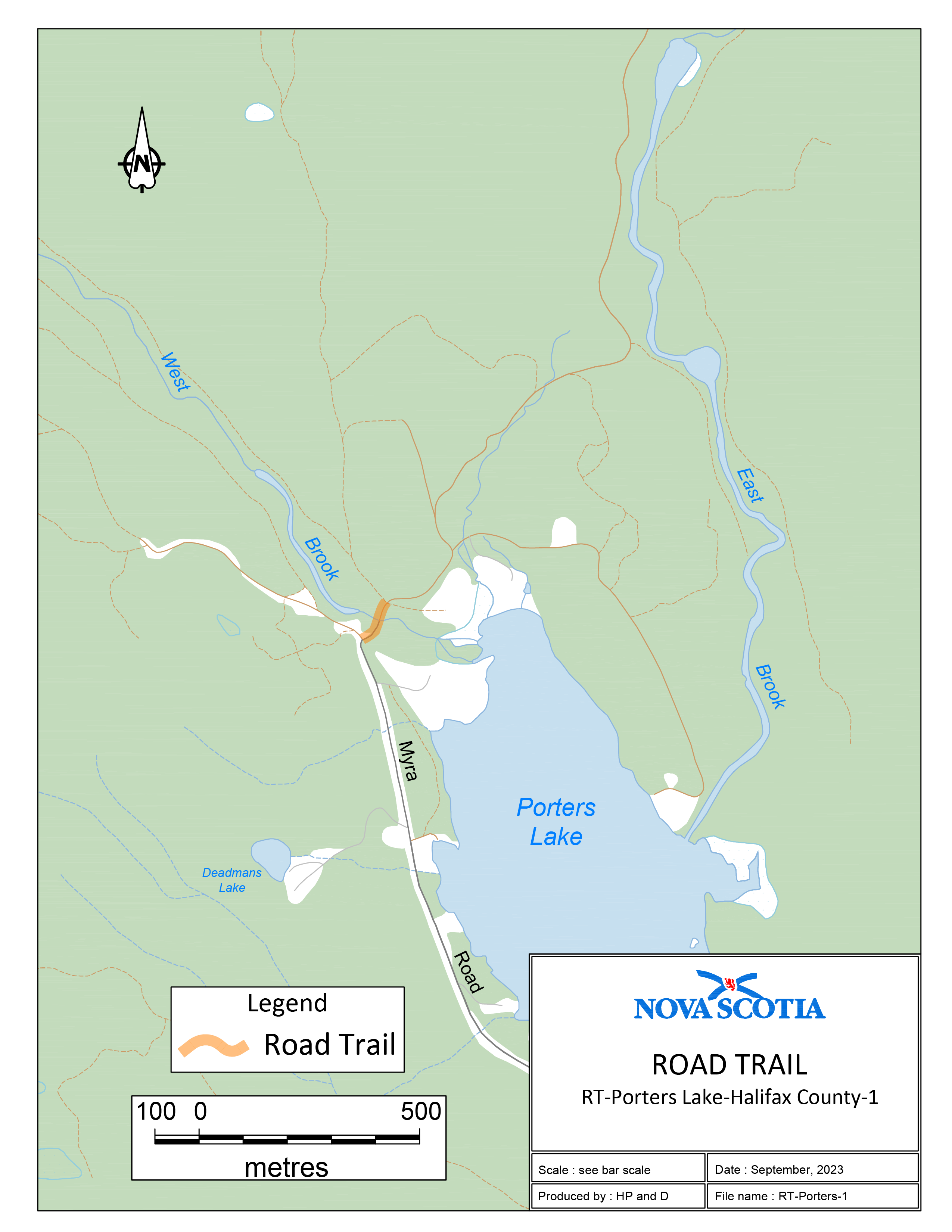
Beginning at a point on the Myra Road, Porters Lake, Halifax County, coordinates 44.808262°N, 63.385073°W and travelling in a northerly direction for 110 m to an existing trail at 44.809038°N, 63.384350°W.
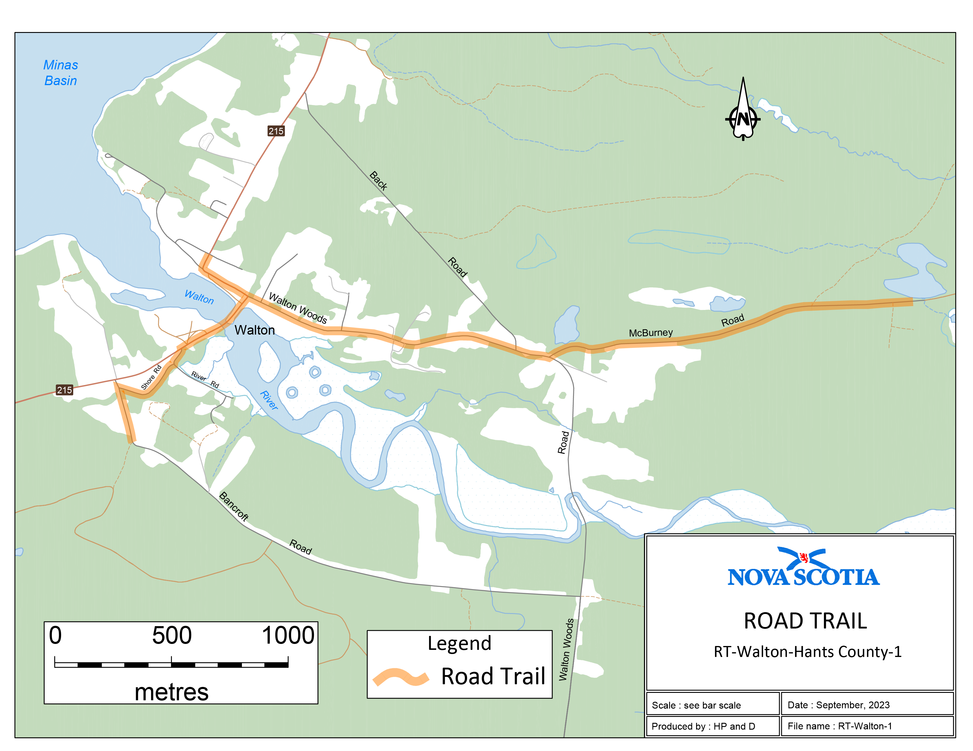
Two sections of road travel:
1. Trail intersects with the Bancroft Road near Walton, Hants County, at coordinates 45.223205°N, 64.010301°W. Then north 250 m, along the Bancroft Road to the intersection of the Shore Road, then 375 m along the Shore Road to the intersection of Route 215. Then northeast along Route 215, 365 m to the intersection of the Walton Woods Road. Then easterly along the Walton Woods Road 1340 m to the intersection of the McBurney Road, then 1600 m along McBurney Road to coordinates 45.228497°N, 63.967040°W.
2. Beginning at the intersection of Route 215 and Walton Woods Road, then northwest along Route 215, 290 m to the intersection of Route 215 and Odd Fellows Hall Road, coordinates 45.230406°N, 64.006121°W.
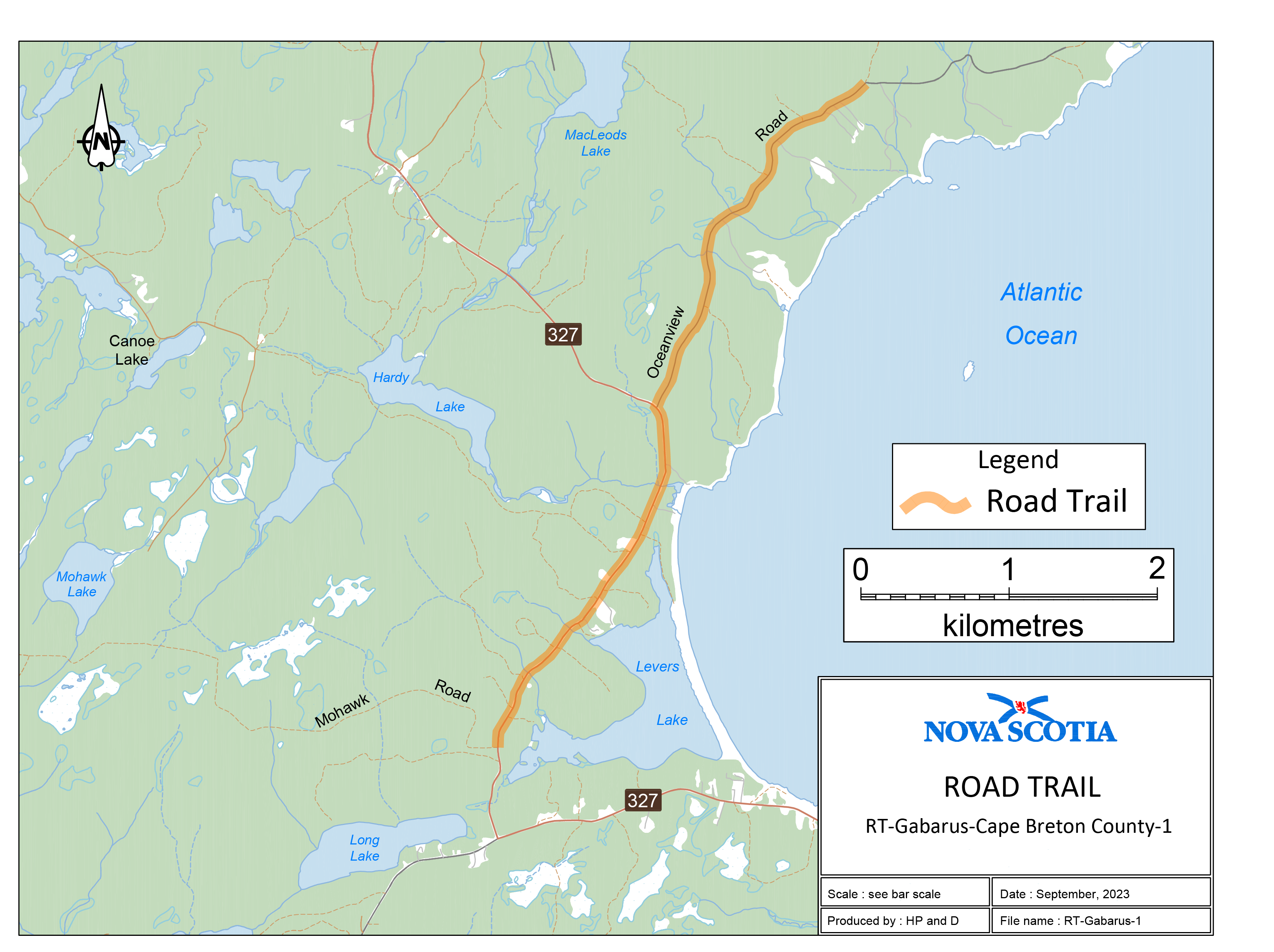
Trail begins where a K-class road intersects with Oceanview Road at 45.882330°N, 60.156693°W, and travelling in a southerly direction along Oceanview Road, 2822 m to the intersection of Oceanview Road and Route 327. Then southerly along Route 327, 2667 m to the intersection of Route 327 and a Crown road (Mohawk Road) at 45.842191°N, 60.189473°W.
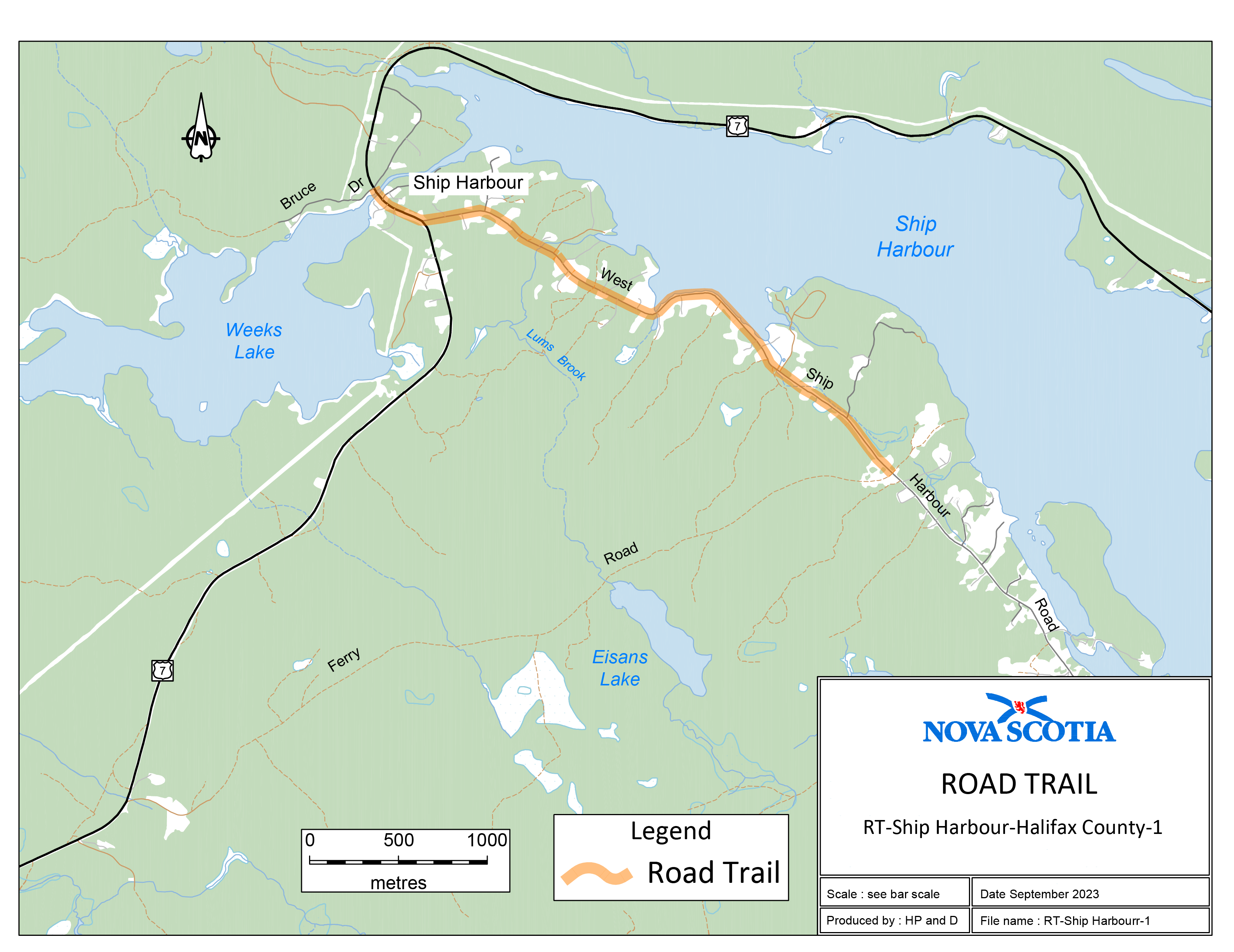
Trail begins at the location where Ferry Road (K-class road) intersects with West Ship Harbour Road at coordinates 44.795386°N, 62.848750°W. Then 3300 m in a northwesterly direction along West Ship Harbour Road and Trunk 7. Then 340 m northwesterly along Trunk 7 to the intersection of Trunk 7 and Bruce Drive (a private lane) at coordinates 44.809451°N, 62.886036°W.
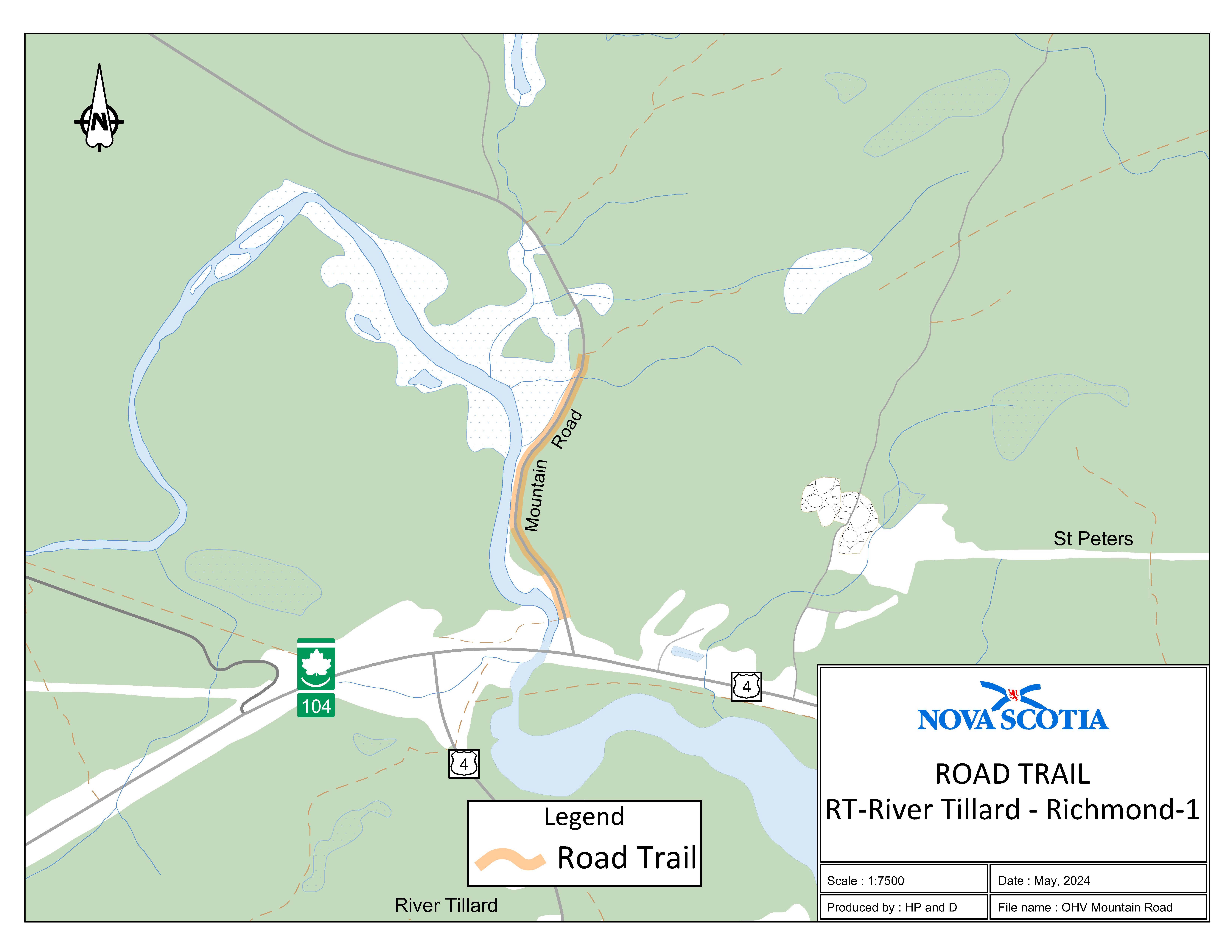
Appendix H: Mountain Road, St. Peters
The road trail begins at the intersection of the rail trail and Mountain Road, a gravel road with an unposted speed limit of 80 km/h, at coordinates 45.657544°N, 60.912829°W, and travels south along Mountain Road for 0.53 km to the intersection of Mountain Road and Trail 62.
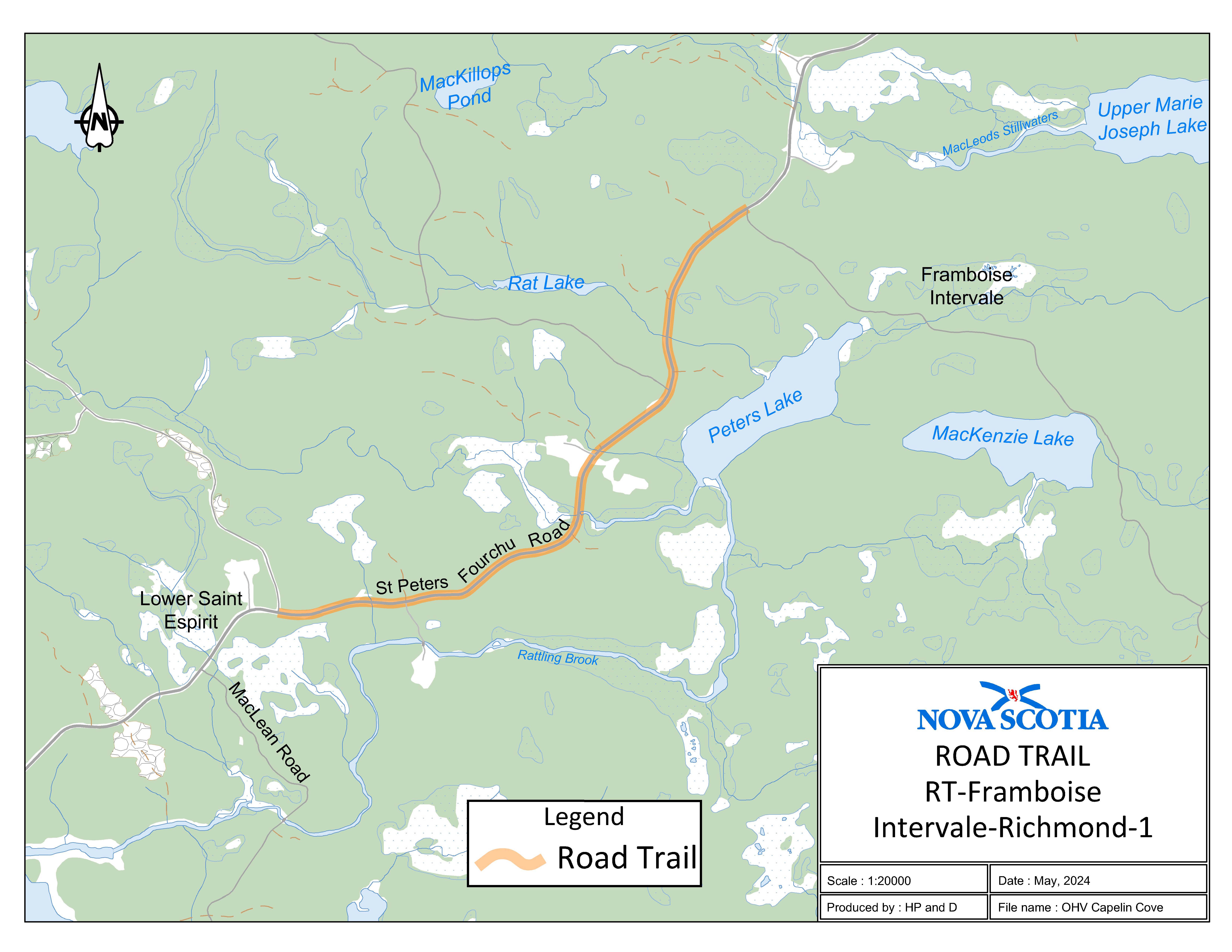
Appendix I: Capelin Cove, Richmond County
The road trail begins at the intersection of St. Peters Fourchu Road and the Capelin Cove Road Trailhead at coordinates 45.686306°N, 60.448473°W and travels east on St. Peters Fourchu Road for 3.25 km to the intersection of St. Peters Fourchu Road and the St. Esprit Road Trailhead.
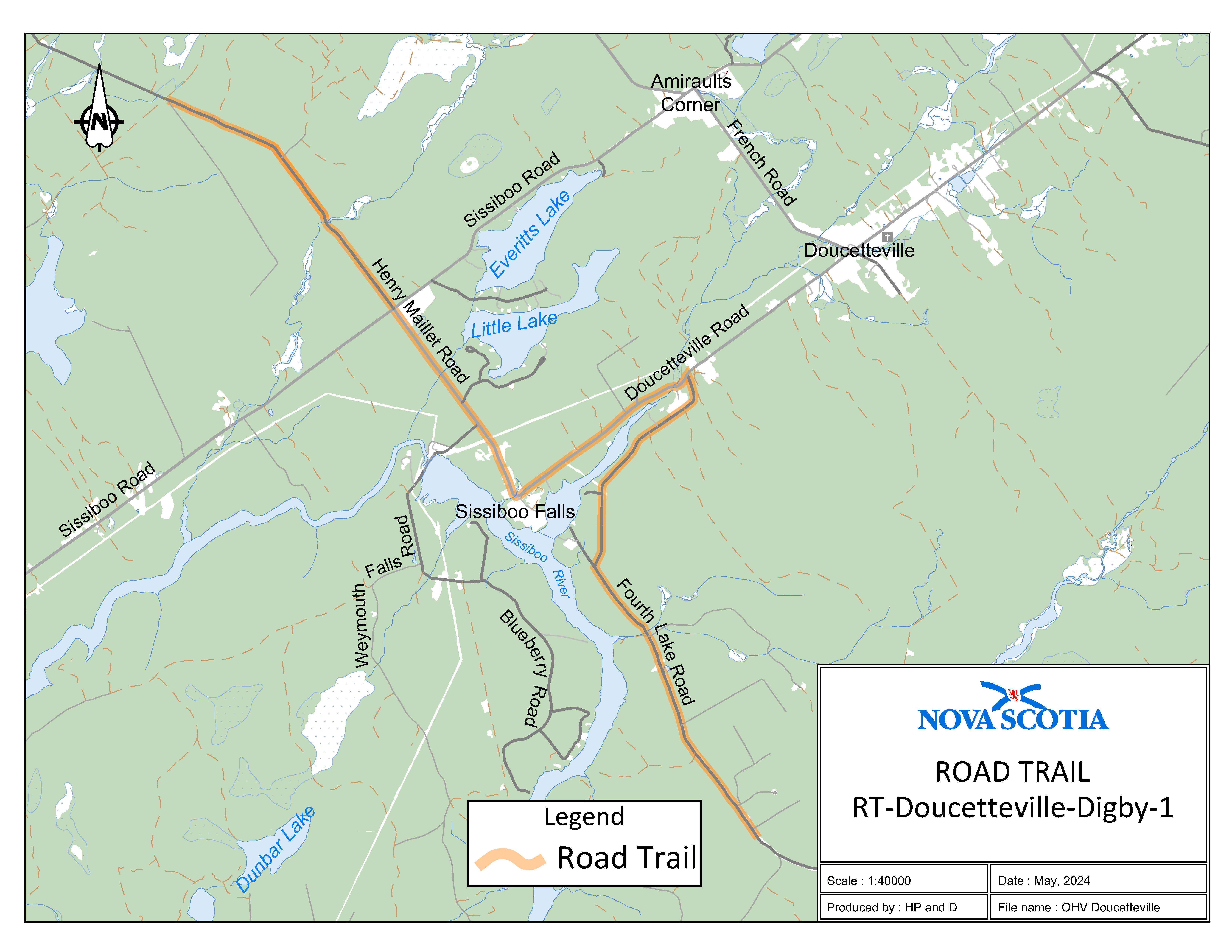
Appendix J: Doucetteville, Digby County
Three sections of road travel:
1. The road trail begins at the intersection of Henry Maillet Road and the rail trail at coordinates 44.459454°N, 65.902948°W and travels 2.9 km on Henry Maillet Road to the intersection of Henry Maillet Road and Sissiboo Road. The road trail continues on Henry Maillet Road from the intersection of Henry Maillet Road and Sissiboo Road and travels 2.04 km to the intersection of Henry Maillet Road and Doucetteville Road.
2. The road trail continues on Doucetteville Road from the intersection of Henry Maillet Road and Doucetteville Road and travels 1.9 km to the intersection of Doucetteville Road and Fourth Lake Road.
3. The road trail continues on Fourth Lake Road from the intersection of Doucetteville Road and Fourth Lake Road and travels 5.05 km to the end of Fourth Lake Road to coordinates 44.400604°N, 65.834440°W.
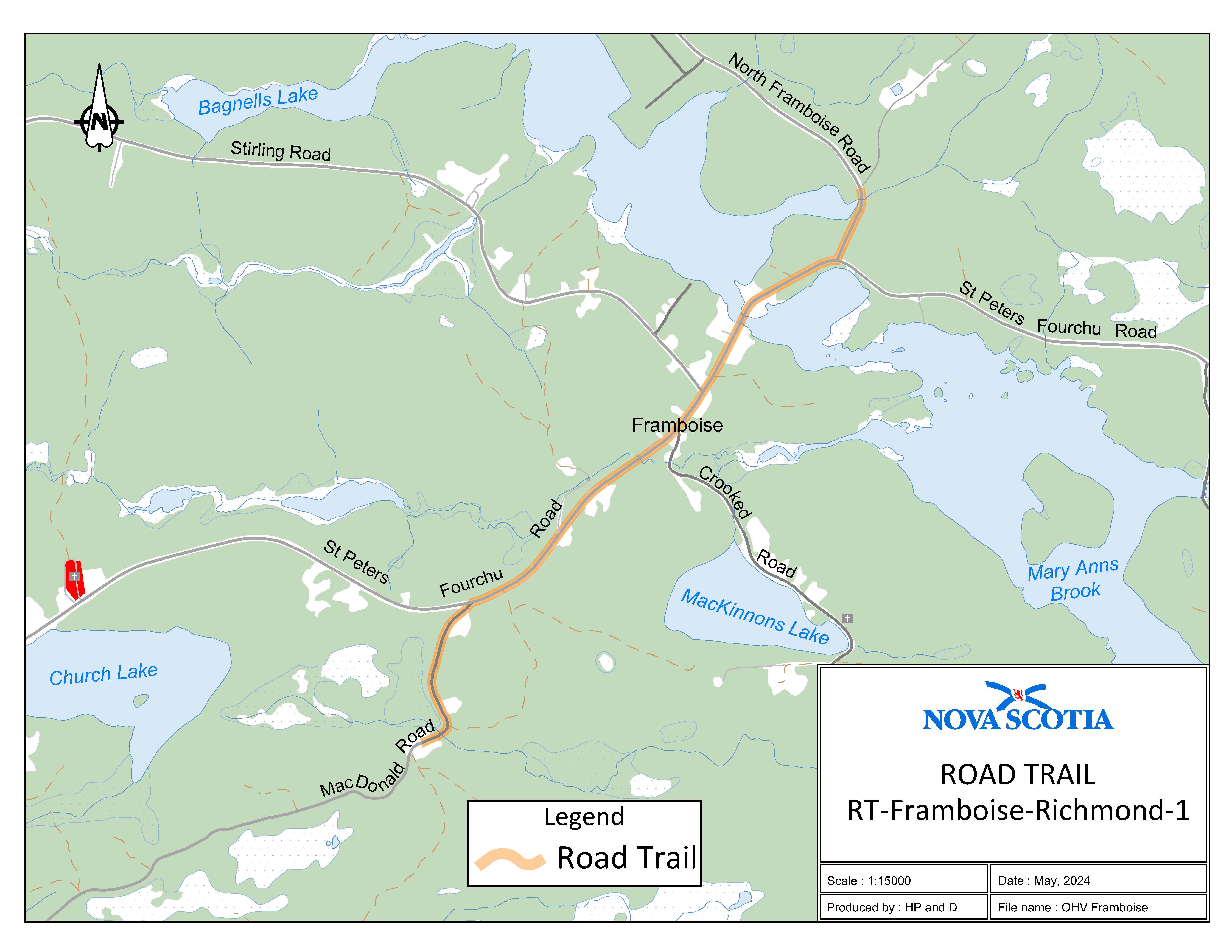
Appendix K: Framboise, Richmond County
Three sections of road travel:
1. The road trail begins on MacDonald Road at coordinates 45.709206°N, 60.375196°W and travels north on MacDonald Road for 0.64 km to the intersection of MacDonald Road and St. Peters Fourchu Road.
2. The road trail continues on St. Peters Fourchu Road from the intersection of St. Peters Fourchu Road and MacDonald Road and travels for 1.75 km to the intersection of St. Peters Fourchu Road and North Framboise Road.
3. The road trail continues on North Framboise Road from the intersection of St. Peters Fourchu Road and North Framboise Road and travels north for 0.27 km to the intersection of North Framboise Road and Trail 652 at coordinates 45.726071°N, 60.355583°W.
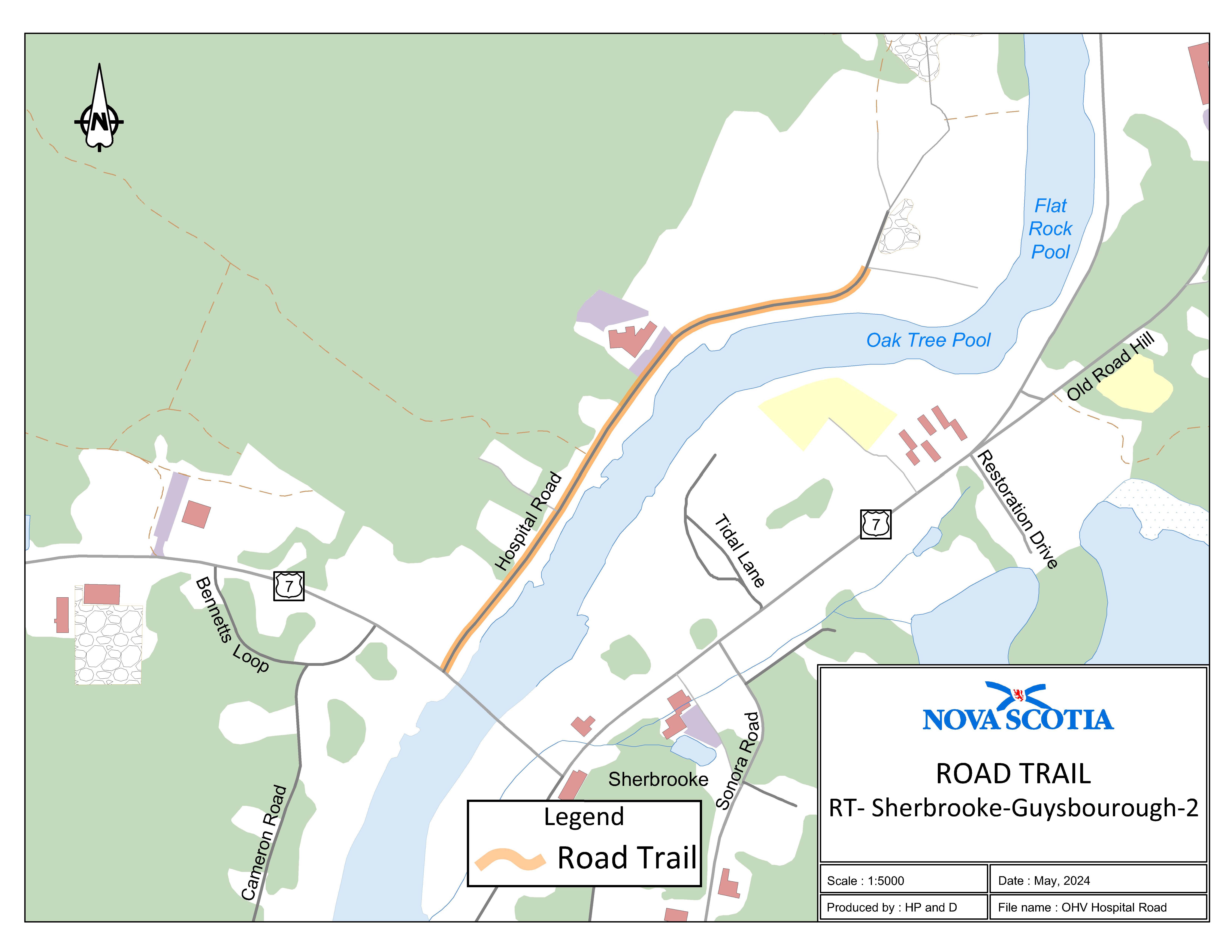
Appendix L: Hospital Road (Sherbrooke, Guysborough County)
The road trail begins at the intersection of Hospital Road and Trunk 7 at coordinates 45.143579°N, 61.984493°W and travels 0.8 km to civic number 150 Hospital Road.
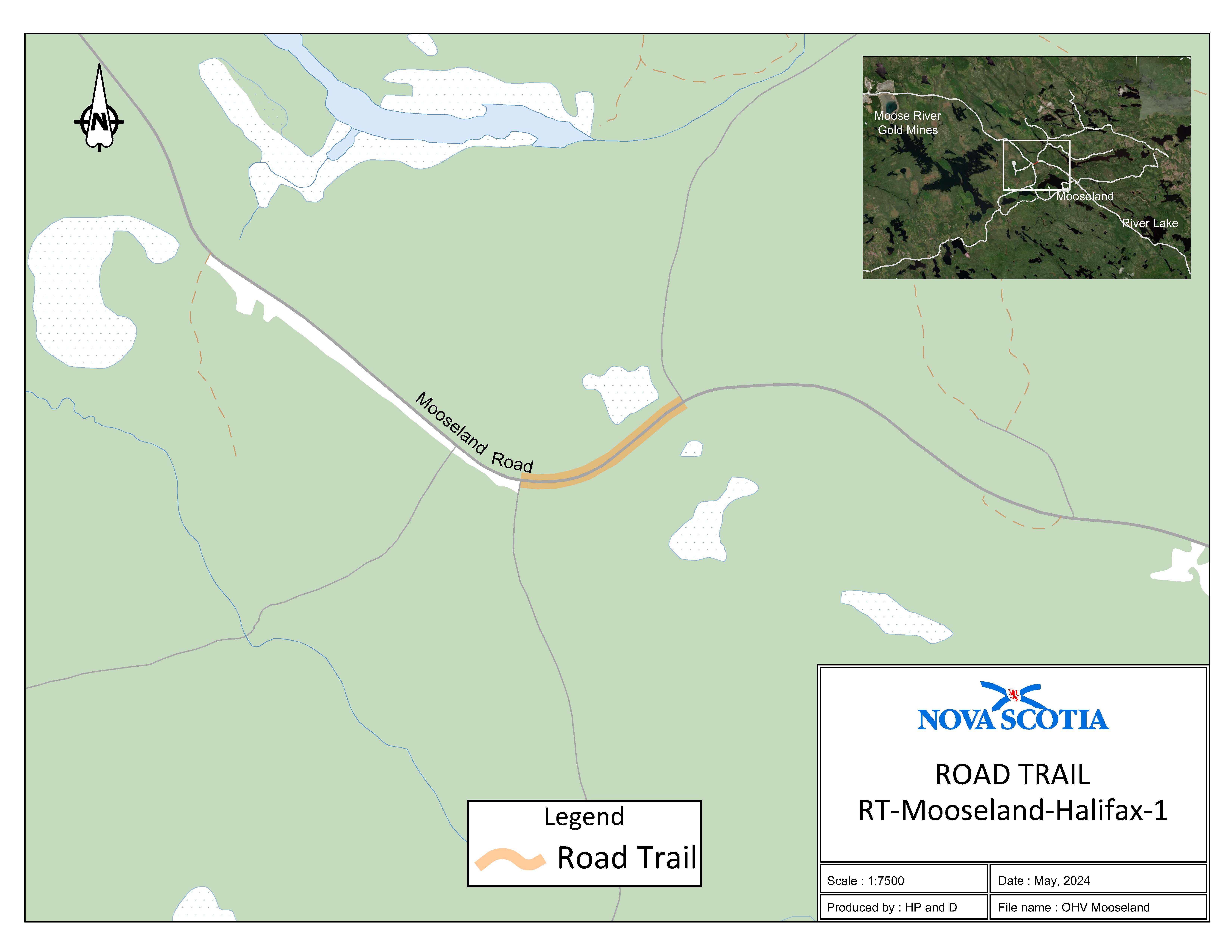
Appendix M: Mooseland, Halifax Regional Municipality
The road trail begins at the intersection of Trail 105 and Mooseland Road, Halifax County, at coordinates 44.955069°N, 62.820712°W and travels north on Mooseland Road for 0.3 km to the intersection of Mooseland Road and Trail 106 at coordinates 44.953820°N, 62.824220°W.
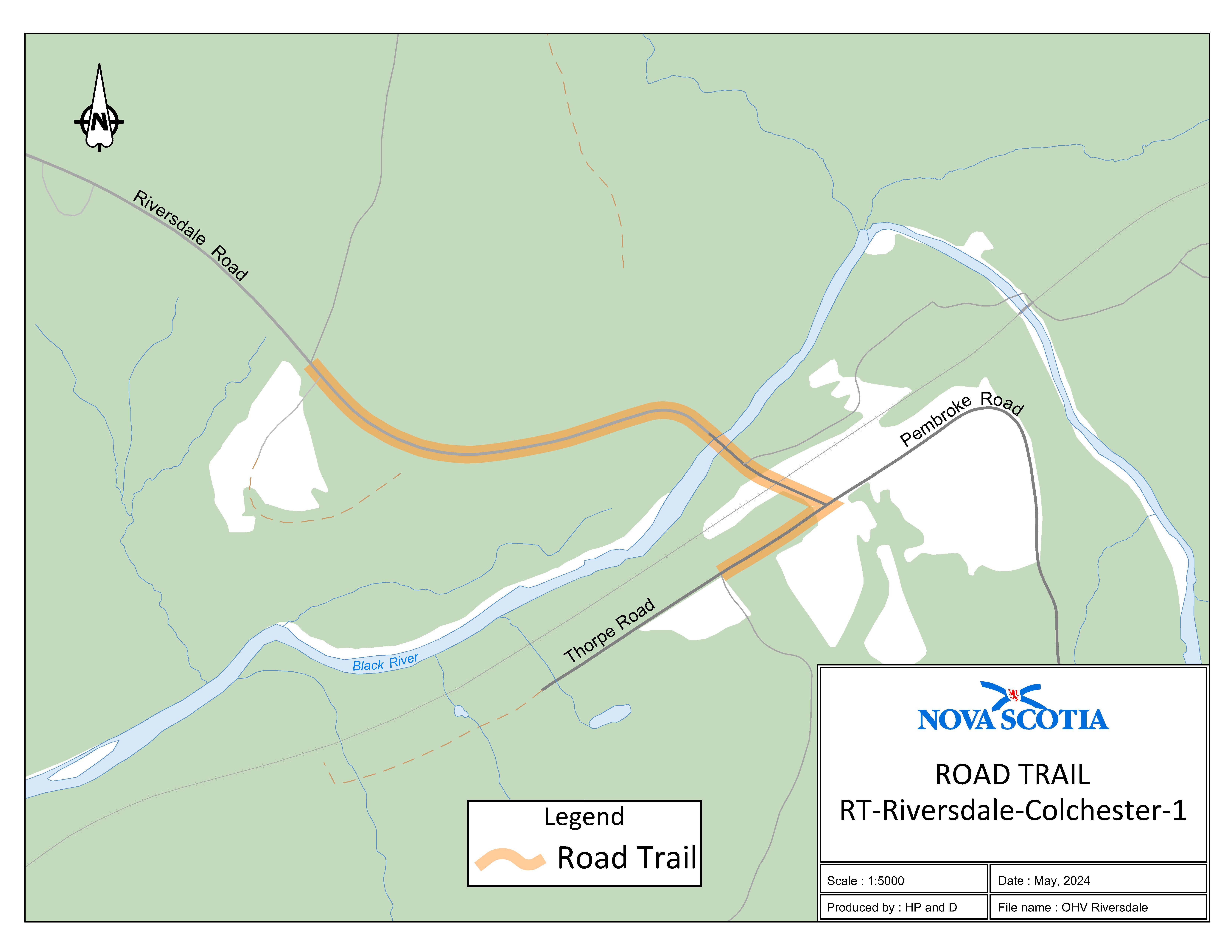
Appendix N: Riversdale, Colchester County
Two sections of road travel:
1. The road trail begins at the intersection of Riversdale Road and Trail 104 at coordinates 45.424525°N, 63.052559°W and travels northeast for 0.66 km to the intersection of Riversdale Road and Thorpe Road.
2. The road trail continues on Thorpe Road from the intersection of Thorpe Road and Riversdale Road and travels southwest for 0.15 km to the intersection of Thorpe Road and Trail 496 at coordinates 45.422343°N, 63.046667°W.
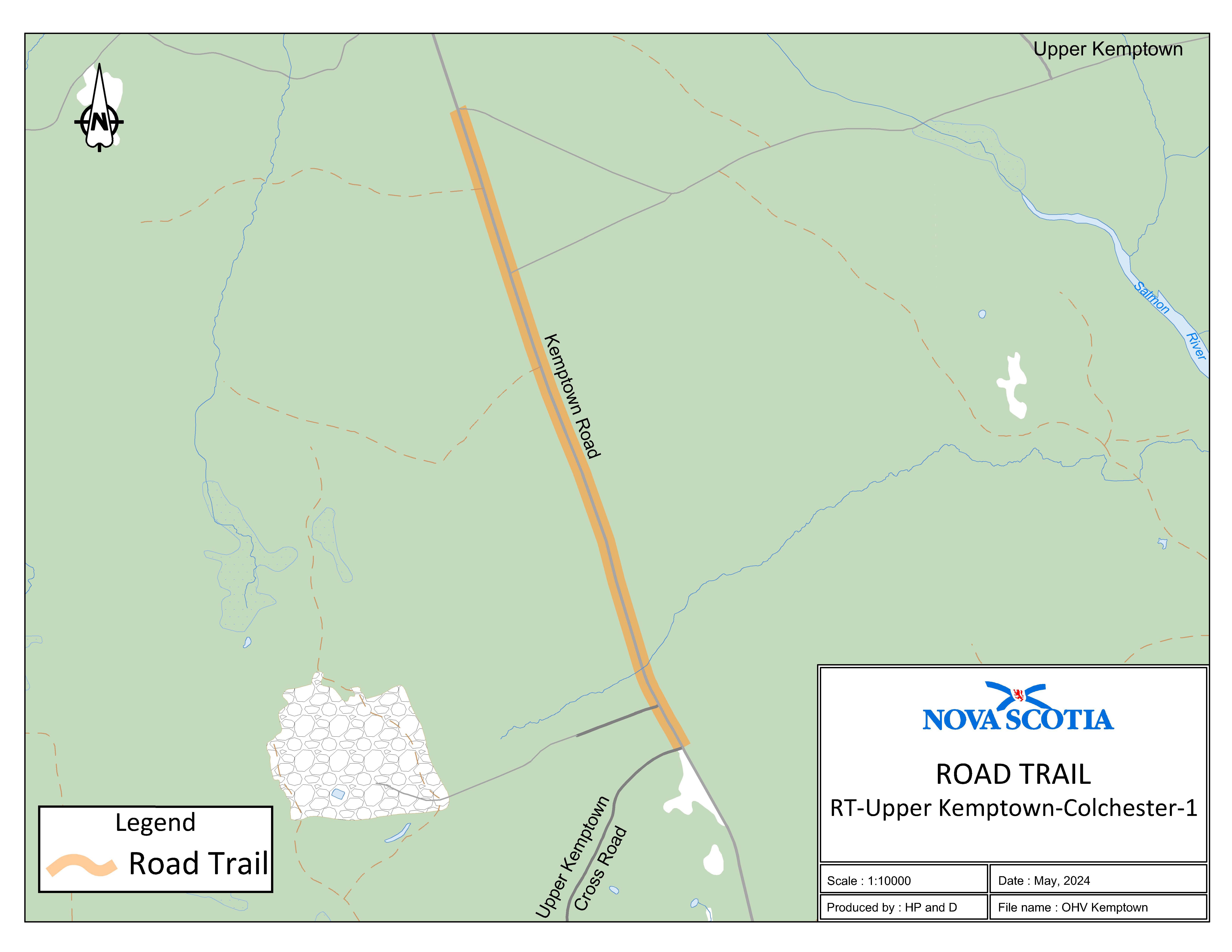
Appendix O: Kemptown, Colchester County
The road trail begins at the intersection of Kemptown Road and Upper Kemptown Cross Road at coordinates 45.525926°N, 63.107645°W and travels north on Kempton Road for 1.55 km to the intersection of Kempton Road and Trail 104 Trailhead at coordinates 45.539069°N, 63.113812°W.
Appendix P: Route 308 (Tusket, Yarmouth County)
Effective July 9, 2026, Appendix P is replaced by N.S. Reg. 164/2026.
The road trail begins at civic number 4023 on Route 308 at coordinates 43.862052°N, 65.972857°W and travels north on Route 308 for 0.55 km to civic number 4137 on Route 308. The road trail then connects to the rail trail.
Appendix Q: Lennox Passage, Richmond County
The road trail begins at the intersection of the Richmond County Rail Trail and Route 320 at coordinates 45.620859°N, 61.060233°W and travels south to the Louisdale Connector for a distance of 3.36 km. The road trail continues on Route 320 from the Louisdale Connector to Route 206 for a distance of 4.33 km. The road trail continues on Route 206 from Route 320 to Rogers Road for a distance of 0.13 km. The road trail continues on Rogers Road from Route 206 to Rogers Road (K section) for a distance of 0.37 km.
Appendix R: Margaree Centre, Inverness County
The road trail begins at civic number 27 Cranton Crossing Road at coordinates 46.342057°N, 60.995968°W and travels north for a distance of 0.64 km. The road trail continues on West Big Intervale Road from the intersection of Cranton Crossing Road and West Big Intervale Road until civic number 1316 West Big Intervale Road at coordinates 46.339900°N, 61.017156°W for a distance of 1.6 km.
Appendix S: Beech Hill Road, Queens County
The road trail begins adjacent to civic number 115 on Beech Hill Road at coordinates 43.957777°N, 64.775868°W and travels northwest through the Highway 103 underpass and terminates at the Queens County Rail Trail on Crown land at coordinates 43.985066°N, 64.794630°W. The total distance is 3.84 km.
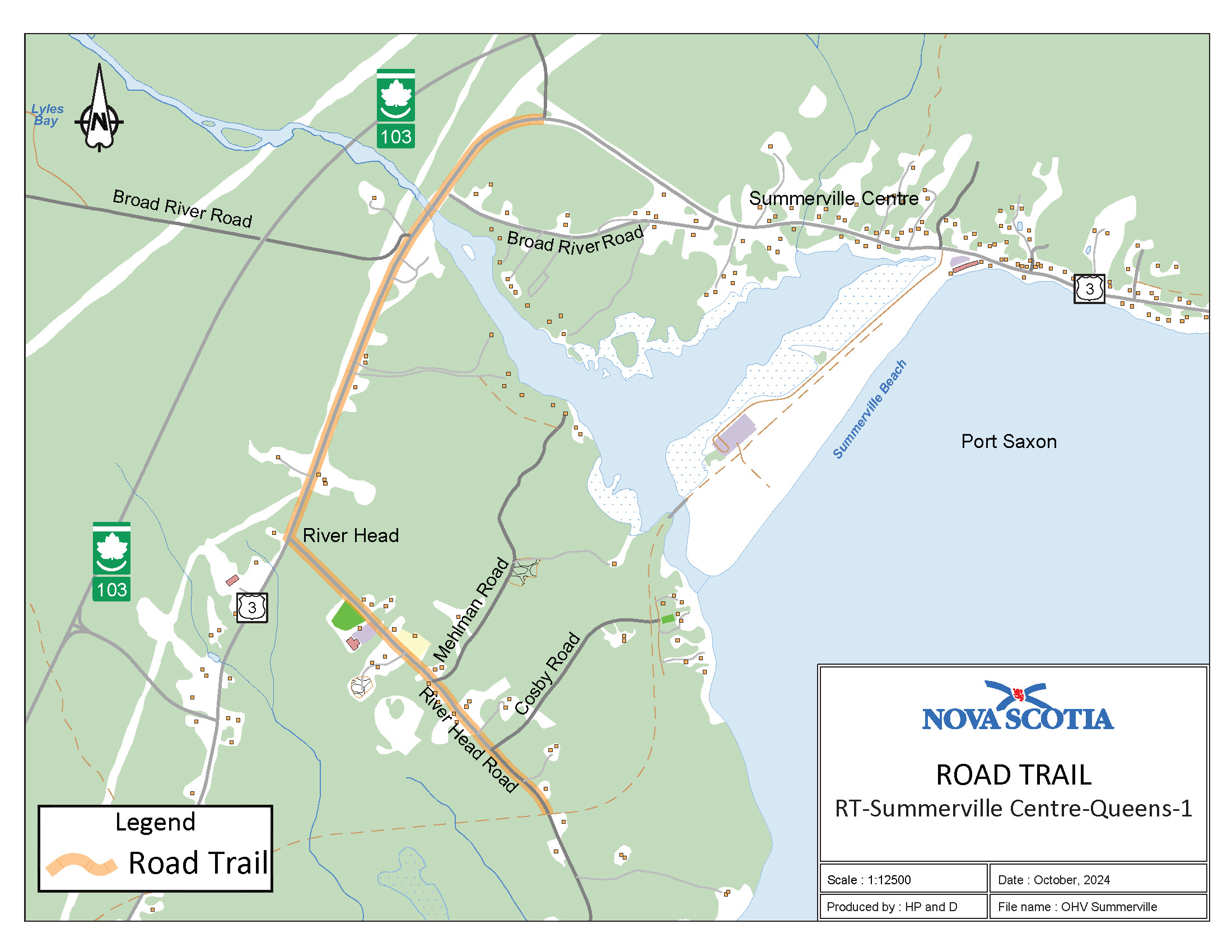
Appendix T: Summerville, Queens County
The road trail begins at the intersection of Trunk 3 and Old Port Mouton Road (K-class road) at coordinates 43.957833°N, 64.828901°W and travels southeast for a distance of 1.5 km. The road trail continues on River Head Road from the intersection of River Head Road and Trunk 3 until adjacent to civic number 203 River Head Road at coordinates 43.940081°N, 64.828697°W for a distance of 1.1 km.
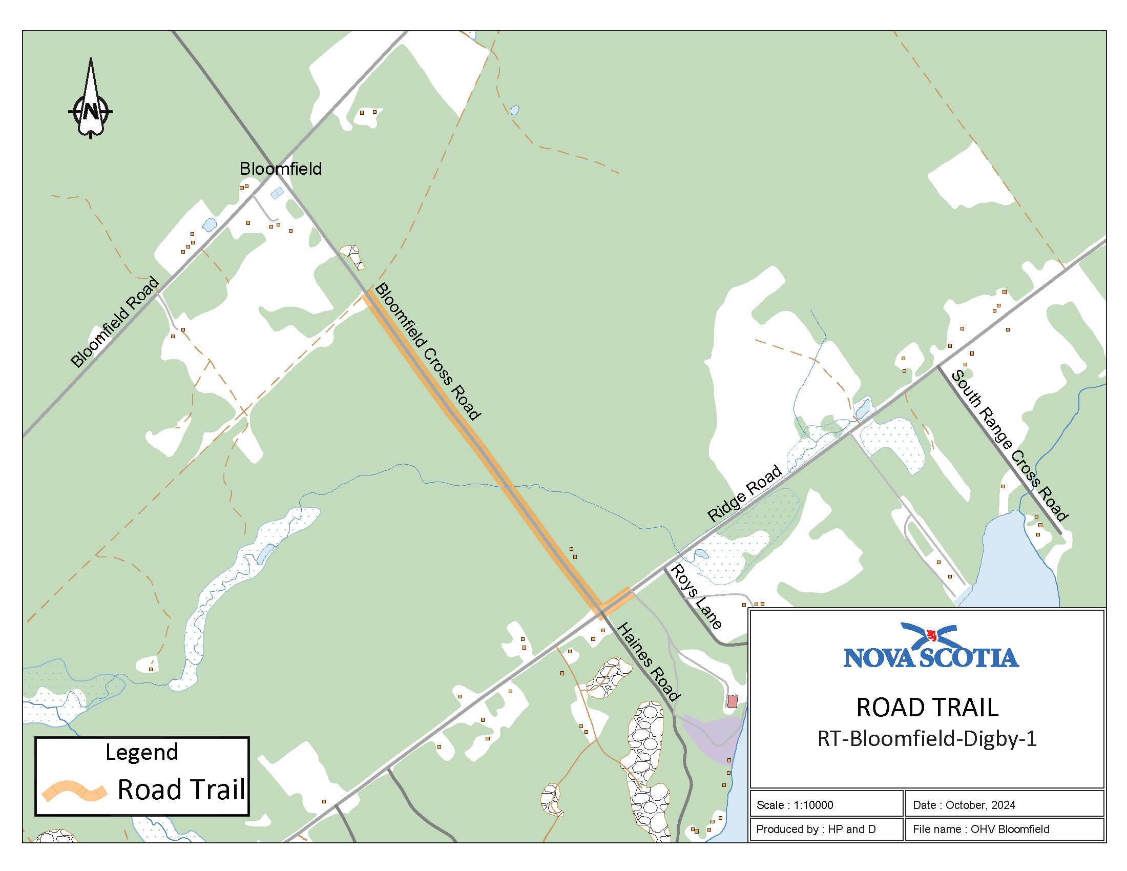
Appendix U: Bloomfield Cross Road, Digby County
The road trail begins adjacent to civic number 478 Bloomfield Road at coordinates 44.527923°N, 65.824999°W. It then turns on to Bloomfield Cross Road and travels southeast for a distance of 0.99 km. The road trail continues on Ridge Road from the intersection of Bloomfield Cross Road and Ridge Road and ends at coordinates 44.520031°N, 65.813272°W for a distance of 0.1 km.
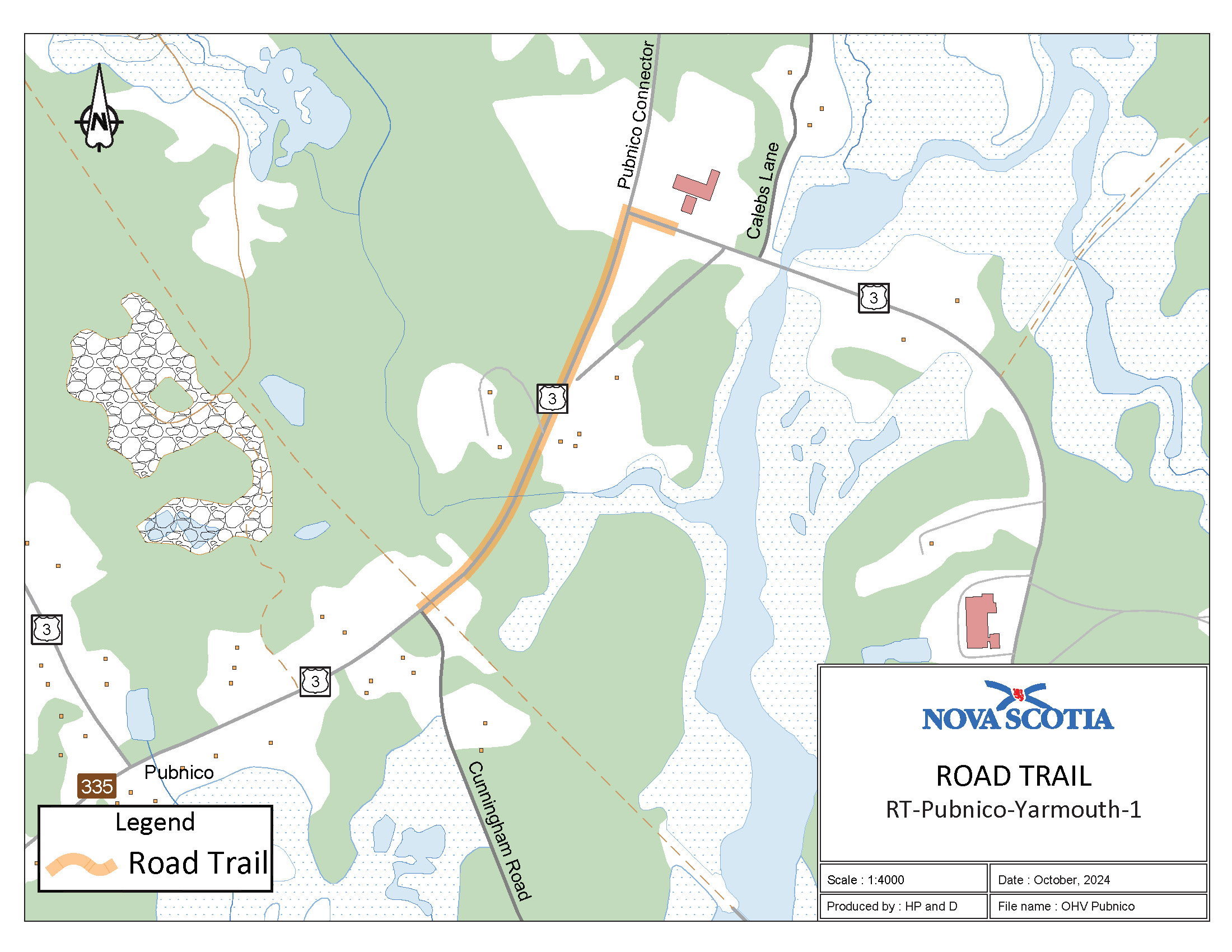
Appendix V: Pubnico, Yarmouth County
The road trail begins on Trunk 3 adjacent to Cunningham Road at coordinates 43.703757°N, 65.780940°W and goes easterly on Trunk 3 for a distance of 0.45 km.
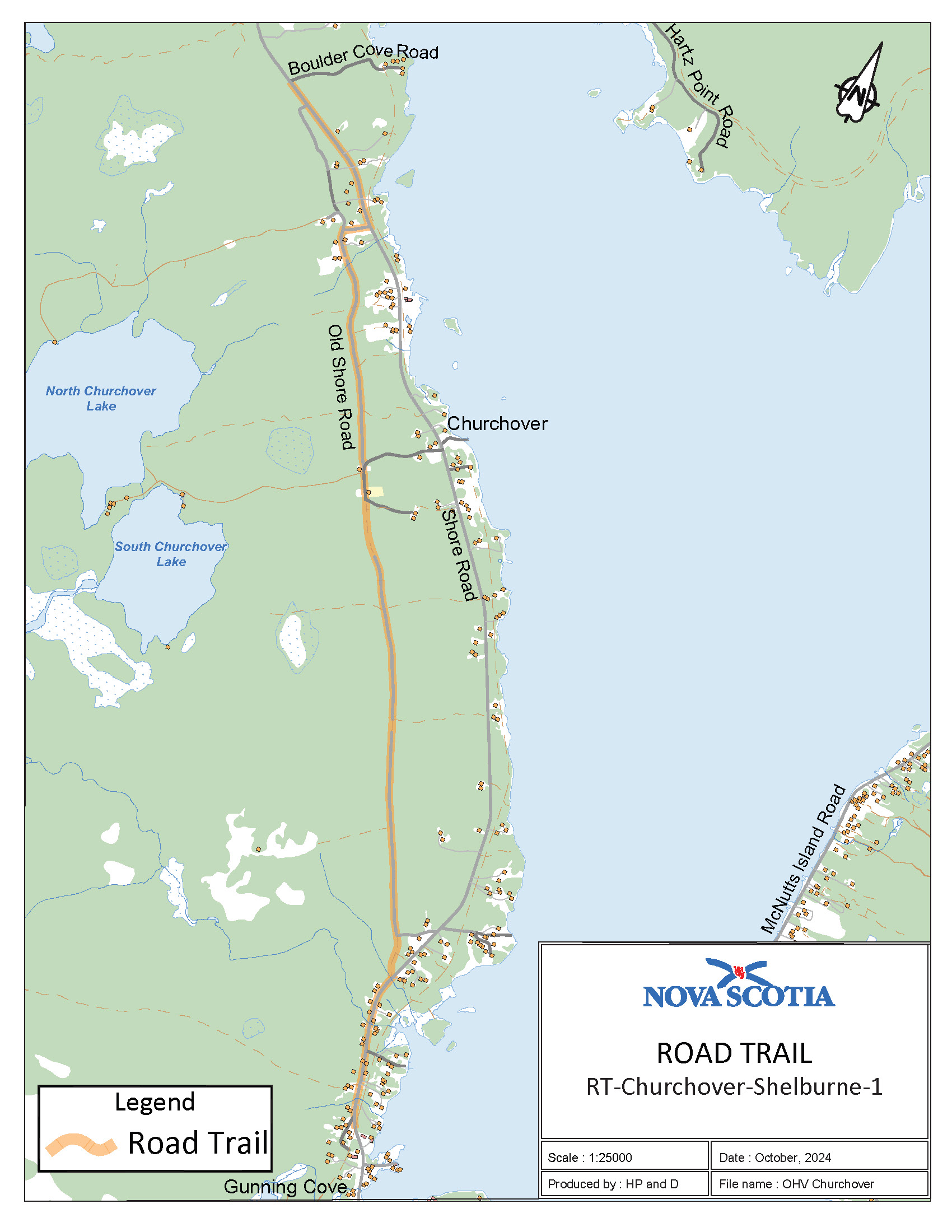
Appendix W: Churchover, Shelburne County
The road trail begins at the intersection of Boulder Cove Road and Shore Road at coordinates 43.727899°N, 65.379813°W and goes southeast on Shore Road for a distance of 0.96 km. The road trail continues on Shore Road where it meets Gouldens Road at coordinates 43.722814°N, 65.370528°W and continues on Gouldens Road going southeast for a distance of 0.15 km. The road trail goes from where Gouldens Road meets Old Shore Road at coordinates 43.720804°N, 65.370969°W and then continues on Old Shore Road for a distance of 0.35 km. The road trail goes from where Old Shore Road meets Shore Road and then continues on Shore Road for a distance of 0.9 km.
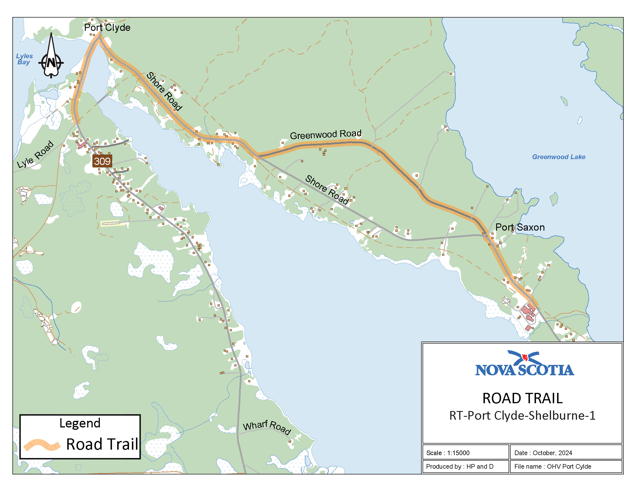
Appendix X: Port Clyde, Shelburne County
The road trail begins at the intersection of Route 309 (Port LaTour Road) and Lyle Road at coordinates 43.600270°N, 65.469576°W and goes northeast on Route 309 for a distance of 0.60 km. The road trail follows Route 309 where it intersects with Shore Road at coordinates 43.605088°N, 65.467771°W and continues on Shore Road going southeast for a distance of 1.36 km. The road trail intersects with Greenwood Road at coordinates 43.598507°N, 65.454502°W and then continues on Greenwood Road for a distance of 1.65 km. The road trail continues on Shore Road for a distance of 0.56 km.
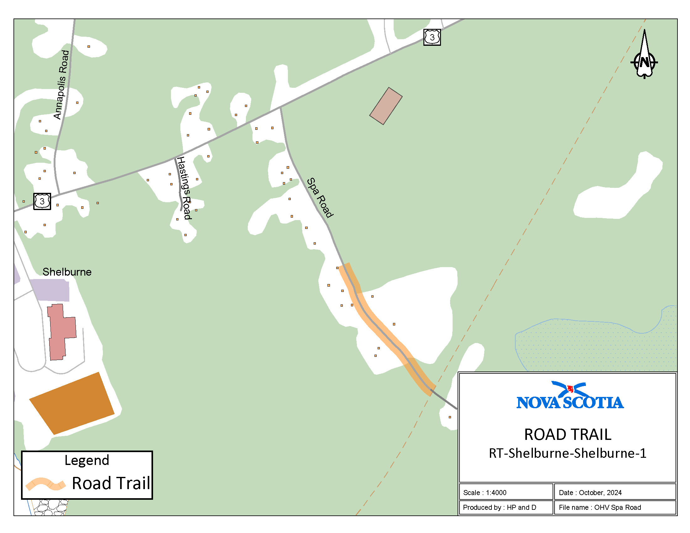
Appendix Y: Spa Road, Shelburne County
The road trail begins at the end of the municipal section of Spa Road and goes southeast on Spa Road until it meets the Shelburne County Rail Trail at coordinates 43.764943°N, 65.301209°W for a distance of 0.32 km.