| This consolidation is unofficial and is for reference only. For the official version of the regulations, consult the original documents on file with the Office of the Registrar of Regulations, or refer to the Royal Gazette Part II. |
| Regulations are amended frequently. Please check the list of Regulations by Act to see if there are any recent amendments to these regulations filed with our office that are not yet included in this consolidation. |
| Although every effort has been made to ensure the accuracy of this electronic version, the Office of the Registrar of Regulations assumes no responsibility for any discrepancies that may have resulted from reformatting. |
| This electronic version is copyright © , Province of Nova Scotia, all rights reserved. It is for your personal use and may not be copied for the purposes of resale in this or any other form. |
Road Trails Designation: Appendices AV - BV
Table of Contents
Please note: this table of contents is provided for convenience of reference and does not form part of the regulations.
Click here to return to the index of all road trails designations.
Appendix AV: Belliveaus Cove, Digby County
Appendix AW: Caledonia, Guysborough County
Appendix AX: Lower Caledonia, Guysborough County
Appendix AY: North East Margaree, Inverness County
Appendix AZ: Margaree Centre, Inverness County
Appendix BA: Glenelg, Guysborough County
Appendix BB: Larrys River, Guysborough County
Appendix BC: Kemptown, Colchester County
Appendix BD: Nuttby, Colchester County
Appendix BE: Dalhousie, Pictou County
Appendix BF: Salt Springs, Pictou County
Appendix BG: Baddeck, Victoria County
Appendix BH: Amherst, Cumberland County
Appendix BI: Lequille, Annapolis County
Appendix BJ: Lower Springfield, Antigonish County
Appendix BK: Mabou, Inverness County
Appendix BL: Port Hood-1, Inverness County
Appendix BM: Port Hood-2, Inverness County
Appendix BN: West Big Intervale, Inverness County
Appendix BO: St. Andrew’s, Antigonish County
Appendix BP: North Framboise, Richmond County
Appendix BQ: Milton, Queens County
Appendix BR: Marydale, Antigonish County (Springfield Road)
Appendix BS: Springfield, Antigonish County
Appendix BT: Pondville, Richmond County
Appendix BU: Loch Lomond, Richmond County
Appendix BV: Cameron Mountain, Richmond County
Coordinates are decimal degrees map coordinates taken from Google Earth.
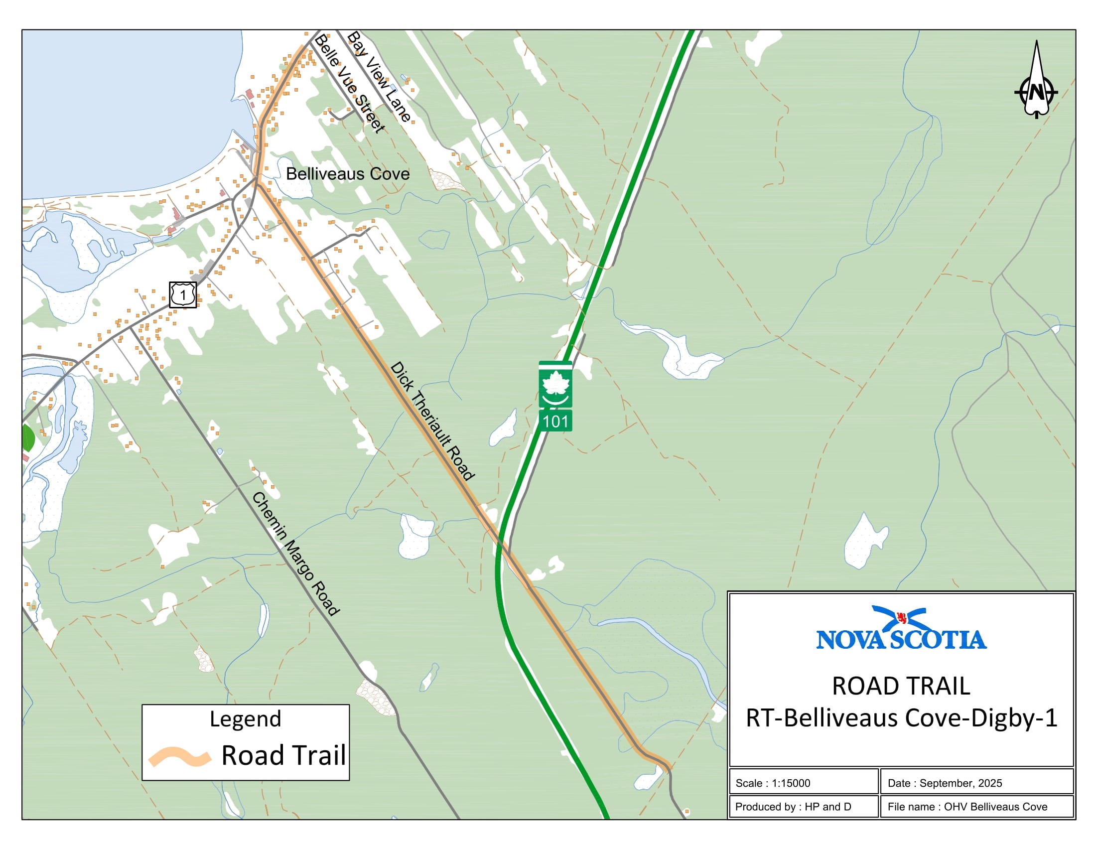
Appendix AV: Belliveaus Cove, Digby County
The road trail begins at coordinates 44.366717°N, 66.041038°W and travels northwest on Dick Theriault Road for 7.4 km. The road trail continues on Trunk 1 for a distance of 0.53 km to civic 3334, Trunk 1 in Belliveaus Cove.
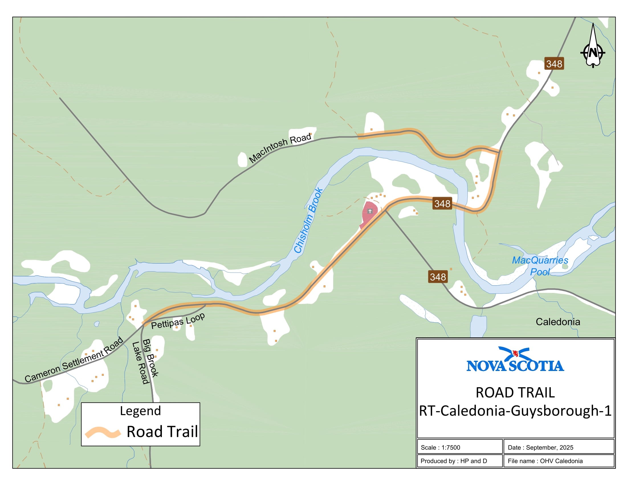
Appendix AW: Caledonia, Guysborough County
The road trail begins at coordinates 45.278135°N, 62.407029°W and travels northeast for 0.98 km. The road trail continues on Route 348 for a distance of 0.51 km and travels on MacIntosh Road in [a] westerly direction for a distance of 0.60 km in Caledonia.
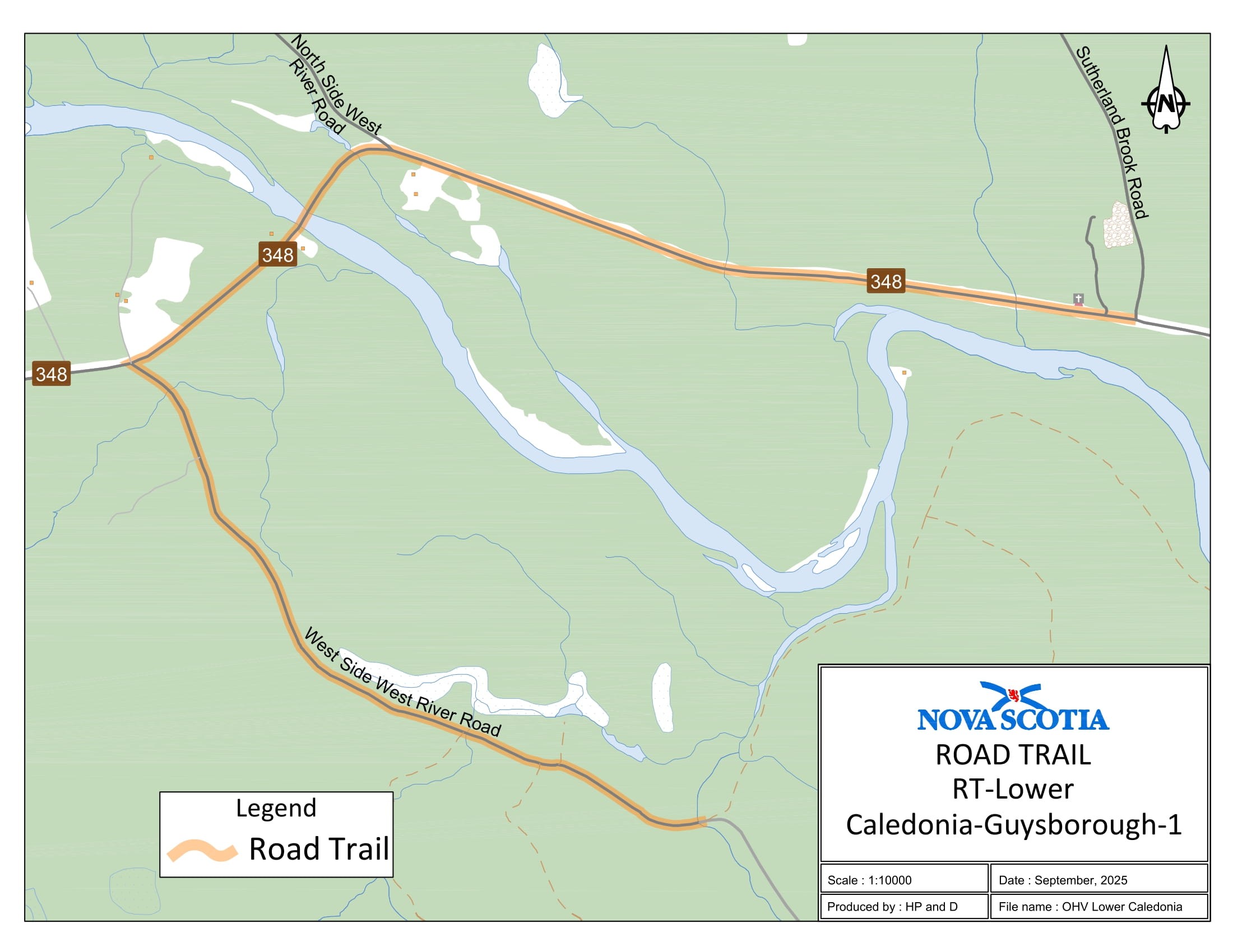
Appendix AX: Lower Caledonia, Guysborough County
The road trail begins at coordinates 45.261655°N, 62.262219°W and travels on West Side River Road for 1.79 km until it connects with Route 348 and continues in an easterly direction on Route 348 for a distance of 2.52 km until it reaches Sutherland Brook Road.
Appendix AY: North East Margaree, Inverness County
The road trail begins at coordinates 46.336838°N, 60.952247°W and travels north on Egypt Road for 2.7 km. The road trail continues on East Big Intervale Road for a distance of 0.2 km until it intersects with Fielding Road and continues in an easterly direction for a distance of 1.9 km.

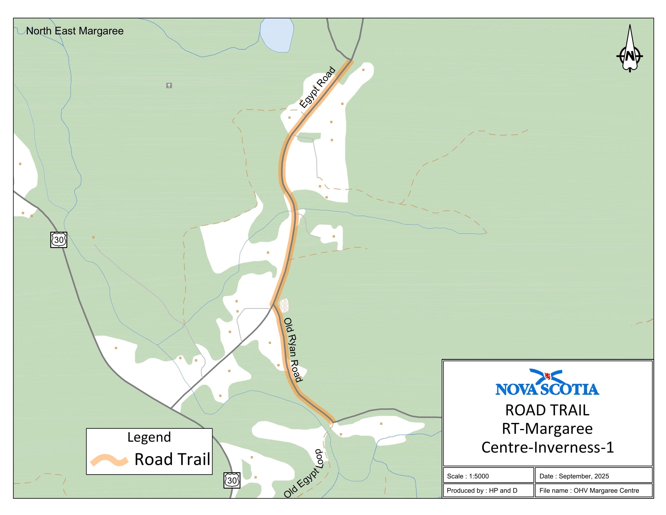
Appendix AZ: Margaree Centre, Inverness County
The road trail begins at coordinates 46.321066°N, 60.968314°W and travels south on Egypt Road for 0.58 km. The road trail continues on Old Ryan Road for 0.3 km until it intersects with Old Egypt Loop at coordinates 46.314103°N, 60.968843°W.
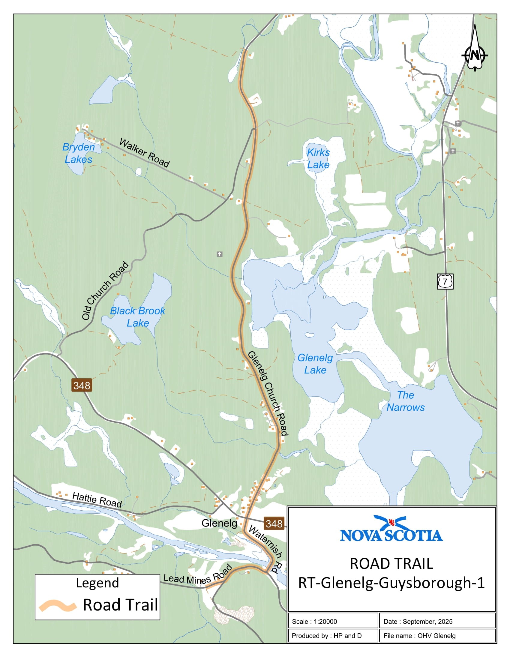
Appendix BA: Glenelg, Guysborough County
The road trail begins at coordinates 45.254805°N, 62.080790°W and travels in an easterly direction on Lead Mines Road for 0.42 km. The road trail continues on Waternish Road in a northernly direction for a distance of 0.57 km. The road trail continues on Glenelg Church Road for a distance of 4.71 km and concludes at coordinates 45.295386°N, 62.076809°W.
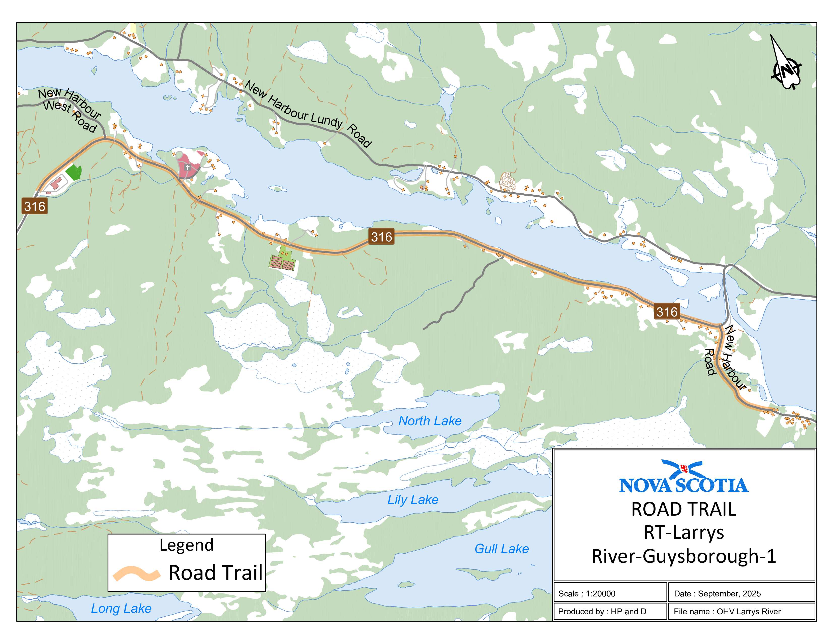
Appendix BB: Larrys River, Guysborough County
The road trail begins at coordinates 45.203012°N, 61.510122°W and travels in an easterly direction on Route 316 for 5.07 km. The road trail continues on New Harbour Road for an additional 0.75 km.
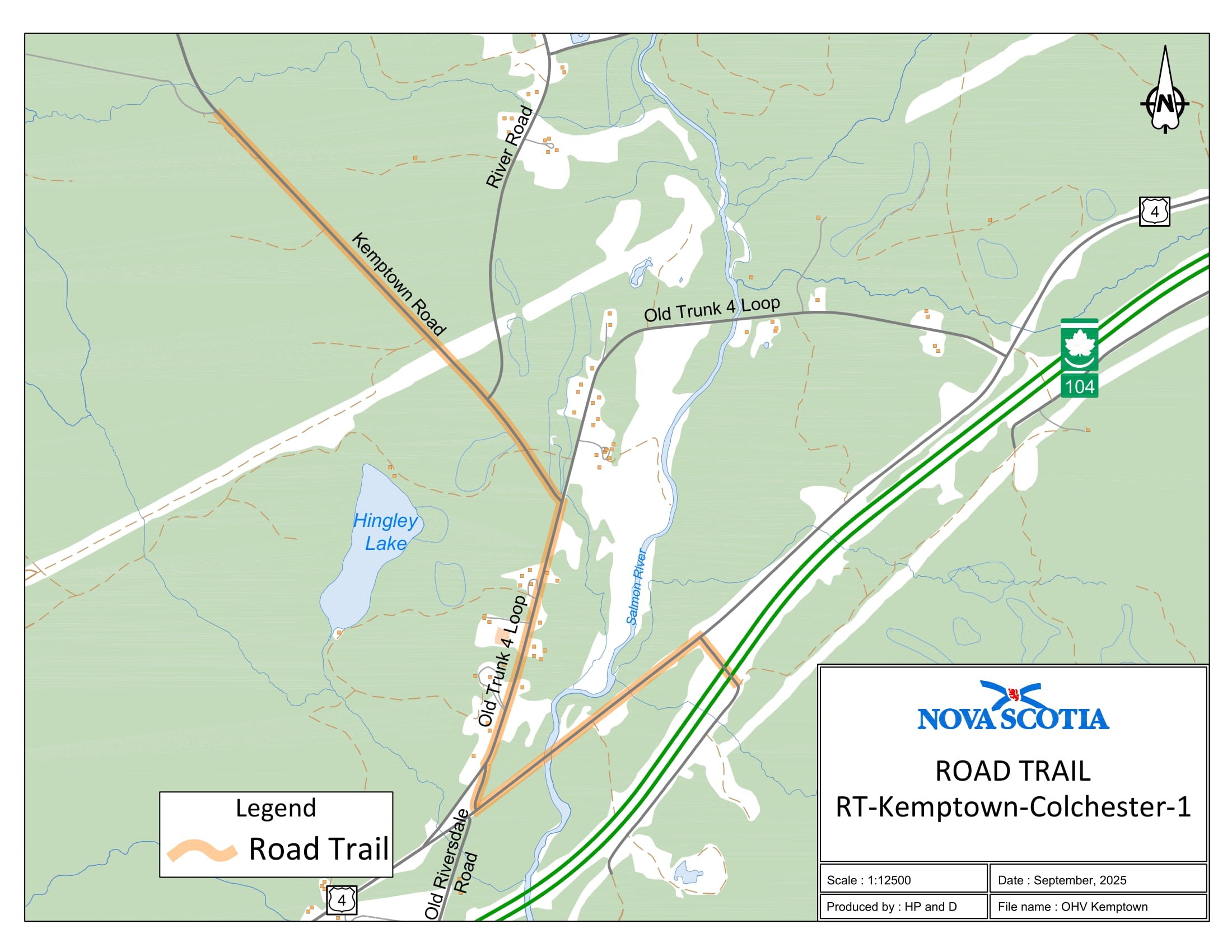
Appendix BC: Kemptown, Colchester County
The road trail begins at coordinates 45.479165°N, 63.085941°W and travels southeast on Kemptown Road for 1.47 km. The road trail continues on Loop Old Highway 4 Loop for 0.77 km. The road trail continues on Old Riversdale Road for 0.14 km. The road trail continues northeast on Pictou Road for 0.8 km. The road trail goes eastward on Service Road COL 104-12 for 0.18 km until coordinates 45.464337°N, 63.067241°W.
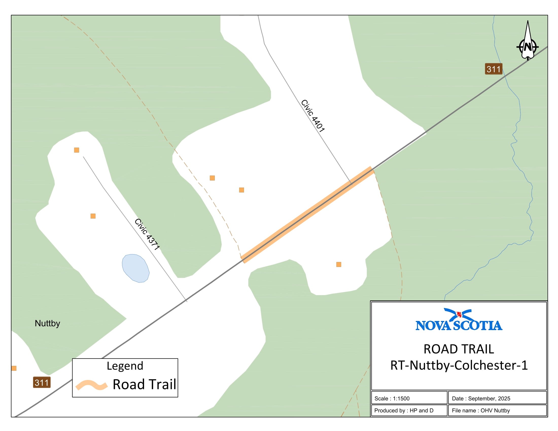
Appendix BD: Nuttby, Colchester County
The road trail begins at coordinates 45.536785°N, 63.172773°W and travels in a westerly direction on Route 311 for 0.11 km and concludes at coordinates 45.536329°N, 63.174052°W.
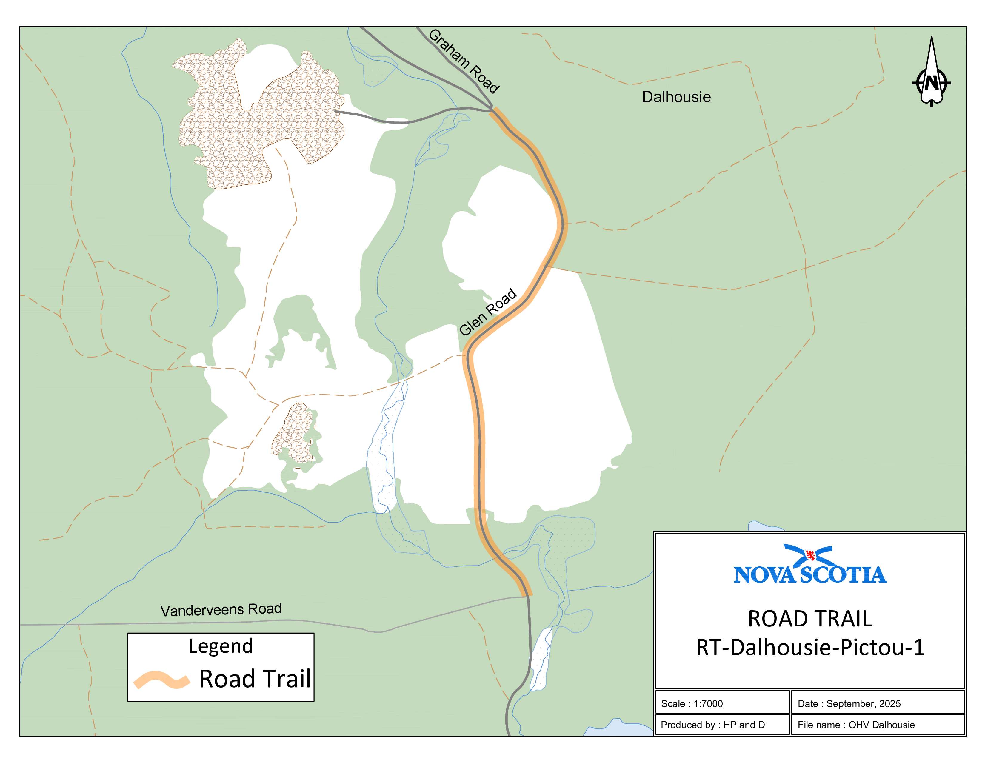
Appendix BE: Dalhousie, Pictou County
The road trail begins at coordinates 45.561385°N, 63.004528°W and travels south on Glen Road for 1.32 km and concludes at coordinates 45.550906°N, 63.004419°W.
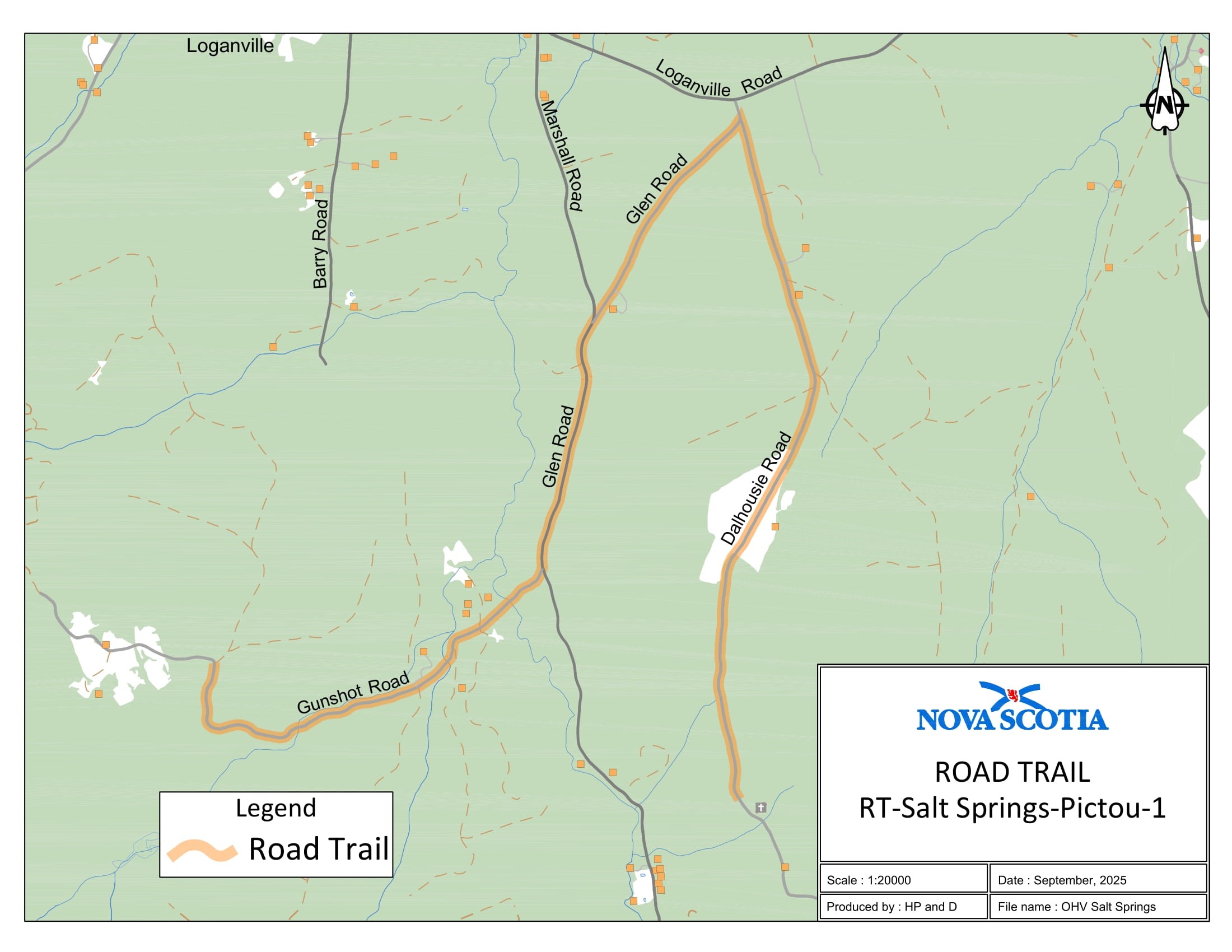
Appendix BF: Salt Springs, Pictou County
The road trail begins [at] coordinates 45.587856°N, 63.055367°W and travels south on Gunshot Road for 2.1 km. The road trail continues on Glen Road for a distance of 2.35 km in an easterly direction. The road trail continues on Dalhousie Road for a distance of 3.29 km and concludes at coordinates 45.582937°N, 63.024731°W.
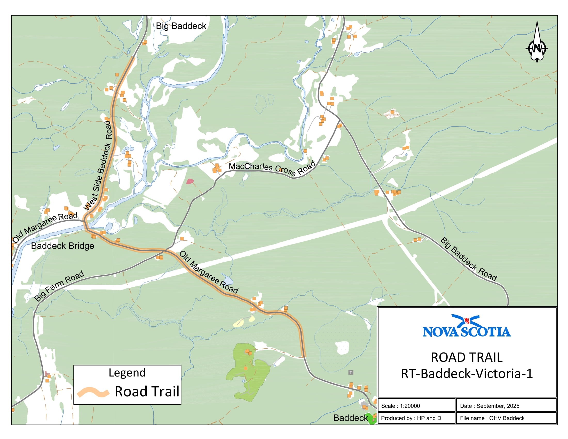
Appendix BG: Baddeck, Victoria County
The road trail begins at coordinates 46.111713°N, 60.775770°W and travels northwest for 2.73 km on Old Margaree Road. The road trail continues on West Side Baddeck Road and travels north for a distance of 1.73 km and concludes at coordinates 46.138434°N, 60.797180°W.
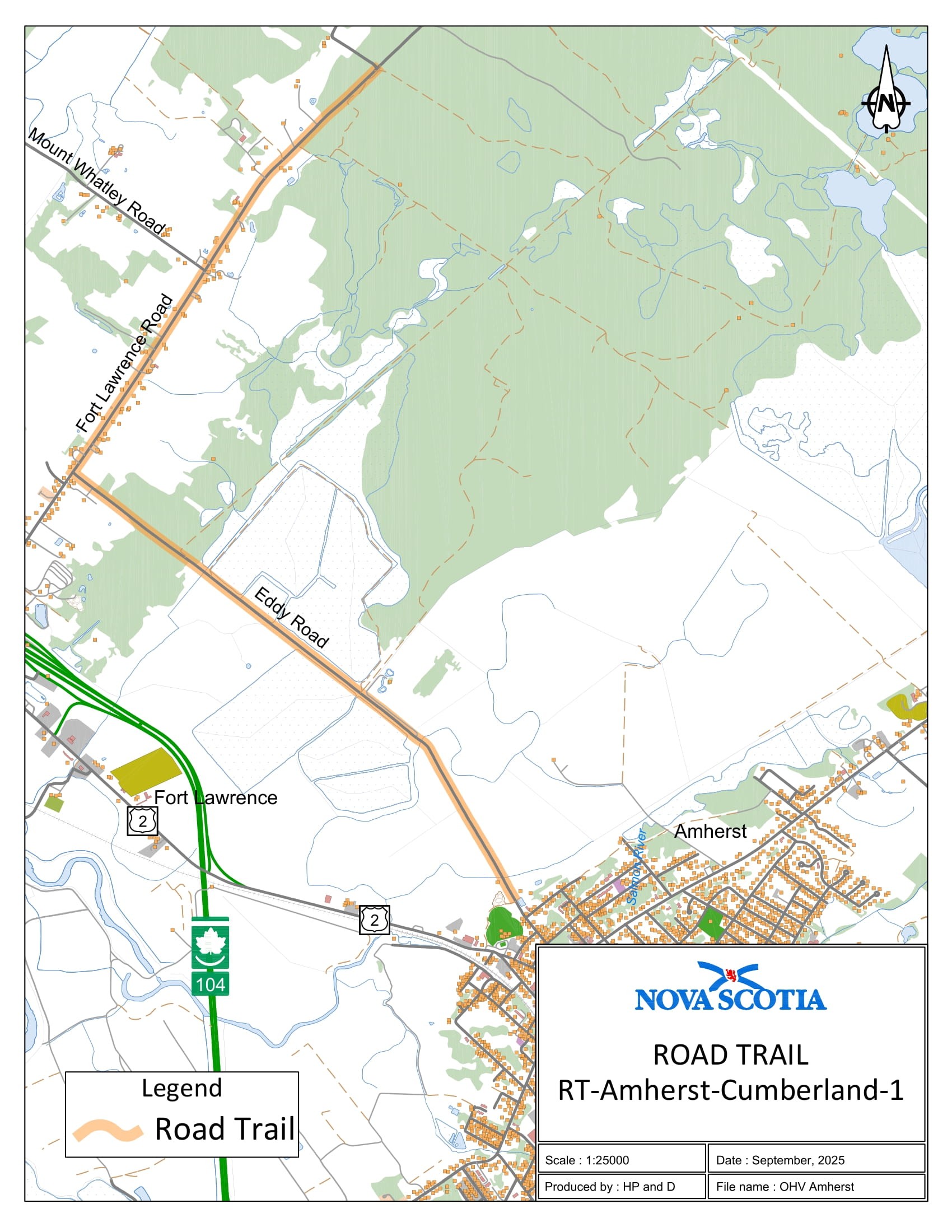
Appendix BH: Amherst, Cumberland County
The road trail begins at coordinates 45.881216°N, 64.226037°W and travels south on Fort Lawrence Road for 2.87 km. The road trail continues in an easterly direction on Eddy Road for a distance of 3.59 km.
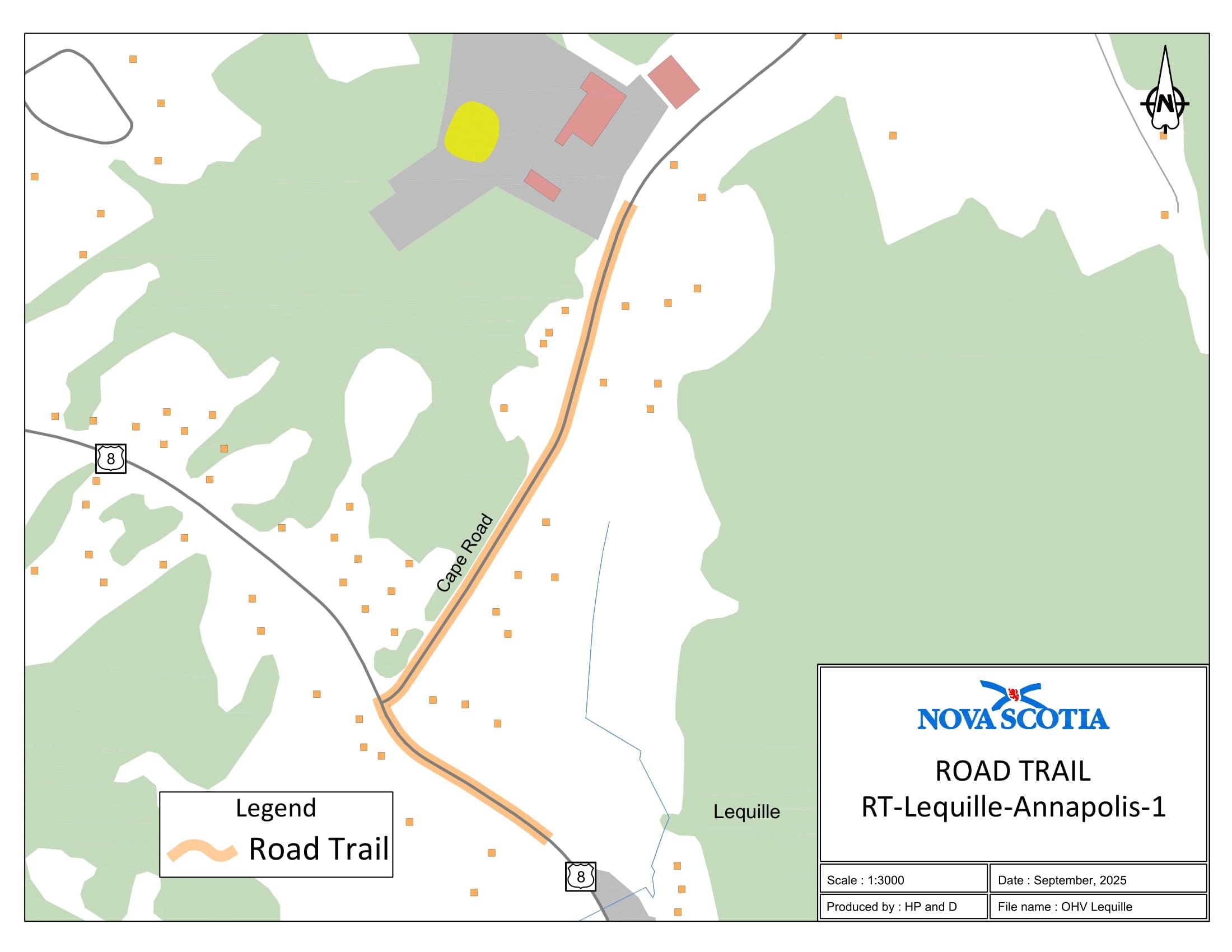
Appendix BI: Lequille, Annapolis County
The road trail begins at coordinates 44.735205°N, 65.491370°W and travels southeast on Cape Road for 0.39 km. The road trail continues in an easterly direction on Trunk 8 for a distance of 0.14 km and concludes at coordinates 44.731379°N, 65.492051°W.
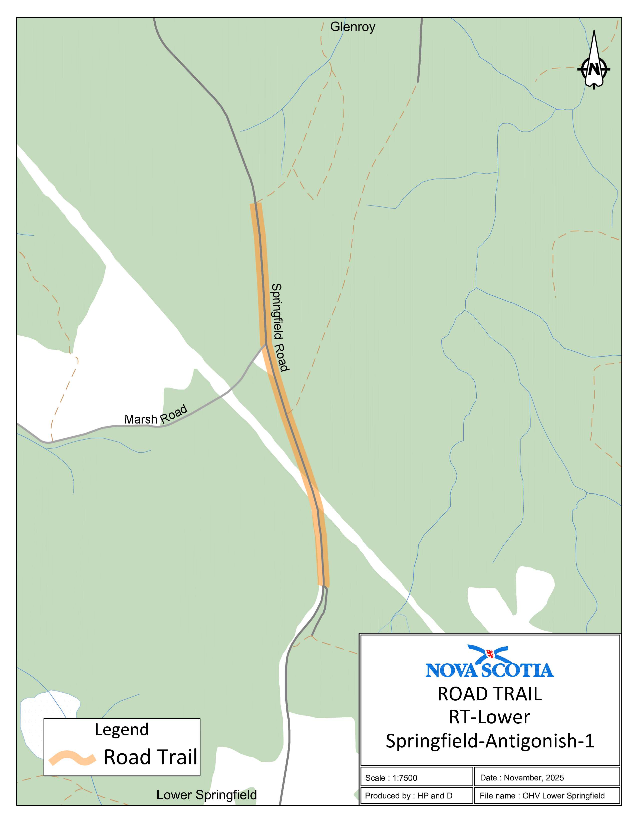
Appendix BJ: Lower Springfield, Antigonish County
The road trail begins at coordinates 45.452639°N, 61.865909°W and travels in a northeasterly direction on Upper Springfield Road for 0.28 km. The road trail continues north on Irish Road for 3.57 km and concludes at coordinates 45.481969°N, 61.872583°W.
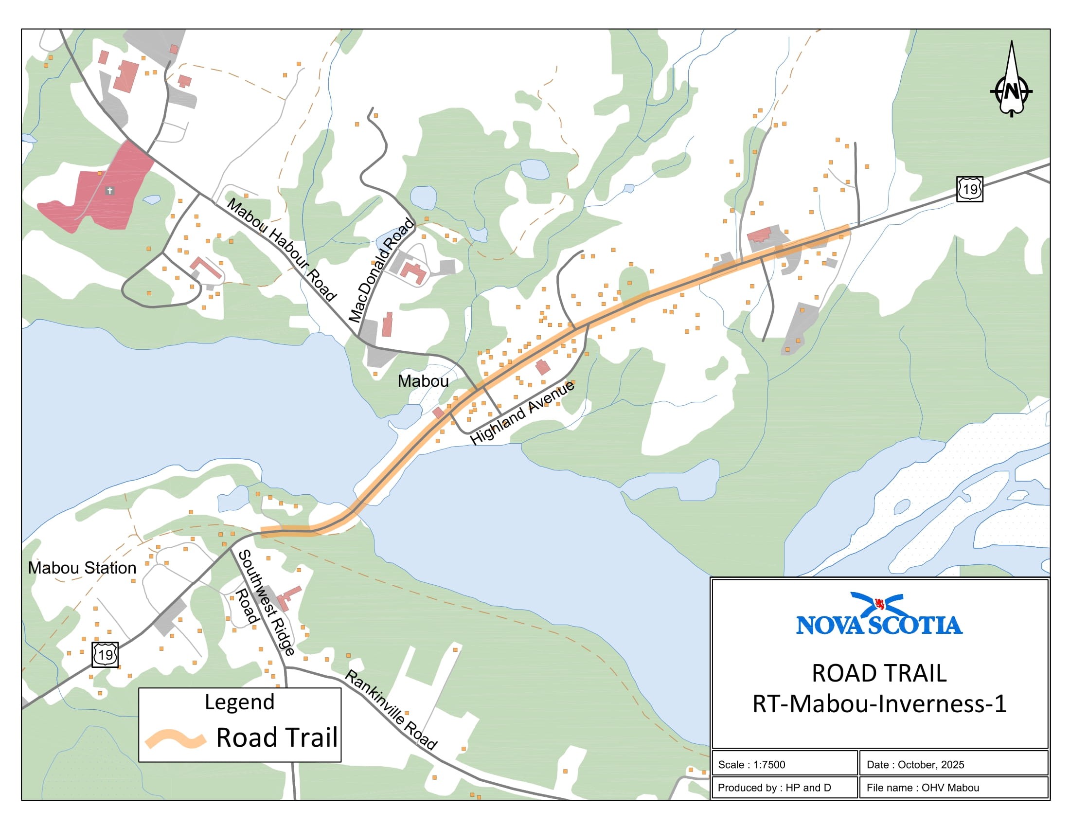
Appendix BK: Mabou, Inverness County
The road trail begins at coordinates 46.069355°N, 61.397646°W and travels north on Trunk 19 for 1.25 km.
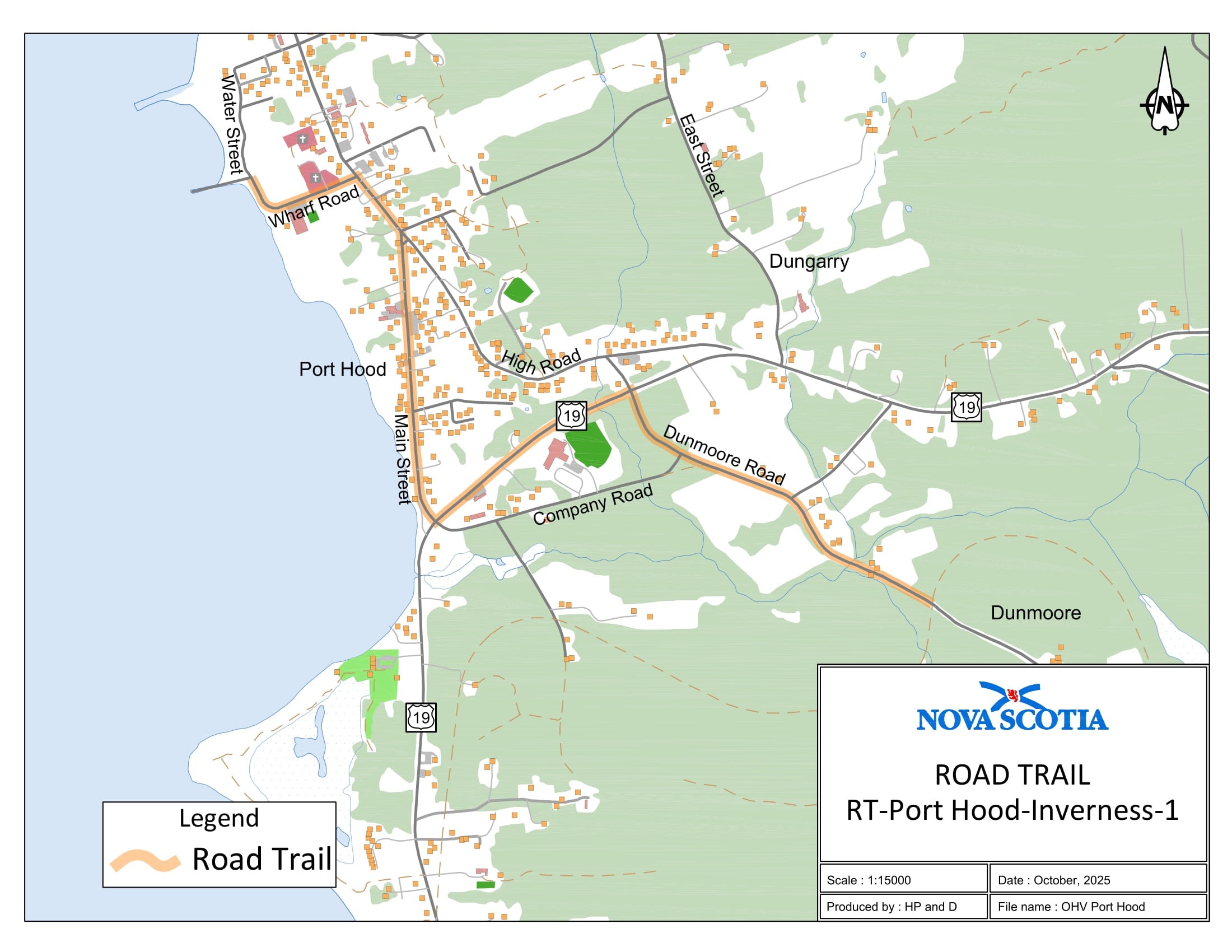
Appendix BL: Port Hood-1, Inverness County
The road trail begins at coordinates 46.004812°N, 61.507654°W and travels north on Dunmoore Road for 1.44 km. The road trail continues on Trunk 19 for a distance of 0.8 km in a westerly direction. The road trail continues on Main Street for a distance of 1.24 km in a northerly direction. The road trail continues on Wharf Road for a distance of 3.2 km in a westerly direction. The road trail continues north on Water Street for a distance of 0.11 km.
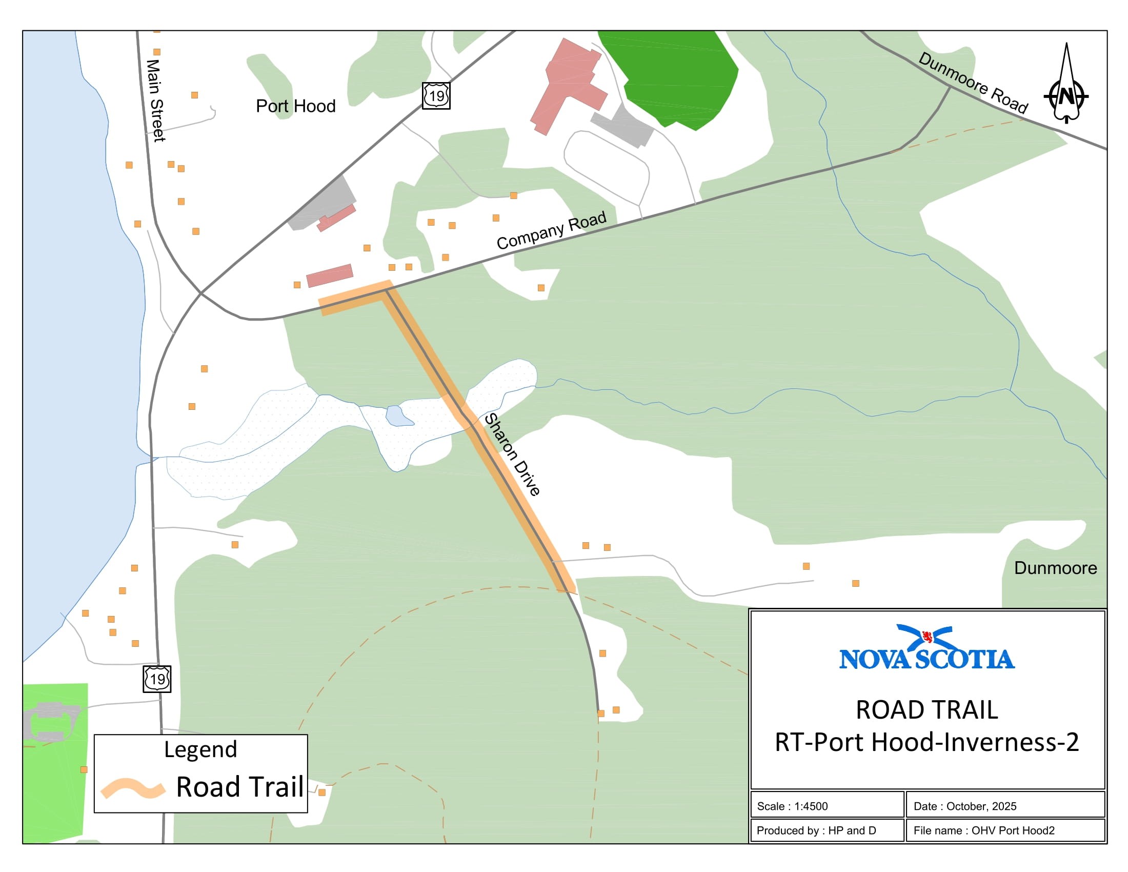
Appendix BM: Port Hood-2, Inverness County
The road trail begins at coordinates 46.004317°N, 61.524060°W and travels north on Sharon Road for 0.39 km. The road trail continues on Company Road for a distance of 0.08 km in a westerly direction.
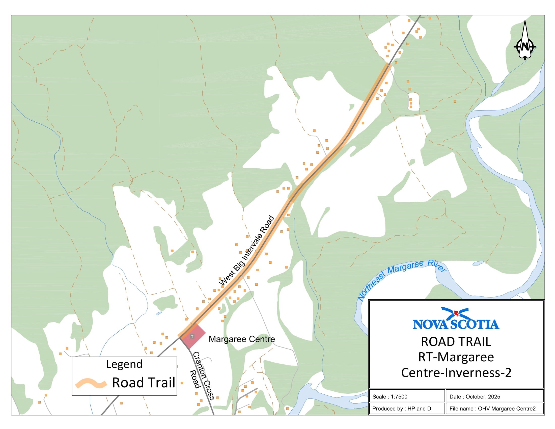
Appendix BN: West Big Intervale, Inverness County
The road trail begins at coordinates 46.347490°N, 60.999086°W and travels north on West Big Intervale Road for 1.3 km.
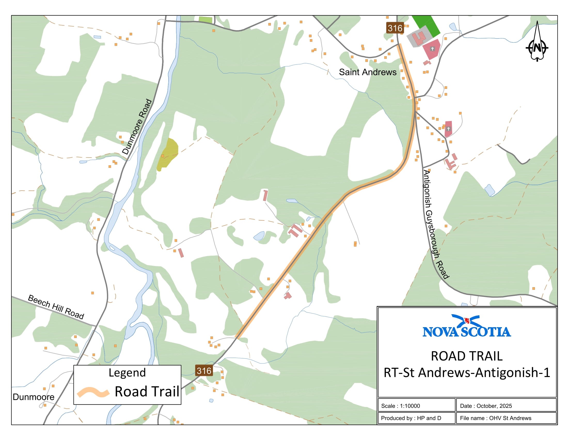
Appendix BO: St. Andrew’s, Antigonish County
The road trail begins at coordinates 45.545422°N, 61.900247°W and travels north on Route 316 for 1.84 km.
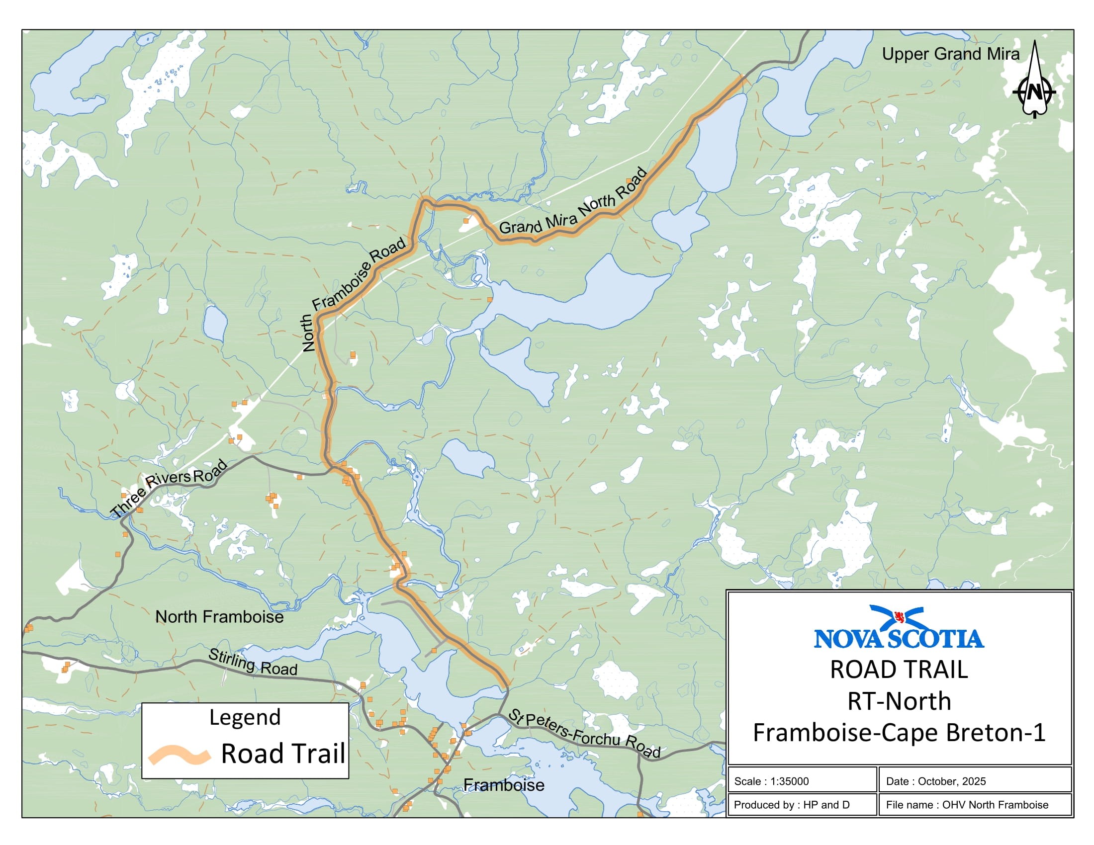
Appendix BP: North Framboise, Richmond County
The road trail begins at coordinates 45.726126°N, 60.355639°W and travels north for 5.56 km on North Framboise Road. The road trail continues on Grand Mira North Road and travels in a northeasterly direction for a distance of 3.62 km and concludes at coordinates 45.774832°N, 60.327318°W.
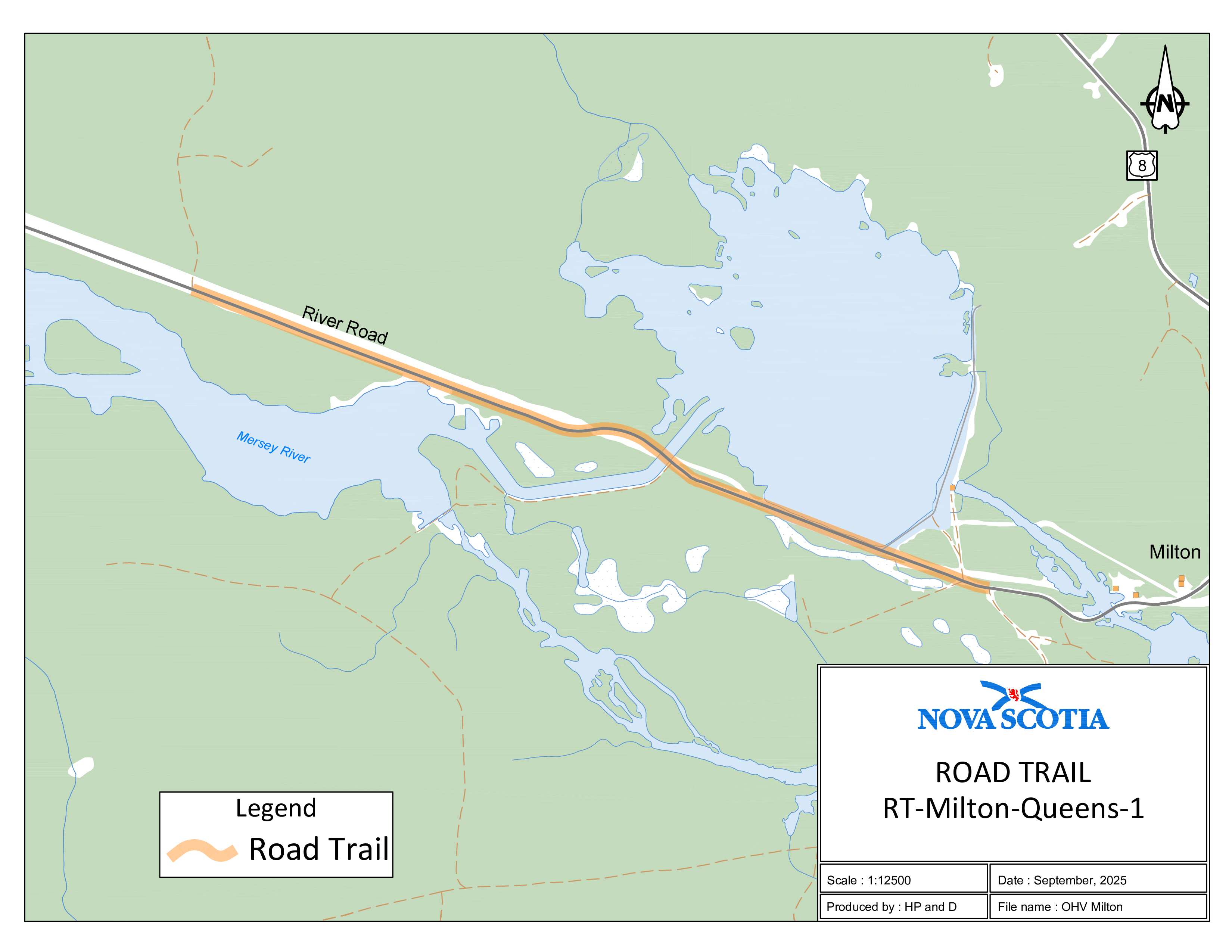
Appendix BQ: Milton, Queens County
The road trail begins at coordinates 44.085573°N, 64.817753°W and travels in an easterly direction on River Road for 1.47 km and concludes at coordinates 44.077966°N, 64.789381°W.
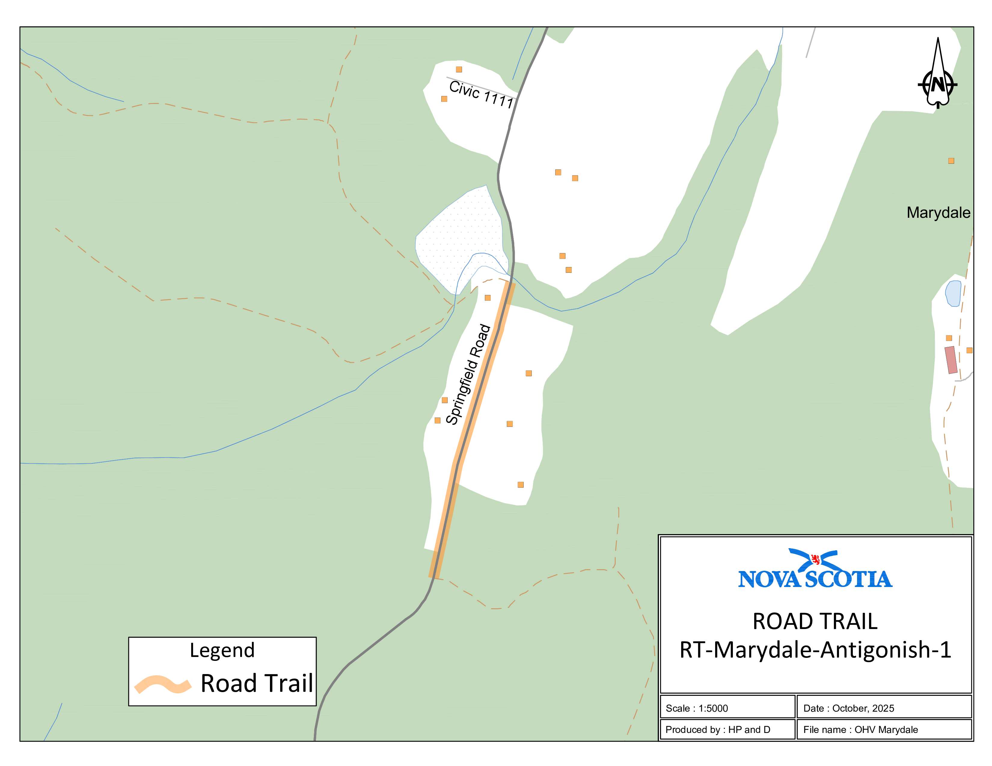
Appendix BR: Marydale, Antigonish County (Springfield Road)
The road trail begins at coordinates 45.529943°N, 61.882114°W and travels north on Springfield Road for 0.43 km and concludes at coordinates 45.533723°N, 61.880867°W.
Appendix BS: Springfield, Antigonish County
The road trail begins at coordinates 45.452639°N, 61.865909°W and travels in an easterly direction for 0.28 km on Upper Springfield Road. The road trail continues on Irish Road and travels north for a distance of 3.57 km and concludes at coordinates 45.481969°N, 61.872583°W.

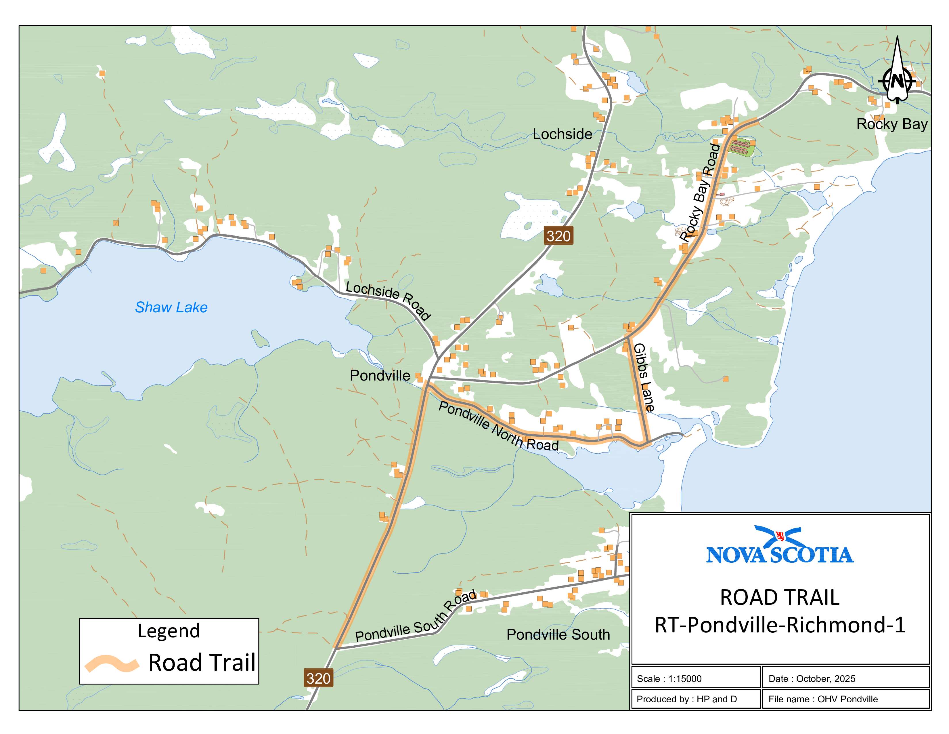
Appendix BT: Pondville, Richmond County
The road trail begins at coordinates 45.531511°N, 60.997064°W and travels north on Route 320 for 1.1 km. The road trail continues on Pondville North Road for a distance of 1.1 km in an easterly direction. The road trail continues on Gibbs Lane for a distance of 0.47 km in a northerly direction. The road trail continues on Rocky Bay Road for a distance of 1.2 km in a northerly direction and concludes at coordinates 45.551165°N, 60.973712°W.
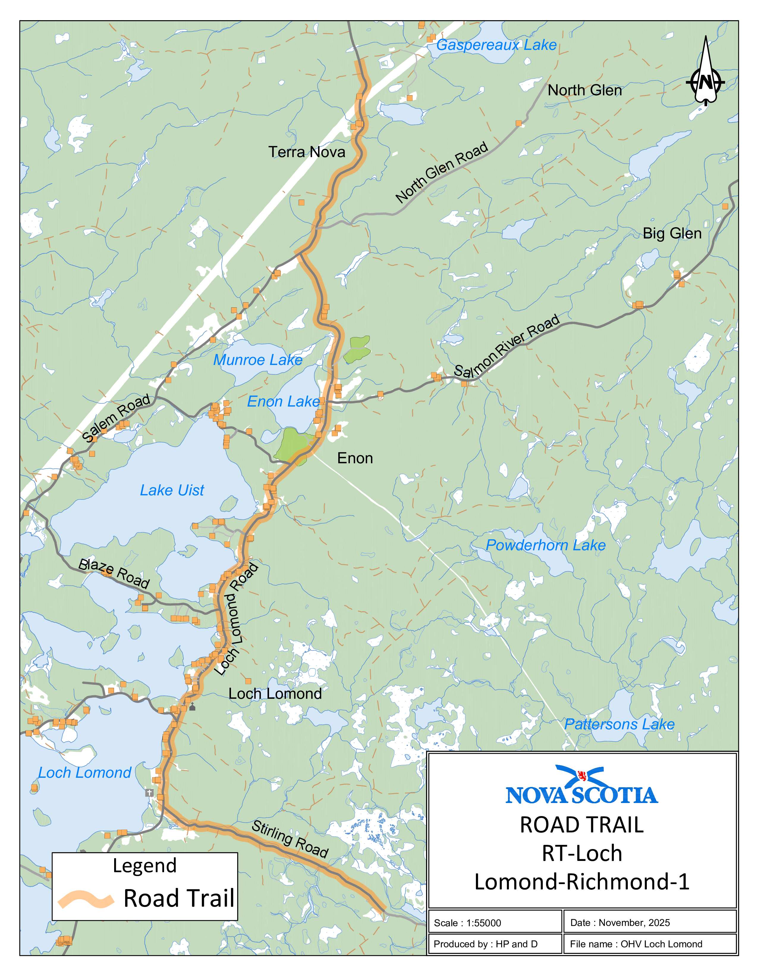
Appendix BU: Loch Lomond, Richmond County
The road trail begins at coordinates 45.737581°N, 60.518649°W and travels westerly on Stirling Road for 4.5 km. The road trail continues on Loch Lomond Road for a distance of 13.5 km in a northerly direction and concludes at coordinates 45.859486°N, 60.528117°W.
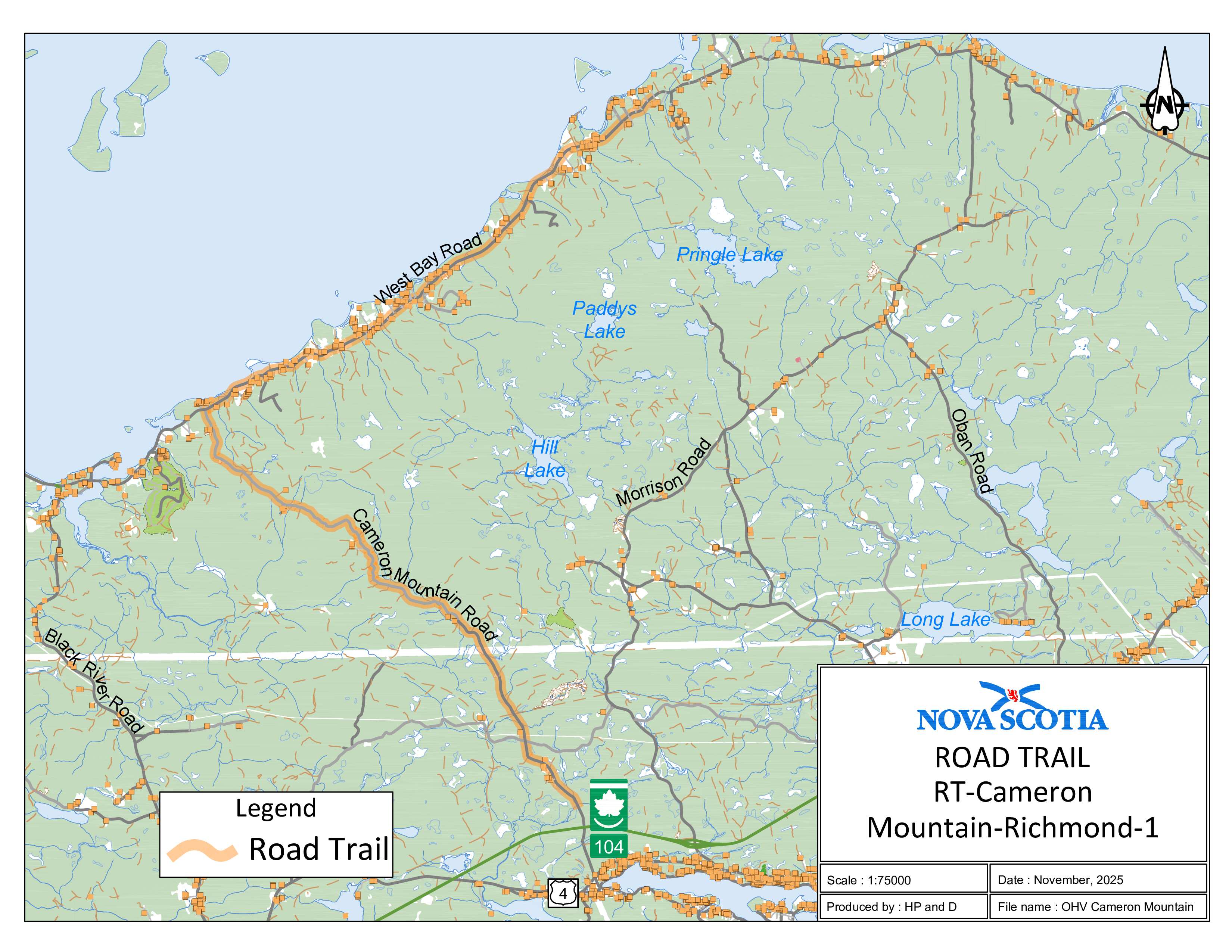
Appendix BV: Cameron Mountain, Richmond County
The road trail begins at coordinates 45.644772°N, 60.988476°W and travels north on Cameron Mountain Road for 10.5 km. The road trail continues on West Bay Road for a distance of 9.7 km in an easterly direction and concludes at coordinates 45.756316°N, 60.971915°W.