| This consolidation is unofficial and is for reference only. For the official version of the regulations, consult the original documents on file with the Office of the Registrar of Regulations, or refer to the Royal Gazette Part II. |
| Regulations are amended frequently. Please check the list of Regulations by Act to see if there are any recent amendments to these regulations filed with our office that are not yet included in this consolidation. |
| Although every effort has been made to ensure the accuracy of this electronic version, the Office of the Registrar of Regulations assumes no responsibility for any discrepancies that may have resulted from reformatting. |
| This electronic version is copyright © , Province of Nova Scotia, all rights reserved. It is for your personal use and may not be copied for the purposes of resale in this or any other form. |
Road Trails Designation: Appendices Z - AU
Table of Contents
Please note: this table of contents is provided for convenience of reference and does not form part of the regulations.
Click here to return to the index of all road trails designations.
Appendix Z: St. Peter’s, Richmond County
Appendix AA: Thibeauville, Richmond County
Appendix AB: Balmoral, Richmond County
Appendix AC: Cleveland, Richmond County
Appendix AD: Bridgetown, Annapolis County
Appendix AE: Conway, Digby County
Appendix AF: Lequille, Annapolis County
Appendix AG: Nictaux, Annapolis County
Appendix AH: Port Hilford, Guysborough County
Appendix AI: Sherbrooke, Guysborough County
Appendix AJ: Devon, Halifax Regional Municipality
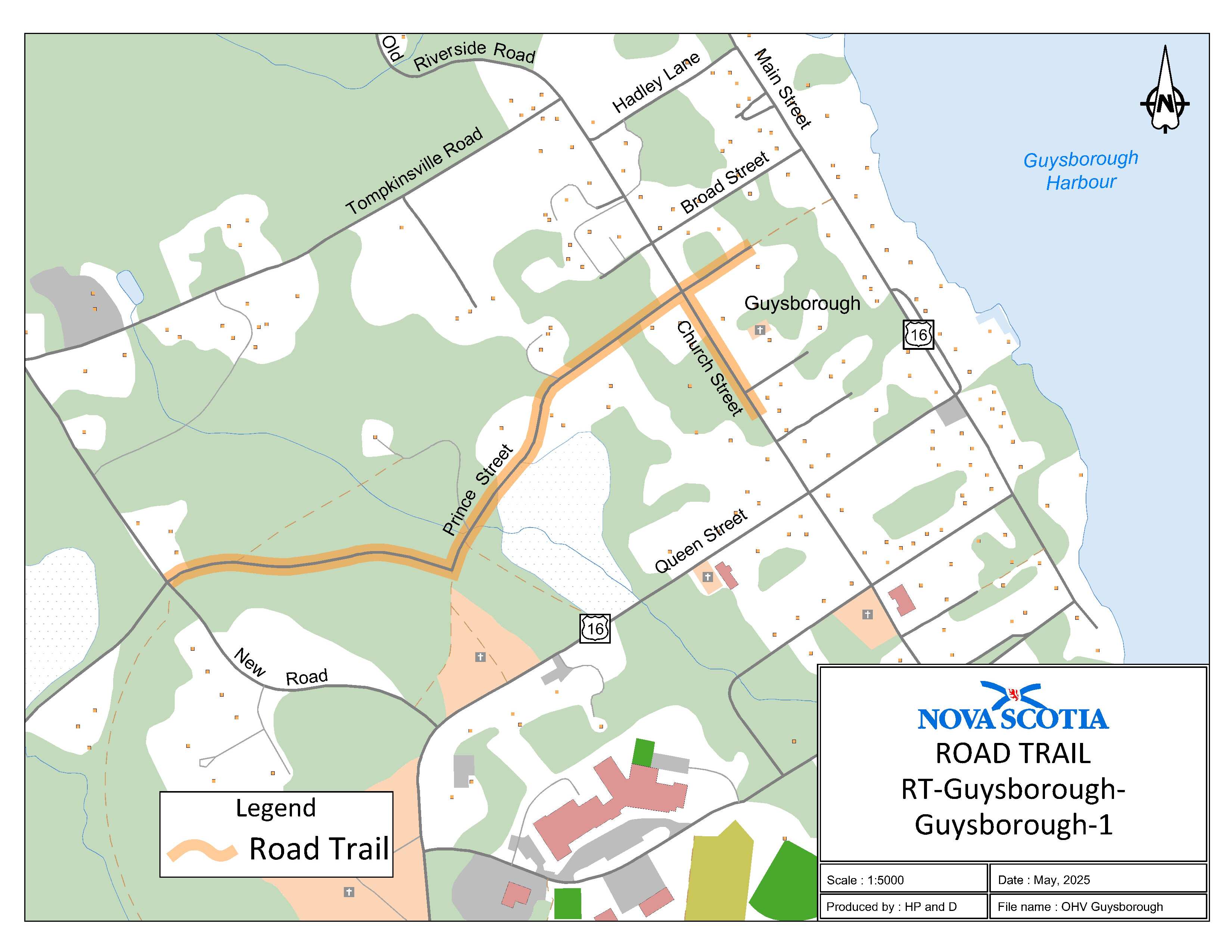
Appendix AK: Guysborough, Guysborough County
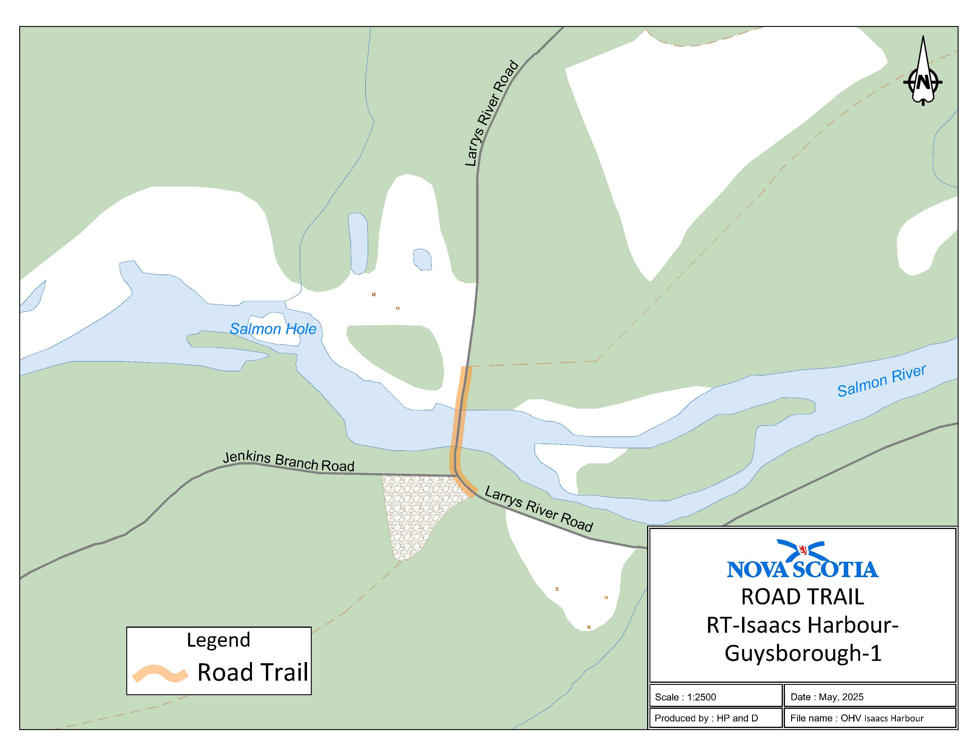
Appendix AL: Isaacs Harbour, Guysborough County
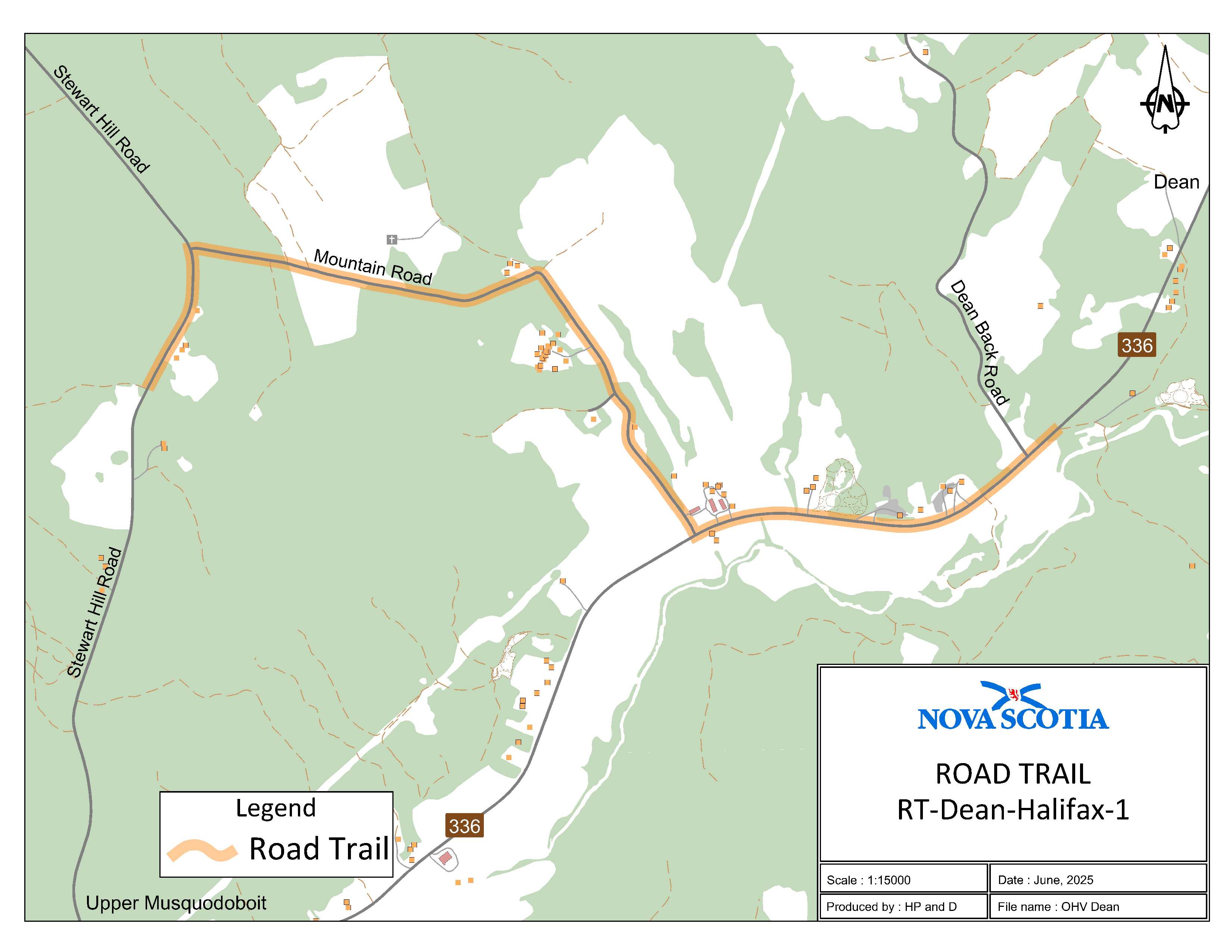
Appendix AM: Dean, Halifax Regional Municipality
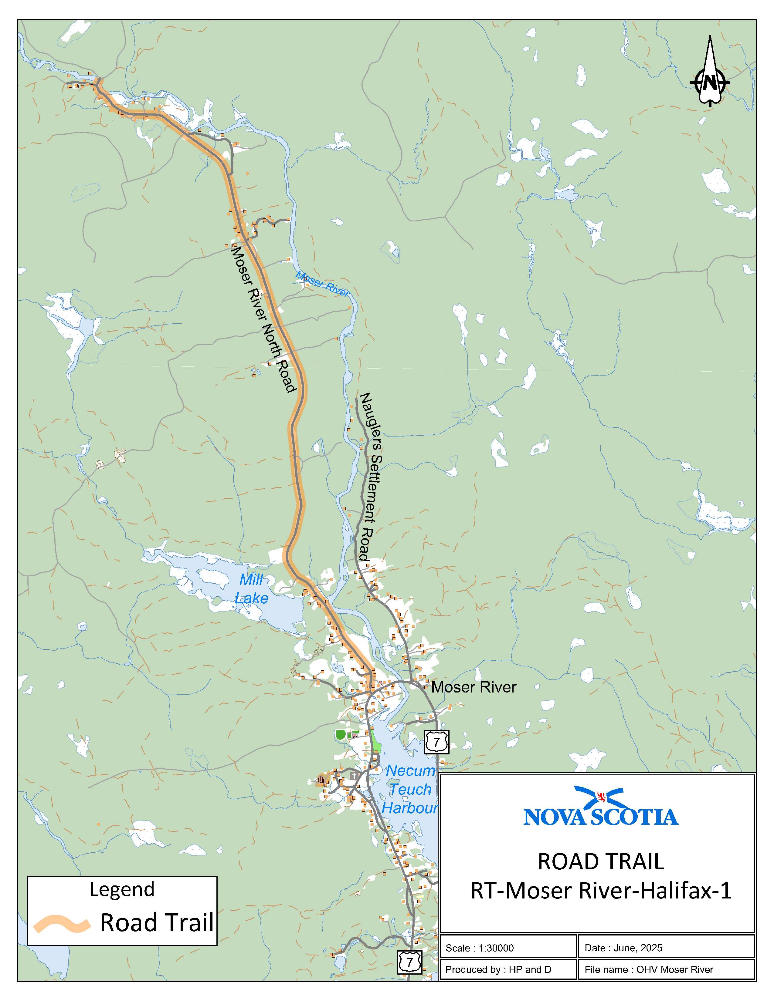
Appendix AN: Moser River, Halifax Regional Municipality
Appendix AO: Marshy Hope, Pictou County
Appendix AP: Thorburn, Pictou County (Thorburn Road)
Appendix AQ: Pugwash, Cumberland County
Appendix AR: Maccan, Cumberland County
Appendix AS: Birchtown, Shelburne County
Appendix AT: Mira Gut, Cape Breton Regional Municipality
Appendix AU: Wallace, Cumberland County
Coordinates are decimal degrees map coordinates taken from Google Earth.
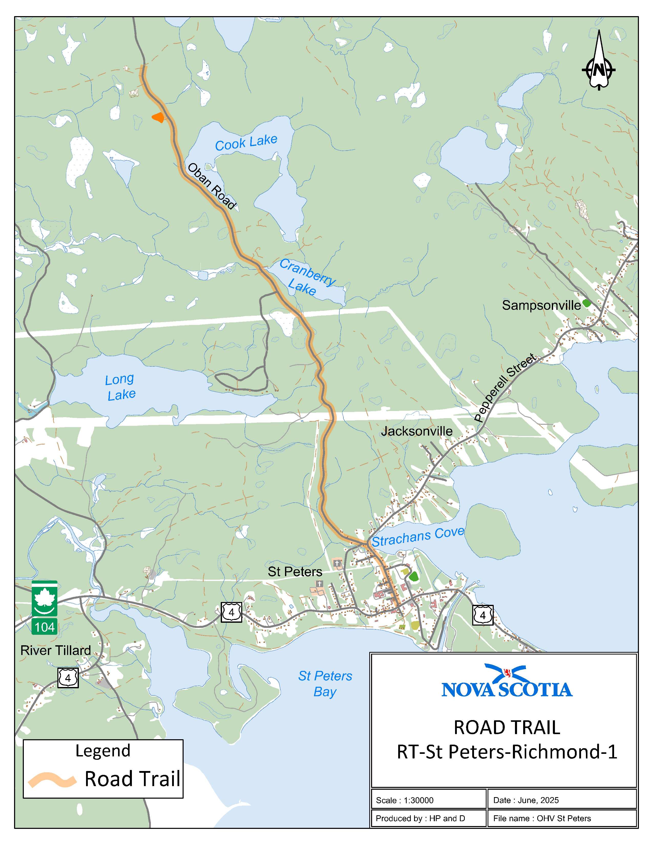
Appendix Z: St. Peter’s, Richmond County
The road trail begins 0.9 km south of civic 297 Oban Road on a forestry road on the Department of Natural Resources property at coordinates 45.704490°N, 60.906975°W and goes south for 5.75 km. The road trail continues on Pepperell Street for 0.70 km to the intersection of Pepperell Street and Granville Street in St. Peter’s.
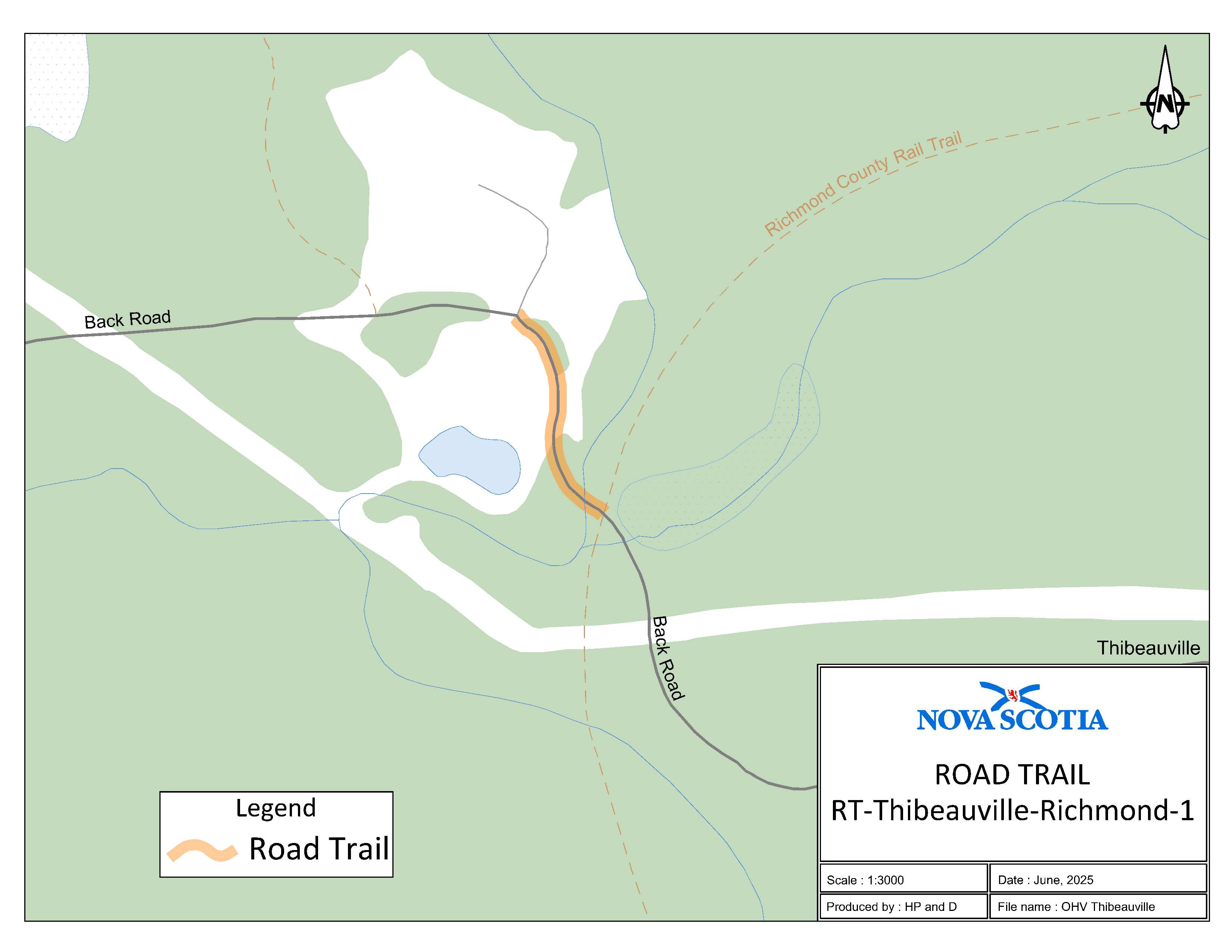
Appendix AA: Thibeauville, Richmond County
The road trail begins adjacent to 1520 Back Road at coordinates 45.660440°N, 61.010230°W and goes southeast on Black Road for 0.16 km.
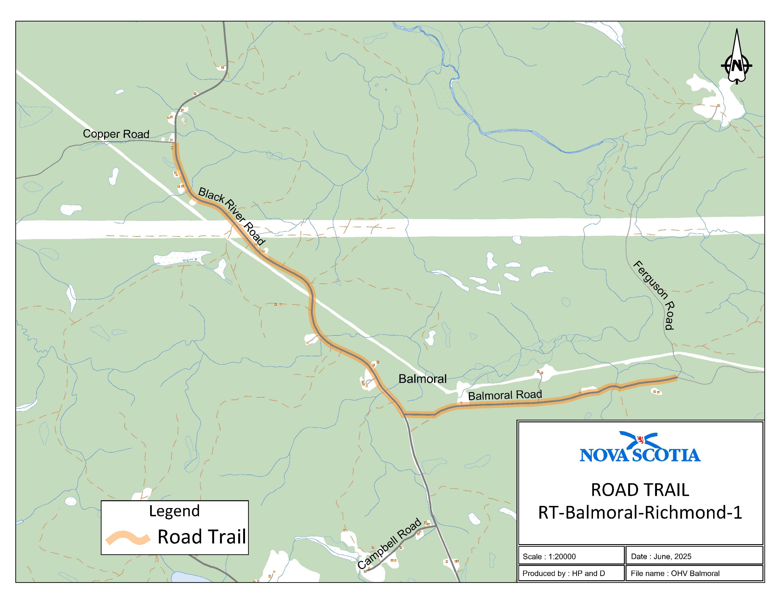
Appendix AB: Balmoral, Richmond County
The road trail begins at the intersection of Cooper Road and Black River Road at coordinates 45.676463°N, 61.107757°W and goes southeast on Black River Road for 2.7 km. The road trail continues east on Balmoral Road for 2 km where Balmoral Road intersects with the K-class road at coordinates 45.661217°N, 61.061682°W.
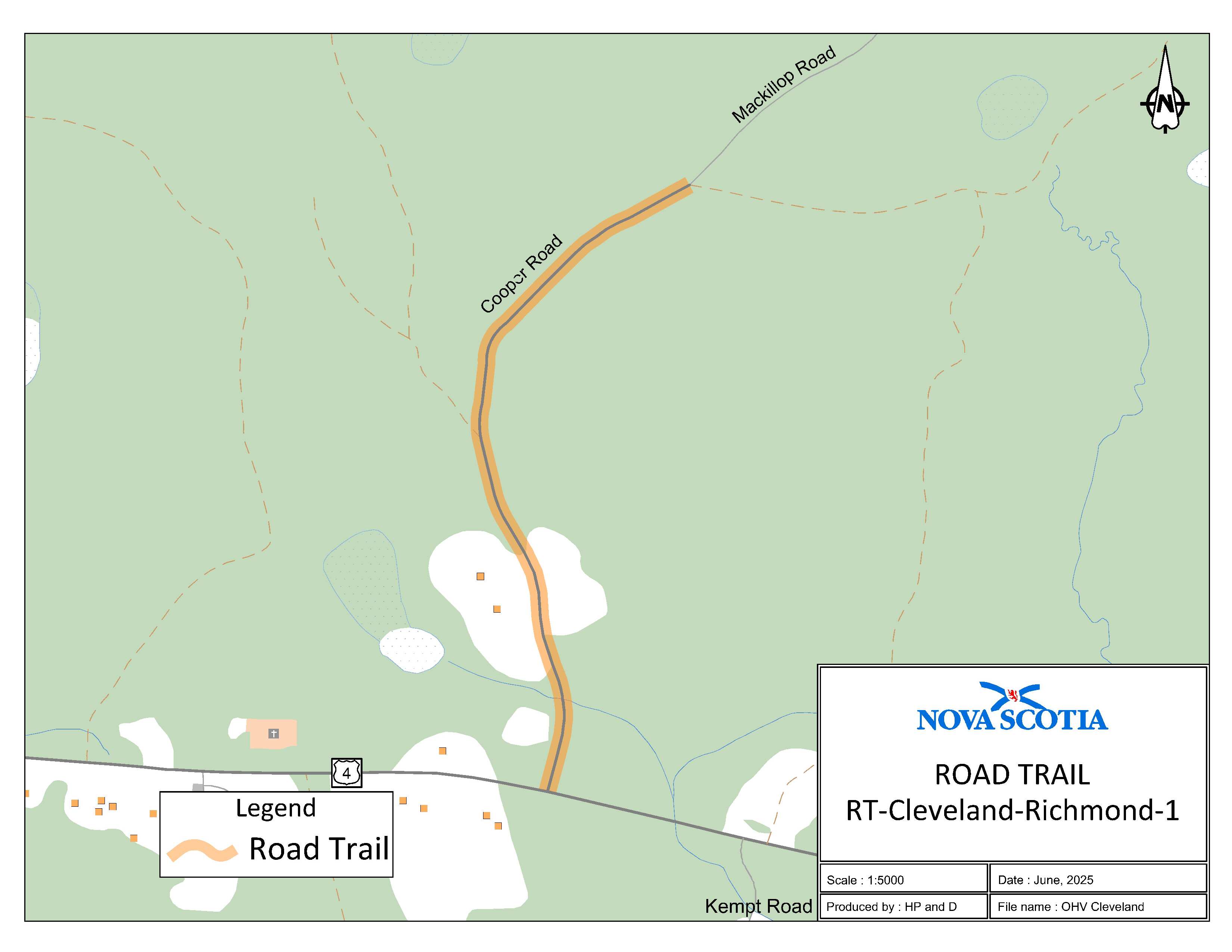
Appendix AC: Cleveland, Richmond County
The road trail begins where the I-class section of Coopers Road intersects the K-class section of Coopers Road at coordinates 45.664273°N, 61.171958°W and continues south on Cooper Road for 0.82 km to the intersection of Cooper Road and Trunk 4.
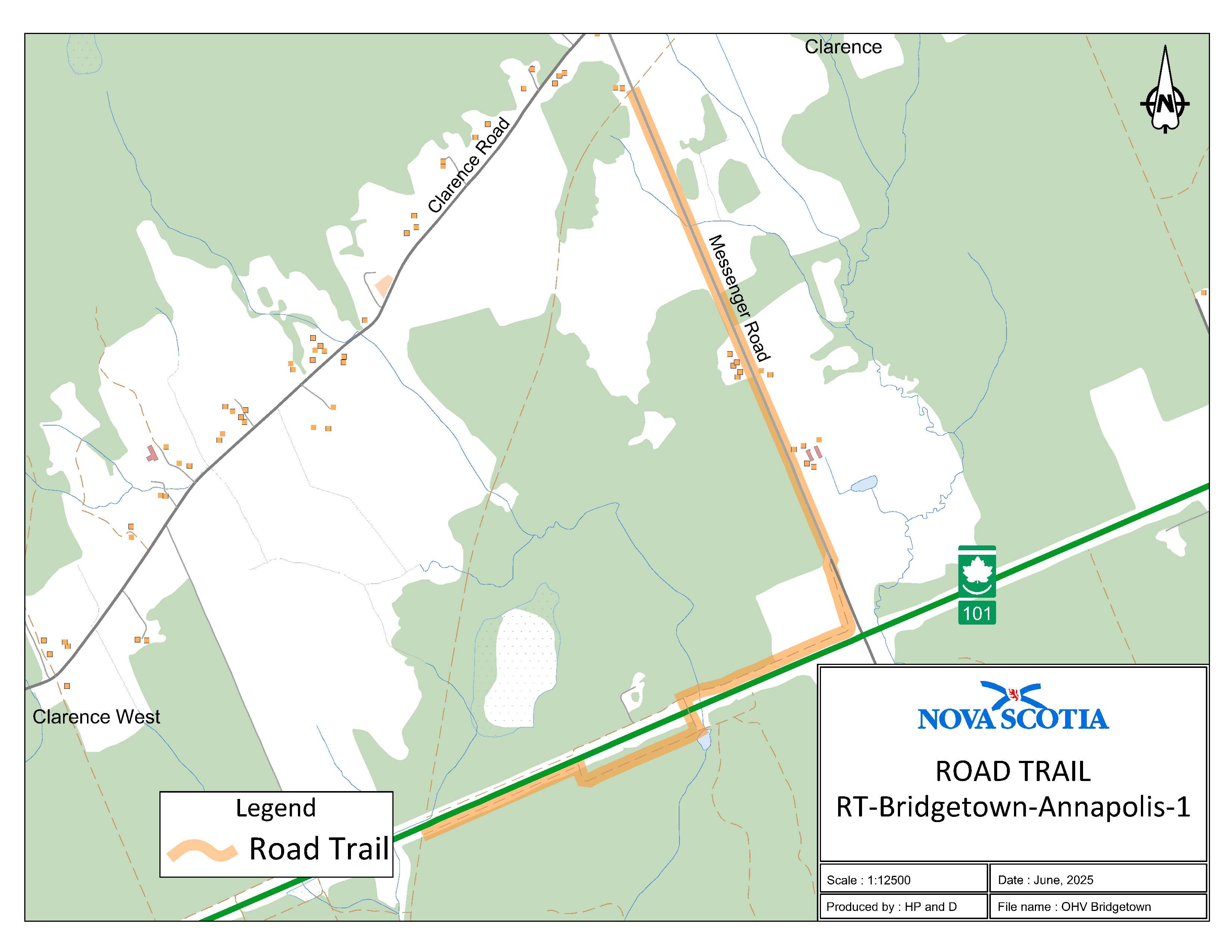
Appendix AD: Bridgetown, Annapolis County
The road trail begins adjacent to civic 478 Messenger Road at coordinates 44.887546°N, 65.253985°W and goes southeast for 4.15 km. The road trail continues south on the service road adjacent to Highway 101 for 0.75 km and then goes under Highway 101 via a large culvert in a southeast direction and then continues south on another service road adjacent to Highway 101 for 0.87 km where it meets the OHV trail at coordinates 44.848839°N, 65.266682°W.
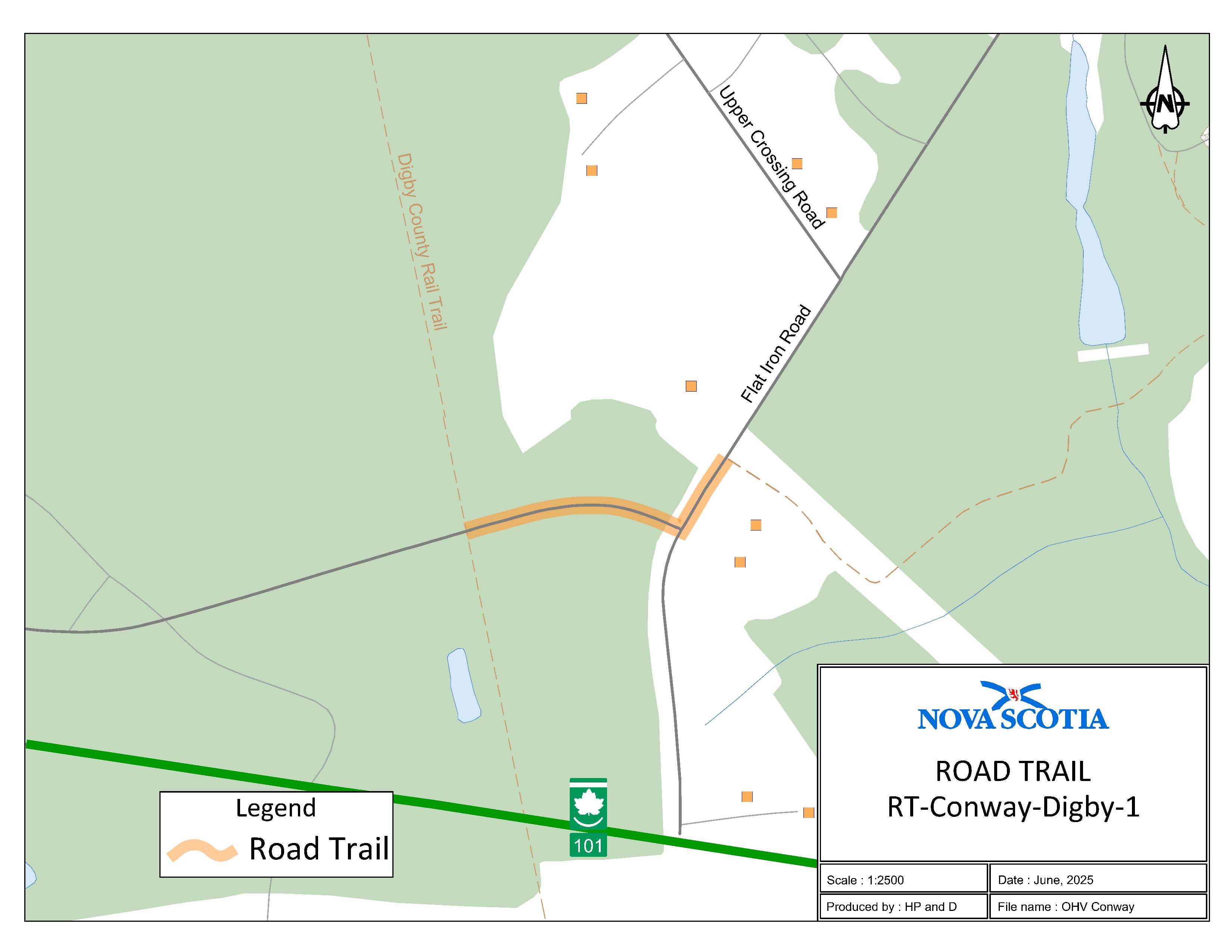
Appendix AE: Conway, Digby County
The road trail begins at the intersection of Rail Trail and Service Road at coordinates 44.599444°N, 65.779803°W and goes east for 0.12 km. The road trail continues on Flat Iron Road to a trailhead adjacent to 48 Flat Iron Road at coordinates 44.599821°N, 65.777928°W.
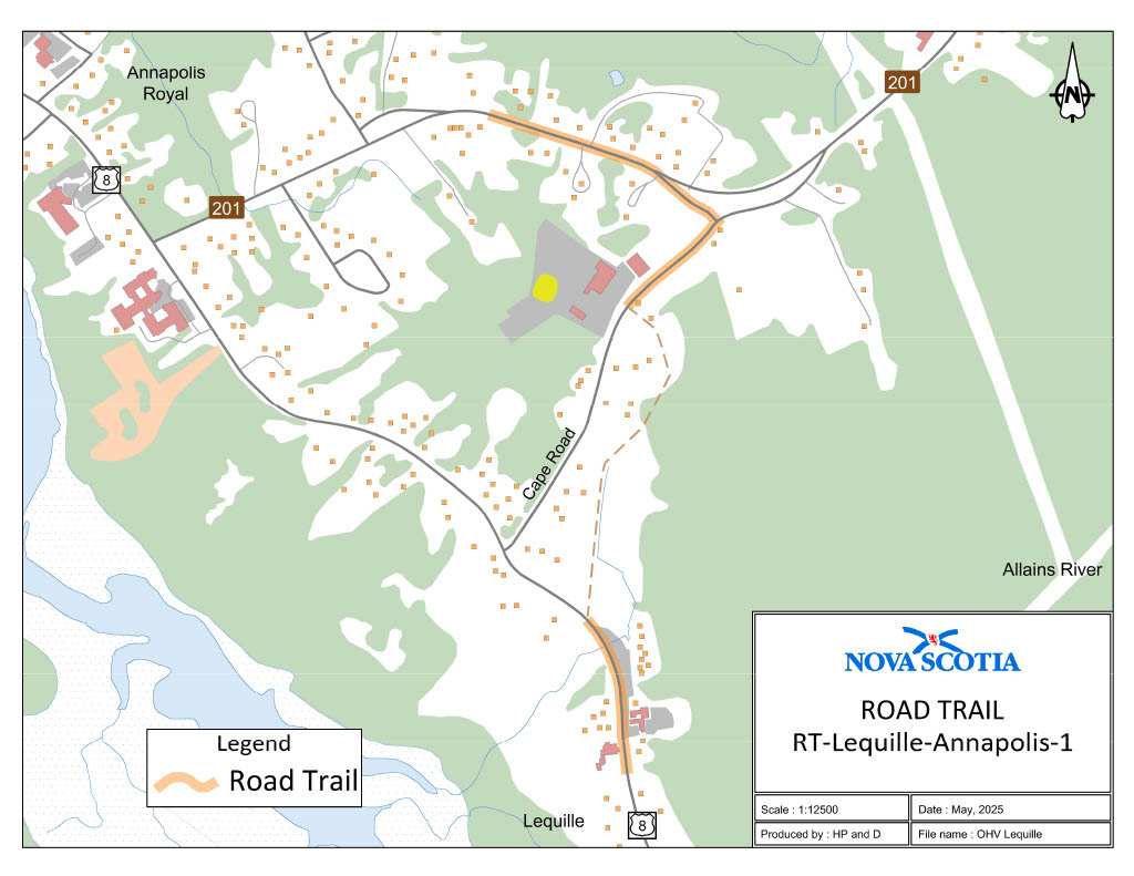
Appendix AF: Lequille, Annapolis County
Part 1:
The road trail begins adjacent to civic 117 on Route 201 at coordinates 44.737966, 65.493715°W and goes east for 0.22 km. The road trail continues south on Cape Road for 0.29 km which ends at coordinates 44.733989°N, 65.491509°W.
Part 2:
The road trail continues southeast on Trunk 8 from adjacent to civic 9589 at coordinates 44.731375°N, 65.492050°W for 0.25 km.
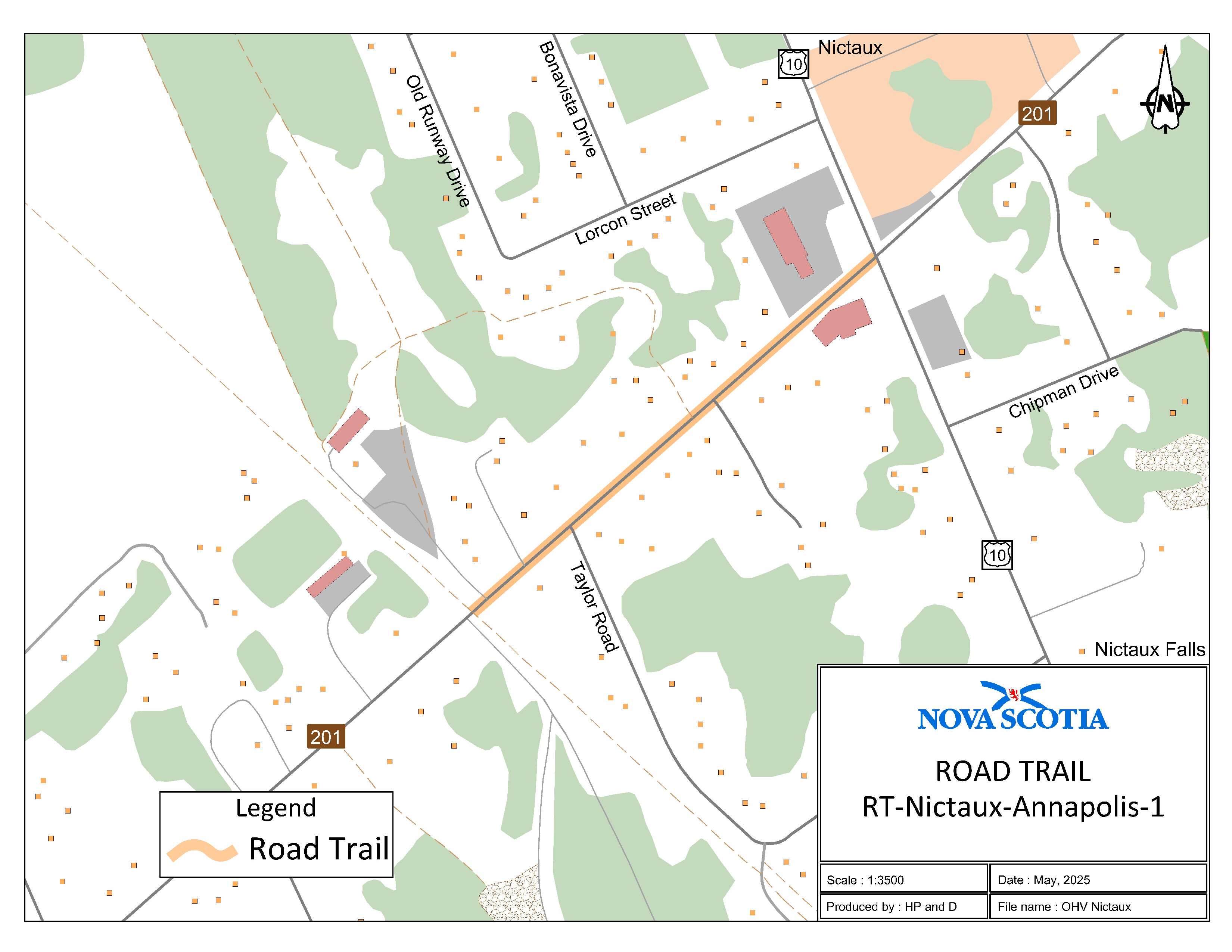
Appendix AG: Nictaux, Annapolis County
The road trail begins at where the trailhead intersects at [with] Route 201 at civic 8751 at coordinates 44.924105°N, 65.052448°W and goes northeast for 0.4 km to the intersection of Trunk 10 and Route 201.
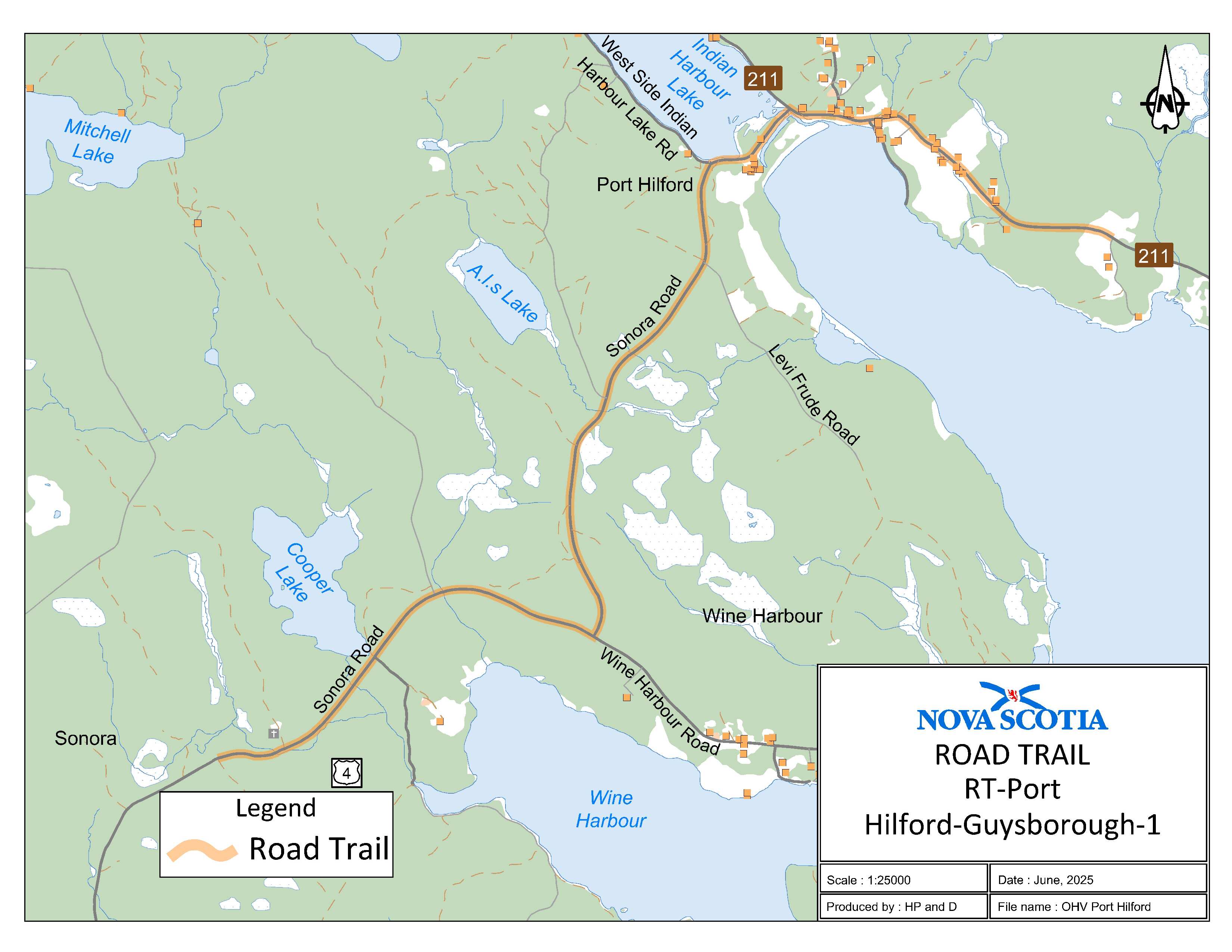
Appendix AH: Port Hilford, Guysborough County
The road trail begins at [the] intersection at the end of Trail 512B and Sonora Road at coordinates 45.074729°N, 61.886626°W and goea [goes] northeast for 6.13 km. The road trail continues on Route 211 and heads east for 1.12 km and ends at coordinates 45.104790°N, 61.833066°W.
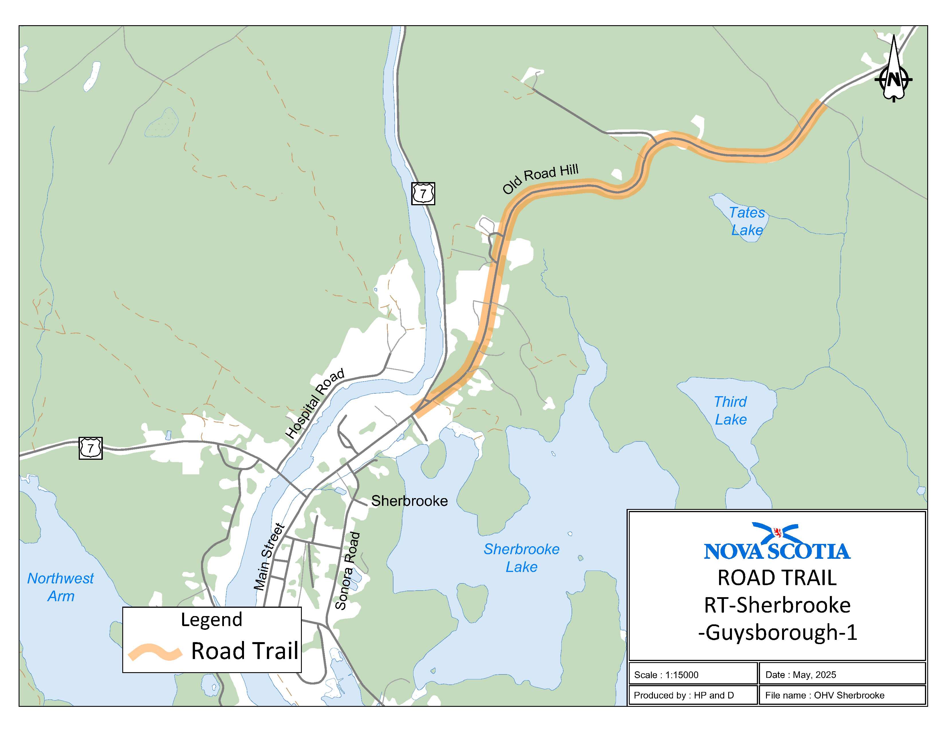
Appendix AI: Sherbrooke, Guysborough County
The road trail begins at the intersection of Old Road Hill and Trunk 7 at coordinates 45.145807°N, 61.976769°W and goes northeast on Old Road Hill for 2.7 km and ends at coordinates 45.158333°N, 61.953776°W.
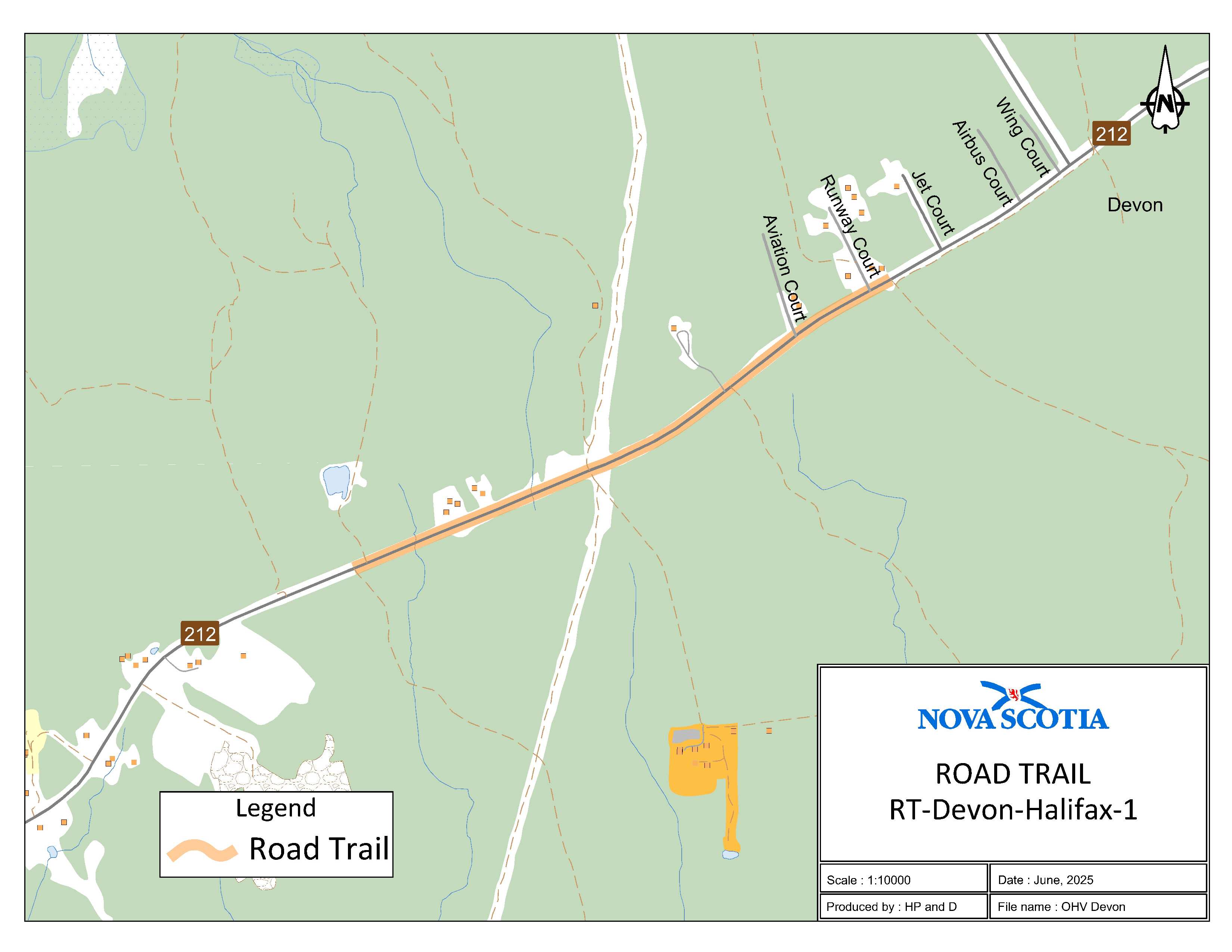
Appendix AJ: Devon, Halifax Regional Municipality
The road trail begins on Route 212 at coordinates 44.8977874°N, 63.445872°W at [and] goes east for 1.39 km. The road trail ends adjacent to civic address 11 Runway Court in Devon at coordinates 44.903600°N, 63.430474°W.
Appendix AK: Guysborough, Guysborough County
The road trail begins at the intersection of New Road, Sunnyville Road, Round Top Road and Prince Street at coordinates 45.389272°N, 61.509330°W and goes east on Prince Street for 0.85 km adjacent to civic 164 Prince Street at coordinates 45.392820°N, 61.500764°W. The road trail continues southeast from the intersection of Prince Street and Church Street on Church Street for 0.18 km.
Appendix AL: Isaacs Harbour, Guysborough County
The road trail begins at the shared use trail 0.1 km west of civic 4465 Larrys River Road at coordinates 45.350773°N, 61.513956°W and goes north for 0.09 km. The road trail ends at the entrance of the shared use rail trail opposite civic 4509 Larrys River Road at coordinates 45.351582°N, 61.513908°W.
Appendix AM: Dean, Halifax Regional Municipality
The road trail begins at civic 311 Stewart Hill Road in Upper Musquodoboit at coordinates 45.161507°N, 62.945957°W and goes north for 1.22 km. The road trail then continues east on Mountain Road for 2.26 km. The road trail continues east on Route 336 and ends adjacent to civic 1008 Route 336 in Dean at coordinates 45.159690°N, 62.906631°W.
Appendix AN: Moser River, Halifax Regional Municipality
The road trail begins at the end of Moser River North Road immediately off Wilson Falls bridge at coordinates 45.021746°N, 62.285809°W heading southeast for 6.2 km.
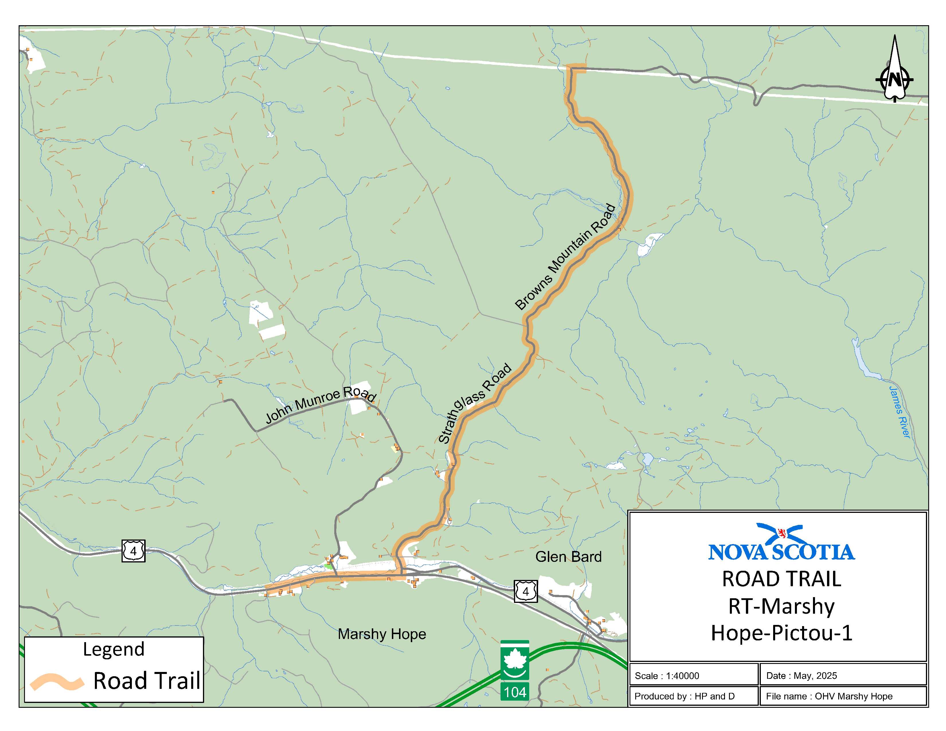
Appendix AO: Marshy Hope, Pictou County
The road trail begins at the intersection of the K-class section of Strathglass Road and the I-class section of Browns Mountain Road at coordinates 45.641805, 62.171600°W and goes south on Browns Mountain Road for 5.2 km. The road trail continues on Strathglass Road going south for 2.6 km. The road trail continues west on Trunk 4 for 1.6 km and ends at coordinates 45.585882°N, 62.219289°W.
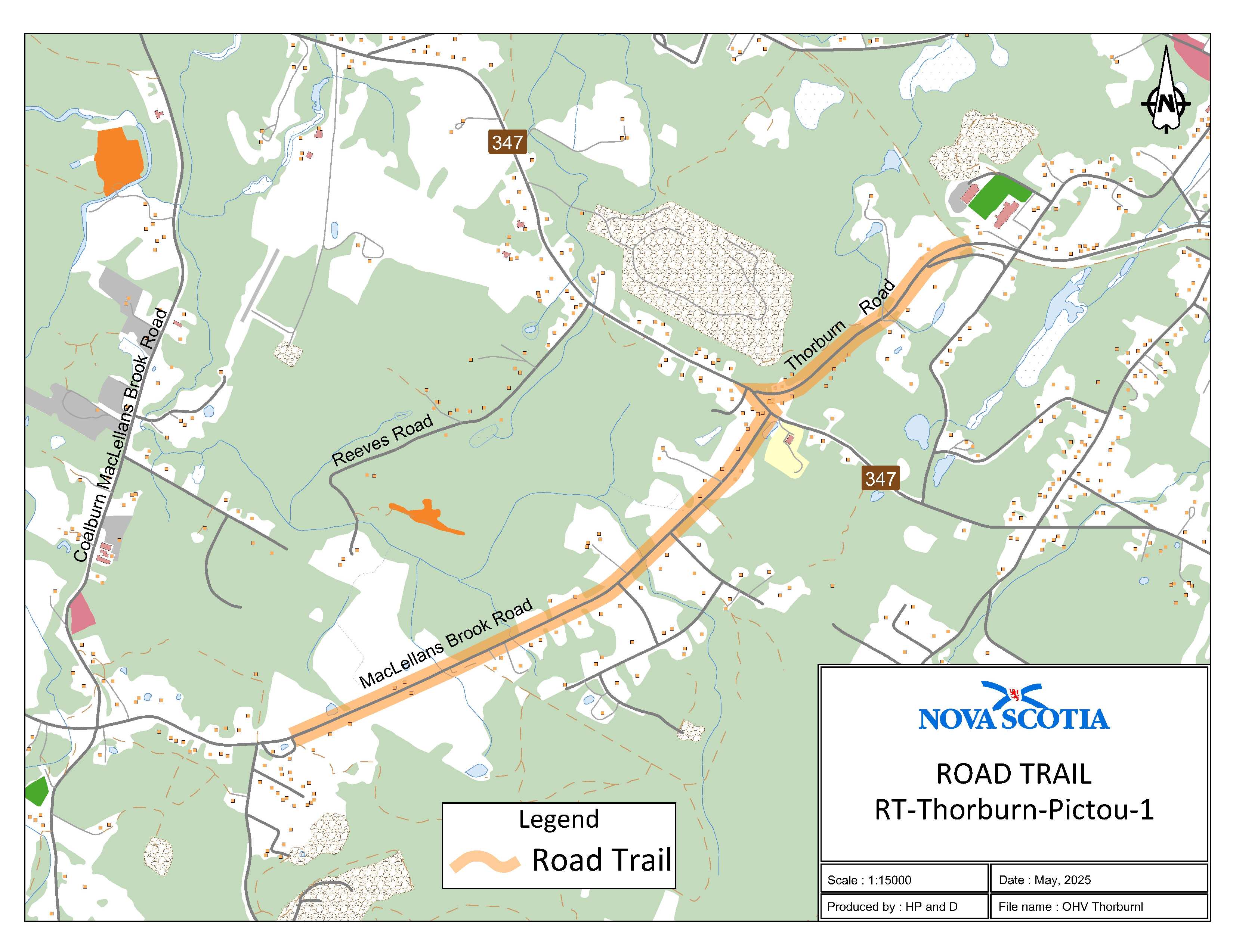
Appendix AP: Thorburn, Pictou County (Thorburn Road)
The road trail begins at coordinates 45.561159°N, 62.565423°W from where the OHV trail meets Thorburn Road and goes in a southwest direction to the intersection of Thorburn Road and Sherbrooke Road for 0.9 km. The second section of the road trail continues in a eastern direction on Route 347 from the intersection of Thorburn Road to Route 347 until it intersects with MacLellans Brook Road. The road trail continues in a western direction down MacLellans Brook Road for 1.9 km until it reaches Glen Road at coordinates 45.545823°N, 62.594539°W.
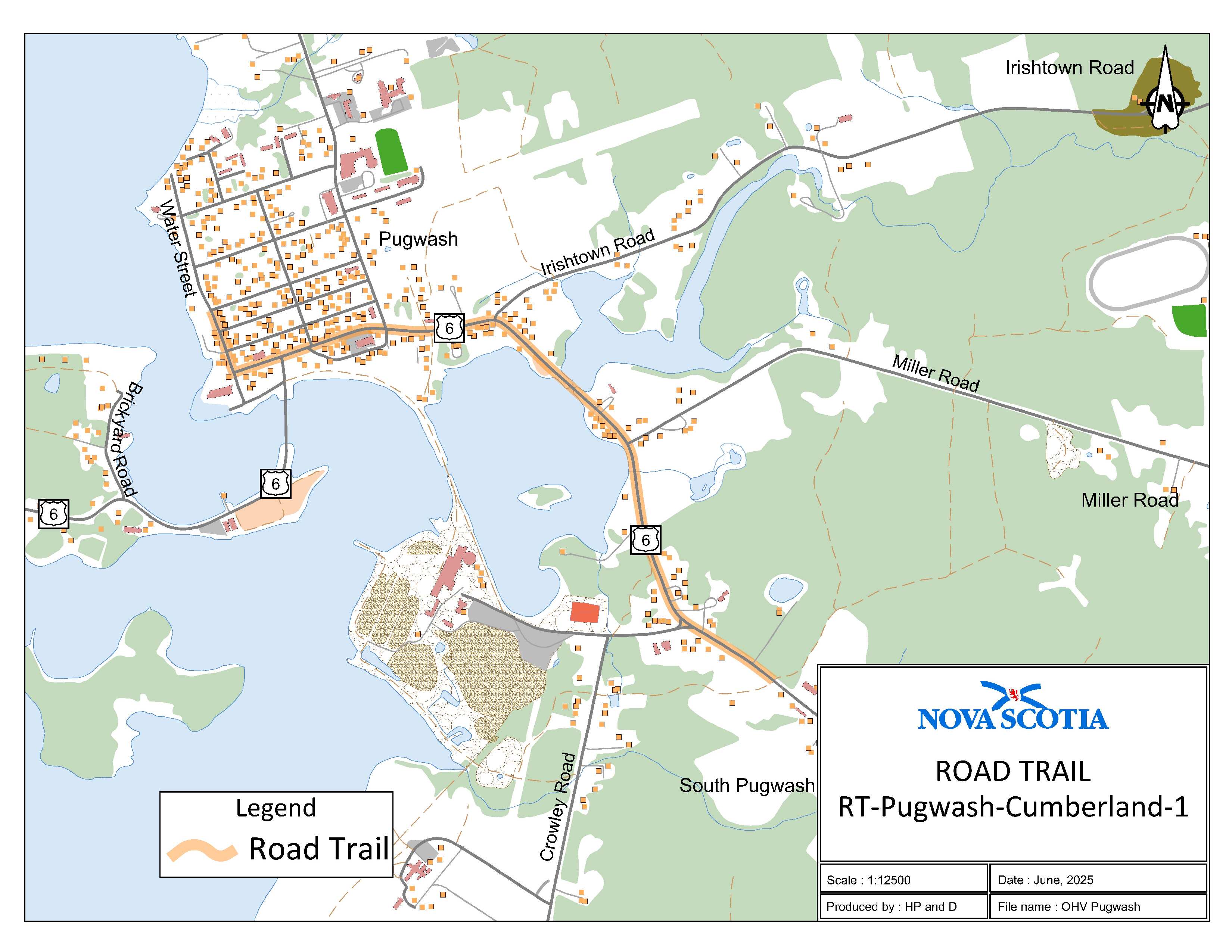
Appendix AQ: Pugwash, Cumberland County
The road trail begins adjacent to civic address 11054 on Trunk 6 at coordinates 45.841539°N, 63.643506°W and goes northwest on Trunk 6 for 2.13 km. The road trail continues on to Water Street for 0.59 km and ends at Cyrus Eaton Park.
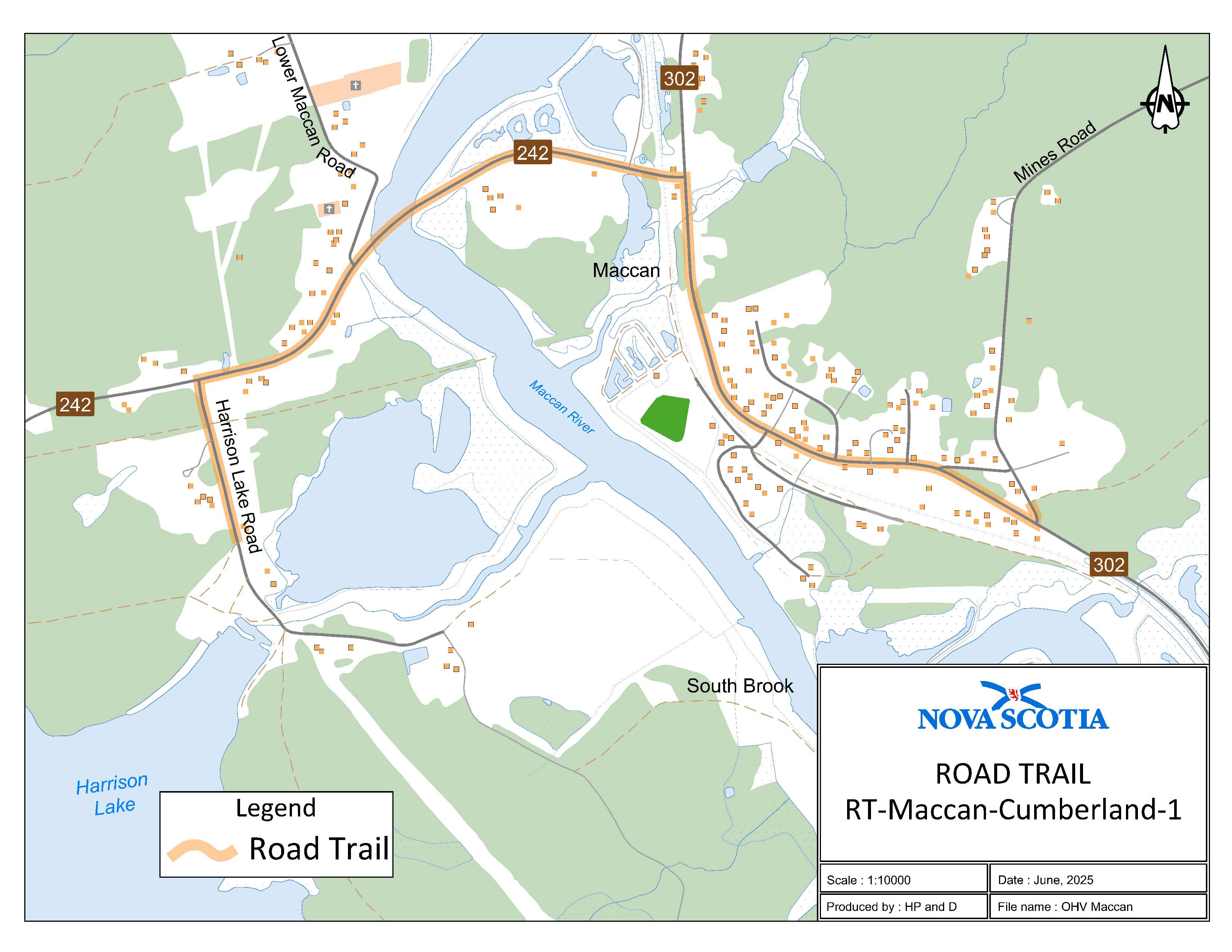
Appendix AR: Maccan, Cumberland County
The road trail begins adjacent to civic 10 Mines Road at coordinates 45.719140°N, 64.241861°W for 0.24 km. The road trail goes west on Route 302 for 1.06 km. The road trail then continues in a southwest direction on Route 242 for 1.31 km. The road trail then continues on Harrison Lake Road for 0.46 km and ends at coordinates 45.718242°N, 64.265047°W.
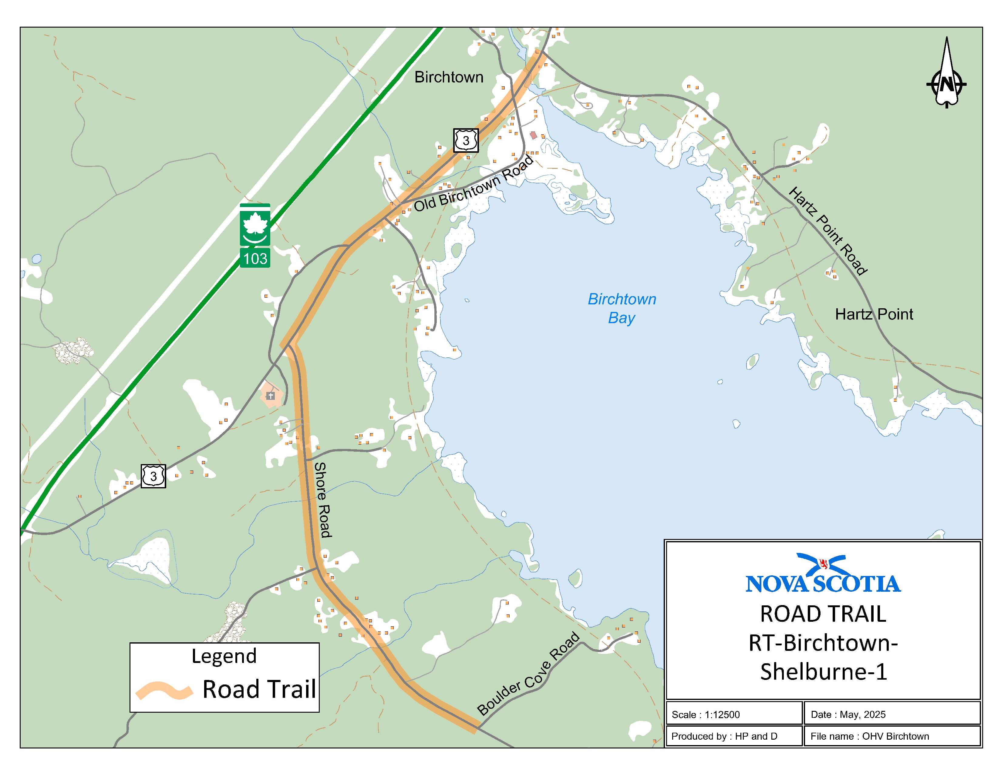
Appendix AS: Birchtown, Shelburne County
The road trail begins at where Hartz Point Road meets Trunk 3 at coordinates 43.749112°N, 65.377501°W. The road trail continues on Trunk 3 in [a] southwestern direction for 1.2 km. The road trail continues on to Shore Road in a southern direction for 1.62 km and ends at coordinates 43.727818°N, 65.379994°W.
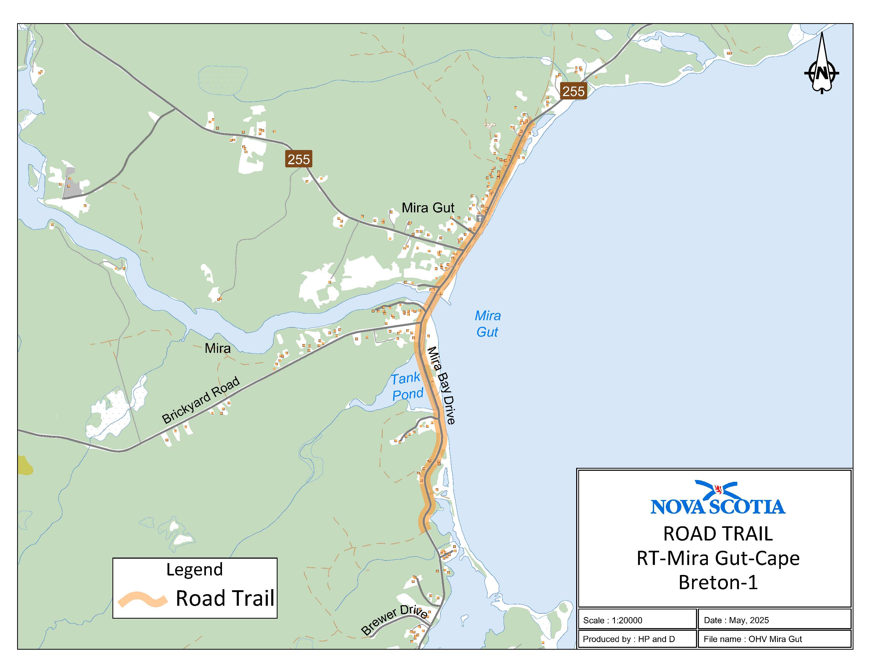
Appendix AT: Mira Gut, Cape Breton Regional Municipality
The road trail begins at the ATV trail 0.2 km north of Lakefront Drive on Mira Bay Drive at coordinates 46.022587°N, 59.969438°W and goes for 2 km. The road trail continues on Route 255 for 1 km and ends at civic 5486 on Route 255 at coordinates 46.046251°N, 59.959844°W.
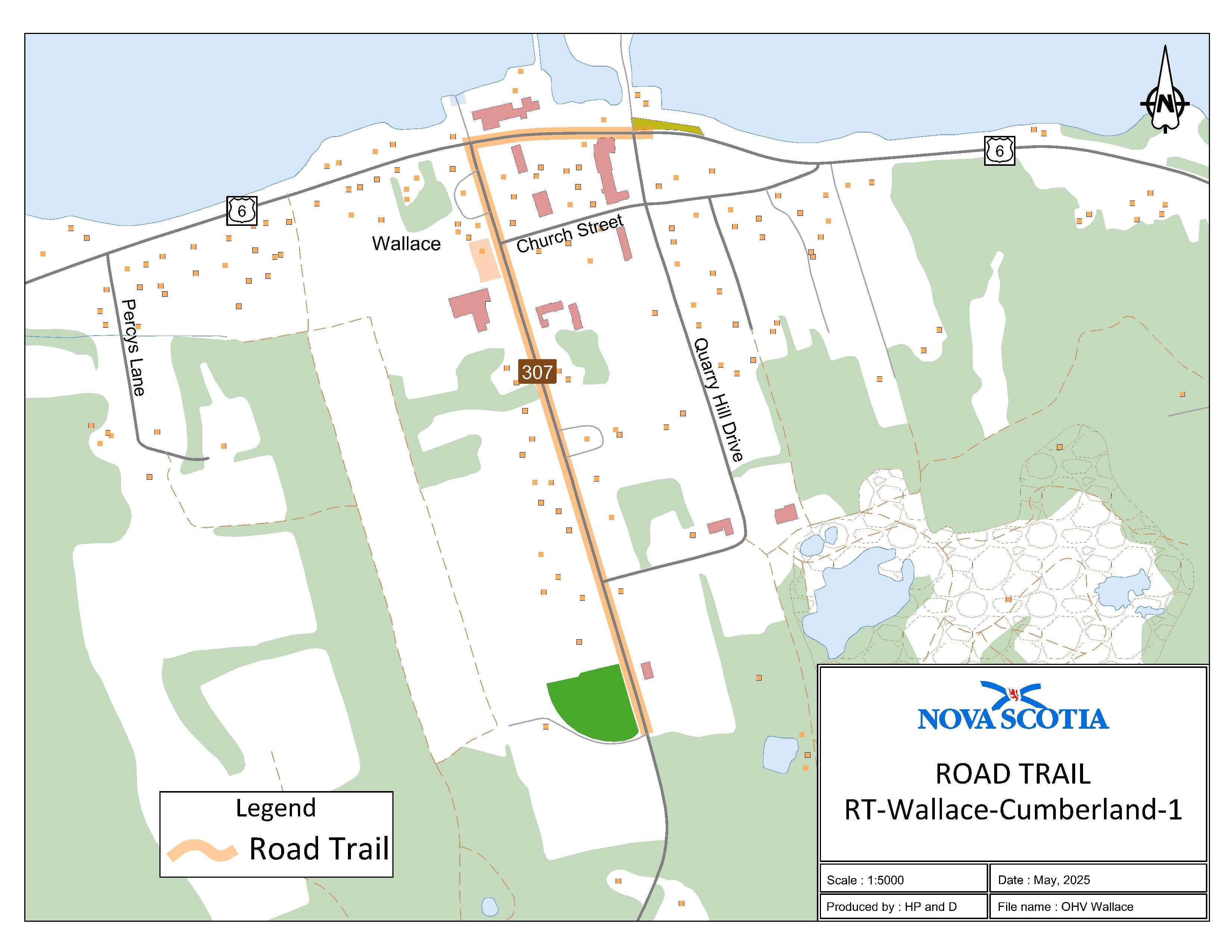
Appendix AU: Wallace, Cumberland County
The road trail begins adjacent to civic 3757 on Route 307 in Wallace at coordinates 45.807676°N, 63.471039°W and goes northwest for 0.7 km. The road trail then continues east on Trunk 6 for 0.2 km and ends at coordinates 45.814043°N, 63.470932°W.