| This consolidation is unofficial and is for reference only. For the official version of the regulations, consult the original documents on file with the Registry of Regulations, or refer to the Royal Gazette Part II. |
| Regulations are amended frequently. Please check the list of Regulations by Act to see if there are any recent amendments to these regulations filed with the Registry that are not yet included in this consolidation. |
| Although every effort has been made to ensure the accuracy of this electronic version, the Registry of Regulations assumes no responsibility for any discrepancies that may have resulted from reformatting. |
| This electronic version is copyright © 2009, Province of Nova Scotia, all rights reserved. It is for your personal use and may not be copied for the purposes of resale in this or any other form. |
Tusket River Ecological Site Designation
made under subsections 14(1) and (3) of the
Special Places Protection Act
R.S.N.S. 1989, c. 438
O.I.C. 89-587 (May 23, 1989), N.S. Reg. 78/2003
as amended by O.I.C. 2006-351 (July 24, 2006), N.S. Reg. 142/2006
O.I.C. 89-587
The Governor in Council on the report and recommendation of the Minister of Education dated the 2nd day of May, A.D., 1989, and pursuant to subsections (1) and (3) of Section 14 of Chapter 17 of the Statutes of Nova Scotia, 1980, the Special Places Protection Act, is pleased to:
(a) rescind Order in Council 87-1475, dated the 8th day of December, A.D., 1987; and
(b) designate the land described in Schedule “A” and as shown on a plan of survey in Schedule “B” attached to and forming part of the report and recommendation as the Tusket River Ecological Site, effective on the date of publication of this designation in the Royal Gazette. [Originally published in the Royal Gazette Part I, May 31, 1989 (Vol. 198, No. 22, p. 2093).]
Schedule “A”
All that certain lot, piece, parcel or tract of land situate, lying and being at South Canaan, in the County of Yarmouth, Province of Nova Scotia, shown on a plan, Field Plot P-030/89, on file at The Department of Lands and Forests Office in Dartmouth, said lot being more particularly bounded and described as follows:
Beginning at S. M. Y636 set on the southeastern boundary of Canaan Road at the most northerly corner of lands of Greg Dean;
Thence N 57° 14' 25" E distant 1737.92' along the said southeastern boundary of Canaan Road to S. M. Y637;
Thence S 56° 54' 45" E distant 989.76' along the southwestern boundary of lands of Alfred Hurlburt to S. M. Y638;
Thence S 56° 54' 45" E distant 15'+ along the said southwestern boundary of lands of Alfred Hurlburt to the Ordinary High Water Mark of Wilsons Lake;
Thence Southwesterly distant 1750'+ along the said Ordinary High Water Mark of Wilsons Lake to a point being S 51° 39' 42" E distant 10'+ from S. M. Y639;
Thence N 51° 39' 42" W distant 10'+ along the northeastern boundary of said lands of Greg Dean to S. M. No. Y639;
Thence N 51° 39' 42" W distant 1762.87' along the said northeastern boundary of lands now or formerly of Greg Dean to the Place of Beginning.
The above described lot having an area of 54.2 acres+.
The above described bearings are magnetic for the year 1982.
Together with a small island as shown on Field Plot P-030/89 containing one acre+ and lying to the east of the above described lot.
O.I.C. 2006-351
The Governor in Council on the report and recommendation of the Minister of Environment and Labour dated July 11, 2006, and pursuant to Section 14 of Chapter 438 of the Revised Statutes of Nova Scotia, 1989, the Special Places Protection Act, is pleased, effective on and after July 24, 2006, to
(a) [filed as N.S. Reg. 138/2006 - 141/2006];
(b) approve of an amendment to the Tusket River Ecological Site Designation, N.S. Reg. 78/2003, made by the Minister of Education and approved by Governor in Council by Order in Council 89-587 dated May 23, 2989, to add certain lands to be included as part of the Tusket River Ecological Site, in the manner set forth in Schedule “E” attached to and forming part of the report and recommendation.
In the matter of Section 14 of Chapter 438 of the Revised Statutes of Nova Scotia, 1989, the Special Places Protection Act
- and -
In the matter of an additional designation of land near East Quinan, Yarmouth County, to the Tusket River Ecological Site
I, Mark Parent, Minister of Environment and Labour for the Province of Nova Scotia, pursuant to Section 14 of Chapter 438 of the Revised Statutes of Nova Scotia, 1989, the Special Places Protection Act, hereby designate the area of land described in Appendix A and shown on the map in Appendix B, attached to and forming part of this order, as an addition to the Tusket River Ecological Site, as designated by the Minister of Education and approved by the Governor in Council by Order in Council 89-587 dated May 23, 1989.
The written consent of the landowner has been granted and has been filed with the Department of Environment and Labour.
This designation is effective on and after the date it is published in the Royal Gazette.
Dated and made at Halifax Regional Municipality, Province of Nova Scotia, July 11, 2006.
Sgd.: Mark Parent
Honourable Mark Parent
Minister of Environment and Labour
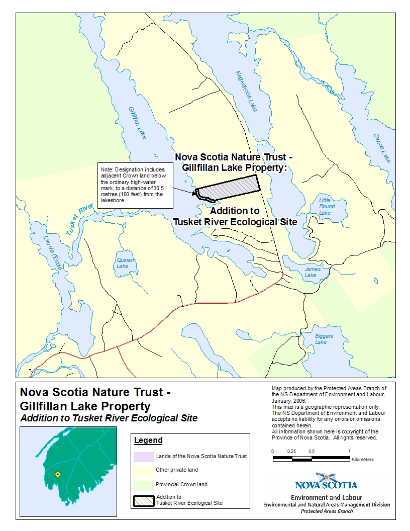
Appendix A
Addition to Tusket River Ecological Site
(Ecological Site originally designated under O.I.C 89-587)
All that certain lot, piece and parcel of land and land covered by water situate, lying and being on the western side of the Main Public Highway at East Quinan, Yarmouth County, Nova Scotia and being a portion of the lands and premises shown on a plan of survey prepared by Gerald A. Pottier N.S.L.S. No. 394 dated the 12th day of July, A.D., 1972, together with lands belonging to Her Majesty in Right of the Province of Nova Scotia below the mean highwater mark of Gilfilling Lake, said lands and premises being more particularly bounded and described as follows:
Beginning at an iron post located on the western official sideline of the Main Public Road leading from East Quinan to Kegeshock at the northeast corner of lands now or formerly of Eddie Surette;
Thence North eighty-five degrees fifty-seven minutes West (N 85o 57' W) a distance of one thousand eight hundred fifty-eight decimal seven nine feet (1858.79') to an iron post;
Thence North eighty-five degrees fifty-seven minutes West (N 85o 57' W) a distance of twenty-seven decimal five feet (27.5') more or less to a point on the mean highwater mark of Gilfilling Lake;
Thence continuing lakeward at right angles (90o) to the mean highwater mark (shoreline) of Gilfilling Lake a distance of one hundred feet (100') to a point;
Thence in a westerly and northerly direction parallel to the various courses of the mean highwater mark of Gilfilling Lake a distance of one thousand two hundred twenty-five feet (1225') more or less to a point;
Thence continuing landward a distance of one hundred feet (100') to a point on the mean highwater mark of Gilfilling Lake;
Thence South eighty-five degrees thirty-seven minutes East (S 85o 37' E) a distance of eight feet (8') more or less to an iron post, said iron post being located North forty-one degrees forty-seven minutes West (N 41o 47' W) a distance of nine hundred sixty-eight decimal six three feet (968.63') from the last mentioned iron post;
Thence South eighty-five degrees thirty-seven minutes East (S 85o 37' E) a distance of two thousand five hundred fifty-five decimal zero two feet (2555.02') to an iron post on the western official sideline of the Main Public Road leading from East Quinan to Kegeshock;
Thence South zero four degrees ten minutes West (S 04o 10' W) a distance of six hundred fifty-nine decimal seven one feet (659.71') to an iron post and the place of beginning.
All bearings refer to Magnetic North for the year 1972.
Containing a total area of 40 acres more or less.
Appendix B
Map of Addition to Tusket River Ecological Site