| This consolidation is unofficial and is for reference only. For the official version of the regulations, consult the original documents on file with the Registry of Regulations, or refer to the Royal Gazette Part II. |
| Regulations are amended frequently. Please check the list of Regulations by Act to see if there are any recent amendments to these regulations filed with the Registry that are not yet included in this consolidation. |
| Although every effort has been made to ensure the accuracy of this electronic version, the Registry of Regulations assumes no responsibility for any discrepancies that may have resulted from reformatting. |
| This electronic version is copyright © 2009, Province of Nova Scotia, all rights reserved. It is for your personal use and may not be copied for the purposes of resale in this or any other form. |
French Mill Brook Watershed Protected Water Area Designation
made under Section 106 of the
Environment Act
S.N.S. 1994-95, c. 1
N.S. Reg. 148/2004 (May 3, 2004)
as amended by N.S. Reg. 213/2007 (April 13, 2007)
In the Matter of: the Environment Act, S.N.S. 1994-95, c.1, s.106
In the Matter of: the designation of an area surrounding French Mill Brook, Hants County, as a Protected Water Area, to be known as the “French Mill Brook Watershed Protected Water Area”
Designation of the French Mill Brook Watershed Protected Water Area and the Making of Regulations with Respect Thereto
Whereas on March 23, 1983 the Minister of the Environment, at the request of the Municipality of the District of West Hants, operator of the water supply and water works for Falmouth, and pursuant to Section 17 of the Water Act (c. 335, RSNS, 1967 as amended) designated by Order, an area surrounding French Mill Brook, Hants County, as a Protected Water Area;
Whereas the French Mill Brook watershed designation and regulations governing activities in the Protected Water Area were published in the Royal Gazette [Part I] on April 6, 1983 pursuant to section 17(3) of the Water Act;
Whereas Section 106 of Chapter 1 of the Acts of 1994-95, the Environment Act, provides for the designation by the Minister of Environment and Labour of a protected water area and the making of regulations under subsection (6) to prohibit, regulate or require the doing of any act or acts in a protected water area that may impair or prevent the impairment, as the case may be, of the quality of the water in the Protected Water Area;
Whereas subsection 106(5) of the Environment Act states that any protected water area designated pursuant to the Water Act, prior to the coming into force of the Environment Act remains so designated;
Whereas protected water area designations and regulations are to be filed and published pursuant to Sections 3 and 4 of the Regulations Act, and the French Mill Brook watershed designation and regulations have not been filed to date;
Therefore pursuant to Section 106 of Chapter 1 of the Acts of 1994-95, the Environment Act, the undersigned, Kerry Morash, Minister of Environment and Labour hereby
(a) ratifies the French Mill Brook Watershed Protected Water Area designation made March 23, 1983 pursuant to subsection 17(1) of the Water Act, and confirms that the designated area described in Schedule “A” remains so designated;
(b) repeals regulations made March 23, 1983 pursuant to subsection 17(2) of the Water Act and makes regulations respecting activities in the French Mill Brook Watershed Protected Water Area, in the form set forth in Schedule “B”; and
(c) on behalf of the Municipality of the District of West Hants, operator of the Falmouth water works, directs the Department of Environment and Labour to file the French Mill Brook Watershed Protected Water Area designation and regulations with the Registrar of Regulations pursuant to the Regulations Act.
Sgd: K. Morash
Honourable Kerry Morash
Minister of Environment and Labour
Halifax, Nova Scotia May 3, 2004
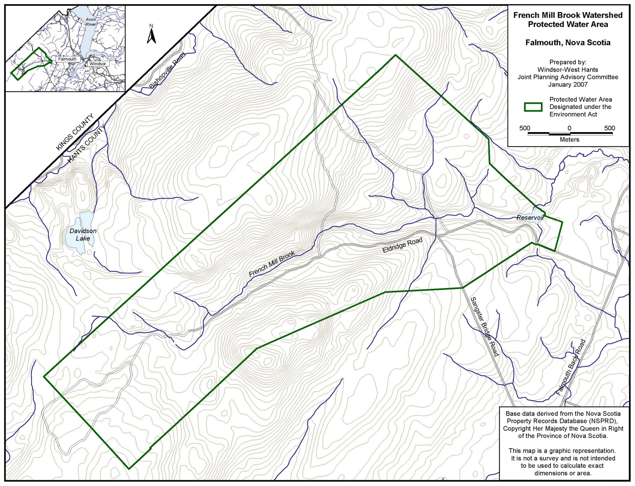
Schedule “A”
French Mill Brook Watershed Protected Water Area Boundary Description
All those lands situate in the Township of Falmouth and wholly within the County of Hants, Province of Nova Scotia, comprising an approximate area of Two Thousand Eight Hundred and Fourteen acres according to a Plan prepared the 29th day of April, A.D., 1974, and recorded at the Registry of Deeds for Hants County on 23rd day of April, A.D., 1975 as Plan No. P-1005, said Plan being amended and filed at the Registry of Deeds for Hants County on the 7th day of December, A.D., 1982 as Plan No. P-3742, and being more particularly described as follows:
BEGINNING at a point, said point being an iron stake marking the southeastern corner of lands of the Municipality of the District of West Hants and the northern corner of lands of Bernard Curry and a western corner of lands of T. Mouris, as shown on said plan of survey;
THENCE on a bearing north nine degrees fifty-four minutes west a distance of two hundred and fifty-five feet to a point;
THENCE on a bearing north twenty-seven degrees west a distance of three thousand three hundred and sixty-two feet to a point;
THENCE on a bearing north five degrees fifty minutes east a distance of nine hundred and twenty-three feet to a point;
THENCE on a bearing north twenty-seven degrees thirty minutes west a distance of five thousand one hundred and one feet to a point;
THENCE on a bearing south sixty-eight degrees west along the old base line a distance of eighteen thousand and ninety-six feet to a pint [point];
THENCE on a bearing south twenty-two degrees east a distance of five thousand one hundred and thirty-seven feet to a point;
THENCE on a bearing north sixty-eight degrees east a distance of six thousand two hundred and ten feet to a point;
THENCE on a bearing north eighty-three degrees twenty minutes east a distance of five thousand nine hundred and fifty-five feet to a point;
THENCE on a bearing south sixty-eight degrees forty minutes east a distance of two thousand nine hundred and thirty-six feet to a point;
THENCE on a bearing north eighty-three degrees twenty minutes east a distance of three thousand two hundred feet to an iron stake;
THENCE along the center line of the Eldridge Settlement Road in a southeasterly direction a distance of one thousand and fifteen feet more or less to a point;
THENCE on a bearing north thirty-nine degrees eleven minutes east a distance of six hundred and six feet more or less to a point;
THENCE on a bearing north twenty-eight degrees zero six minutes east a distance of five hundred and sixty-five feet to a maple tree;
THENCE on a bearing north forty-nine degrees seventeen minutes west a distance of four hundred and five feet to the place of beginning.
The boundaries set out above are approximated on the map attached as Appendix A.
Boundary description amended: N.S. Reg. 213/2007.
Appendix A–Map of Approximate Boundaries
of French Mill Brook Watershed Protected Water Area
Appendix “A” Map added: N.S. Reg. 213/2007.