| This consolidation is unofficial and is for reference only. For the official version of the regulations, consult the original documents on file with the Registry of Regulations, or refer to the Royal Gazette Part II. |
| Regulations are amended frequently. Please check the list of Regulations by Act to see if there are any recent amendments to these regulations filed with the Registry that are not yet included in this consolidation. |
| Although every effort has been made to ensure the accuracy of this electronic version, the Registry of Regulations assumes no responsibility for any discrepancies that may have resulted from reformatting. |
| This electronic version is copyright © 2009, Province of Nova Scotia, all rights reserved. It is for your personal use and may not be copied for the purposes of resale in this or any other form. |
Joggins Fossil Cliffs Protected Site Designation
made under Section 14 of the
Special Places Protection Act
R.S.N.S. 1989, c. 438
N.S. Reg. 53/2006 (February 24, 1972)
as amended by O.I.C. 2007-201 (April 4, 2007, effective April 27, 2007), N.S. Reg. 210/2007
N.S. Reg. 53/2006
In the matter of Chapter 8 of the Acts of 1970,
the Historical Objects Protection Act
- and -
In the matter of the designation of the certain lands at or near Joggins in the
County of Cumberland and Province of Nova Scotia as a Protected Site
Whereas Section 2 of Chapter 8 of the Acts of 1970, the Historical Objects Protection Act provides that the Minister of Education may designate any land within the Province that has archeological, historical or palaeontological significance as a protected site.
And whereas that certain piece or area of land commonly known as the Fossil Cliffs, situate and being at or near Joggins in the County of Cumberland and Province of Nova Scotia is land having such significance.
Now therefore pursuant to the power vested in me by Section 2 of the Historical Objects Protection Act, I, the undersigned Minister of Education, do hereby designate as a protected site under the said Historical Objects Protection Act that certain piece or area of land commonly known as the Fossil Cliffs, situate and being at or near Joggins, in the County of Cumberland and Province of Nova Scotia, and being more particularly described as follows:
[Land description and plan attached as Schedule “A” replaced by Appendixes “A” and “B” to N.S. Reg. 210/2007.]
Sgd.: Peter Nicholson
Feb 24/1972 Minister of Education
N.S. Reg. 210/2007
In the matter of Section 7 of Chapter 438 of the Revised Statutes of Nova Scotia,
1989, the Special Places Protection Act
- and -
In the matter of an amendment to the designation of land at or near Joggins
in the County of Cumberland as the Joggins Fossil Cliffs Protected Site
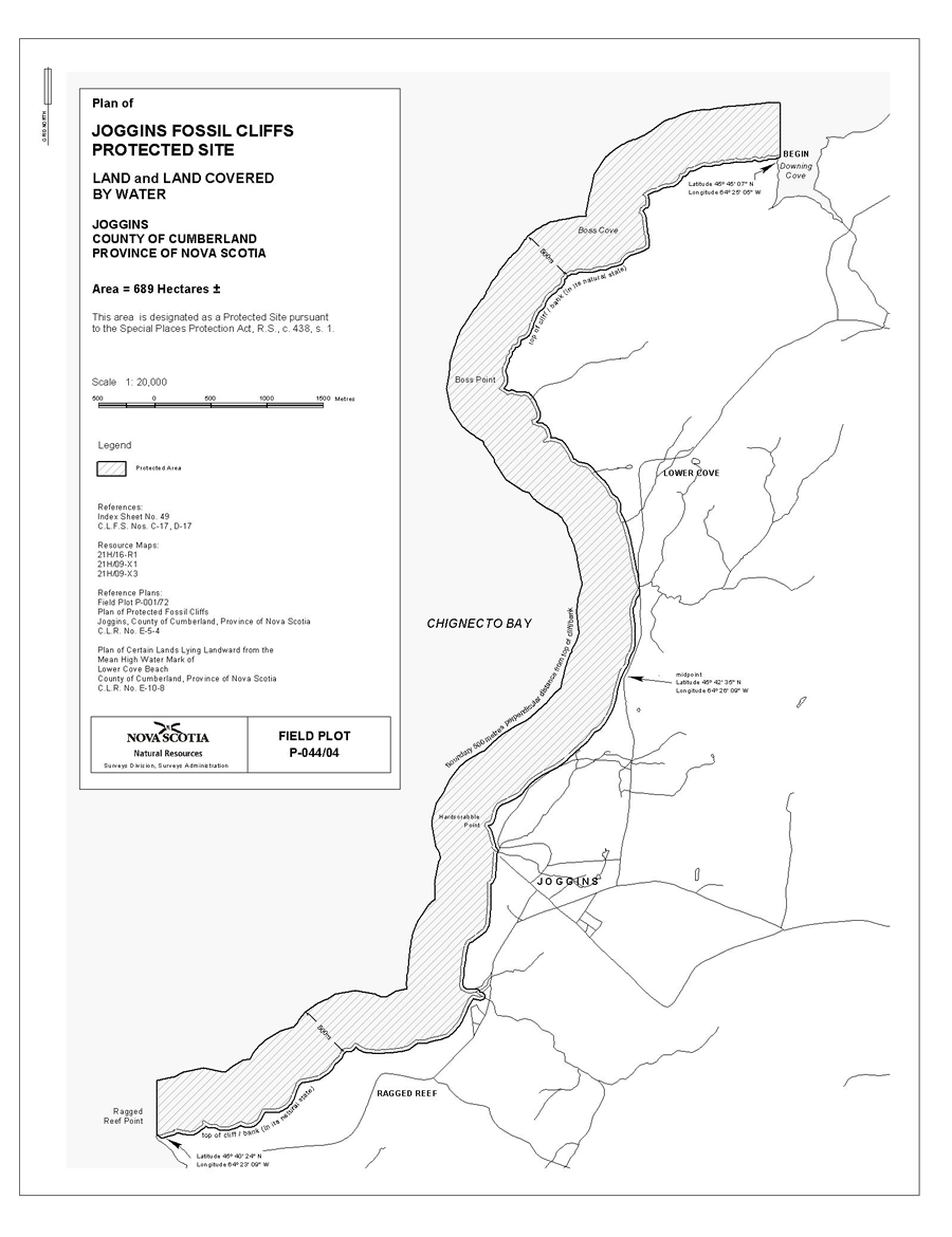
I, Len Goucher, Minister of Tourism, Culture and Heritage for the Province of Nova Scotia, pursuant to Section 7 of Chapter 438 of the Revised Statutes of Nova Scotia, 1989, the Special Places Protection Act, hereby amend the designation of the Joggins Fossil Cliffs Protected Site, N.S. Reg. 53/2006, made by the Minister of Education on February 24, 1972, pursuant to Chapter 8 of the Acts of 1970, the Historical Objects Protection Act, to add certain lands to be included as part of the Joggins Fossil Cliffs Protected Site. The additional lands hereby designated, together with the lands previously designated, are described in Appendix “A” and shown on the map in Appendix “B” attached to and forming part of this order.
Appendix “A”
Joggins Fossil Cliffs Protected Site
All that certain tract of land and land covered by water as shown on a Plan of Joggins Fossil Cliffs Protected Site at Joggins in the County of Cumberland, Province of Nova Scotia, on file at Department of Natural Resources Office at Halifax under Field Plot P-044/04 and being more particularly described as follows:
Beginning at the northeastern point at the top of the cliff or bank (in its natural state) on the eastward side of Chignecto Bay, on the west side of the mouth of Downing Cove;
Thence southwesterly and following the various courses of the top of the cliff or bank (in its natural state) and extending across the mouth of all tributaries on the eastward side of Chignecto Bay, to the northwestern point of Ragged Reef Point;
Thence due grid north seaward to a point being located at a perpendicular distance of 500 metres northerly from the top of the cliff or bank, on the eastward side of Chignecto Bay;
Thence in a generally northeasterly direction remaining parallel to and 500 metres perpendicularly distant from the top of the cliff or bank on the eastward side of Chignecto Bay, to a point being located due grid north from the Place of beginning;
Thence due grid south to the Place of beginning.
Containing an approximate area of 689 hectares.
The above described parcel having a seaward boundary lying 500 metres perpendicularly distant from the top of the cliff or bank and having a landward boundary that will follow parallel to the top of the cliff or bank, as its location varies over time.
Appendix “B”
Map of Joggins Fossil Cliffs Protected Site
