| This consolidation is unofficial and is for reference only. For the official version of the regulations, consult the original documents on file with the Office of the Registrar of Regulations, or refer to the Royal Gazette Part II. |
| Regulations are amended frequently. Please check the list of Regulations by Act to see if there are any recent amendments to these regulations filed with our office that are not yet included in this consolidation. |
| Although every effort has been made to ensure the accuracy of this electronic version, the Office of the Registrar of Regulations assumes no responsibility for any discrepancies that may have resulted from reformatting. |
| This electronic version is copyright © , Province of Nova Scotia, all rights reserved. It is for your personal use and may not be copied for the purposes of resale in this or any other form. |
Lower Truro Marshland Section Variation Order
made under Section 13 of the
Agricultural Marshland Conservation Act
S.N.S. 2000, c. 22
N.S. Reg. 191/2026 (effective August 21, 2026)
Table of Contents
Please note: this table of contents is provided for convenience of reference and does not form part of the regulations.
Click here to go to the text of the regulations.
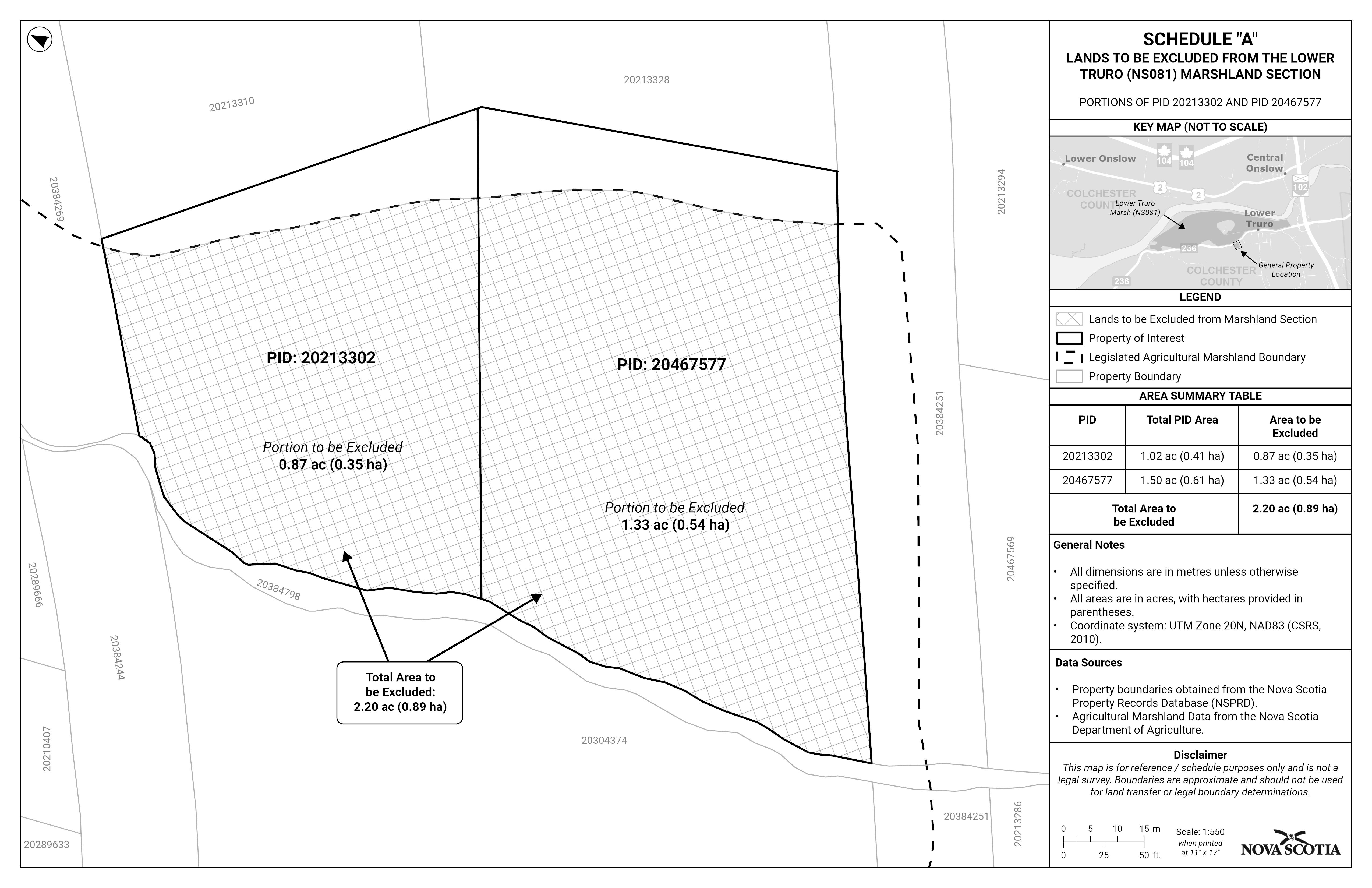
Schedule A—Map of Lands to be Excluded from Lower Truro Marshland Section
Whereas the Lower Truro Marsh Body was incorporated on June 18, 1953;
And whereas the lands described in the Certificate of Incorporation for the Lower Truro Marsh Body are shown in the Plan of Works Lower Truro Marsh, NS 81/6, Sheets 1 and 2 of 2;
And whereas, in accordance with clause 13(1)(a) of the Agricultural Marshlands Conservation Act (the “Act”), the Agricultural Marshland Conservation Commission recommends that the boundaries of the marshland section for which the Lower Truro Marsh Body is incorporated be varied to exclude approximately 0.89 ha (2.20 acres) of land presently identified as portions of PID 20213302 and PID 20467577 from the marshland section;
And whereas I am satisfied that, in accordance with clause 13(1)(b) of the Act, a resolution requesting the variation was passed at a special meeting of the members of the Lower Truro Marsh Body by a vote of not fewer than two thirds of the members of the Lower Truro Marsh Body present at the meeting and that the owners of not less than two thirds of the marshland proposed to be excluded favour the variation;
Therefore, I, Greg Morrow, Minister of Agriculture, pursuant to Section 13 of Chapter 22 of the Acts of 2000, the Agricultural Marshland Conservation Act, hereby vary the boundaries of the marshland section for which the Lower Truro Marsh Body is incorporated by excluding approximately 0.89 ha (2.20 acres) of land presently identified as portions of PID 20213302 and PID 20467577 from the marshland section, as set forth in the attached Schedule “A”.
This order is effective on and after the date it is filed with the Registrar of Regulations.
Dated and made August 21, 2026, at Halifax Regional Municipality, Province of Nova Scotia.
sgd. Greg Morrow
The Honourable Greg Morrow
Minister of Agriculture
The following is a description of the approximately 0.89 ha (2.20 acres) to be excluded from the marshland section for which the Lower Truro Marsh Body is incorporated, presently identified as being portions of PID 20213302 and PID 20467577 and shown in a map in Schedule A, and which are more particularly described as follows:
All and singular that certain piece, part, or parcel of land situate in the vicinity of Lower Truro, Colchester County, Nova Scotia, being shown on a plan filed at the Registry of Deeds for Colchester County on July 17, 2012, as plan number 101126655, and being more particularly described as follows:
Beginning at an iron post situate on the Southern boundary of the Lower Truro Road and the Eastern bank of Soley Brook, so-called;
Thence North seventy-four degrees, twenty minutes East (N 74 degrees 20 minutes E) along the Southern boundary of the Lower Truro Road a distance of one hundred and ten (110) feet to an iron post situate at the toe of the bank and the West boundary of lands now or formerly of Ron Joyce;
Thence South twenty-six degrees, twenty-five minutes East (S 26 degrees 25 minutes E) along the toe of the bank and the West boundary of lands now or formerly of Ron Joyce a distance of one hundred and forty-three (143) feet to an iron post situate on the North boundary of lands of A.H. Sandeson;
Thence South eighty-nine degrees zero zero minutes West (S 89 degrees 00 minutes W) along a marsh ditch and the North boundary of lands of A.H. Sandeson a distance of two hundred and nine point two (209.2) feet to an iron post situate in a marsh ditch;
Thence North zero zero degrees eleven minutes East (N 00 degrees 11 minutes E) along the marsh ditch and the East boundary of A.H. Sandeson, a distance of seventy-nine point two (79.2) feet to an iron post situate on the South bank of Soley Brook;
Thence North fifty-nine degrees, fifty-two minutes East (N 59 degrees 52 minutes E) along the South bank of Soley Brook a distance of forty-five point five (45.5) feet to an iron post being the place of beginning
Containing 19,870 square feet or 0.46 acres.
And also all that certain lot, piece, or parcel of land situate, lying, and being to the south but not adjoining Highway No. 236, at Lower Truro, in the County of Colchester, Province of Nova Scotia, and being Lot 90-B as shown on a plan showing subdivision lands of Alfred H. Sandeson, dated April 18, 1990, signed by Kenneth P. MacDonald, N.S. Land Surveyor, bounded and described as follows:
Beginning at a survey marker on the Southeastern corner of lands of Cobequid District Fire Brigade on the Western boundary of lands now or formerly of Ronald S. Joyce;
Thence South 24 degrees 00 minutes East along the Western boundary of lands now or formerly of Ronald S. Joyce a distance of 57.63 feet to a survey marker on the Southwestern corner of said lands now or formerly of Ronald S. Joyce;
Thence South 7 degrees 08 minutes West along the Western boundary of lands now or formerly of Donald H. Joyce a distance of 14.7 feet to a survey marker;
Thence South 81 degrees 02 minutes West a distance of 287.8 feet to a witness survey marker; thence continuing in the same course South 81 degrees 02 minutes West a distance of 4 feet more or less to the Eastern boundary of the Soley Brook;
Thence Northerly following along the various courses of the Soley Brook to lands of Cobequid District Fire Brigade;
Thence South 3 degrees 26 minutes West along the Western boundary of lands of Cobequid District Fire Brigade a distance of 85.2 feet more or less to an iron bar on the Southwestern corner of said lands of Cobequid District Fire Brigade;
Thence South 89 degrees 28 minutes East along the Southern boundary of lands of Cobequid District Fire Brigade a distance of 209.2 feet to a survey marker on the Southeastern corner of said lands of Cobequid District Fire Brigade on the Western boundary of lands now or formerly of Ronald S. Joyce and the place of beginning.
And also a lot of land located at Lower Truro, Colchester County, Nova Scotia, more particularly bounded and described as follows:
Commencing at the Southeast corner of the Soley Brook Bridge on Highway 236;
Thence following the course of the Soley Brook in a Southerly direction to the Southwest corner of lands of the Cobequid District Fire Brigade;
Thence Easterly to lands of Don Joyce;
Thence Southerly along lands of Joyce, Blair Kent, and The Nova Scotia Farm Loan Board to the point of intersection of the Kent Brook and Soley Brook;
Thence Westerly following the Soley Brook to a gully;
Thence following the gully to lands of Prodger;
Thence Northerly along lands of Prodger and Frank Sandeson to Highway 236;
Thence Easterly along Highway 236 to the point of beginning at the Soley Brook Bridge.
Containing by approximation seventy-five (75) acres.
Being a portion of the first described lot (150 acres) contained in a deed from Richard A. Sandeson to Alfred H. Sandeson dated April 7, 1962, and recorded at the Registry of Dee[d]s for Colchester County in Book 300, page 497.
Areas excluded from Areas 3:
Saving and excepting all of the above described lands being to the South of the Soley Brook Loop and also saving and excepting the Soley Brook Loop.
Also saving and excepting all of the above described lands being to the South of the Old Road and also saving and excepting the Old Road.
Also saving and excepting all of the above described lands being to the West of the Soley Brook and also saving and excepting the Soley Brook.
Also saving and excepting that lot as described in a deed recorded at the Registry of Deeds for Colchester County on January 6, 1972, in Book 372 at page 525.
Also saving and excepting Lot 90-B as described in a deed recorded at the Registry of Deeds for Colchester County on June 11, 1990, in Book 674 at page 49.
Schedule A—Map of Lands to be Excluded from Lower Truro Marshland Section
Legislative History
Reference Tables
Lower Truro Marshland Section Variation Order |
N.S. Reg. 191/2026 |
Agricultural Marshland Conservation Act |
|
Note: The information in these tables does not form part of the regulations and is compiled by the Office of the Registrar of Regulations for reference only. |
|
Source Law
The current consolidation of the Lower Truro Marshland Section Variation Order made under the Agricultural Marshland Conservation Act includes all of the following regulations:
N.S. |
In force |
How in force |
Royal Gazette |
191/2026
|
Aug 21, 2026 |
date specified |
Sep 4, 2026 |
|
|
|
|
|
|
|
|
|
|
|
|
|
|
|
|
The following regulations are not yet in force and are not included in the current consolidation:
N.S. |
In force |
How in force |
Royal Gazette |
|
|
|
|
|
|
|
|
|
|
|
|
*See subsection 3(6) of the Regulations Act for
rules about in force dates of regulations.
ad. = added |
fc. = fee change |
rep. = repealed |
|
Provision affected
|
How affected
|
||
.......................................................... |
|
||
|
|
||
|
|
||
|
|
||
|
|
||
Note that changes to headings are not included in the above table unless specifically referenced.
Editorial Notes and Corrections
|
Note |
Effective |
|
|
|
|
|
|
|
|
|
Repealed and Superseded
N.S. |
Title |
In force |
Repealed |
|
|
|
|
Note: Only regulations that are specifically repealed and replaced appear in this table. It may not reflect the entire history of regulations on this subject matter.