| This consolidation is unofficial and is for reference only. For the official version of the regulations, consult the original documents on file with the Registry of Regulations, or refer to the Royal Gazette Part II. |
| Regulations are amended frequently. Please check the list of Regulations by Act to see if there are any recent amendments to these regulations filed with the Registry that are not yet included in this consolidation. |
| Although every effort has been made to ensure the accuracy of this electronic version, the Registry of Regulations assumes no responsibility for any discrepancies that may have resulted from reformatting. |
| This electronic version is copyright © 2009, Province of Nova Scotia, all rights reserved. It is for your personal use and may not be copied for the purposes of resale in this or any other form. |
| McGee Lake Watershed Protected Water Area Designation |
|---|
Environment Act
S.N.S. 1994-95, c. l
N.S. Reg. 208/2005 (October 19, 2005)
Canada
Province of Nova Scotia
In the Matter of:
the Environment Act, S.N.S. 1994-95, c. l, S. 106In the Matter of: the designation of an area surrounding McGee Lake and Mill Brook, Kings County, as a Protected Water Area, to be known as the "McGee Lake Watershed Protected Water Area"
and the Making of Regulations with Respect Thereto
Whereas by order dated June 8, 1966, and published in the Royal Gazette (Part 1) on June 29, 1966, the Nova Scotia Water Authority defined and prescribed an area surrounding McGee Lake and Mill Brook as the public water supply for the Town of Kentville;
And whereas subsections 106(4) and (5) of the Environment Act provide:
(4) When requested by an operator of a water works or proposed water works, the Minister may cancel a designation made pursuant to this Section, in whole or in part.
(5) Any protected water area designated pursuant to the Water Act, prior to the coming into force of this Act remains so designated;
And whereas the Kentville Water Commission, operator of the water utility, has requested that the Minister of Environment and Labour cancel the June 8, 1966 designation;
And whereas Section 106 of Chapter 1 of the Acts of 1994-95, the Environment Act, provides for the designation by the Minister of Environment and Labour of a protected water area and the making of regulations under subsection (6) to prohibit, regulate or require the doing of any act or acts in a protected water area that may impair or prevent the impairment, as the case may be, of the quality of water in the Protected Water Area;
And whereas the Kentville Water Commission, operator of the water utility, has requested that the Minister of Environment and Labour designate the McGee Lake watershed as a Protected Water Area in order to protect the quality of the surface water and the groundwater as a water supply;
And whereas the Kentville Water Commission has provided opportunities for public consultation, including public meetings and the establishment of the McGee Lake Watershed Advisory Committee, an advisory committee comprising representatives of the Province of Nova Scotia, the Kentville Water Commission, Kentville Town Council, Municipality of the County of Kings, and members of the general public and landowners;
Therefore pursuant to Section 106 of Chapter 1 of the Acts of 1994-95, the Environment Act, the undersigned, Kerry Morash, Minister of Environment and Labour hereby
(a) cancels the area defined and prescribed on June 8, 1966;
(b) designates an area surrounding McGee Lake and Mill Brook more fully described in Schedule "A" as a protected water area, to be known as the "McGee Lake Watershed Protected Water Area"; and
(c) makes regulations respecting activities in the McGee Lake Watershed Protected Water Area, in the form set forth in "Schedule B".
Sgd.: K. Morash
Honourable Kerry Morash
Minister of Environment and Labour
Halifax, Nova Scotia October 19, 2005
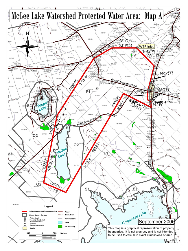
Boundary Description
All that certain lot, piece or parcel of land situated in the vicinity of McGee Lake and Mill Brook, shown outlined in red as the McGee Lake Watershed Protected Water Area on the attached Map "A", and more particularly bounded and described as follows:
Commencing at a point on the northern boundary of the English Mountain Road, near South Alton, Kings County; said point being six hundred and sixty feet westerly from and perpendicular to the center line of Highway Route Number 12 leading from Alton to New Ross;
Thence to run by Astronomic Bearings northerly three thousand three hundred feet along a line six hundred and sixty feet from and parallel to the center line of said Highway Route Number 12;
Thence North forty-two degrees West two thousand nine hundred and seventy feet more or less to the northwest bank of the brook (Mill Brook) out of McGee Lake;
Thence due West two thousand six hundred and forty feet more or less to a point six hundred and sixty feet southeasterly from and perpendicular to the center line of the road leading from Prospect to North Alton;
Thence southwesterly along a line six hundred and sixty feet from and parallel to the center line of said Prospect-North Alton Road to its intersection with the center line of English Mountain Road;
Thence South thirty-eight degrees West seven thousand seven hundred and eighty-eight feet;
Thence South eight degrees thirty minutes West three thousand three hundred feet more or less to the center line of North River Road;
Thence continuing in the same course (S8°30'W) four thousand and ninety-two feet;
Thence South fifty-eight degrees East two thousand seven hundred feet;
Thence North thirty-three degrees East nine thousand six hundred and thirty-six feet to the center line of North River Road;
Thence continuing in the same course (N33°00'E) three thousand four hundred and thirty-two feet, more or less, to a point distant southerly nine hundred and sixty feet from and perpendicular to the center line of English Mountain Road;
Thence South sixty-six degrees thirty minutes East three thousand eight hundred ninety-four feet more or less to the center line of Highway Route 12;
Thence northerly along said center line of said Route 12 seven hundred and ninety-two feet;
Thence westerly at right angles to said center line of Route 12 six hundred and sixty feet;
Thence northerly along a line six hundred and sixty feet from and parallel to said center line nine hundred and twenty feet more or less to the point of commencement.