| This consolidation is unofficial and is for reference only. For the official version of the regulations, consult the original documents on file with the Office of the Registrar of Regulations, or refer to the Royal Gazette Part II. |
| Regulations are amended frequently. Please check the list of Regulations by Act to see if there are any recent amendments to these regulations filed with our office that are not yet included in this consolidation. |
| Although every effort has been made to ensure the accuracy of this electronic version, the Office of the Registrar of Regulations assumes no responsibility for any discrepancies that may have resulted from reformatting. |
| This electronic version is copyright © , Province of Nova Scotia, all rights reserved. It is for your personal use and may not be copied for the purposes of resale in this or any other form. |
O.I.C. 2018-298 (effective December 18, 2018), N.S. Reg. 196/2018
Table of Contents
Please note: this table of contents is provided for convenience of reference and does not form part of the regulations.
Click here to go to the text of the regulations.
Land divisions required for mineral rights and non-mineral registration areas
Base maps used to establish claim reference maps
Division of claim reference map into tracts
Registration in electronic registry
Correction by Registrar of map or document in Registry
Service and Delivery of Documents
Service of notice or document by Minister, Registrar or other person
Delivery of documents to Minister or Registrar
Filing consent obtained for work involving disturbing ground on private lands
Requesting surface access rights
Notice of application to request surface access rights
Access to municipal water supply watershed lands (protected water areas)
Application for exploration licence
Competing applications for common claim
Application for area designated in expired exploration licence
Late renewal of expired licence
Form of certificate of compliance
Refund on refusal or rejection of application
Contents of assessment work report
Work credit amounts for acceptable assessment work
Extension period for filing assessment work
Required work credits for renewing exploration licence
Assessment work acceptable for work credit
Work credits for aerial and ground surveys
Credit for assessment work in excess of minimum
Existing work credit applied to later renewal
Technical Report for Assessment Work
Separate technical report for each exploration licence
Submitting technical report in alternative form of media
Format of technical illustrations
Details of geological work included in technical report
Details of geochemical work included in technical report
Details of geophysical work included in technical report
Details of excavation work performed
Details of metallurgical studies performed
Qualifications required to author technical report
Definition of “community of interest” with licensee
Notification of proposed aerial survey
Drilling programs requirements for licensee—before and after drilling
Excavation Registrations and Letters of Authorization
Submitting excavation registration
Recording excavation registration
Excavation registration struck from records
Application for letter of authorization
Issuing or refusing letter of authorization
Letter of authorization available at work site
Revocation of letter of authorization
Refilling excavation after bulk sampling
Additional prescribed documentation filed with application
Application for non-mineral registration
Additional prescribed documentation to be filed with application
Recording non-mineral registration
Activities Restricted in Areas
Excavating and mining distances from boundary line
Regulation restricting activities in area to be recorded on claim reference maps
Summary of agreement resulting in transfer
Submitting and updating reclamation plans
Information required from lessee or registrant regarding mine closure
Post-production monitoring period
Generally accepted accounting principles
Prohibited reductions to gross income
Information in operator’s records of account
Notice of appeal of assessment of royalties
Annual report for mineral leases and non-mineral registrations
Statistical reports for mining and exploration
Appeals from Officers’ Decisions
Notice of appeal of officer’s decision
Schedule A—Claim Reference Map, Mineral Tract and Claim Divisions
1 These regulations may be cited as the Mineral Resources Regulations.
2 (1) In these regulations, the following definitions apply:
“acceptable” means acceptable to the Registrar in accordance with the regulations;
“Act” means the Mineral Resources Act;
“base map” means a base map as defined in subsection 4(1);
“claim reference map” means a representation of 1/4 of the area of a base map as subdivided in accordance with subsection 5(1);
“drill core” means a cylindrical core of material removed from a drill hole;
“drill hole” means a hole that is drilled to a depth of at least 1 metre for the primary purpose of obtaining geological, geochemical or geophysical information;
“drilling program” means drilling activity conducted on a claim area or areas during a period that is measured from when drilling begins to the removal of the final drill machine, or to a time as extended by the Registrar;
“electronic registry” means the Province’s online mineral resources registration system maintained by the Registrar as required by subsection 15(2) of the Act that provides Internet browser-based access to mineral tenure information and electronic access for applying for mineral rights and maintaining existing mineral rights;
“engineer” means a person holding a licence to practise under the Engineering Profession Act or, for a person who is not resident in the Province, equivalent legislation in the jurisdiction in which the person is resident;
“file” means to file through the electronic registry;
“geoscientist” means a person holding a license to practice [licence to practise] under the Geoscience Profession Act;
“index map” means a generalized location map;
“mineral reserve” means the economically mineable part of a mineral resource;
“overburden” means the layer of soil, gravel, rock or other material covering a layer of bedrock;
“reclamation plan” means a reclamation plan required for a mineral lease or non-mineral registration under Section 86 of the Act;
“reclamation security” means the security required under Section 88 of the Act to be provided for the reclamation of the area that may be disturbed by the activities of a licensee, lessee, registrant or holder of a letter of authorization or excavation registration, or their agent or assignee;
“seal”, in relation to a drill hole, means to close off all or any part of the length of a drill hole in a permanent manner to ensure the prevention of leakage by appropriate methods and materials that meet industry standards;
“technical illustration” means a depiction of data that clarifies the content of a report or stands alone as a record of information and includes a map, plan, section, drawing, chart, graph, diagram or photograph;
“tract” means subdivision of a claim in accordance with Section 6;
“watercourse” means the bed or shore of any river, stream, lake, creek, pond, spring, lagoon or ocean, and the water therein, within the jurisdiction of the Province, whether it contains water or not.
(2) In the Act and these regulations, the following definitions apply:
“mineral resource” means a concentration or occurrence of a mineral found in or on the earth’s crust in a form and quantity and grade or quality that indicate reasonable prospects for economic extraction;
“stakeholders” means the individuals, groups, communities, organizations, associations or authorities whose interests may be positively or negatively affected by a proposal or activity under the Act and who are concerned with the proposal or activity and its consequences;
“underground exploration” means opening or reopening underground workings and includes dewatering or rehabilitating the workings.
(3) The following definitions apply in the Act:
“confidential information” in subsection 141(3) of the Act means information referred to in Section 21 of the Freedom of Information and Protection of Privacy Act;
“construction stone” in the definition of “mineral” in clause 3(v) of the Act includes shale or clay when used to manufacture common building bricks;
“privileged” in Section 135 of the Act means, in relation to information, that the information is confidential information.
Land divisions required for mineral rights and non-mineral registration areas
3 All mineral rights and non-mineral registration areas must be defined or described in terms of the divisions of land set out in Sections 4 to 8.
Base maps used to establish claim reference maps
4 (1) In these regulations, “base map” means a National Topographic System (NTS-NAD 83) map on a scale of 1:50 000 produced by the federal Department of Natural Resources for areas bounded by each 30' of longitude and each 15' of latitude.
(2) Base maps must be used for establishing claim reference maps to determine the boundaries of claims, licences, leases and non-mineral registrations.
5 (1) Each base map must be subdivided into claim reference maps, as shown in Figure 1 of Schedule A, by median lines corresponding to the median longitude and latitude lines of the base map, with the resulting claim reference maps lettered A for the southeast quarter, B for the southwest quarter, C for the northwest quarter and D for the northeast quarter.
(2) Each claim reference map must be identified by the numbering of the base map of origin and the appropriate quarter section letter.
(3) Claim reference maps maintained by the Registrar are conclusive as to the matters shown on them and are the sole official depiction of the relative location and extent of mineral rights and non-mineral registrations.
Division of claim reference map into tracts
6 (1) Each claim reference map must be subdivided into 108 tracts by 12 equal divisions on latitude and 9 equal divisions on longitude, as shown in Figure 2 in Schedule A, in accordance with all of the following specifications:
(a) the east and west boundaries of each tract must be true meridians of longitude;
(b) the north and south boundaries of each tract must be straight lines parallel to the chord of 1/2 of the part of the parallel of latitude that represents the south boundary of each claim reference map;
(c) the angle of intersection of each chord on either side of the median meridian of longitude for each claim reference map must be 90°.
(2) Each tract must contain 259 ha, more or less.
(3) The 108 tracts on a claim reference map must be numbered as shown in Figure 2 in Schedule A.
7 (1) Each tract on a claim reference map must be subdivided into 16 claims, by 4 equal divisions on latitude and 4 equal divisions on longitude.
(2) The 16 claims in each tract of a claim reference map must be lettered as shown in Figure 3 in Schedule A.
8 (1) All boundaries extend downward vertically without limit.
(2) All surface measurements must be referenced to a horizontal plane.
Registration in electronic registry
9 A person who wishes to prospect or explore must register as a user of the electronic registry in order to file documents with the Registrar.
Correction by Registrar of map or document in Registry
10 When the Registrar becomes aware of an error on a map or document maintained by the Registrar, whether in electronic or paper form, the Registrar must correct the error.
Service and Delivery of Documents
Service of notice or document by Minister, Registrar or other person
11 (1) In addition to service by prepaid registered mail to a person’s address under subsection 34(2) of the Act, a notice or other document that is served under the Act or these regulations by the Minister, Registrar or any other person acting under the authority of the Act or these regulations is deemed to be effectively served on a person if delivered by any of the following methods:
(a) it is delivered personally;
(b) it is sent through the electronic registry;
(c) it is sent by e-mail to the most recent e-mail address for the person in the Registrar’s records.
(2) A notice or document referred to in subsection (1) is deemed to have been received no later than the 7th day after the date of service.
(3) The Registrar may order another means of service, including substituted service or service by advertisement.
Delivery of documents to Minister or Registrar
12 (1) A document required to be delivered to the Minister under the Act or these regulations must be delivered by 1 of the following methods:
(a) personal delivery;
(b) registered mail.
(2) A document required to be delivered to the Registrar under the Act or these regulations must be delivered by 1 of the following methods:
(a) personal delivery;
(b) registered mail;
(c) filing electronically, as required by these regulations and subsection 17(2) of the Act.
(3) A document is not received by the Minister or Registrar until it is delivered in accordance with subsection (1) or (2).
Filing consent obtained for work involving disturbing ground on private lands
13 When consent is obtained from a private land owner or occupier for activities that involve disturbing the ground under subsection 25(3) of the Act, the written consent required by that subsection must be filed by the mineral right holder, and must include all of the following:
(a) the name and mailing address of the owner or current occupier;
(b) the name and address of the mineral right holder;
(c) a description of the work;
(d) a description of the property;
(e) a statement signifying the owner or occupier’s written consent to the work done;
(f) the signatures of the mineral right holder and the owner or occupier.
Requesting surface access rights
14 An application to the Minister under Section 26 of the Act to request surface access rights by a mineral right holder must be in the form of a statutory declaration submitted to the Minister and contain all of the following:
(a) for a mineral right holder who is unable to obtain consent to enter upon private land from the land owner or occupier:
(i) the name of the mineral right holder, the mineral right and any exploration licence number,
(ii) the name of the owner or current occupier,
(iii) the location of the property, with map,
(iv) the activities that involve disturbing the ground,
(v) details of the contact made with the owner or occupier for the purposes of obtaining consent;
(b) for a mineral right holder who is unable to contact or locate the land owner or occupier to obtain consent to enter upon private land:
(i) the particulars of the title search of the private land,
(ii) the efforts taken to locate the owner or occupier,
(iii) details of the attempts made to contact the owner or occupier for the purposes of obtaining consent.
Notice of application to request surface access rights
15 (1) The Minister must provide the owner or occupier of the land with a written notice of an application made under Section 14, stating all of the following:
(a) that a request for surface rights access to the owner’s or occupier’s land has been made;
(b) that, no later than 30 days after the date of the notice, the owner or occupier may do either of the following, in writing:
(i) consent to access for the mineral right holder,
(ii) state why no consent should be given.
(2) The Minister may request further information from a mineral right holder or an owner or occupier concerning an application under Section 14, and the mineral right holder or owner or occupier has 14 days to respond to the Minister.
Access to municipal water supply watershed lands (protected water areas)
16 (1) In this Section, the following definitions apply:
“exploration with ground disturbance” means any of the activities listed in subsection 25(3) of the Act;
“preliminary exploration” means exploration with no ground disturbance, including all activities listed in subsection 25(2) of the Act, but does not include seismic surveys in which explosives are used;
“protected water area” means a protected water area under Section 106 of the Environment Act, as shown on a claims reference map.
(2) In addition to any requirement to obtain consent from persons under Section 24 or 25 of the Act, before beginning any preliminary exploration in a protected water area, a person must give the operator of the water works a written notice of the exploration that includes all of the following, and file a copy of the notice with the Registrar:
(a) the proposed exploration activities;
(b) the dates that the exploration will begin and end.
17 (1) To register as a prospector under clause 30(2)(a) of the Act, a person must file an application with the Registrar that contains all of the following:
(a) the applicant’s name, address and telephone number;
(b) the fee, in accordance with the fees set out in Section 79;
(c) the signature of the applicant.
(2) The Registrar must maintain a list of registered prospectors that includes all of the particulars of each registered prospector who applies under subsection (1).
(3) The Registrar must advise each registered prospector of where they may access a copy of the Act and these regulations.
(4) The Registrar must issue an identification card to each registered prospector through the electronic registry that contains all of the following:
(a) a registration number;
(b) an acknowledgment that the holder of the identification card is a registered prospector.
(5) A prospector’s registration under this Section is for a term of 10 years, and may be renewed by updating and confirming the particulars of the prospector’s registration provided under subsection (1).
Application for exploration licence
18 An application for an exploration licence under subsection 31(1) of the Act, or its renewal under Section 47 of the Act, must be made by filing an application with the Registrar that contains all of the following information, in addition to the information required by subsection 34(1) of the Act:
(a) the minerals subject to the exploration licence;
(b) the area and location of the minerals;
(c) a description of the claim, the tracts and the claim reference map;
(d) the applicant’s name and occupation.
Competing applications for common claim
19 (1) The notice required to be given by the Registrar under subsection 32(1) of the Act to multiple applicants for a common claim must be in writing sent no later than 7 days after the date of application, and include all of the following:
(a) notice of any other pending applications received by the Registrar;
(b) a request that the applicant submit tenders or proposals in accordance with subsection (2).
(2) Tenders or proposals for the right to obtain an exploration licence must outline the proposed assessment work and be received no later than 30 days after the date the notice is sent under subsection (1).
Application for area designated in expired exploration licence
20 An application for an exploration licence for all or a portion of the same area designated in an expired exploration licence may not be made before 10 a.m. on the day following the expiry date of the expired licence.
21 (1) An exploration licence is issued through the electronic registry.
(2) In addition to the information required by Section 39 of the Act, all of the following is prescribed as information that must be included on an exploration licence under Section 39 of the Act:
(a) the name of the licensee;
(b) the name of the minerals subject to the licence;
(c) any conditions on the licence, as determined by the Registrar;
(d) the unique number assigned to the licence.
Late renewal of expired licence
22 (1) The renewal of a licence under Section 50 of the Act does not alter the anniversary date of the licence or the required assessment work for the licence.
(2) The time within which an expired exploration licence may be renewed under Section 50 of the Act is no later than 90 days after the date the licence expires.
Form of certificate of compliance
23 A certificate of compliance granted under Section 52 of the Act is issued through the electronic registry and must contain all of the following information:
(a) the licensee’s name;
(b) the exploration licence number;
(c) an acknowledgment of compliance with either required assessment work or payment of fees in lieu of the work;
(d) the renewal date of the licence;
(e) the expiry date of the licence;
(f) the number of cumulative terms of the licence upon renewal;
(g) a summary, expressed in dollar amounts, of all of the following:
(i) work submitted,
(ii) work required,
(iii) credits acquired,
(iv) credits remaining,
(v) payment in lieu of work,
(vi) total credits used,
(vii) total credits available,
(viii) total credits remaining.
Refund on refusal or rejection of application
24 A refund of fees made under Section 41 of the Act when an application for an exploration licence is refused or rejected may be made to the applicant by 1 of the following methods:
(a) by registered mail to the address provided in the application;
(b) by electronically crediting the amount back to the applicant.
25 (1) A stakeholder engagement plan prepared and implemented by a licensee under Section 44 of the Act must
(a) include the time period before and during the exploration and development of mineral resources;
(b) be proportionate to the nature and location of the licensed area;
(c) be revised throughout the course of work on the licensed area whenever there are changes to the scope of the work; and
(d) be filed, if requested by the Minister.
(2) A stakeholder engagement plan filed under clause (1)(d) must be filed no later than 24 hours after the Minister’s request, and must be acceptable to the Registrar.
26 (1) A statement of expenditure required to be submitted by a licensee under subsection 45(1) of the Act must be submitted by filing a statement with the Registrar that contains all of the following information:
(a) the licensee’s name and mailing address;
(b) the exploration licence number;
(c) the date the exploration licence was issued;
(d) the type and amount of work done or caused to be done;
(e) the amount spent;
(f) the overhead costs;
(g) the name and mailing address of each person who complected the work and the dates that they worked;
(h) a certification by the licensee as to the truth and correctness of the statement of expenditure.
(2) All expenditures for assessment work that qualifies for work credit must be expressed in Canadian dollars on a statement of expenditure and must be documented to the satisfaction of the Registrar.
(3) Receipts or proof of expenditures must be provided to the Registrar on request.
Contents of assessment work report
27 (1) In addition to the information required for a statement of expenditure in subsection 26(1), assessment work submitted for credit for an exploration licence must include 1 of the following:
(a) a prospector’s statement filed with the Registrar, and acceptable to the Registrar, that contains all of the following:
(i) the exploration licence number,
(ii) the date the exploration licence was issued,
(iii) the general location of the property,
(iv) the claims, tracts and claim reference map for the area licensed under the exploration licence,
(v) the results of the exploration,
(vi) samples taken and analysed,
(vii) other significant observations,
(viii) the total cost of the work,
(ix) certification by the licensee as to the accuracy of the information provided;
(b) a technical report, as set out in Sections 35 to 46.
(2) A prospector’s statement filed under clause (1)(a) must be accompanied by a daily log of activities and a map upon which relevant new observations are noted.
(3) A prospector’s statement may be submitted for work credit only for the first 2 renewals.
(4) A technical report with any engineering content must be prepared by an engineer.
Work credit amounts for acceptable assessment work
28 Acceptable assessment work under Section 31 submitted for work credit under Section 27 in respect of an exploration licence must be credited by the Registrar at the amount set out in the following table for each 8-hour day, per person, during which the assessment work was performed:
How Submitted |
Amount Credited per Person per 8-hour Day |
prospector’s statement |
$130.00 |
technical report |
for work performed by person who is an engineer or geoscientist, the full invoiced cost |
for work performed by anyone other than an engineer or geoscientist, $250.00 |
Extension period for filing assessment work
29 The period for which the Registrar may grant a licensee a single extension under subsection 48(1) of the Act for filing assessment work is up to 45 days.
Required work credits for renewing exploration licence
30 The dollar value of work credit given for assessment work that is required for renewing an exploration licence is based on the number of terms for which the licence has been issued and consecutively renewed, as set out in the following table:
Number of Terms for Which Licence Issued/Renewed |
Dollars per Term per Claim |
1 to 2 (licence age 0-4 years) |
$400 |
3 to 5 (licence age 5-10 years) |
$600 |
6 to 8 (licence age 11-16 years) |
$800 |
9 and any subsequent renewal term (licence age 17 years and older) |
$1600 |
Assessment work acceptable for work credit
31 (1) The following is acceptable assessment work and may be credited as work credit at the full cost of the work:
(a) prospecting;
(b) trenching, pitting, stripping, bulk sampling and refilling excavations;
(c) line cutting or flagging;
(d) all of the following surveys, except as provided in Section 32:
(i) geological surveys,
(ii) geochemical surveys,
(iii) geophysical surveys, including ground, marine and borehole investigations,
(iv) aerial surveys, including photographic and geophysical;
(e) photogeological and remote imagery interpretations;
(f) drilling and sealing of drill holes;
(g) ground surveys related to exploration or development;
(h) ground exploration work;
(i) assays, analyses, metallurgical studies and mineral tests;
(j) technical data compilations;
(k) any work and reasonable expenditures approved by the Registrar as being necessarily incidental to and directly associated with the work referred to in clauses (a) to (j), including expenses for accommodation, food, meals and transportation;
(l) reclamation work;
(m) drafting and cartographic services.
(2) The cost of the following assessment work is an allowable expense, if the cost of the work is considered reasonable by the Registrar as being necessarily incidental to and directly associated with the work, and the total work credit given for the assessment work performed must not exceed 50% of the total cost of assessment work credited under subsection (1) in respect of an exploration licence:
(a) negotiations with landowners for surface access;
(b) legal fees related to land access or land ownership;
(c) compensation for landowners;
(d) direct costs of stakeholder engagement.
(3) The following costs for assessment work are allowable expenses, and the total work credit given for the assessment work performed must not exceed 10% of the total cost of assessment work credited under subsection (1) in respect of an exploration licence:
(a) the cost of buildings, structures, machinery, plants, equipment, conveyances or access roads;
(b) the cost of site rehabilitation;
(c) expenditures made to do any of the following:
(i) prepare environmental impact or assessment studies conducted for proposed mining purposes,
(ii) test mining methods,
(iii) prepare metallurgical study reports, including expenditures for consumable items related to ore processing test work, pilot plant runs and milling of bulk samples;
(d) the cost of preparing marketing studies;
(e) accounting fees directly attributable to the licence;
(f) the cost of administrative support services;
(g) the cost of field supplies;
(h) office expenses for any of the following:
(i) rent,
(ii) heat,
(iii) light,
(iv) supplies,
(v) telecommunications,
(vi) office equipment rental,
(vii) postage, express and freight,
(viii) building and equipment insurance,
(ix) reasonable printing and copying charges directly attributable to the licence.
(4) Despite subsections (1), (2) and (3), assessment work must not be credited as work credit if any of the following apply:
(a) the work has been previously credited;
(b) the work fails to provide new or additional data contributing to the geoscientific knowledge of the area where it was conducted;
(c) the work is not directly related to seeking landowner permission or stakeholder engagement for exploration;
(d) the work is not reported in the manner prescribed by these regulations;
(e) the work is not considered acceptable.
Work credits for aerial and ground surveys
32 (1) Work credit given for aerial surveys is credited as a percentage of costs of the survey, based on the time that has elapsed between the completion of the survey and submission of an acceptable work report and statement of expenditure in accordance with these regulations, as set out in the following table:
Time Report Submitted (years after survey completed) |
Percentage of Survey Cost Credited |
1st renewal after survey (up to 2 years after survey) |
125% |
2nd renewal after survey (years 3 and 4 after survey) |
100% |
3rd renewal after survey (years 5 and 6 after survey) |
75% |
4th and 5th renewal after survey (years 7, 8, 9 and 10 after survey) |
at the discretion of the Registrar, to a maximum of 50% |
6th or subsequent renewal after survey (beyond 10 years after the survey) |
0% |
(2) Work credit for prospecting or preliminary ground surveys performed on an unlicensed area is credited in respect of an exploration licence that is subsequently acquired for the survey area if all of the following conditions are met:
(a) the prospector is in compliance with Section 30 of the Act;
(b) the assessment work was conducted on lands that were, at the time of the work, available for application for an exploration licence;
(c) an assessment work report and statement of expenditure are submitted.
(3) Work credit allowed under subsection (2) is credited in the same manner as for aerial surveys under subsection (1), except that it is based on the time that elapses between the date the work begins and the date that the reports and statements required by Section 45 of the Act are submitted.
Credit for assessment work in excess of minimum
33 Work credit in excess of the value specified in Section 30 that is required to be applied by the Registrar under subsection 51(1) of the Act against the assessment work requirement for subsequent renewals of an exploration licence must be applied at its full value for credit up to a maximum of 10 years following the date the work is submitted for credit, if the work is submitted
(a) after the effective date of these regulations; and
(b) in the licence year during which it was conducted.
Existing work credit applied to later renewal
34 (1) Excess assessment work recorded by the Department to the credit of an exploration licence issued under the former Act and applied under Section 161 of the Act to the assessment work requirements of an exploration licence issued or renewed under the Act may be brought forward up to a maximum of 10 years from the date the work was originally submitted for credit after the effective date of these regulations for a later application to renew the licence and must be applied in accordance with Section 32 as of the next anniversary date of the licence after the effective date.
(2) For the purposes of subsection (1), any work credits that will reach the 10-year maximum in the middle of an exploration licence’s term must be extended to the end of the licence term.
Technical Report for Assessment Work
Separate technical report for each exploration licence
35 A separate technical report must be filed for each exploration licence unless
(a) an exploration licence forms part of a group of coterminous exploration licences, in which case a single technical report for the group is acceptable; or
(b) the technical report is approved by the Registrar for assessment work to be applied as work credit to more than 1 exploration licence.
Submitting technical report in alternative form of media
36 (1) The Registrar may accept a technical report that exceeds a size acceptable to the electronic registry in an alternative form of media acceptable to the Registrar labelled on the exterior as a technical report and in accordance with subsection (2).
(2) Submission of a technical report must include all of the following:
(a) a label identifying the report as a technical report;
(b) a list of all applicable exploration licence numbers;
(c) the name of each mineral rights holder;
(d) a text file listing the contents of the submission;
(e) all data files applicable to the report.
37 (1) A technical report must be made up of text together with any combination of maps, figures, illustrations, photographs and analyses.
(2) A technical report must meet all of the following criteria:
(a) be capable of being printed on paper of letter or legal size, while maintaining the format of the original electronic document;
(b) have margins of suitable width to allow full view of the contents of each page;
(c) have a title page, with all subsequent pages numbered consecutively;
(d) display the date on which the report was completed;
(e) include detailed tables, as follows:
(i) table of contents that sets out the principal subdivisions of the text with corresponding page numbers,
(ii) table of illustrations with corresponding figure numbers,
(iii) table of appendices with corresponding appendix numbers,
(iv) list of tables with corresponding table numbers and titles, and
(v) list of data files that apply to the report;
(f) be in a single portable document format (PDF) file with text, maps, figures and illustrations either
(i) converted directly to PDF, or
(ii) if direct conversion to PDF is not possible, scanned at 300 dots per inch and then converted to PDF.
(3) Each of the data files that apply to a technical report must be in a format other than PDF that is acceptable to the Registrar.
38 (1) A technical report must contain all information obtained from technical data compilations and assessment work conducted and submitted for assessment work credits under Sections 40 to 46.
(2) The text of each technical report must include all of the following principal subdivisions:
(a) a summary—to include a summary of the work performed and of the results obtained;
(b) an introduction—to include an outline of the scope of and reasons for the work;
(c) location and access—to include an outline of details regarding the location of the work;
(d) exploration licence tabulation—to include a tabulation of the exploration licences pertaining to the technical report, including all of the following:
(i) claim reference maps, tracts, claims and dates of issue,
(ii) the name of the licence holder,
(iii) the name of the person submitting the technical report, if different from the licence holder;
(e) work performed—to include a detailed description of the assessment work conducted including the names of the persons who conducted the work and the dates during which the work was performed;
(f) interpretation of results—to include a discussion and interpretation of the results of the work conducted;
(g) conclusions and recommendations—to include an outline of the conclusions reached and recommendations made regarding future work on the property under the licence;
(h) a bibliography;
(i) an author’s certificate, as required by subsection 46(2);
(j) appendices;
(k) a list of any data files that apply to the report, along with a description of the content and format.
(3) A technical report that includes assays or analytical results must include all of the following:
(a) a description of the analytical methods and indicated detection limits and analytical uncertainties;
(b) a description of quality assurance and quality control procedures and analyses of any control samples;
(c) a legible and signed copy of the certified laboratory report submitted by the analytical facility that conducted the work.
Format of technical illustrations
39 (1) A technical illustration that accompanies or is included in a technical report must be in a format acceptable to the Registrar and meet all of the following criteria:
(a) it is produced at a scale that is appropriate to the information being illustrated, and in sufficient detail to permit on-site verification;
(b) it is clearly visible and legible;
(c) it includes a complete legend referenced by numbers, letters, graphic patterns or symbols;
(d) it includes all of the following, as appropriate to the nature of the illustration, including any separate index map:
(i) a bar scale,
(ii) an astronomic (true) north arrow,
(iii) at least 3 Universal Transverse Mercator (UTM) map coordinates referred to the North American Datum of 1983 (NAD 83) in accordance with the National Topographic System (NTS),
(iv) a title,
(v) the date the illustration was prepared,
(vi) a figure number.
(2) A technical illustration that includes a map, other than an index map, must include all of the following:
(a) the plotted location of appropriate Universal Transverse Mercator (UTM) grid lines referred to the North American Datum of 1983 (NAD 83) in accordance with the National Topographic System (NTS);
(b) the exploration licence boundaries along with appropriate tract or claim boundaries;
(c) distinctive topographic features illustrated in such manner that they can be readily identified and located on the ground;
(d) the location of all surface or underground workings;
(e) the location of all surveyed lines and grid lines, named or identified appropriately, with the length and azimuth of each line shown;
(f) the location of any geodetic monuments, survey control points, bench marks and reference measurements relative to identifiable surface features or permanent objects.
Details of geological work included in technical report
40 A technical report that includes geological work as assessment work submitted for work credit must include all of the following:
(a) a report of geological work that includes descriptions of all of the following:
(i) the manner in which the work was conducted, the dates upon which it was conducted and by whom it was conducted,
(ii) the geological features observed,
(iii) the synthesis of the geological observations referred to in subclause (ii),
(iv) each sample taken and the location of each sample taken,
(v) all prospecting activity conducted;
(b) a geological map that shows all of the following:
(i) mapped outcrops, float and other observed geological features,
(ii) the orientation of geological features observed,
(iii) identification of the various rock types observed,
(iv) trenches, pits, stripped areas, shafts and underground workings,
(v) the number and location of all drill holes,
(vi) the location and identification, by means of sample number, of all samples taken for analysis,
(vii) an indication of the detection limit of the analytical procedures employed,
(viii) the numerical values of all analysed rock above the detection limit for the elements that form the primary targets of the exploration program.
Details of geochemical work included in technical report
41 A technical report that includes geochemical work as assessment work submitted for work credit must include all of the following:
(a) a report of geochemical work, including an orientation survey, that includes all of the following:
(i) the type of survey, including a description of sample medium and field sample preparation,
(ii) the size fractions analysed and details of laboratory preparation including crushing and splitting methodology,
(iii) relevant site information not already contained in a separate part of the report that may have a bearing on the results obtained and their interpretation, including all of the following:
(A) local geology,
(B) local topography,
(C) local surface and ground water data,
(D) local meteorological conditions,
(E) specific dates of when work is done,
(iv) a description of results;
(b) a geochemical map that shows all of the following:
(i) the distinctive topographic features and relevant site information that may influence the interpretation of results,
(ii) the location and identification, by means of sample number, of all samples taken for analysis,
(iii) an indication of the detection limit and analytical uncertainty of the analytical procedures employed,
(iv) the numerical values above the detection limit for the elements that form the primary targets of the exploration program.
Details of geophysical work included in technical report
42 (1) A technical report that includes geophysical work as assessment work submitted for work credit must include all of the following:
(a) a report of geophysical work, including an orientation survey, that includes all of the following:
(i) the type and method of survey, correctional techniques, type and model of instrument used, components measured and locational controls employed, including the following:
(A) for a ground survey, the total line kilometres surveyed and line spacing,
(B) for an aerial survey, the aircraft type, ground clearance, location of area covered and total line kilometres surveyed and line spacing, and
(C) for a shipborne survey, the type and size of vessel and total line kilometres surveyed and line spacing,
(ii) relevant information that may have a bearing on the results obtained and their interpretation, including local geology, topography, powerlines, swamps and meteorological conditions,
(iii) a description of results;
(b) a geophysical map that shows all of the following:
(i) distinctive topographic features and relevant site information that may have a bearing on the interpretation of results,
(ii) applicable instrument and transmitting station orientation,
(iii) instrument readings for each station or fix point, corrected for instrument drift and diurnal variations,
(iv) properly supported, contoured or profiled information from any airborne, shipborne or remote sensing surveys conducted.
(2) A geophysical profile or cross-section that is submitted as part of geophysical work under this Section must show all of the following:
(a) horizontal and vertical scales;
(b) stations identified so that the profile or cross-section may be related to the tract, traverse or drill hole and geophysical survey maps.
43 (1) A technical report on assessment work that includes drilling activity, other than drilling performed for blasting purposes, must include a drilling results report that includes all of the following:
(a) a written description of the drilling program, including all of the following:
(i) type of drilling,
(ii) number of drill holes,
(iii) dates the drill program began and ended,
(iv) drill core storage site,
(v) drill hole abandonment procedures;
(b) drill hole information for each drill hole including,
(i) location,
(ii) size,
(iii) length,
(iv) equipment and casing left in the drill hole;
(c) an identification of drill targets;
(d) a review of the results of the drilling program;
(e) a description of drill hole geophysical surveys, including results;
(f) an identification of the type of material sampled including core, sludge, overburden and chips and sample fraction including whole core and split core;
(g) a typed drill log for each drill hole that includes all of the following:
(i) the name of the exploration company,
(ii) the name of the licensee, if not the same as reported under subclause (i),
(iii) the hole identification number, which includes a year designation,
(iv) the collar location with map coordinates, exploration grid coordinates and claim reference map, tract and claim references,
(v) the datum, whether established or assumed,
(vi) the azimuth, inclination and elevation of the drill hole at the collar,
(vii) the depth and result of each dip and azimuth test,
(viii) the depth of overburden and the total depth of the drill hole,
(ix) the dates that the drilling began and ended,
(x) the type of materials obtained, including core, chips and sludge,
(xi) the name of the drilling contractors,
(xii) the drill hole size,
(xiii) the name of the person who prepared the drill log,
(xiv) a detailed geological description in descending order from the collar to the end of the hole, including depths of features described, sample numbers and sample intervals,
(xv) if possible, all assays, analyses and results,
(xvi) a statement regarding whether whole or split samples were removed.
(2) Technical illustrations submitted for drilling work must be in the form of maps that record the location of drill holes and show drill hole number and relevant site information.
Details of excavation work performed
44 (1) A technical report on assessment work that includes excavation work, must include an excavation results report that includes all of the following:
(a) a description of the following:
(i) the location of workings, together with, if applicable, an exploration grid reference,
(ii) the type of excavation including trenching, pitting, stripping, bulk sampling, shaft sinking, driving adits, declines, drifts, cross-cuts, levels, raises and winzes, and the re-opening, rehabilitation or dewatering of any working,
(iii) the method and equipment used,
(iv) the dimension and orientation of workings and, where the depth of the overburden is known, the depth of overburden;
(b) the purpose of the excavation;
(c) the excavation registration number or date of the letter of authorization;
(d) the dates the excavation work began and ended;
(e) a description and location of all samples taken, and analysed, and the name of the laboratory where samples were analysed.
(2) A technical illustration submitted for an excavation must show all of the following that are applicable to the excavation:
(a) the location of the excavation with respect to appropriate tract or claim boundaries;
(b) the dimensions and orientation of the excavation;
(c) the location and identification, by means of sample number, of all samples taken for analysis;
(d) an indication of the analytical uncertainty detection limit of the analytical procedures employed;
(e) the numerical values above the detection limit for the elements that form the primary targets of the exploration program;
(f) a description of reclamation work carried out;
(g) a figure or drawing identifying the area reclaimed.
Details of metallurgical studies performed
45 A technical report on assessment work that includes metallurgical studies or test work or mineralogical examinations must include a report on the results of the studies, test work and examinations that includes all of the following:
(a) the source, including location if possible, quantity and type of all samples collected;
(b) the quantity and size fractions of the samples used for testing;
(c) the mineralogical composition of the samples, if it has been determined;
(d) the results of all methods of processing performed or investigated;
(e) a process flowsheet and metallurgical results from pilot plant testing and bulk sample processing.
Qualifications required to author technical report
46 (1) A technical report required to be made under the Act or regulations, other than a statistical report, must be prepared by 1 of the following:
(a) a geologist;
(b) a geophysicist;
(c) a geochemist;
(d) a mining or geological engineer;
(e) a person with acceptable experience or qualifications.
(2) A technical report must be filed with the author’s certificate attached, and both the technical report and certificate must be dated and signed.
(3) An author’s certificate referred to in subsection (2) must state all of the following:
(a) the author’s name, address and occupation;
(b) the author’s qualifications, including the author’s work experience;
(c) whether the report is based on a personal examination by the author;
(d) the date of any personal examination;
(e) if the report is not based on a personal examination by the author, the source of the information contained in the report;
(f) the particulars of any securities of the company, or its affiliates, that the author owns;
(g) whether the author has, directly or indirectly, received or expects to receive any interest, direct or indirect, in the property of the company the report was made for or any of its affiliates, or beneficially owns, directly or indirectly, any securities of the company or any of its affiliates and, if so, give particulars;
(h) whether the author is a geoscientist or an engineer.
47 (1) If an exploration licence is renewed before the expiry date of the exploration licence,
(a) there is no refund of all or any portion of the application fees paid;
(b) work credits that have been accepted in accordance with Section 31 are not redistributed until the next renewal of the licence;
(c) despite Section 31, if additional assessment work is submitted before the next renewal, the assessment work must be added to existing work credits at the following percentages, or as otherwise specified in Section 32:
(i) 100% of acceptable cost, if filed in the exploration licence term during which the work was performed,
(ii) 50% of acceptable cost, if filed past the exploration licence term.
(2) The manner for contacting the Registrar under subsection 43(4) of the Act to notify of the applicant’s intent to renew an exploration licence when the electronic registry is unavailable due to system outages, must be by 1 of the following methods no later than 08:00 a.m. of the next calendar day:
(a) telephone;
(b) e-mail.
Definition of “community of interest” with licensee
48 For the purposes of the prohibition on renewing an exploration licence in Section 49 of the Act, a “community of interest” with a licensee includes any of the following:
(a) a corporation and a person or 1 of several persons who directly or indirectly control the corporation;
(b) unrelated corporations that are controlled directly or indirectly by the same persons;
(c) persons connected by blood relationships, marriage or by adoption;
(d) persons connected within a partnership;
(e) persons engaged in a joint venture.
Notification of proposed aerial survey
49 Before conducting an aerial survey, the person conducting the survey or the licensee must provide the Registrar with at least 7 days’ notice by filing a notice of the proposed aerial survey with the Registrar containing all of the following:
(a) the exploration licence number for the area being surveyed;
(b) the aerial contractor’s name, address and contact information;
(c) aerial survey details.
Drilling programs requirements for licensee—before and after drilling
50 (1) No later than 7 days before beginning drilling, a licensee must file a drilling notification with the Registrar.
(2) No later than 30 days after the date that a drilling program is completed, a licensee must do all of the following:
(a) provide the Registrar with a tabulation of drill hole data, including grid references, azimuths, dips, total depths, dates drilling began and ended and a drill hole location map cross-referenced to claim or licence boundaries;
(b) permanently seal each drill hole from a minimum depth of 3 m in competent bedrock back to the surface of the ground, unless
(i) the owner or occupier requests that the drill hole not be sealed, or
(ii) the accepted reclamation plan indicates further work is to be conducted following completion of the drilling program;
(c) seal all significant intersections in a drill hole where water, coal, salt, potash, uranium or petroleum, as defined in the Petroleum Resources Act, have been encountered;
(d) remove all debris, including abandoned rods and casings, from the area and leave the drill site with no casing or pipe protruding above the surface of the ground.
(3) Drill holes drilled for the sole purpose of sampling overburden or the overburden and bedrock interface are not required to be sealed in accordance with clause (2)(b).
(4) The Registrar may grant a single extension of time for a licensee to comply with clause (2)(a), if the licensee shows good cause, in writing, for the extension.
51 (1) In this Section,
“holder” means the person who is in possession of a drill core.
(2) A holder of drill core obtained for the purpose of mineral exploration must do all of the following:
(a) retain the drill core in a standard core box at the drill site or at a drill core storage facility;
(b) take precautions to secure the drill core against weather and vandalism;
(c) request permission of the Registrar before removing the drill core from the Province.
(3) A person must not discard, destroy or otherwise reduce the scientific value of a drill core without first requesting and obtaining the Registrar’s permission to do so, unless the person is using the drill core for assaying, testing or beneficiation or metallurgical, mineralogical or other scientific studies.
(4) If the Registrar is of the opinion that the scientific value of a drill core is significant, the Registrar may direct an officer to take possession of the drill core for the Minister and take any other action the Registrar considers necessary to preserve the drill core.
(5) Before a drill core is received by the Registrar under subsection (4), the holders of the drill core must identify each core box with a weatherproof label that indicates all of the following:
(a) the drill hole number;
(b) the core interval represented;
(c) the date that it was drilled;
(d) the name of the company the drill core was drilled for.
Excavation Registrations and Letters of Authorization
Submitting excavation registration
52 (1) An excavation registration must be entered into the electronic registry and must contain all of the following:
(a) the licensee’s name and exploration licence number;
(b) a description of the excavation work to be carried out;
(c) the location, including the claim, the tracts and claim reference map where the excavation will be carried out;
(d) written confirmation that the written consent of the owner or occupier of private lands as required by Section 25 of the Act was obtained, or a copy of the Ministerial grant of surface access rights under Section 26 of the Act;
(e) a sketch map of a practical scale showing the extent of the proposed work and sufficient topographical detail to permit the work to be easily located;
(f) if the work is not being conducted by the licensee, the telephone number of the licensee’s field representative of the person who is conducting the work;
(g) the date that the work is scheduled to commence and the date it is scheduled to be completed;
(h) the expected date that reclamation will be completed;
(i) a certification as to the truth and correctness of the information;
(j) agreement to be bound by any conditions required by the Registrar and to have the registration posted on the electronic registry.
(2) An excavation registration submitted before commencing work, as required by Section 61 of the Act, must be submitted at least 7 days before the work is commenced.
(3) An excavation registration is not required to be submitted for bulk sampling that ends up being less than 100 tonnes if the licensee has received a letter of authorization for the sampling.
Recording excavation registration
53 (1) The Registrar may refuse to record an excavation registration, and must inform the licensee of the refusal, if the Registrar determines that the information submitted under Section 52
(a) is incomplete; or
(b) was not submitted by the deadline in subsection 52(2).
(2) The Registrar must enter an excavation registration in the Registrar’s records if the Registrar determines that the information submitted under Section 52 is complete, and must notify the licensee of the record.
(3) Excavation work is not authorized to begin until the registrant has
(a) received notification in accordance with subsection (2); and
(b) security has been posted in accordance with Section 88 of the Act.
Excavation registration struck from records
54 The Registrar may immediately strike an excavation registration from the Registrar’s records if the Registrar determines that the information submitted under Section 52 is a misrepresentation.
Application for letter of authorization
55 An application for a letter of authorization under Section 62 of the Act must be entered into the electronic registry and contain all of the following:
(a) the licensee’s name and exploration licence number;
(b) the number of tonnes of minerals to be extracted and whether the minerals are at surface or underground;
(c) the location of the minerals, including the claim, tract, and claim reference map;
(d) if the work is not being conducted by the licensee, the telephone number of the licensee’s field representative for the person who is conducting the work;
(e) the requested dates for the issue and expiry of the letter of authorization;
(f) expected date that reclamation will be completed;
(g) certification as to the truth and correctness of the information entered;
(h) agreement to be bound by the conditions, as outlined on the electronic registry and as required by the Registrar;
(i) any consent or surface access rights granted;
(j) security as required by clause 88(1)(c) of the Act;
(k) description of work to be completed and expected outcomes;
(l) the reclamation plan required by subsection 86(1) of the Act.
Issuing or refusing letter of authorization
56 (1) If satisfied with the information submitted by a licensee in an application for a letter of authorization, the Registrar must issue a letter of authorization to the licensee.
(2) The Registrar must refuse to issue a letter of authorization if it is determined that any of the following apply:
(a) the proposed activity is not for the purpose of exploration or testing assessment [sic] of the resource or is detrimental to the resource;
(b) the applicant has failed to obtain the necessary consent, agreement or surface rights permit referred to in Section 13 or 14;
(c) the applicant has failed to post security as required by clause 88(1)(c) of the Act;
(d) the applicant has failed to provide a reclamation plan required by subsection 86(1) of the Act.
Letter of authorization available at work site
57 A copy of the letter of authorization must be available for inspection at the work site named in the letter of authorization.
Revocation of letter of authorization
58 The Registrar may revoke a letter of authorization if the Registrar determines that the information submitted for an application under Section 55 is a misrepresentation.
Refilling excavation after bulk sampling
59 (1) Except as provided in subsection (2), a licensee who holds an excavation registration or a letter of authorization must refill each excavation no later than 30 days after the date that the work is completed or such longer time as may be directed by the Registrar.
(2) The Registrar may, subject to certain terms and conditions as determined by the Registrar, direct that an excavation remain unfilled if
(a) the Registrar receives a written request from a landowner, or tenant, of lands that are subject to an excavation registration or letter of authorization to not refill an excavation; and
(b) the Registrar is shown good cause in the written request in clause (a) for not refilling the excavation.
60 (1) In addition to the reclamation plan required by the Act, an application for a mineral lease filed with the Registrar under clause 64(1)(a) of the Act must contain all of the following:
(a) the minerals to be leased;
(b) the location of the minerals, including the claim, the tracts and the claim reference map;
(c) the applicant’s name, contact information and exploration licence number.
(2) The amount of reclamation security required by clause 88(1)(b) of the Act at the time of application for a mineral lease applicant to be posted with the Registrar towards the total security required for a mineral lease is the lesser of the following:
(a) 5% of the estimated total cost of the reclamation plan for the area subject to the lease;
(b) $100 000.00.
Additional prescribed documentation filed with application
61 (1) The documentation required to be provided with an application for a mineral lease under clause 64(1)(b) of the Act is a report filed with the Registrar that includes all of the following:
(a) a general location map of the claim area showing all claim boundaries, surface rights ownership and boundaries, nearby roads, buildings, powerlines, watercourses, topography and other surface features in the vicinity of the deposit;
(b) resource information, including all of the following:
(i) a map showing the location of all drill holes, trenches, test pits and sample locations,
(ii) a geological map showing the known location of the deposit and its relationship to the host geological units,
(iii) geological cross-sections and longitudinal sections through the deposit,
(iv) unless the Registrar determines it to be unnecessary, a table of mineral resources and mineral reserves, including
(A) grades and quantities of mineral resources, categorized as indicated, inferred and measured according to the CIM Definition Standards,
(B) grades and quantities of mineral reserves, categorized as probable and proven [sic] according to the CIM Definition Standards,
(C) a description of the method of calculating the mineral resources and mineral reserves, and
(D) a statement of the cut-off grade used and reason for its use,
(v) a feasibility study, that includes
(A) adequate information on mining, processing, metallurgical, economic or other factors to demonstrate that economic extraction is justified, and
(B) diluting materials and allowances for losses during mining of the mineral reserve;
(c) mining information, including all of the following:
(i) a general map showing the surface facilities buildings, water diversions, settling and treatment ponds and ore, waste storage and tailing areas,
(ii) strip ratio for a surface mine,
(iii) recovery factor,
(iv) a description of the proposed mining methods and schedules for all surface and underground development work;
(d) mineral processing information, including all of the following:
(i) a description of the processing method,
(ii) a flow sheet for the process showing metallurgical balances;
(e) a copy of a survey plan of the boundaries of the mineral lease, if required by the Registrar.
(2) In subsection (1), “CIM Definition Standards” means the latest edition of the “Definition Standards for Mineral Resources and Mineral Reserves” published by the Canadian Institute of Mining, Metallurgy and Petroleum (CIM).
(3) A survey of the boundaries of a mineral lease for the purposes of the survey plan referred to in clause (1)(e) must be conducted by a land surveyor who is a member of the Association of Nova Scotia Land Surveyors.
62 All of the following is the information to be included in a mineral lease under subsection 67(1) of the Act:
(a) the names of the parties to the mineral lease;
(b) the date the mineral lease is issued;
(c) a statement that the mineral lease is subject to the payment of the rents and royalties as prescribed by the Act;
(d) a description of the minerals that are the subject of the mineral lease;
(e) the location and number of hectares, and a description of the claims including the tracts and claim reference maps;
(f) the term of the mineral lease;
(g) the renewal term of the mineral lease;
(h) the rental fee schedule;
(i) an indemnification clause whereby the lessee indemnifies and saves harmless Her Majesty the Queen in Right of the Province from any and all claims, demands, losses, damages, actions or other suits that may arise out of, or as a result of, any exploration, mining, milling or any other act or omission;
(j) a clause stating that the lessee must be registered to do business in the Province and must maintain the registration in good standing during the term of the mineral lease;
(k) a clause stating that time is of the essence;
(l) a signature block;
(m) a clause stating that any additional terms and conditions, or modification of terms identified above will be outlined in a Schedule B;
(n) a clause allowing for any other terms and conditions agreed to or imposed by the Minister.
Application for non-mineral registration
63 An application for a non-mineral registration under clause 97(a) of the Act must be filed and contain all of the following:
(a) location of the area;
(b) claim, tract and claim reference map;
(c) the applicant’s or their agent’s name, phone number and e-mail address;
(d) the applicant’s registered office address;
(e) the prescribed fee.
Additional prescribed documentation to be filed with application
64 In addition to the reclamation plan required by subsection 86(1) of the Act, all of the following is the documentation required to be provided with an application for a non-mineral registration under clause 97(b) of the Act:
(a) a report filed with the Registrar that includes all of the following:
(i) a general location map of the area showing all claim boundaries, surface rights ownership and boundaries, nearby roads, buildings, powerlines, watercourses, topography and other surface features in the vicinity of the deposit,
(ii) mining information, including all of the following:
(A) a general map showing the location of the existing and proposed mine workings, surface facilities buildings, water diversions, settling and treatment ponds and ore and waste storage and tailings ponds areas,
(B) strip ratio and recovery factor,
(C) a description of the proposed mining methods and schedules for all surface and underground development work;
(b) any additional information that the Registrar considers necessary for the purposes of assessing the application.
Recording non-mineral registration
65 (1) Entering a non-mineral registration into the Registrar’s records under clause 98(2)(b) of the Act must be done by way of entering all of the following information into the electronic registry:
(a) the registrant’s name and address;
(b) the location of the non-mineral deposit, including the claim, tract and claim reference map;
(c) any other conditions or terms, as determined by the Registrar.
(2) The Registrar must maintain an index of non-mineral registrations in which the Registrar records all of the following for each non-mineral registration:
(a) the unique number assigned;
(b) the name and address of the registrant;
(c) the area covered.
Activities Restricted in Areas
Excavating and mining distances from boundary line
66 Without the prior approval of the Registrar, a lessee or registrant is not permitted to excavate or mine within the following distances of the boundary line of an area that is subject to a mineral lease or non-mineral registration:
(a) on land areas, within 10 m;
(b) on submarine areas, within 25 m.
Regulation restricting activities in area to be recorded on claim reference maps
67 A regulation restricting an area from prospecting, mining-related exploration or development or mining made by the Minister under subsection 58(1) of the Act must be recorded by the Registrar on the appropriate claim reference maps for the area.
68 In the Act and these regulations,
“transfer” means to transfer by way of an assignment, agreement, mortgage, debenture or pledge that conveys 1 or more claims from a registered mineral right holder or non-mineral registrant to a new mineral right holder or non-mineral registrant, but does not include any of the following:
(i) a transfer in which the registered mineral right holder does not change,
(ii) a transfer in which the non-mineral registrant does not change,
(iii) an expiration, surrender, forfeiture or termination under the Act.
69 (1) The requirements to be met under subsection 103(3) of the Act for a transfer of a mineral right or non-mineral registration are that the transfer be filed and contain all of the following:
(a) the number of the licence, lease or non-mineral registration;
(b) details of the transfer;
(c) a copy of the written consent of
(i) the Registrar, for a licence, or
(ii) the Minister, for a non-mineral registration of a lease;
(d) date, location, time, instrument and page number recorded by the Registrar.
(2) Filing a transfer in accordance with subsection (1) is deemed to be notice of the transfer for the purposes of subsection 104(3) of the Act.
Summary of agreement resulting in transfer
70 (1) A summary of an agreement resulting in a transfer required to be filed by subsection 104(1) of the Act must contain all of the following:
(a) confirmation of whether the transfer is of a partial interest;
(b) the number of the mineral right or non-mineral registration;
(c) the claim, tracts and claim reference map;
(d) type of agreement;
(e) the names of the parties to the agreement;
(f) a description of the general terms and conditions of the agreement;
(g) confirmation as to whether the terms and conditions are confidential;
(h) the expiry date of the agreement;
(i) date and signature of the mineral right holder or registrant.
(2) The Registrar must maintain an index of agreement summaries filed under subsection 104(1) of the Act in which the Registrar records
(a) the unique number assigned to the summary; and
(b) names of the parties listed in the summary.
71 (1) A caveat giving notice of a trust required to be filed with the Registrar by subsection 106(4) of the Act must contain all of the following:
(a) the date the caveat is filed;
(b) the name of the mineral right holder or non-mineral registrant;
(c) the number of the mineral right or non-mineral registration;
(d) the names and addresses of the persons for whom the mineral right or non-mineral registration is held in trust.
(2) The Registrar must maintain an index of caveats filed under subsection 106(4) of the Act in which the Registrar records
(a) the unique number assigned to a caveat; and
(b) the number of the mineral right or non-mineral registration affected by the caveat.
(3) The recording of the caveat constitutes notice under subsection 106(4) of the Act.
72 (1) Security required to be posted under Section 88 of the Act to provide for reclamation must be posted with the Registrar.
(2) The total amount of the reclamation security required for a mineral lease or non-mineral registration is determined based on the sum of all of the following:
(a) the total of third-party costs estimated for labour, equipment, supplies and services for the purposes of reclaiming the property at a level to represent peak reclamation liability acceptable to the Registrar;
(b) the cost of post-reclamation monitoring;
(c) a contingency amount equal to 20% of the total amounts of clauses (a) and (b);
(d) an additional contingency amount equal to 10% of the total amounts of clauses (a) and (b) for the cost of project procurement, engineering and management.
(3) The amount of reclamation security required for an excavation registration or letter of authorization is the amount accepted by the Registrar on a site-specific basis and must include all of the following amounts:
(a) third-party costs for labour, equipment, supplies and services for the purposes of reclaiming the property at a level to represent peak reclamation liability in accordance with the reclamation commitments stated in the reclamation work identified;
(b) a contingency amount equal to 20% of the amount of clause (a);
(c) an additional contingency amount equal to 10% of the amount of clause (a) for the cost of project procurement, engineering and management.
(4) If the amount of the security determined under subsection (2) or (3) is not acceptable to the Minister, the amount may be adjusted by the Minister.
73 A person required to complete reclamation of an area disturbed by the activities of a licensee, lessee, registrant or holder of a letter of authorization or excavation registration, must take all actions necessary to do all of the following:
(a) protect the environment against adverse effects resulting from operations in the area;
(b) minimize the detrimental impact of operations on adjoining lands;
(c) minimize hazards to public safety resulting from operations;
(d) leave the area in a state that is compatible with adjoining land uses and that conforms to
(i) any zoning bylaw or development plan applicable to the area, and
(ii) the specifications, limits, terms and conditions of any licence, lease, non-mineral registration or surface access rights issued under the Act in respect of the area.
74 (1) A reclamation plan must include provisions for all of the following:
(a) the final use for the land after reclamation;
(b) identification of any existing features of social, environmental or ecological significance that would be affected by the reclamation activities;
(c) a brief description of the existing and planned mine property, outlining the items to be reclaimed and including the size, area or volume of the infrastructure or disturbances created;
(d) all equipment, infrastructure, fixed plant material and refuse and any chemical or other hazardous industrial materials that will be disposed of;
(e) disposition of buildings and foundations, to be done in accordance with the Minister’s requirements;
(f) disposition of petroleum storage tanks on property;
(g) disposition of potential and known hydrocarbon or metal contamination of soils;
(h) disposition of potential and known refuse dumps;
(i) open pits and underground openings, with subsidence mitigation plans;
(j) overburden or waste rock dumps or stockpiles;
(k) tailings management;
(l) bodies of water on site;
(m) mitigation plan for acid rock drainage;
(n) surface water management planning;
(o) geotechnical assessments or dam safety reviews of all slopes, structures or dams;
(p) design for long-term slopes or open pits to be flooded;
(q) revegetation plans;
(r) erosion and siltation control;
(s) public safety measures;
(t) post-reclamation monitoring plan;
(u) community engagement and consultation plan, with periodic community update schedule;
(v) drawings at an adequate scale to show the property before mining and at the following intervals:
(i) during reclamation,
(ii) at the point of peak disturbance,
(iii) at the end of mining,
(iv) as reclaimed;
(w) schedule for reclamation work, including all planned progressive reclamation activity and post-reclamation monitoring plan;
(x) cost estimate for reclamation work and post-reclamation monitoring, inclusive of a contingency and project management and professional fees;
(y) any additional information that the Registrar considers necessary for the purposes of ensuring the site is reclaimed.
(2) A reclamation plan must be prepared under the supervision and seal of an engineer.
Submitting and updating reclamation plans
75 (1) Under subsection 86(2) of the Act, all lessees and registrants who, under the previous Act, have not filed a reclamation plan on or before the date the Act comes into force, must submit a reclamation plan within the time line specified by the Registrar.
(2) All lessees and registrants who, under the previous Act, have not filed a revised reclamation plan within the last 3 years of the coming into force of the Act shall submit a revised reclamation plan within the time line specified by the Registrar. [sic]
(3) A revised reclamation plan must be submitted to the Registrar upon a change to a mine operation development that results, or will result, in a departure from the reclamation plan currently on file.
(4) Lessees and registrants must submit a revised reclamation plan every 3 years.
(5) A revised reclamation plan must be submitted no later than 6 months before the scheduled end of production under the lease or non-mineral registration.
Information required from lessee or registrant regarding mine closure
76 (1) In addition to the information required by subsection 83(5) of the Act, a summary report required to be filed before the intended permanent closure of a mine must contain all of the following information:
(a) the lessee’s or registrant’s name and head office address;
(b) a list of the lessee’s or registrant’s senior company staff;
(c) maps, drawings and reports that include all of the following:
(i) an existing site map showing the current location of the mine workings, surface facilities, settling and treatment ponds and ore and waste storage areas,
(ii) a summary of any remaining ore reserves or mineralized material in the area of the mine categorized as proven, probable or possible, and details of the cut-off grade, specific gravities, strip ratios and other factors used to calculate the reserves,
(iii) details of the quantity and grade of all material stored in waste dumps and tailings dams,
(iv) a description of the latest mining methods,
(v) for underground operations, the most recently prepared geological and engineering drawings and a description of roof support,
(vi) a map showing the location of all drill holes, trenches, test pits and sample locations not previously reported;
(d) a milling report that contains
(i) a description of the current processing method, flowsheet and metallurgical balances, and a list of all process equipment used, and
(ii) a summary of the results of all metallurgical studies;
(e) the engineering drawings and description for the reclamation of the mine, mill, waste dumps, tailings ponds and other areas disturbed by the project and the procedures for post-production monitoring.
(2) No later than 1 month after the date that a mine is permanently closed, the lessee, registrant or legal representative must file a supplementary summary report that contains all of the following:
(a) engineering drawings of the mine workings at the time of closure on a scale acceptable to the Registrar;
(b) production statistics as described in subsection 90(2), from the date of the last summary report filed with the Registrar to the date of the closure.
Post-production monitoring period
77 A lessee or registrant must continue post-production monitoring until reclamation is completed to the satisfaction of the Minister.
78 Reclamation of an area must be completed by the following times:
(a) for reclamation under a mineral lease or non-mineral registration, 1 of the following times after production ceases:
(i) the time set out in the reclamation plan,
(ii) a period of time acceptable to the Minister;
(b) for reclamation under an excavation registration or letter of authorization, no later than 30 days after the date that the work plan is competed, or a longer period determined by the Minister.
79 Fees payable under the Act are as follows:
Description |
Fee |
|
Issuance of exploration licence (term 1 - licence age 1 and 2 years), per claim |
$10.00 |
|
Regrouping of coterminous exploration licences (s. 56 of Act), per regroup |
$20.00 |
|
Renewal of exploration licence, per claim |
|
|
|
each renewal, 1 to 4 (licence age 3 to 10 years) |
$20.00 |
|
each renewal, 5 to 7 (licence age 11 to 16 years) |
$40.00 |
|
each renewal, 8 to 12 (licence age 17 to 26 years) |
$160.00 |
|
each renewal, 13 and after (licence age 27 years and older) |
$320.00 |
Lease rental, per claim, per year |
$120.00 |
|
Issuance of non-mineral registration, per claim |
$120.00 |
|
Assignment or transfer of exploration licence |
$20.00 |
|
Assignment or transfer of mineral lease or non-mineral registration and registration of document affecting title |
$100.00 |
|
Registration of document affecting title of mineral right or non-mineral registration (excluding transfers) |
$20.00 |
|
Search of document relating to mineral right or non-mineral registration, per document |
$40.00 |
|
Copy of exploration licence, lease or non-mineral registration, or paper affecting title, per page |
$1.50 |
|
Registration as prospector |
$10.00 |
|
Miscellaneous services not listed above, per hour |
$150.00 |
|
Generally accepted accounting principles
80 (1) Royalties must be calculated in accordance with generally accepted accounting principles and the calculations must be certified by a public accountant licensed under the Public Accountants Act.
(2) Operators reporting gross income, net revenues and net income must use generally accepted accounting principles.
81 The royalty payable for output is the rate less any rebate, as set out in the following table:
Mineral |
Rate |
Rebate |
Anhydrite |
$0.14 per short ton |
(none) |
Barite |
$0.17 per short ton |
$0.05 per ton on all barite processed to the extent of pulverization to 200 mesh or finer |
Celestite |
2% of the net value of concentrates produced |
1% of the net value where concentrates are processed in the Province |
Coal |
$1.15 per short ton |
(none) |
Dolomite |
2% of the net value at the mine |
1% of the net value where end use is in the Province |
Gold |
1% of the net value received by the producer |
(none) |
Limestone |
2% of the net value at the mine |
1% of the net value where the end use is in the Province |
Salt |
$0.22 per short ton |
(none) |
Silica |
$0.12 per short ton |
(none) |
Silver |
1% of the net value received by the producer |
(none) |
82 (1) Unless otherwise provided in Section 81 and subsection (2), an operator must pay an annual royalty of the greater of the following:
(a) 2% of the net revenue from mining;
(b) 15% of all net income from mining.
(2) If the a review of the royalty determines that the cost of processing will exceed the amount of the royalty otherwise payable, upon written notice from the Mine Assessor, the royalty payable by the operator is 2% of net revenue.
83 An operator’s gross income must be calculated during a fiscal year using the following:
(a) when output is sold, the consistent use in any fiscal year of the market price of the output at 1 of the following times:
(i) the time of sale,
(ii) the time of shipment;
(b) when output is transferred from or consumed at a mining operation, the market price of the output at the time of the transfer or consumption.
84 An operator’s net revenue for a fiscal year is the gross income calculated under Section 83 less all of the following:
(a) marketing costs;
(b) shipping costs;
(c) smelting costs;
(d) refining costs;
(e) packaging costs;
(f) associated and related costs, if paid or borne by an operator.
85 (1) An operator’s net income is the net revenue calculated under Section 84 less the reasonable operating expenses of a mining operation when paid for or borne by the operator.
(2) Reasonable operating expenses of a mining operation in subsection (1) may include any of the following:
(a) allowance for depreciation;
(b) allowance for processing;
(c) actual costs of restoration, reclamation or rehabilitation of the mine incurred during the year, and for this purpose costs of reclamation completed after a mining operation has ceased may be considered as prior years[’] operating expenses and applied in reverse order to prior fiscal years’ royalty returns to reduce royalties payable to not less than 2% of net revenue for each fiscal year applied;
(d) primary crushing and processing costs;
(e) actual working expenses of the mine both underground and above ground, including salaries and wages of all necessary employees employed at the mine and the salaries and office expenses for necessary office work done at the mine;
(f) head office costs that relate directly to a mining operation;
(g) cost of insuring the equipment, buildings and the stock in storage;
(h) municipal taxes paid by the operator or payments made to essential municipal or public services in lieu of municipal taxes;
(i) prescribed expenditures on assessment work conducted in the Province incurred during the fiscal year, if the expenditure is paid or incurred by the operator;
(j) cost of workers’ compensation and other contributions to the health and welfare of employees working at the mine;
(k) cost of utilities;
(l) cost of food or provisions for employees;
(m) cost of fuel and explosives and other supplies used in a mining operation;
(n) cost of safeguarding and protecting the mine;
(o) cost of repair and maintenance with respect to movable and immovable property used at the mine;
(p) cost of shafts, excavation, drifts, trenches, borings or other means of development in the area under lease, including the mine;
(q) donations made in the Province for educational or charitable purposes that have been approved by the Mine Assessor.
Prohibited reductions to gross income
86 A reduction of gross income must not be made in respect of any of the following:
(a) operating expenses and allowances attributable to output held in inventory;
(b) cost of plant, machinery, equipment or buildings;
(c) capital invested;
(d) interest on dividends upon being paid;
(e) reduction in the value of any asset, including a mineral right, because the minerals are exhausted;
(f) payments made with respect to acquiring surface rights or acquiring a mineral right;
(g) costs of incorporation, or organization or reorganization of the corporation;
(h) expenses related to manufacturing and industrial enterprises;
(i) royalties payable under the Act and these regulations;
(j) taxes on profit or capital;
(k) reserves and provisions, other than as specifically permitted under the Act;
(l) the portion of expenses or assets recovered by the operator;
(m) deductions allowed in computing a previous year’s profit;
(n) lease payments;
(o) direct costs incurred by the operator in secondary crushing, grinding, concentrating, smelting, refining, packaging or otherwise processing any output other than output derived from a mining operation in the Province controlled by the operator;
(p) any other sum expended, except to the extent that it is expended by the operator for the purpose of realizing or producing a profit from mining.
Information in operator’s records of account
87 All of the following is the information required to be shown in an operator’s records of accounts under subsection 120(1) of the Act:
(a) each of the deductions and allowances used in the determination of
(i) net revenue, and
(ii) net income;
(b) the return from the smelter, refinery or mill;
(c) the return of the amount derived from the sale of output.
88 [The] interest rate for unpaid royalties under subsection 114(2) of the Act is the rate at which the Province borrows funds.
Notice of appeal of assessment of royalties
89 The notice of appeal of an assessment of royalties required by Section 121 of the Act must be served on the Minister and must contain all of the following:
(a) information identifying the decision under appeal;
(b) a summary of the decision;
(c) the grounds for appeal;
(d) confirmation of service;
(e) signature of the appellant.
Annual report for mineral leases and non-mineral registrations
90 (1) The annual report required by Section 70 of the Act for a lessee or registrant must be filed by the lessee or registrant and contain all of the following:
(a) the calendar year to which the report applies;
(b) the mine’s name, type, location and address;
(c) the number of the mineral lease or non-mineral registration;
(d) all of the following information for the lessee or registrant:
(i) company address,
(ii) contact information,
(iii) parent company name and address,
(iv) commodity produced,
(v) company officials,
(vi) senior operating staff,
(vii) contractors employed during the year;
(e) drawings containing the following information, at appropriate scales, referenced to latitude and longitude, UTM coordinates or mine grid; and where available, files of the drawings in AutoCAD or DXF format:
(i) a general map or maps showing the outline and elevations of the existing mine workings, major surface features (roads, railroads, topography), surface facilities, watercourses and diversions, settling and treatment ponds, ore, waste and tailings storage areas, lease or non-mineral registration boundaries and property boundaries,
(ii) plans showing all of the mine workings within the lease or non-mineral registration, and which clearly identify those workings, or areas of the mine, which were developed or worked during the year,
(iii) plans showing all areas where extraction was carried out during the year. All areas where ore or waste was mined during the reporting period must be clearly identified,
(iv) plans clearly identifying the areas where reclamation work was conducted during the year,
(v) plans clearly identifying the areas where tailings, topsoil and waste materials, including overburden and waste rock, were placed, stored or stockpiled during the year,
(vi) plans showing the location of any diamond drill holes or other exploration and development work performed within the lease or non-mineral registration boundaries during the year,
(vii) geological plans and cross-sections showing the geology [of] the resource areas developed or mined during the year and a new and additional geological plans or cross-sections prepared during the year within the lease or non-mineral registration boundaries,
(viii) plans clearly identifying any changes to surface rights ownership and boundaries during the year,
(ix) plans clearly identifying the ore and waste production, development work and reclamation work planned for the coming year;
(f) a summary report describing the annual activities and significant events affecting the operations, as set out in subsection (2).
(2) The summary report required by clause (1)(f) must include all of the following:
(a) quantity and analyses of the ore mined;
(b) the quantity and analyses of the ore processed, and the recovery factor;
(c) the source or sources of the ore processed;
(d) the quantity and specifications (grade or quality) of the mineral product, gypsum or limestone produced;
(e) the quantity and specifications of mineral product, gypsum or limestone shipped and their destinations;
(f) the inventories of any ore, mineral products, gypsum and limestone in their possession at the end of the year;
(g) the value of the mineral, gypsum or limestone production and a description of the basis of the determination;
(h) the value of the mineral, gypsum or limestone sold and a description of the basis of the determination;
(i) a summary of the markets for the production from the lease or non-mineral registration, and a discussion of any significant changes in those markets;
(j) the value, and brief summary, of any capital expenditures made during the year;
(k) the value, and brief summary, of exploration expenditures during the year;
(l) the value, and brief summary, of reclamation expenditures during the year;
(m) a summary of the operating schedule and the operating periods for the year, including the reasons for any periods when production was suspended;
(n) for leases, a summary of the resources and reserves as of December 31 of the year;
(o) a summary of any changes to the method of working or area of working as outlined in the previously submitted plans and, for leases, a discussion of any exploration programs or mining conditions that led to changes in the ore reserves and resources;
(p) a summary of any exploration drilling, including the number of drill holes, their locations, size, lengths, dips, azimuths, significant intersections and grades;
(q) a summary of the reclamation work and monitoring carried out;
(r) a description of any changes to the reclamation plan or the final reclamation design for the lease or non-mineral registration;
(s) the quantity, categorized by type, of non-ore materials excavated and placed, stored or stockpiled, including topsoil, soil overburden and waste rock;
(t) the quantity and analyses of tailings and other waste products generated by the mill or processing plant together with a description of how the tailings or other waste products were managed and disposed of;
(u) the total area disturbed by the mining operation and not fully reclaimed at the end of the reporting period, in hectares or square metres;
(v) the number of employees at the operation, including any contractor or contract employees working full-time at the mine, and all of the following information about the employees:
(i) years of employment for each employee,
(ii) the minimum number, the maximum number and the average number of employees at the operation over the course of the year, categorized by
(A) salary or hourly, and
(B) contracted or employed directly;
(w) the area fully reclaimed during the period, in hectares or square metres;
(x) for underground operations, the lineal metres of mine development during the year, categorized as drift, crosscut or raise;
(y) a summary of any changes in property ownership in the lease or non-mineral registration area during the year;
(z) a summary of the production, development work and reclamation work planned for the coming year.
Statistical reports for mining and exploration
91 Statistical reports required to be filed under Section 134 of the Act by operators and persons who are mining or exploring must be filed on receiving a notification from the Registrar.
Appeals from Officers’ Decisions
Notice of appeal of officer’s decision
92 (1) In this Section,
“decision” means a decision made under the Act or these regulations by an officer, to issue, renew, refuse, suspend, order forfeiture or determine abandonment of a licence, lease or registration.
(2) A notice of appeal of a decision must be served on the Minister no later than 30 days after the date of the decision appealed.
(3) If an appellant does not indicate on the notice of appeal that a copy of the notice of appeal has been served on the officer whose decision is being appealed, the Minister may send a copy of the notice to the officer.
93 (1) An oath required for a conservation officer by subsection 20(3) of the Act must be in the following form:
I, , of , in the County of , Province of Nova Scotia, do solemnly (select one) swear / affirm that I will faithfully perform and discharge the administrative and inspection duties of a conservation officer under the Mineral Resources Act, and that I will report all cases of violation known to me without fear, favour or affection (select one) so help me God / so I affirm.
Sworn to / Affirmed at in the County of , Province of Nova Scotia, on , 2018 before me,
A Commissioner of Oaths in and for the Province of Nova Scotia |
) ) ) ) ) ) ) ) ) ) |
____________________________ Signature of Conservation Officer |
(2) The oath referred to in subsection (1) must be taken in writing before a commissioner of oaths or notary public, and sent to the Minister.
Schedule A—Claim Reference Map, Mineral Tract and Claim Divisions
(Sections 4, 5, and 6 of the Mineral Resources Regulations)
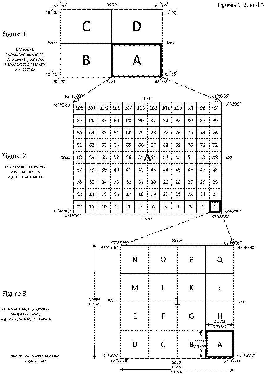
Legislative History
Reference Tables
|
Mineral Resources Regulations |
N.S. Reg. 196/2018 |
|
Mineral Resources Act |
|
|
Note: The information in these tables does not form part of the regulations and is compiled by the Office of the Registrar of Regulations for reference only. |
|
Source Law
The current consolidation of the Mineral Resources Regulations made under the Mineral Resources Act includes all of the following regulations:
|
N.S. |
In force |
How in force |
Royal Gazette |
|
196/2018 |
Dec 18, 2018 |
date specified |
Nov 23, 2018 |
|
|
|
|
|
|
|
|
|
|
|
|
|
|
|
|
|
|
|
|
The following regulations are not yet in force and are not included in the current consolidation:
|
N.S. |
In force |
How in force |
Royal Gazette |
|
|
|
|
|
|
|
|
|
|
|
|
|
|
|
*See subsection 3(6) of the Regulations Act for
rules about in force dates of regulations.
|
ad. = added |
fc. = fee change |
rep. = repealed |
|
|
Provision affected |
How affected |
||
|
.......................................................... |
|
||
|
|
|
||
|
|
|
||
|
|
|
||
|
|
|
||
Note that changes to headings are not included in the above table.
Editorial Notes and Corrections:
|
|
Note |
Effective |
|
1 |
Definitions in subsection 16(1) placed in alphabetical order for the purposes of this consolidation. |
Dec 18, 2018 |
|
2 |
The Public Accountants Act referred to in s. 80 is repealed by s. 34 of the Financial Measures (2019) Act, S.N.S. 2019, c. 4. Refer to the Chartered Professional Accountants Act, S.N.S. 2015, c. 55 for continued licensing of public accountants. |
Sep 1, 2019 |
|
|
|
|
Repealed and Superseded:
|
N.S. |
Title |
In force |
Repealed |
|
222/2004 |
Mineral Resources Regulations |
Nov 4, 2004 |
Dec 18, 2018 |
Note: Only regulations that are specifically repealed and replaced appear in this table. It may not reflect the entire history of regulations on this subject matter.