| This consolidation is unofficial and is for reference only. For the official version of the regulations, consult the original documents on file with the Registry of Regulations, or refer to the Royal Gazette Part II. |
| Regulations are amended frequently. Please check the list of Regulations by Act to see if there are any recent amendments to these regulations filed with our office that are not yet included in this consolidation. |
| Although every effort has been made to ensure the accuracy of this electronic version, the Registry of Regulations assumes no responsibility for any discrepancies that may have resulted from reformatting. |
| This electronic version is copyright © 2016, Province of Nova Scotia, all rights reserved. It is for your personal use and may not be copied for the purposes of resale in this or any other form. |
Blomidon Provincial Park Designation of Additional Lands
made under Section 8 of the
Provincial Parks Act
R.S.N.S. 1989, c. 367
O.I.C. 74-1381 (December 19, 1974), N.S. Reg. 122/74
O.I.C. 2015-179 (June 16, 2015), N.S. Reg. 200/2016
O.I.C. 74-1381
The Governor in Council on the report and recommendation of the Minister of Lands and Forests dated the 3rd day of December, A.D., 1974, pursuant to the provisions of Section 2 of Chapter 244 of the Revised Statutes of Nova Scotia, 1967, the Provincial Parks Act, is pleased to:
(a) constitute all that area of land including land covered with water owned by Her Majesty in right of the Province of Nova Scotia, and situate at or near Blomidon, in the County of Kings, Province of Nova Scotia, to be a Provincial Park, said area of land being included within the boundaries of the lands described in Schedule “A” and shown outlined on the Plan of Survey marked Schedule “B”, both Schedules attached to and forming part of the report and recommendation, and
(b) declare the name by which the park shall be known as “Blomidon Provincial Park”.
Schedule “A”
Blomidon Provincial Park
All that certain lot, piece or parcel of land situate, lying and being in Blomidon, County of Kings, Province of Nova Scotia, as the same is shown on Plan E-5-23, recorded in the Crown Land Registry office, Department of Lands and Forests, Halifax, and being more particularly described as follows:
Beginning at a Crown Land Wooden Post (C.L.W.P.) marked K221 situate on the southern boundary of lands now or formerly of the Minas Basin Pulp and Paper Company Limited and the eastern boundary of the Old Scott’s Bay Road;
Thence north eighty degrees eleven minutes east (N 80° 11' E) along a southern boundary of lands now or formerly owned by the said Minas Basin Pulp and Paper Company Limited, distant three thousand one hundred twenty-seven decimal zero eight (3127.08) feet to a C.L.W.P. marked K220;
Thence north fifty-six degrees forty-nine minutes east (N 56° 49' E) along a southern boundary of lands now or formerly owned by the said Minas Basin Pulp and Paper Company Limited distant one thousand one hundred forty-five decimal seventy-six (1145.76) feet to a C.L.W.P. marked K219;
Thence north ten degrees forty-one minutes west (N 10° 41' W) along an eastern boundary of lands now or formerly owned by the said Minas Basin Pulp and Paper Company Limited distant seven thousand nine hundred eight decimal twelve (7908.12) feet to a C.L.W.P. marked K218;
Thence south eighty-six degrees forty-one minutes east (S 86° 41' E) along a southern boundary of lands now or formerly owned by the said Minas Basin Pulp and Paper Company Limited distant two thousand six hundred forty (2640) feet to a C.L.W.P. marked K217;
Thence south eighty-six degrees forty-one minutes east (S 86° 41' E) along a southern boundary of lands now or formerly owned by the said Minas Basin Pulp and Paper Company Limited to the mean high water line of the Minas Basin;
Thence southerly and southwesterly along the mean high water line of the Minas Basin to a point being south thirty degrees nine minutes east (S 30° 09' E) distant forty (40) feet more or less from a Crown Land Iron Post (C.L.I.P.) marked K237;
Thence north thirty degrees nine minutes west (N 30° 09' W) along the eastern boundary of lands reserved by Dwight Bigelow distant forty (40) feet more or less to a C.L.I.P. marked K237;
Thence north thirty degrees nine minutes west (N 30° 09' W) along the eastern boundary of said lands reserved by Dwight Bigelow distant one hundred thirty-six decimal forty-nine (136.49) feet to a C.L.I.P. marked K236;
Thence south sixty-seven degrees forty-nine minutes west (S 67° 49' W) along the northern boundary of said lands reserved by Dwight Bigelow distant six hundred forty-three decimal fifty (643.50) feet to a C.L.I.P. marked K235;
Thence south forty-three degrees thirty-four minutes west (S 43° 34' W) along the northern boundary of said lands reserved by Dwight Bigelow distant two hundred two decimal forty-nine (202.49) feet to a C.L.I.P. marked K234;
Thence south fifty-one degrees forty-four minutes east (S 51° 44' E) along the southwestern boundary of said lands reserved by Dwight Bigelow distant two hundred seventy-four decimal eighty-two (274.82) feet to a C.L.I.P. marked K233;
Thence south fifty-one degrees forty-four minutes east (S 51° 44' E) along the southwestern boundary of said lands reserved by Dwight Bigelow distant one hundred five (105) feet
more or less to the mean high water line of Minas Basin;
Thence southwesterly along the mean high water line of Minas Basin to a point being south sixty-three degrees fifty-six minutes east (S 63° 56' E) distant sixty-six (66) feet from a C.L.I.P. marked K232;
Thence north sixty-three degrees fifty-six minutes west (N 63° 56' W) along the northeastern boundary of lands now or formerly owned by Norris Green distant sixty-six (66) feet more or less to a C.L.I.P. marked K232;
Thence north sixty-three degrees fifty-six minutes west (N 63° 56' W) along the northeastern boundary of said lands now or formerly owned by Norris Green distant one hundred decimal ninety-eight (100.98) feet to a hub marked “X”;
Thence north fifty-four degrees twenty-two minutes west (N 54° 22' W) along the northeastern boundary of said lands now or formerly owned by Norris Green distant one hundred eighty-eight decimal thirty (188.30) feet to a C.L.I.P. marked K231;
Thence northerly and northwesterly along the eastern and northern boundary of the road leading to Canning to a point being north forty-one degrees forty-nine minutes east
(N 41° 49' E) from C.L.I.P. marked K230;
Thence south forty-one degrees forty-nine minutes west (S 41° 49' W) crossing the said road leading to Canning to a C.L.I.P. marked K230 bearing north twenty degrees seventeen minutes nineteen seconds west a calculated distance of seven hundred forty-seven decimal fifty-two (747.52) feet from C.L.I.P. K231 above mentioned;
Thence south forty-one degrees forty-nine minutes west (S 41° 49' W) along the northwestern boundary of lands now or formerly owned by James Bigelow distant ninety-five decimal fifty-six (95.56) feet to a C.L.I.P. marked K229;
Thence south sixty-seven degrees thirty-three minutes west (S 67° 33' W) along the northern boundary of lands now or formerly owned by the Truth for Youth Bible Camp distant one hundred thirty-two decimal sixty-six (132.66) feet to a C.L.I.P. marked K228;
Thence south fifteen degrees twenty-eight minutes east (S 15° 28' E) along the western boundary of said lands now or formerly owned by the Truth for Youth Bible Camp distant one hundred forty-three decimal eighty-eight (143.88) feet to a C.L.I.P. marked K227;
Thence south ten degrees two minutes east (S 10° 02' E) along the western boundary of said lands now or formerly owned by the Truth for Youth Bible Camp distant one hundred seventy-four decimal ninety (174.90) feet to a C.L.I.P. marked K226;
Thence north fifty-eight degrees thirteen minutes west (N 58° 13' W) along the northern boundary of said lands now or formerly owned by Norris Green distant two thousand eight hundred eighty-eight decimal eighty-two (2888.82) feet to a C.L.W.P. marked K225;
Thence north fourteen degrees forty-three minutes west (N 14° 43' W) along an eastern boundary of said lands now or formerly owned by the Minas Basin Pulp and Paper Company Limited distant seven hundred twenty-three decimal eighty-nine (723.89) feet to a C.L.W.P. marked K224;
Thence north seventy-one degrees four minutes east (N 71° 04' E) along a southern boundary of said lands now or formerly owned by the Minas Basin Pulp and Paper Company Limited distant one thousand four hundred sixty-nine decimal eighty-two (1469.82) feet to a C.L.W.P. marked K223;
Thence north sixty-three degrees fifty minutes east (N 63° 50' E) along a southern boundary of said lands now or formerly owned by the Minas Basin Pulp and Paper Company Limited distant one thousand three hundred decimal twenty (1300.20) feet to a C.L.W.P. marked K222;
Thence northerly along the eastern boundary of the Old Scotts Bay Road to the place of beginning, said place of beginning bearing north zero degrees twenty-seven minutes east (N 00° 27' E) distant two thousand one hundred seventeen decimal twenty-eight (2117.28) feet from the immediate of above described C.L.W.P. marked K222;
All bearings are astronomic.
The above described land having an area of one thousand two hundred seventy-nine (1279) acres more or less.
Schedule “B”
[Note: The map referred to as Schedule “B” was not filed with the Office of the Registrar of Regulations.]
O.I.C. 2015-179
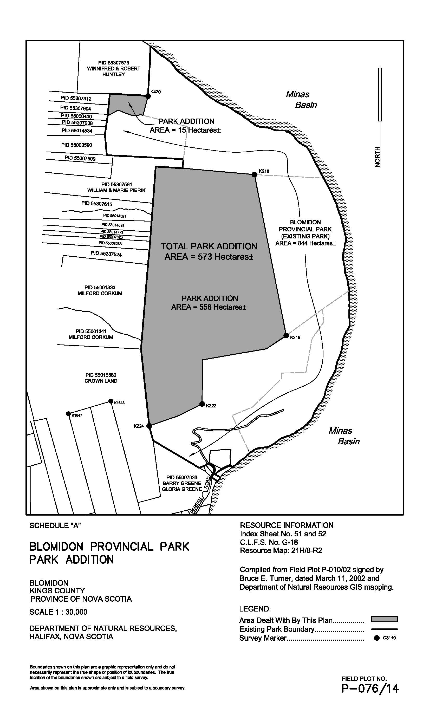
The Governor in Council on the report and recommendation of the Minister of Natural Resources dated January 14, 2015, and pursuant to Section 8 of Chapter 367 of the Revised Statutes of Nova Scotia, 1989, the Provincial Parks Act, is pleased, effective on and after June 16, to
(a) increase the size of Blomidon Provincial Park, originally designated by the Governor in Council by Order in Council 74-1381 dated December 19, 1974, by adding to it the lands shown outlined in bold on the plan marked Schedule “A” attached to and forming part of the report and recommendation; and
(b) authorize the Minister of Natural Resources to execute such documents as may be necessary to achieve the purposes of this order.
Schedule “A”