| This consolidation is unofficial and is for reference only. For the official version of the regulations, consult the original documents on file with the Office of the Registrar of Regulations, or refer to the Royal Gazette Part II. |
| Regulations are amended frequently. Please check the list of Regulations by Act to see if there are any recent amendments to these regulations filed with our office that are not yet included in this consolidation. |
| Although every effort has been made to ensure the accuracy of this electronic version, the Office of the Registrar of Regulations assumes no responsibility for any discrepancies that may have resulted from reformatting. |
| This electronic version is copyright © , Province of Nova Scotia, all rights reserved. It is for your personal use and may not be copied for the purposes of resale in this or any other form. |
Ponhook Lake Nature Reserve Ecological Site Designation
made under subsections 14(1), (2), (3) and (4) of the
O.I.C. 92-942 (effective September 22, 1992), N.S. Reg. 207/92
O.I.C. 2023-358 (effective December 29, 2023), N.S. Reg. 230/2023
Table of Contents
Please note: this table of contents is provided for convenience of reference and does not form part of the regulations.
Click here to go to the text of the regulations.
Appendix A Description of Addition to Ponhook Lake Nature Reserve
Appendix B Map Showing Approximate Boundaries of Addition to Ponhook Lake
Nature Reserve
The Governor in Council on the report and recommendation of the Minister of Education dated the 16th day of September, A.D., 1992, pursuant to subsections (1), (2), (3) and (4) of Section 14 of Chapter 438 of the Revised Statues of Nova Scotia, 1989, the Special Places Protection Act, is pleased to designate as an ecological site the land described in Schedule “A” and shown on a plan attached as Schedule “B” which ecological site shall be managed in accordance with the Management Plan attached as Schedule “C”, all Schedules being attached to and forming part of the report and recommendation, which shall be known as the Ponhook Lake Nature Reserve, effective on the date of publication of the designation in the Royal Gazette.
ALL those certain lots, pieces or parcels of land situate lying and being in the vicinity of Molega, County of Queens, Province of Nova Scotia, being more particularly described as follows and shown in bold line on Schedule “B” attached hereto. Schedule “B” being compiled plan shown Ponhook Lake Nature Reserve dated May 29, 1992, plan number P-066/92.
Parcels 3, 4, 5, 6, 7, 35 and 36 are islands within Molega Lake as shown on said plan;
Parcels 11, 12, 13, 14, 16, 17, 18, 19, 20, 21, 23, 24, 25, 26, 28, 31 and 32 are islands within Ponhook Lake as shown on said plan;
Parcels 27 and 29 are islands within Little Ponhook Lake as shown on said plan;
Parcel 22 consists of the southern one half of Little Glode Island situate within Ponhook Lake as shown on said plan;
Parcels 33 and 34 are islands within Hog Lake as shown on said plan;
Parcels 37, 38 and 39 are islands within Beartrap Lakes as shown on said plan;
Parcel 1 consists of a strip of land 50 metres wide situate on the southwestern side of Tait Run which lies between Hog Lake and Molega Lake as shown on said plan and more particularly described as follows:
BEGINNING at Crown Post Q2335 situate on the ordinary high water mark of Molega Lake;
THENCE northwesterly 400 metres more or less along the ordinary high water mark of Molega Lake and Tait Run to the dam;
THENCE at right angles south westerly 50 metres;
THENCE southeasterly parallel to and 50 metres from the ordinary high water mark of Tait Run and Molega Lake to the Crown line;
THENCE easterly along the Crown line to the PLACE OF BEGINNING.
Parcel 2 consists of a strip of land 50 metres wide situate near the western end of Molega Lake as shown on said plan and more particularly described as follows:
BEGINNING at Crown Post Q5932 situate on the ordinary high water mark of Molega Lake;
THENCE southeasterly 1800 metres more or less along the ordinary high water mark of Molega Lake to another Crown line;
THENCE southerly along the Crown line in the direction of Crown post Q344 to a point situate 50 metres at right angles from the ordinary high water mark of Molega Lake;
THENCE northwesterly parallel to and 50 metres from the ordinary high water mark of Molega Lake to the first described Crown line;
THENCE northerly along the Crown line to the PLACE OF BEGINNING.
Parcel 8 consists of a strip of land 50 metres wide situate near the southwestern end of Molega Lake as shown on said plan and more particularly described as follows:
BEGINNING at Crown Post Q273 situate on the ordinary high water mark of Molega Lake;
THENCE southwesterly 525 metres more or less along the ordinary high water mark of Molega Lake to another Crown line;
THENCE westerly along the Crown line in the direction of Crown post Q274 to a point situate 50 metres at right angles from the ordinary high water mark of Molega Lake;
THENCE northeasterly parallel to and 50 metres from the ordinary high water mark of Molega Lake to the first described Crown line;
THENCE northerly along the Crown line to the PLACE OF BEGINNING.
Parcel 9 consists of a parcel of land situate near the southwestern end of Molega Lake as shown on said plan and more particularly described as follows:
BEGINNING at Crown Post Q361 situate on the ordinary high water mark of Molega Lake;
THENCE southwesterly to Crown post Q362;
THENCE southwesterly to Crown post Q363;
THENCE northeasterly to Crown post Q364 situate on the ordinary high water mark of Molega Lake;
THENCE westerly along the ordinary high water mark of Molega Lake to the PLACE OF BEGINNING.
Parcel 10 consists of a parcel of land situate near the southwestern end of Molega Lake as shown on said plan and more particularly described as follows:
BEGINNING at Crown Post Q357 situate on the ordinary high water mark of Molega Lake;
THENCE southwesterly to the northern boundary of Highway No. 483;
THENCE easterly along the northern boundary of Highway No. 483 to the Crown line;
THENCE northerly to Crown post Q360 situate on the ordinary high water mark of Molega Lake;
THENCE westerly along the ordinary high water mark of Molega Lake to the PLACE OF BEGINNING.
Parcel 15 consists of a strip of land 50 metres wide situate near the southwestern end of Beartrap Lakes as shown on said plan and more particularly described as follows:
BEGINNING at Crown Post Q2194 situate on the ordinary high water mark of Beartrap Lakes;
THENCE westerly and southerly 450 metres more or less along the ordinary high water mark of Beartrap Lakes;
THENCE at right angles easterly 50 metres;
THENCE northerly parallel to and 50 metres from the ordinary high water mark of Beartrap Lakes to the Crown line;
THENCE northerly along the Crown line to the PLACE OF BEGINNING.
Parcel 30 consists of a strip of land near the southern end of Ponhook Lake as shown on said plan and more particularly described as follows:
BEGINNING at Crown Post 1719 situate on the ordinary high water mark of Ponhook Lake;
THENCE southerly 275 metres more or less along the ordinary high water mark of Ponhook Lake to Crown post 1720;
THENCE westerly along the Crown line to the eastern boundary of a 66 foot wide right of way over Crown land;
THENCE northerly along the eastern boundary of said 66 foot wide right of way over Crown land to the first described Crown line;
THENCE northeasterly along the Crown line to the PLACE OF BEGINNING.
[Note: Schedule “B” was not filed with the Registry of Regulations. The map contained in Schedule “B” is available for viewing at the Department of Natural Resources.]
[Note: Schedule “C” was not filed with the Registry of Regulations. The Management Plan contained in Schedule “C” is available from the Department of Natural Resources.]
I, Timothy Halman, Minister of Environment and Climate Change for the Province of Nova Scotia, pursuant to Section 14 of Chapter 438 of the Revised Statutes of Nova Scotia, 1989, the Special Places Protection Act, hereby designate the area of land described in Appendix A and shown on the map attached as Appendix B as an addition to the Ponhook Lake Nature Reserve ecological site designation, N.S. Reg. 207/1992, made by the Minister of Education and approved by the Governor in Council by Order in Council 92-942 dated September 22, 1992.
Pursuant to subsection 14(3) of the Act, this designation is effective on and after the date it is published in the Royal Gazette.
In accordance with subsection 14(6) of the Act, this description will be registered in the registry of deeds office for the registration district in which the lands are situated.
Dated and made at Halifax Regional Municipality, Province of Nova Scotia, November 28, 2023.
sgd. T. Halman
Honourable Timothy Halman
Minister of Environment and Climate Change
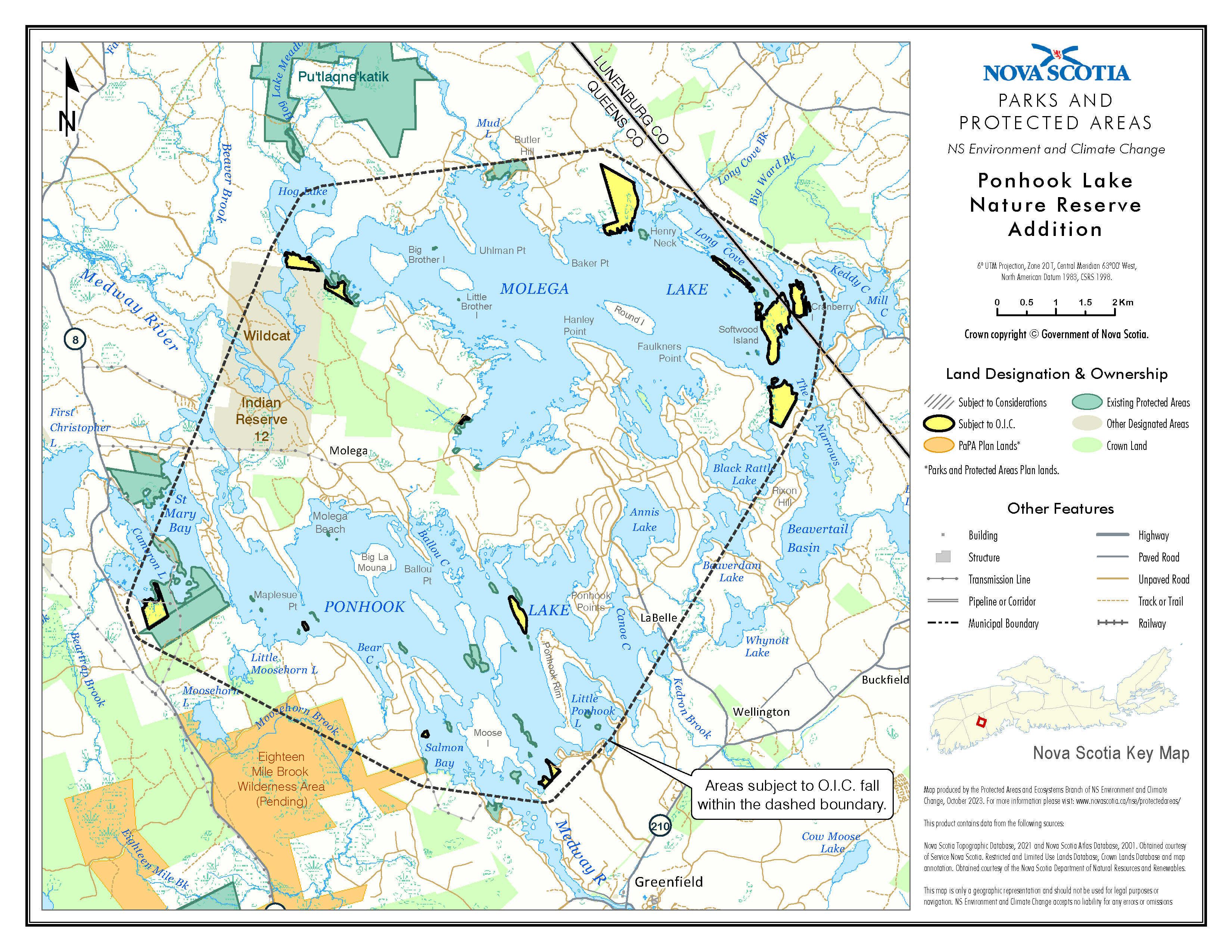
Appendix A
Description of Addition to Ponhook Lake Nature Reserve
ALL those certain lots, pieces, parcels or islands of land located in the Counties of Queens and Lunenburg, Province of Nova Scotia, shown outlined in bold as Ponhook Lake Nature Reserve Addition on Field Plot P-021/22, filed at the Surveys Division of the Department of Natural Resources and Renewables, Halifax, Nova Scotia, and containing a total area of 162.5 hectares more or less.
Appendix B
Map Showing Approximate Boundaries of Addition to
Ponhook Lake Nature Reserve
Legislative History
Reference Tables
Ponhook Lake Nature Reserve Designation |
N.S. Reg. 207/1992 |
Special Places Protection Act |
|
Note: The information in these tables does not form part of the regulations and is compiled by the Office of the Registrar of Regulations for reference only. |
|
Source Law
The current consolidation of the Ponhook Lake Nature Reserve Designation made under the Special Places Protection Act includes all of the following regulations:
N.S. |
In force |
How in force |
Royal Gazette |
207/1992
|
Oct 16, 1992 |
date specified by law1 |
Oct 16, 1992 |
230/2023 |
Dec 29, 2023 |
date specified by law1 |
Dec 29, 2023 |
|
|
|
|
|
|
|
|
|
|
|
|
The following regulations are not yet in force and are not included in the current consolidation:
N.S. |
In force |
How in force |
Royal Gazette |
|
|
|
|
|
|
|
|
|
|
|
|
*See subsection 3(6) of the Regulations Act for
rules about in force dates of regulations.
ad. = added |
fc. = fee change |
rep. = repealed |
|
Provision affected
|
How affected
|
||
|
|
||
|
|
||
Note that changes to headings are not included in the above table.
Editorial Notes and Corrections
|
Note |
Effective |
1 |
Pursuant to subsection 14(3) of the Act, the designation is effective on and after the date it is published in the Royal Gazette. |
|
2 |
The plan referred to as Schedule “B” in the text of the order to N.S. Reg. 206/1992 was not filed with the Registrar of Regulations. |
|
3 |
The management plan referred to as Schedule “C” in the order to N.S. Reg 206/1992 was not filed with the Registrar of Regulations. |
|
|
|
|
Repealed and Superseded
N.S. |
Title |
In force |
Repealed |
|
|
|
|
Note: Only regulations that are specifically repealed and replaced appear in this table. It may not reflect the entire history of regulations on this subject matter.