

 Ship Harbour Long Lake Wilderness Area protects more than 16,500 hectares (ha) of rugged woodlands, lakes and waterways of the Eastern Shore interior. It extends over 30 km, between Musquodoboit Harbour and Mooseland, and meets the Atlantic coast at the upper reaches of Jeddore Harbour.
This is the largest protected area in Halifax Regional Municipality. Together with the adjacent White Lake Wilderness Area and Tangier Grand Lake Wilderness Area, it forms an assemblage of protected lands larger than Kejimkujik National Park, with three times as many lakes.
The protected lakes, waterways, wetlands, old forests and remote forests support many species which depend on healthy, intact ecosystems – such as brook trout, endangered mainland moose and at least four species of rare lichens, including globally endangered boreal felt lichen.
Protection of these lands improves the representation of several of Nova Scotia’s diverse natural landscapes within the province’s protected areas system
Southern portions of the wilderness area are underlain by 350 million-year-old granitic bedrock, which forms a rugged and ridged landscape with numerous lakes. This granite is generally covered by thin stony till and nutrient-poor, acidic soils. Forest productivity is generally poor, with white pine, red spruce, balsam fir, red maple, white birch and other hardwoods common.
Elsewhere, the wilderness area is underlain by half-billion-year-old quartzite bedrock. Here the topography is less rugged and even nearly flat, as between Fishing Lake and Ship Harbour Long Lake. Unrestrained by topography, shallow lakes, like the aptly named Flat Lakes, are connected by stillwaters. Dozens of open and treed bogs are scattered across what is otherwise dense forest of white pine, spruce and balsam fir.
Fish River tracks a jagged course through the quartzite bedrock-controlled landscape, between Scraggy Lake and Lake Charlotte. All but the lower 300 m of this wild river is within the wilderness area. Forests along Ship Harbour Long Lake and up the Fish River to Scraggy Lake are still dominated by softwoods, but soil productivity is better and supports some impressive stands of red spruce, white pine, and scattered eastern hemlock. Mixed stands with yellow birch, white ash, beech, and red maple occur on some slopes and ridges.
At Scraggy Lake, the wilderness area extends into a landscape with elongated hills, or drumlins, which were formed by glaciers. A large, hardwood forest-covered drumlin is a defining feature of this lake.
This scenic wilderness area offers excellent opportunities for wilderness recreation and nature tourism, including angling, hunting, canoeing and hiking.
A fine way to explore Ship Harbour Long Lake Wilderness Area is by canoe or other small craft. There are two primary opportunities: (1) Scraggy Lake – Fish River – Lake Charlotte, at the eastern end of the wilderness area; and (2) the interconnected lakes of the southern portion, between White Lake Wilderness Area and Lays Lake Road. Paddlers can travel to the Atlantic coast in both cases. For the most part, portage trails are neither marked or maintained. The 25 km Skull Lake Loop, between Oyster Pond and Lays Lake Road, has been improved through a partnership with Canoe-Kayak Nova Scotia (CKNS).
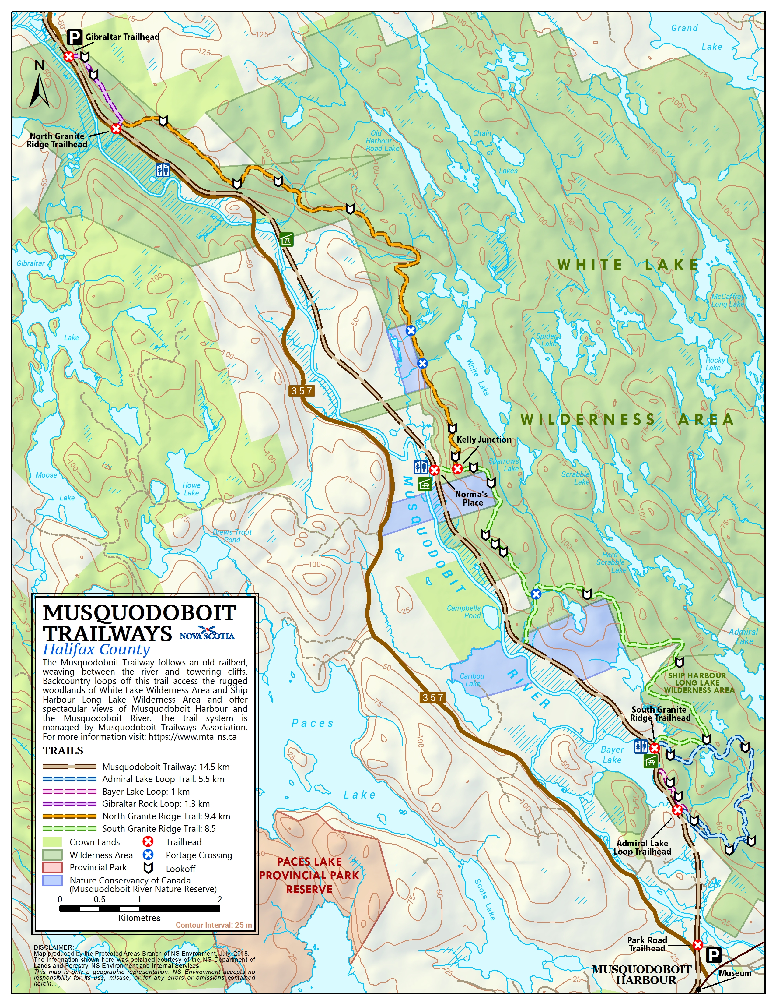
Part of the wilderness area can be experienced on foot by hiking trails of the Musquodoboit Trailways system. Located near Musquodoboit Harbour, the entire 26 km backcountry trail portion of this system extends from Ship Harbour Long Lake Wilderness Area, north, through the adjacent White Lake Wilderness Area. It is accessible from multiple locations off a former railway corridor that is now part of The Great Trail (Trans Canada Trail). The entire system is managed by Musquodoboit Trailways Association (MTA). Additional information is available on MTA’s website.
Many of the area’s lakes and waterways are popular for angling. More than a dozen campsite leases are scattered throughout the wilderness area.
Ship Harbour Long Lake Wilderness Area can be accessed by vehicle via forest access roads around the perimeter and through the middle of the area, using roads which are not within the wilderness area. Public access is possible at numerous locations, including:
- Off Lays Lake Road, with side roads to Portapique (Porcupine) Lake, towards Rocky and Logging lakes, and to within 75 m of Hartman Lake.
- Along Higgins Mine and Murchyville roads, including the bridge at Fish River and within 750 m of Melvin Dam Flowage, on Fish River.
- To the south end of Scraggy Lake, north end of Ship Harbour Long Lake, and northwest end of Lake Charlotte.
Many of these forest access roads do not receive routine maintenance and may be passable only in a high clearance or off-road vehicle. Please check road conditions before planning a trip.
Most of Ship Harbour Long Lake Wilderness Area was designated in 2009 after two years of planning and consultation. The wilderness area was expanded by 332 ha in 2012; by 929 ha in 2015; and by 521 ha in 2020. The 2020 addition includes: (1) 121 ha of land owned by the Nature Conservancy of Canada (NCC) and designated with NCC’s consent, and (2) a 24 ha parcel at the south end of Salmon River Lake which was donated to the Province by an individual.
Designation Documents(2007-2009)
- Read the government news release (September, 2009)
- Download: Ship Harbour Long Lake Wilderness Area Map
 (PDF:1.3mb) - July 2009
 - Download: Newsletter #4 (with map) (PDF:1.5mb)
Designation Proposal Information
- Read the government news release (April 2009)
- Download: Consultation Newsletter #3 (with map) (PDF:1021k)
Other Documents
- Read the government news release (April 2008)
- Download: Consultation Newsletter #1 (with map) (PDF:1.3mb)
- Download: Consultation Newsletter #2 (PDF:837k)
- Wilderness Areas: Frequently Asked Questions
Candidate Wilderness Area Announcement
- Read the government news release (December 2007)
- Download : Information sheet (PDF:559k)
- Download : Map (PDF:1.4mb)