Hunt Features:
Zone 1:Consists of lands north of the Cape Breton Highlands National Park which are not part of the Pollett's Cove-Aspy Fault Wilderness Area. Good road access through most of the zone.
Zone 2: Access is relatively good by network of forestry roads (gravel- take extra spare tires)
Zone 3: Knowledge of local area, access points and land owners would be of advantage. Reduced risk of an early snow at this lower elevation.
Zone 4: Local knowledge of area and where moose have been seen would be of benefit. Reduced risk of an early snow at this lower eleation.
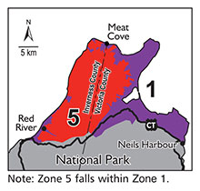
Zone 5: This hunt falls entirely within the Polletts Cove-Aspy Fault Wilderness Area. This is a non-motorized hunt and no permits will be issued from Nova Scotia Environment for ATV use. The Terrain is extremely challenging, making it difficult to pack out a harvested moose.
Hunting in Zone 5
PERSONS CONSIDERING THIS ZONE SHOULD
BE AWARE OF THE FOLLOWING:
Persons considering this hunt should be aware of the following:
- motorized vehicle use is not permitted in Zone 5
- access points are limited and mostly through small private land holdings
- terrain is rugged and conditions will be physically challenging
- careful consideration must be made in undertaking this type of hunt
|
Moose Management
Zone Descriptions
NOTE: Following are legal descriptions of the five Moose Management Zones
in Cape Breton where moose hunting is permitted. There are a number
of locally used names for roads used as the boundary between Zone 2
and Zone 3. They do not appear on legal maps of the area but do appear
on roadside signs. These locally used names are not part of the legal
definition of the zones but for your convenience have been inserted
immediately after the formal place names as (CAPITALIZED,
ITALICIZED, BOLD-FACED ITEMS IN BRACKETS).
See the Moose Hunting Regulations
at https://novascotia.ca/just/regulations/regs/wimoose.htm
|
 Zone 1 Zone 1
("north of Cape Breton Highlands National Park")
Legal
Description
Moose Management Zone 1 includes certain lands within Nova Scotia and is more particularly described as follows:
Beginning at a point where the northern boundary of The Cape Breton
Highlands National Park meets the ordinary high water mark (OHWM) of
the northern shoreline of Neils Harbour;
Thence, in a generally westerly direction following the northern boundary
of the said Park across the northern peninsula of Cape Breton Island to the
OHWM of the Gulf of St. Lawrence at the mouth of the MacKenzie River;
Thence, in a northerly direction along the OHWM of the Gulf of St.
Lawrence to Cape St. Lawrence;
Thence, in an easterly direction along the OHWM of the Cabot Strait and
Bay St. Lawrence to Money Point;
Thence, in a southerly direction along the OHWM of Aspy Bay, Cabot
Strait and Neils Harbour to the Point of Beginning. Together with all
inshore and offshore islands, and including all harbours, bays, coves,
rivers and inlets.
Saving and excepting all lands located in Moose Management Zone 5.
(Click to see larger image)
|
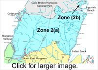
Zone
2
("immediately
south of Cape Breton Highlands National Park" )
Legal Description
Zone 2 includes certain lands within Nova Scotia and
is comprised of parcels "A" and"B", being more
particularly described as follows:
Parcel "A"
Beginning at a point where the southern
boundary of The Cape Breton Highlands National Park meets the ordinary
high water mark (OHWM) on the western shoreline of South Bay Ingonish;
Thence, in a generally westerly direction along the southern
boundary of the said Park across the northern peninsula of Cape Breton
Island to the OHWM of the Gulf of St. Lawrence at the mouth of the
Cheticamp River;
Thence, in a generally southerly direction along the OHWM of
the Gulf of St. Lawrence to the mouth of the Margaree River;
Thence, in a southeasterly direction along OHWM of the southern
shoreline of the Margaree River to the Cabot Trail;
Thence, in a southerly and easterly direction along the Cabot
Trail to North East Margaree at a point where the road southerly from
Kingross meets the Cabot Trail;
Thence, in a northerly direction along the said Kingross Road
a distance of approximately 4.5 kilometres to Margaree Valley at
a point where the Frasers Mountain Road (FIELDING ROAD)
to the Highlands joins the said
Kingross Road;
Thence, in a generally easterly direction along the said Frasers
Mountain Road (FIELDING ROAD)to the point
where it meets the main road in the Highlands (HIGHLAND
ROAD) running
northerly from Hunters Mountain;
Thence, in a northerly direction along the main road through
the Highlands a distance of approximately 2.5 kilometres to a secondary
road (KELLY ROAD) just past the Middle
Branch North River, the said road leading easterly to the MacDonalds
Mountain fire tower (NORMAN FIRE TOWER);
Thence, in an easterly and northerly direction along the said
secondary road (KELLY ROAD) a distance
of approximately 11 kilometres to the point where it (INTERSECTS
THE MARIANNA ROAD, NORTH ON THE MARIANNA ROAD TO THE BARACHOIS RIVER)
crosses the Barachois
River;
Thence, in a generally southeasterly direction downstream along the said River
to the point where the said River meets the OHWM of St. Anns Bay;
Thence, in a northeasterly direction along the OHWM of St. Anns
Bay and the Atlantic Ocean to Stanley Point at the northerly edge of
Cape Smokey;
Thence, westerly along the OHWM of the southern and western
shorelines of South Bay Ingonish to the Point of Beginning.
Together with all inshore and offshore islands, and including all harbours,
bays, coves, rivers and inlets .
Parcel "B"
Beginning at a point where the southern
boundary of the Cape Breton Highlands National Park (CBHNP), just to
the north of Ingonish, meets the Ordinary High Water Mark (OHWM) of the
Atlantic Ocean;
Thence, in a westerly, southerly and easterly direction following
the said boundary of the CBHNP, and enclosing the communities of Ingonish
Centre and Ingonish, and the surrounding area, to a point where the
said boundary meets the OHWM of the Clyburn Brook;
Thence, in an easterly direction downstream along the OHWM of
the Clyburn Brook to the point where the said Brook meets the OHWM
of North Bay Ingonish.
Thence, in a generally westerly, northerly, easterly and northerly
direction following the OHWM of the western shoreline of North Bay
Ingonish and the Atlantic Ocean to the Point of Beginning.
Together with all inshore and offshore islands, and including all harbours,
bays, coves, rivers and inlets.
(Click to see larger image)
|
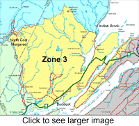 Zone
3 Zone
3
("Baddeck, Margaree, Hunters
Mountain to Fraser Mountain Road")
Legal Description
Zone 3 includes certain lands within Nova Scotia and is more particularly described
as follows:
Beginning at a point where the Barachois River meets the ordinary
high water mark (OHWM) on the western shoreline of St. Anns Bay;
Thence, southerly and easterly direction following the OHWM
of the western, southern and eastern shorelines of St. Anns Bay to
Cape Dauphin;
Thence, easterly in a straight line across the mouth of The
Great Bras d' Or to Table Head;
Thence, easterly along the OHWM of the Atlantic Ocean to the
county boundary between Victoria and Cape Breton Counties;
Thence, in a generally southwesterly direction along the said
County boundary across Boularderie Island and the waters of St. Andrews
Channel to a point where the waters of the St. Andrews Channel join
the waters of the Great Bras d' Or;
Thence, northwesterly in a straight line to a point midway between
McKay Point to the south and Red Head to the north;
Thence, in a westerly direction along the centreline of St.
Patricks Channel to the mouth of Nyanza Bay;
Thence, northerly and easterly along the centreline of Nyanza
Bay to the mouth of the Baddeck River;
Thence, upstream along the centre of Baddeck River to its intersection
with the centreline of Highway No. 105;
Thence, northwesterly along the said Highway to its intersection
with the Cabot Trail;
Thence, northerly along the Cabot Trail to North East Margaree
at a point where the road southerly from Kingross meets the Cabot Trail;
Thence, in a northerly direction along the said Kingross Road
a distance of approximately 4.5 kilometres to Margaree Valley at
a point where the Frasers Mountain Road (FIELDING ROAD) to
the Highlands joins the said Kingross Road;
Thence, in a generally easterly direction along the said Frasers
Mountain Road (FIELDING ROAD) to the point
where it meets the main road in the Highlands (HIGHLAND
ROAD) running northerly from
Hunters Mountain;
Thence, in a northerly direction along the main road through
the Highlands a distance of approximately 2.5 kilometres to a secondary
road just past the Middle Branch North River, the said road leading
easterly to the MacDonalds Mountain fire tower (NORMAN FIRE
TOWER);
Thence, in an easterly and northerly direction along the said
secondary road (KELLY ROAD) a distance
of approximately 11 kilometres to the point where it (INTERSECTS
THE MARIANNA ROAD, NORTH ON THE MARIANNA ROAD TO THE BARACHOIS RIVER)
crosses the Barachois
River;
Thence, in a generally southeasterly direction downstream along
the said River to the point where the said River meets the OHWM of
St. Anns Bay at the Point of Beginning. Together with all inshore
and offshore islands, and including all harbours, bays, coves, rivers
and inlets.
(Click to see larger image)
|

Zone 4
(Cabot Trail south to Port Hawkesbury)
Legal Description
Zone 4 includes certain lands within Nova Scotia and is more particularly described
as follows:
Beginning at a point where the centre of Baddeck River intersects
with the centerline of Highway No. 105;
Thence, northwesterly along the said Highway to its intersection
with the Cabot Trail;
Thence, in a northerly, westerly and northerly direction along
the Cabot Trail to the point where the Cabot Trail intersects the western
shoreline of the Margaree River near Margaree Harbour;
Thence, northerly along the said western shoreline to the ordinary
high water mark (OHWM) of the Gulf of St. Lawrence;
Thence, in a generally southerly direction along the OHWM of
the Gulf of St. Lawrence to Hefferman Point on the northeastern shoreline
of the Strait of Canso;
Thence, in a southeasterly direction along the OHWM of the northeastern
shoreline of the Strait of Canso to Grant Point near the mouth of Ship
Harbour;
Thence, in a southeasterly direction along the OHWM of the northeastern
shoreline of Ship Harbour to the county boundary between Inverness
and Richmond Counties;
Thence, northeasterly along the said County boundary to the
point where it meets the OHWM of West Bay;
Thence, northerly along the said County boundary across the
waters of West Bay and The Bras d' Or Lake to the county boundary line
between Victoria and Cape Breton Counties;
Thence, in a northeasterly direction along the Victoria-Cape
Breton County boundary through the Barra Strait to a point where the
waters of the St. Andrews Channel join the waters of the Great Bras
d' Or;
Thence, northwesterly in a straight line to a point midway between
McKay Point to the south and Red Head to the north;
Thence, in a westerly direction along the centreline of St.
Patricks Channel to the mouth of Nyanza Bay;
Thence, northerly and easterly along the centreline of Nyanza
Bay to the mouth of the Baddeck River;
Thence, upstream along the centre of the Baddeck River to its
intersection with the centreline of Highway No. 105 at the Point
of Beginning. Together with all inshore and offshore islands, and
including all harbours, bays, coves, rivers and inlets.
(Click to see larger image)
|
Zone 5
Legal Description
Moose Management Zone 5 includes certain lands within Nova Scotia known as the Pollets Cove-Aspy Fault Wilderness Area, as designated under subsection 11(2) of the Wilderness Areas Protection Act and described in Schedule B to that Act.
(Click to see larger image)
|
