
Mineral Resource Land-Use Maps
DP ME 47, Version 2, 2002. Digital Version of Nova Scotia Department of Natural Resources, Open File Maps ME 2000-4, Mineral Resource Land-Use (MRLU) Maps, Scale 1:50 000, Compiled by D. B. Hopper, F. J. Bonner, B. E. Fisher and A. N. Murphy, 2000.
Abstract
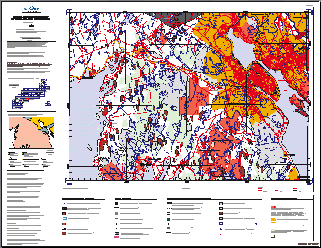
A total of 98 planimetric (1:50 000 scale) Mineral Resource Land-Use (MRLU) maps combine to form a thematic atlas, which covers the province of Nova Scotia including all near-shore islands and Sable Island. The main purpose in preparing this Atlas is to provide the public with a single geographic compilation of mineral resource and related land-use information at a reasonably detailed scale. A key objective is to create a useful reference for practitioners working in land-use and environmental planning, geotechnical firms and groups involved in community economic development.
The MRLU maps display the location and distribution of mineral and energy resources and related activities as well as aspects of environmental geology that relate to land-use and environmental planning. Special land-use designations on Crown and some privately-owned land are shown to indicate how Nova Scotia′s land base varies regarding the ability of mineral resource interests to access land and hold secure tenure. Please note: because these maps were compiled from many different data sources with different scales and projections, some of the overlapping thematic data appears "shifted" relative to each other.
The first version of this digital product was released in March, 2002. The second version of this digital product was released in November, 2002.This version has been updated with 1:10 000 base information and the latest version of the Restricted and Limited Use Land Database.
Disclaimer
The DATA is provided to the USER on an "as is" basis, without warranties of any kind, express or implied. The entire risk as to the quality and accuracy of the DATA is with the USER and the USER shall use his/her own judgment in making use of the DATA or drawing conclusions based upon it. NR&R shall not be liable to the USER, his/her clients, servants, agents, contractors, assigns, or to any other person for any loss or damage of any kind including personal injury or death arising from the use of the DATA or accompanying written materials, or from errors, deficiencies or faults therein, whether such damage is caused by negligence or otherwise. If errors or omissions are found in the DATA, the USER will notify NR&R. The terms and conditions of the license accompany the downloaded digital product.
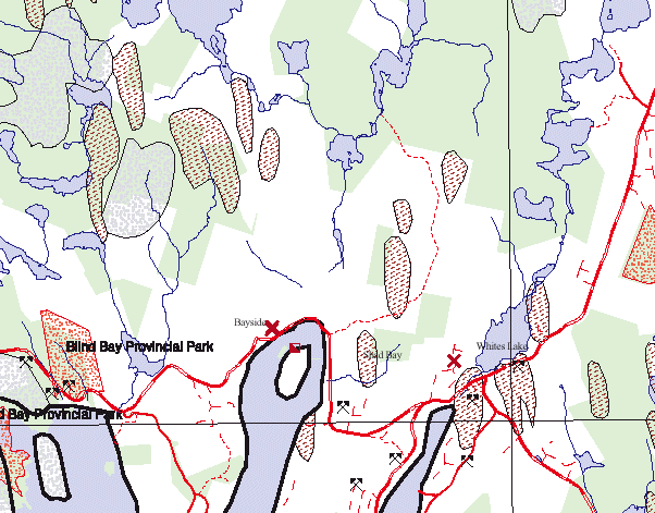
A Sample Image of an MRLU Map
(Sample image -
Click to view an enlargement from this image
)
Format
Portable Document Format (PDF) and TXT files compressed in self-extracting EXE/ZIP files (more information on data formats)
Size
PDF - 0.3 MB to 12.3 MB (compressed and uncompressed)
Projection
The data is in six-degree Universal Transverse Mercator (UTM) projection, Zone 20, Central Meridian 63° 00' West using the North American Datum of 1927 (NAD27).
Downloading Instructions
The data files have been compressed using PKZIP into a single, self-extracting EXE file.
- Read the Licence before accepting the data.
- Download the self-extracting EXE file to the desired location on your hard drive.
- Double click or "RUN" the EXE file and the data files will be unzipped automatically.
The EXE file can also be opened in WinZip to view and extract the compressed files in the data set.
On UNIX platforms, the unzip command will extract the compressed files in the EXE.
All data sets are in six-degree Universal Transverse Mercator (UTM) Zone 20 projection using the NAD27 datum. A readme file and a copy of the licence agreement are also included with each data set.