
Acid Rock Drainage
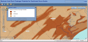
This map was developed by the Department of Natural Resources and shows the potential of bedrock to generate acid rock drainage (ARD) if physically disturbed or exposed. Online Interactive Map for viewing Acid Rock Drainage risk in Southwestern Nova Scotia.
This map is meant to inform landowners, developers and municipal planners about the geological hazard of ARD and to identify where the bedrock in southwestern Nova Scotia is potentially sulphide-bearing and may develop ARD if physically disturbed or exposed, by drilling, blasting or excavation. There are three ARD potential categories: high, moderate and low. This map is intended to be used as a tool for making land-use and environmental planning decisions by indicating where precaution is needed, or further analysis is likely required, before engaging in activities that disturb or expose bedrock
The bedrock acid rock drainage potential digital product for southwestern Nova Scotia illustrates the potential of bedrock to generate ARD if physically disturbed or exposed. The purpose of this digital product is to inform landowners, developers and municipal planners about the geological hazard of acid rock drainage (ARD) and to identify where the bedrock in southwestern Nova Scotia is potentially sulphide-bearing and may develop ARD if physically disturbed or exposed. Disturbing the bedrock refers to activities that physically alter and/or expose the bedrock, such as drilling, blasting and excavation.There are three ARD potential categories: high, moderate and low. This data is intended to be used as a tool for making land-use and environmental planning decisions by indicating where precaution is needed, or further lithogeochemical analysis is likely required, before engaging in activities that disturb or expose bedrock.
Staff contact – Brian Fisher
RELATEd PRODUCTS