
SW Nova Bedrock
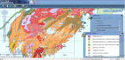
This digital product is a compilation of geological data which was collected as part of the mapping of the Meguma Terrane of southwestern Nova Scotia by C.E. White. The principal goals of this project are to produce a series of 1:50 000 scale geological bedrock maps of the area, to describe and interpret the sedimentary, igneous, metamorphic and deformational history of the Cambrian to Early Devonian metamorphic rocks, and to evaluate the area's economic potential. The data was used to create Nova Scotia Department of Natural Resources (NSNR&R) Open File Maps OFM ME 2012-076 to 2012-101, compiled by C. E. White, 2012. The digital product was created by the NSNR&R, Mineral Resources Branch (MRB) staff. The original digital data was compiled from a number of sources and supplemented by field done during the course of the project. The digital product contains layers for geological features such as: age dates, anticlines/synclines, areas of concentrated drilling, drillholes, dykes, faults, fossils, bedrock geologic units, geological contacts, gold districts, mines, mineral occurrences, small outcrops, quarries, shafts, stockworks, structural data, and shear zones. Online Interactive Map for viewing bedrock maps of southwestern Nova Scotia.
Staff contact – Chris White
RELATEd PRODUCTS