
Wet Areas Mapping and Flow Accumulation Channel
 Provincial wet areas mapping (WAM) is the product of research work carried out by the Forest Watershed Research Centre at the University of New Brunswick (http://watershed.for.unb.ca/). This project was funded by several government and industry partners (see list of partners below).
The WAM model predicts where water will naturally flow and/or accumulate in the landscape based on digital elevation (DEM) data and the known location of surface water bodies and wetlands. In essence, WAM is a "cartographically derived depth-to-water index."
It is important for users of WAM to understand that map-generated depth values may not represent actual depth to a water table or ground water under all conditions, but they do represent end-of-summer soil wetness values which relate to the likelihood of there being natural water present at a given depth within the general vicinity of any point of interest. As such, this index can be used to infer on-site drainage condition (well, moderately well, imperfect, poor, very poor) as affected by local topography and closeness to already mapped open water bodies (streams, lakes, shorelines). Local drainage variations caused by varying soil texture, geological strata, micro-topography, end-of-summer climate conditions, and human disturbances or infrastructure are not reflected by WAM.
Extensive use has shown that WAM is a very useful tool for suggesting where water generally flows and accumulates across the landscape. No claims, however, are made by NSNR&R, UNB, or project partners as to the accuracy of WAM, and it is recommended that all cost or value related interpretations be verified by on-site survey.
Note: The WAM flow channel layer is a line layer that predicts the location of potential (as yet) unmapped streams or below ground flow channels. For a predicted flow channel to be shown, a minimum of 4 ha of land must contribute flow to that point. All predicted flow channels eventually connect to a mapped water body.
The WAM project was completed under contract by the University of New Brunswick in 2005-2007. Contributing partners to the project were:
- Nova Scotia Department of Natural Resources
- Bowater Mersey Paper
- J.D. Irving Ltd.
- Neenah Paper
- StoraEnso Port Hawkesbury
- Nova Forest Alliance Model Forest
- Agriculture and Agri-Food Canada
- Parks Canada
- Service Nova Scotia Environment and Labour
- Service Nova Scotia
WAM products made available here for public use are through the courtesy of project partners.
Updated October 2012
Need A Map Viewer? ...
In order to view our digital files on your computer, you require mapping software (e. g. ArcView®, MapInfo®, AutoCAD®). If you do not have this software, ESRI* provides a FREE Map Viewer called ArcExplorer® which you can download over the Internet. ArcExplorer® works with our *.shp files.
Downloading Instructions
To download the self-extracting archive (*.exe), place the cursor over the area of interest in the map below and click. Alternatively, place the cursor over the county name hyperlink below the map and click. Save the file to the desired location on your hard drive. Execute the downloaded file on your local computer to decompress the shapefiles - you will be offered the opportunity to select an output folder. You must be using Microsoft Windows. NR&R accepts no liability for any errors or deficiencies on this map.
View WAM metadata (detailed information about the WAM layer for a sample county)
Download flow accumulation data
View flow accumulation channels metadata
Projection: NAD 1983 CSRS98 UTM Zone 20N
Self-extracting archive contents:
WAM:
- wtbl.lyr - ArcGIS 9.2 layer file
- wtbl.avl - ArcView 3.x legend file
- wtbl.shp.xml - Metadata file viewable in ArcCatalog or Internet Explorer (allow active content)
Flow accumulation channels:
- ns_floacc.shp (flow accumulation shapefile for all of Nova Scotia)
- ns_floacc.shp.xml - Metadata file
Please select the county of interest:
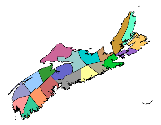
| Antigonish | Guyborough | Lunenburg | Shelburne |
| Annapolis | Hants | Pictou | Victoria |
| Colchester | Kings | Queens | Yarmouth |
| Cape Breton | Inverness | Richmond | |
| Cumberland | Halifax East | St. Marys | |
| Digby | Halifax West | Sable I |