
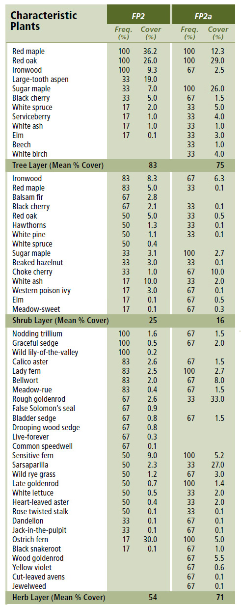
Forest Vegetation types - FP2
FP2 — Red maple – Red oak / Bellwort – Nodding trillium
Acer rubrum – Quercus rubra / Uvularia sessilifolia – Trillium cernuum
FP2a —Sugar maple variant
Acer saccharum
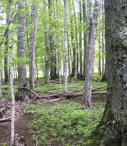 |
Greenwood, Kings County |
Concept: The Red maple - Red oak / Bellwort - Nodding trillium forest is characterized by high levels of red oak and maple in the canopy. It is distinguished from other floodplain forests based on its restricted geographic distribution, reduced fern cover, and prominent representation of species like red oak, bellwort and black cherry. The sugar maple variant (FP2a) describes stands with prominent levels of sugar maple in the canopy.
Vegetation: This closed canopy forest features red oak with prominent levels of either red maple or sugar maple. Most occurrences of FP2 support red maple, but somewhat richer and/or older stands feature low to moderate levels of sugar maple. Ironwood is a frequent but minor component of the lower canopy. Other tree species (e.g. black cherry, elm, white spruce, white ash) may be present, but are less common. The understory is open and often sparse, except in young or disturbed stands where shrub cover is promoted. Herbaceous cover is low to moderate depending on available moisture. Bryophyte prominence is reduced. This ecosystem features common floodplain species like nodding trillium, late goldenrod, graceful sedge and brome-like sedge.
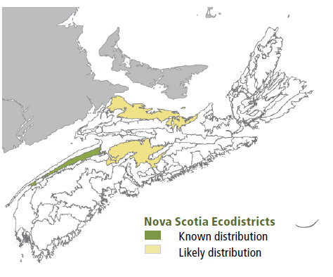
Environmental Setting: FP2 is mainly associated with fresh to fresh-moist, nutrient rich to very rich alluvium soils. Most occurrences are on flat or gently sloping floodplains. FP2 sites are often broken up by seasonally active channels and small depressions. Soils are very deep and largely free of coarse fragments. This Vegetation Type (VT) is mainly found in the western ecoregion (along the Annapolis River and major tributaries), but may occur in other warm ecoregions with sandy riparian soils. Annual or biannual flood cycles are typical. Known Canadian occurrences of this mid to late successional forest are limited to Nova Scotia, but the ecosystem may occur in parts of southern New Brunswick.
Successional Dynamics: This ecosystem can be expressed at a variety of successional stages. Typical stands are relatively stable but expected to transition to a later successional stage defined by the sugar maple variant (FP2a). Successional history is otherwise not fully understood. Most known occurrences have been heavily impacted by past land use activity, including cultivation, land clearing and tree harvest. Other disturbance agents include flooding, ice scour, insects and disease.
Ecological Features: This linear ecosystem occurs in unconnected patches along riparian corridors. It features a broad representation of temperate plants, sandy soil and sometimes complex microtopographic features. Plant species richness is lower than some floodplain forests but generally moderate to high. This ecosystem may provide habitat for rare plants such as Canada wood-nettle, wild leek, hooked agrimony and blue cohosh. Small ox bow swamps and inactive riparian channels are often embedded within this ecosystem, providing favourable habitat for a broad variety of insects and vertebrates. This ecosystem often includes large mast and cavity trees such as oak, black cherry and white ash. It also may support impressively large ironwood trees. Similar to other riparian forests, intact stands help reduce the effects of flooding and erosion, provide structure and woody material to aquatic systems, and promote riparian connectivity. Old growth potential is generally reduced in this VT, but it is higher for the sugar maple variant.
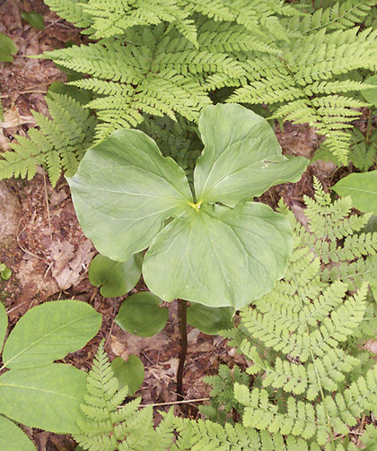 |
| Nodding trillium |
Distinguishing Features: Red oak is a significant component of the overstory. Floodplain features such as seasonally active channels and debris piles are evident. Abundant aster and goldenrod species, sedges and grasses and meadow rue help define this vegetation type.
| Slope Position: | Level10 |
Surface Stoniness: |
(Non - Slightly)9 (Moderately)1 |
Bedrock Outcrop: |
(Non-rocky)9 (Slightly - Moderately)1 |
Elevation Range: |
12 - 39m |
Slope Gradient: |
Level10 |
Aspect: |
None10 |
Exposure: |
Mod. sheltered8 Moderate1 nd1 |
Microtopography: |
Level3Slightly3Extremely2 Moderately2 |
Drainage: |
Well8 Moderately well1 nd1 |
Soil Type: |
ST87 nd3 |
Parent Material: |
Alluvium10 |
Rooting Depth (cm): |
(>45)3 nd7 |
Duff Thickness (cm): |
(0-5)6 nd4 |
![]()