
Forest Vegetation types - WD2
WD2 — Red maple / Cinnamon fern / Sphagnum
Acer rubrum / Osmunda cinnamomea / Sphagnum spp.
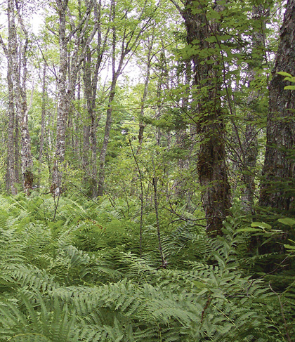 |
Burnt Dam Flowage, Kings County |
Concept: This common and widespread ecosystem is one of three wet red maple forests (WD2, WD3 and WD4) classified from Nova Scotia. It has lower tree and herbaceous species richness and soil fertility than WD3, and it lacks the Atlantic Coastal Plain flora that sets it apart from WD4. The Red maple / Cinnamon fern / Sphagnum forest is found on peat or poorly drained mineral soil, with low to moderate nutrient availability. It persists as an edaphic climax.
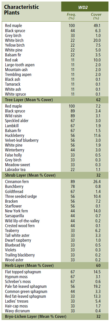
Vegetation: Canopy development is intermediate to high and almost entirely dominated by red maple. Other tree species are far less frequent and seldom abundant. The woody understory supports moderate cover but is species-poor and largely occupied by regenerating trees with scattered wild raisin and speckled alder. The herbaceous layer is better developed but also species-poor; only cinnamon fern and goldthread are frequent. Bryophyte development is moderate, composed of sphagnum and lesser amounts of common upland moss and liverwort species. Flat topped sphagnum is characteristic.
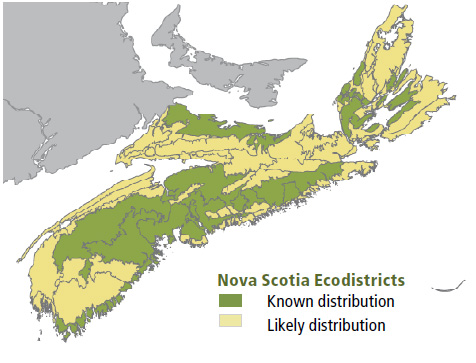
Environmental Setting: Soils are usually organic deposits or poorly drained mineral soils, of varying texture. Low ground and surface water flow and poorly-decomposed organic material limit nutrient availability, but some sites provide at least moderate soil richness. Flats, shallow depressions and lower topographic positions of gentle slopes provide suitable habitat across lowland and upland ecoregions of Nova Scotia. Microtopography, surface stoniness and exposed bedrock are minimal. WD2 is common on Prince Edward Island and across south and central New Brunswick.
Successional Dynamics: This early to mid-successional ecosystem is a type of edaphic climax, largely maintained by saturated soil and reduced rooting potential. It is expected to persist as described, but after disturbance, it could transition to WD8 (Red spruce – Red maple / Wood sorrel – Sensitive fern / Sphagnum) or, on better sites, WD7 (Balsam fir – White ash / Cinnamon fern – New York fern / Sphagnum). Windthrow and harvesting are the main stand-level disturbance agents but in their absence, mortality of individuals and patches of trees through senescence, ice scour, flooding and/or other minor events, can create uneven-aged stands.
Ecological Features: WD2 is the most common deciduous wet forest in Nova Scotia. It is found in small to moderate sized basins or depressions, usually featuring small pools or narrow channels of standing or slowly moving water. Sites rarely support notable microrelief, and trees on those with more pronounced surface topography are often limited to hummocks. This is a moderately productive ecosystem, but few rare plants, other than black ash, are documented. Similar to other wet deciduous forests, WD2 supports unique habitat values (e.g. as an important early source of nectar and pollen), complex stand structures, and important biogeochemical and landscape functions. Wet deciduous forests generally occur on sites that are richer than mixedwood or coniferous wet forests, but some exceptions occur. Canopy tree senescence and uprooting are relatively common and are often followed by vigourous stump sprouting. This process may support a uniquely persistent and poorly understood form of old growth.
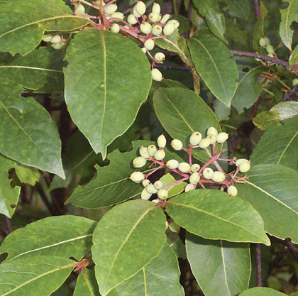 |
| Wild raisin |
Distinguishing Features: Red maple dominates this poorly drained hardwood forest. Cinnamon fern is well developed in the understory. The shrub and herb layers are poorly developed and contain species of low nutrient requirement. This shrub/herb layer difference helps separate WD2 from WD3.
| Slope Position: | Level7 Depression1 Middle1 Upper1 |
Surface Stoniness: |
(Non - Slightly)8 (Very - Excessively)2 |
Bedrock Outcrop: |
(Non-rocky)10 |
Elevation Range: |
18 - 195m |
Slope Gradient: |
Level8 Gentle2 |
Aspect: |
North1 West1 None8 |
Exposure: |
Moderate4 Mod. exposed4 Exposed1 Mod. sheltered1 |
Microtopography: |
Level6 Slightly3 Strongly1 |
Drainage: |
Poor6 Imperfect3 Very poor1 |
Soil Type: |
ST145 ST71 ST121 nd3 |
Parent Material: |
Organic6 Glacial till1 Lacustrine1 Till/Bedrock1 nd1 |
Rooting Depth (cm): |
(<30)1 (30-45)1 (>45)3 nd5 |
Duff Thickness (cm): |
(0-5)1 (11-20)1 (>40)4 nd4 |
![]()