
Highway 101 Digby to Marshalltown Corridor
Project Description
The Department of Transportation and Infrastructure Renewal (TIR) has finalized plans for the Highway 101 Digby to Marshalltown Corridor.
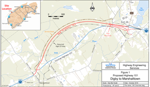
Construction of the Highway 101 Digby to Marshalltown corridor is the first phase of the future Highway 101 controlled access corridor from Digby, at Exit 26, to Weymouth North, at Exit 27. This is the only segment of the 300 kilometre-long Highway 101 that has not been upgraded to a 100-series controlled access standard.
The new Digby to Marshalltown corridor will include a 4 kilometre long highway from Digby, at Exit 26, to Marshalltown, the reconstruction of two ramps at Exit 26, a trail structure (bridge) over Highway 101 for the designated-trail near Exit 26 and an at-grade interchange near Middle Cross Road and the existing Highway 101. A realignment of the existing Highway 101 between Middle Cross Road and Maud Lewis Lane is also included. The new highway will be a controlled access facility built as a 2-lane minor arterial with 3.7 metre wide lanes.
Adjacent properties north of the corridor will be given access, where necessary, by a parallel gravel road constructed at the edge of the right-of-way.
The current section of Highway 101 between Digby and Marshalltown is classified as a Major Arterial highway with a posted speed of 90 km/hr. This section includes intersections with local roadways and many driveways. These points of access slow traffic flow. In addition, a heterogeneous mix of local and through traffic encountered on Highway 101 impedes the efficient movement of goods and people. This results in a lower level of service. Bypassing the existing Highway 101 will separate high speed through traffic from slower speed local traffic, thus decreasing travel times and increasing safety.
The new Highway 101 Digby to Marshalltown Corridor will directly connect Digby with the rural community of Marshalltown. This new roadway will be classified as a controlled access Freeway with a posted speed of 100 km/hour. The only access permitted to a Freeway is at the interchanges, which are designed so that vehicles using the interchange ramps have minimal effect on the traffic using the Freeway.
Background
Planning work on this section of Highway 101 began in 1992. Environmental screening, costing and a traffic study analysis was used to determine the best functional design. The results of environmental investigations also helped define measures to be taken to eliminate and minimize environmental impacts.
An environmental assessment report was completed in 2000 with updates in 2003 and 2016. Topographical information was collected in 2007 and 2015. Public consultations were conducted in 1992 and 1999. Since 1999, the Department has conducted numerous meetings with local residents, stakeholders and public representatives regarding the project. Public consultations provide information to the public, identify any issues that may be outstanding, and give the public an opportunity to discuss their concerns with Department staff.
The project supports the following outcomes:
- Effectively manage traffic volume,
- Reduce travel time for users of the existing highway network
- Improve safety by reducing emergency response times to communities at ends of the project
- Extending the life of the existing asset, specifically the existing Highway 101 and roads connecting to the highway system,
- Improve safety for trail users and motorists by constructing a bridge over the existing and new section of Highway 101
Construction is scheduled to begin in 2017, starting with a watercourse structure over Seely Brook, a recreational trail bridge over Highway 101 and placement of sub-base material for the roadway sections. Paving is scheduled for 2018, with an anticipated completion and opening date of October 2018.
This project was approved for Federal/Provincial cost sharing. The total estimated project cost is $17 million.