
Airborne Synthetic Aperture Radar
DP ME 7, Version 2, 2006. Airborne Synthetic Aperture Radar (SAR) Images Covering 11D, 11E/01, 11E/02, 11E/03 and 11E/04, (25 m x 25 m Resolution).
Abstract
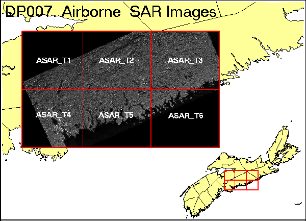
This data set consists of 6 black and white TIFF files with a resolution of 25 m X 25 m covering the eastern Meguma Terrain (11D, 11E/01, 11E/02, 11E/03 and 11E/04). The images are the product of work done by Synmap Technologies under contract to NSNR&R. The images are derived from airborne synthetic aperture radar (SAR) data. Each of the six TIFF files contains three images, one SAR image and two shaded relief images. The images have been georeferenced for use in ArcView. A report by Synmap, Airborne SAR Data Processing and Analysis report, is supplied with this document. Not all of the images indicated in the report are included as part of this product. The ASAR_T1 to T6 images are included using new file names. The image planes are described below. AR_025_T1.TIF to AR_025_T6.TIF: image plane 1 - SAR grey level image plane 2 - shaded relief - azimuth 335 / altitude 35 image plane 3 - shaded relief - azimuth 022 / altitude 30.
Disclaimer
The DATA is provided to the USER on an "as is" basis, without warranties of any kind, express or implied. The entire risk as to the quality and accuracy of the DATA is with the USER and the USER shall use his/her own judgment in making use of the DATA or drawing conclusions based upon it. NR&R shall not be liable to the USER, his/her clients, servants, agents, contractors, assigns, or to any other person for any loss or damage of any kind including personal injury or death arising from the use of the DATA or accompanying written materials, or from errors, deficiencies or faults therein, whether such damage is caused by negligence or otherwise. If errors or omissions are found in the DATA, the USER will notify NR&R. The terms and conditions of the license accompany the downloaded digital product.
Format
Tag Image File Format (TIFF) and TXT files compressed in self-extracting EXE/ZIP files (more information on data formats)
Size
TIFF - 2.1 to 8.1 MB (compressed), 8.9 to 10.0 MB (uncompressed)
Projection
The data is in six-degree Universal Transverse Mercator (UTM) projection, Zone 20, Central Meridian 63° 00' West using the North American Datum of 1983 (NAD83).
Downloading Instructions
The data files have been compressed using PKZIP into a single, self-extracting EXE file.
- Read the Licence before accepting the data.
- Download the self-extracting EXE file to the desired location on your hard drive.
- Double click or "RUN" the EXE file and the data files will be unzipped automatically.
The EXE file can also be opened in WinZip to view and extract the compressed files in the data set.
On UNIX platforms, the unzip command will extract the compressed files in the EXE.
All data sets are in six-degree Universal Transverse Mercator (UTM) Zone 20 projection using the NAD83 datum. A readme file and a copy of the licence agreement are also included with each data set.