
Land-use Planning

Providing space for the co-existence of various land uses takes planning, particularly in an urban environment where competition for land use is more intense than in rural areas. The earth′s surface is the common thread that links land uses. All of the solid materials found at the Earth′s surface and below it are collectively called the Earth′s geology, therefore land-use activities have a direct interaction with geology. Careful consideration to the geological world during land-use planning will ensure minimum property damage and preserve necessary resources.
The Geological Services Division of the Department of Natural Resources (NR&R) is the provincial government agency tasked with the collection, analysis, interpretation and dissemination of the geological data to land-use planners. The Mineral Resources Branch has bedrock and surficial geology maps that can be useful when allocating land uses. For example, finding the ideal locations for new homes where the material can easily be excavated without costly blasting, the soil is impermeable for septic systems and the terrain is stable and not subject to slope failures. The Mineral Resources Branch Land Use Atlas is a collection of interpreted geology maps showing relevant land opportunities and constraints for development.
Many geologic conditions are associated with public health and safety and can cause significant harm to communities if geology is not incorporated in land-use decisions. Common geohazards in Nova Scotia include: flooding, coastal erosion, landslides, and acid rock drainage.
The province has mapped areas with unstable ground including abandoned mines, coal mine subsidence, and sinkholes). The Mineral Resources Branch also provides information about harmful heavy metals (https://novascotia.ca/natr/meb/pubs/pubs3md.asp), radon gas, and arsenic.
Regional geology greatly influences the quantity and quality of water supplies. Dissolved minerals can influence the taste and colour of drinking water. The location and type of well influences the quantity of available supplies. The Mineral Resources Branch has useful information regarding water resources.
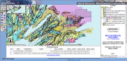
Mineral Resource Land-Use Atlas
Municipal Climate Change Action Plans
Land Planning