
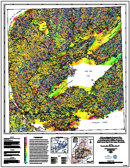
Airborne Magnetics for South-Central Cape Breton Island, Nova Scotia
DP ME 62, Version 2, 2006. Airborne Magnetic Total Field, Calculated First Vertical Derivative and Calculated Second Vertical Derivative Images for NTS 11F/10, 11F/11, 11F/14, 11F/15, 11K/02 and 11K/03, Part of the TGI Project Area, South-Central Cape Breton Island, Nova Scotia
Abstract
The data used to generate these images and maps were supplied by the Geological Survey of Canada - Geophysical Data Centre, 615 Booth St., Ottawa, Ontario, K1A 0E9, and the Radiation Geophysics Division, 601 Booth St., Ottawa, Ontario, K1A 0E8. The original magnetic data were acquired as part of Project #260 "Western Cape Breton Island" and the "Bras d'Or Survey". These digitally acquired data were locally augmented by analogue data, which comprise less than 5% of the survey area. The MAGNETIC TOTAL FIELD images (and other subsequent images) were derived from the levelled and decorrugated measured total field response. The ENHANCED MAGNETIC DATA (First and Second Vertical Derivative) images enhance near-surface magnetic sources at the expense of deeper features and should correlate most closely with geological map information.
Spatial resolution of the images is approximately 75 m. The 24-bit colour map images were produced with a 25 m pixel size. Shading was from the southeast at 35° above the horizon.
Disclaimer
The information on the PDF map comes from a variety of government and non-government sources. NSNR&R accepts no liability for any errors or deficiencies on this map. This map should not be used for legal purposes.
The PDF map is intended for use at the published scale of 1:50 000.
The DATA is provided to the USER on an "as is" basis, without warranties of any kind, express or implied. The entire risk as to the quality and accuracy of the DATA is with the USER and the USER shall use his/her own judgment in making use of the DATA or drawing conclusions based upon it. NR&R shall not be liable to the USER, his/her clients, servants, agents, contractors, assigns, or to any other person for any loss or damage of any kind including personal injury or death arising from the use of the DATA or accompanying written materials, or from errors, deficiencies or faults therein, whether such damage is caused by negligence or otherwise. If errors or omissions are found in the DATA, the USER will notify NR&R. The terms and conditions of the license accompany the downloaded digital product.
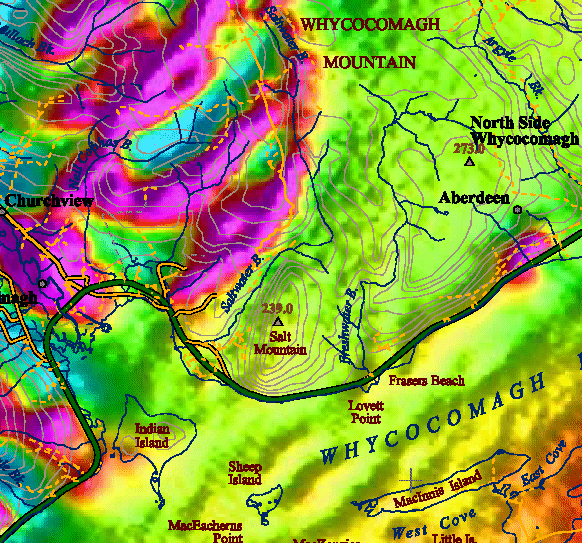
A Sample Image of One of the PDF Maps
(Sample image - Click to view details in a smaller area )
Format
Portable Document Format (PDF), Tag Image File Format (TIFF), Joint Photographic Experts Group (JPEG) and TXT files compressed in self-extracting EXE/ZIP files (more information on data formats)
Size
PDF - 2.3 to 20 MB(compressed and uncompressed)
TIFF - 5.3 to 10.4 MB (compressed), 24.3 to 112.5 MB (uncompressed)
JPEG - 1.4 to 2.4 MB (compressed), 1.5 to 2.5 MB (uncompressed)
Projection
The TIFF and JPEG images are in six-degree Universal Transverse Mercator (UTM) projection, Zone 20, Central Meridian 63° 00' West using the North American Datum of 1983 (NAD83).
The PDF maps are are in six-degree Universal Transverse Mercator (UTM) projection, Zone 20, Central Meridian 63° 00' West using the North American Datum of 1983 (NAD83).
Downloading Instructions
The data files have been compressed using PKZIP into a single, self-extracting EXE file.
- Read the Licence before accepting the data.
- Download the self-extracting EXE file to the desired location on your hard drive.
- Double click or "RUN" the EXE file and the data files will be unzipped automatically.
The EXE file can also be opened in WinZip to view and extract the compressed files in the data set.
On UNIX platforms, the unzip command will extract the compressed files in the EXE.
All data sets are in six-degree Universal Transverse Mercator (UTM) Zone 20 projection using the NAD83 datum. A readme file and a copy of the licence agreement are also included with each data set.