
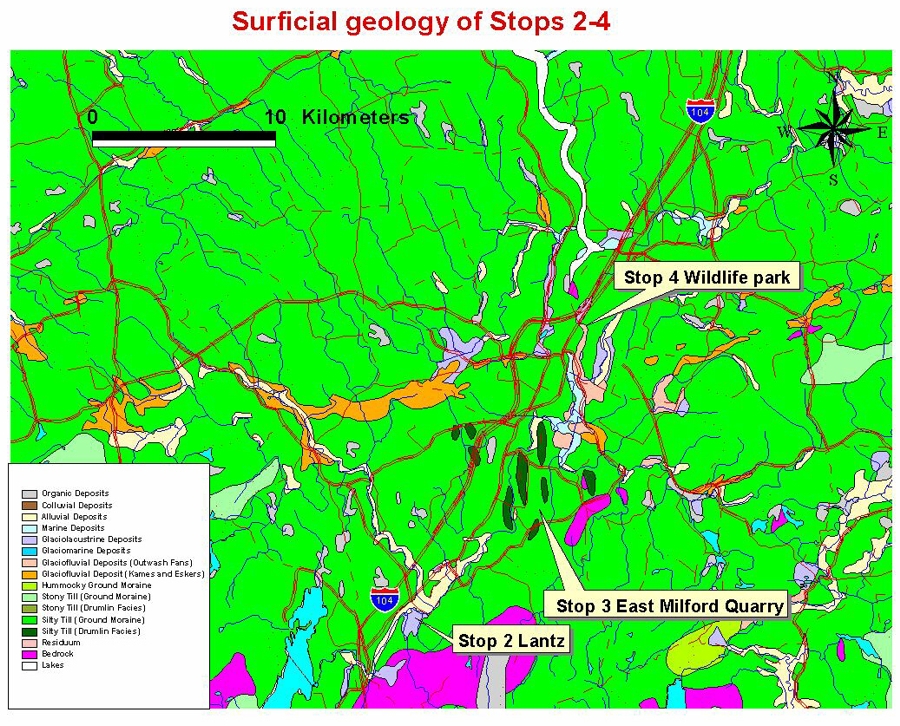
Stop 4: Shubenacadie Wildlife Park: Shoreline Deposits of Glacial Lake Shubenacadie
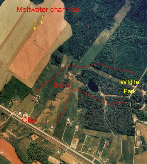
We have a short flight to the Shubenacadie Wildlife Park near the town of Shubenacadie, where in addition to the incredible geology you can see indigenous Nova Scotia wildlife. The surrounding area is a gently rolling till plain with drumlins that reach elevations of 66 m above mean sea level. Sand and clay deposits are generally found in low-lying areas below 30 m elevation. Meltwater channels that emanated from former glaciers can be seen on the air photos (above) and these end at the former shoreline of Glacial Lake Shubenacadie (marked by sand deposits).
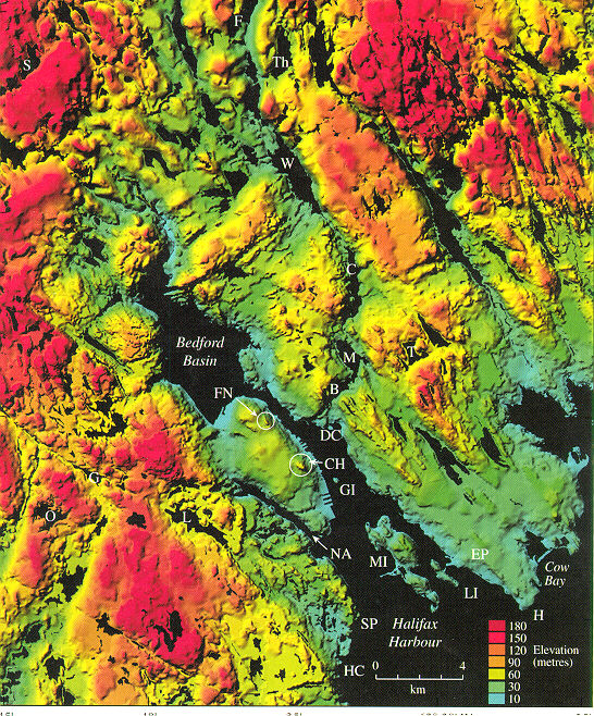
Summary for non-geologists: The wildlife park is located in a valley filled with sand and gravel. These are shoreline or beach deposits of Glacial Lake Shubenacadie (see Stop 3). This glacial lake filled the Shubenacadie valley and surrounding lowlands to depths of approximately 30 m. It was formed when advancing and retreating glaciers dammed the present outlet of the Shubenacadie River in the Minas Basin. Rather than draining northward, the glacial lake drained southward through the route of the Shubenacadie canal system into Halifax harbour.
Note: For more info read Stea and Mott, 1989; Mott and Stea, 1994; Stea and Mott, 1998.
Car people! Exit the National Gypsum Quarry road and turn right on Highway 2. Pass through the village of Shubenacadie (Mik'maq word for place where wild potatoes grow) and cross the Shubenacadie River. The wildlife park is on the right. See location map.
Stratigraphy and Chronology

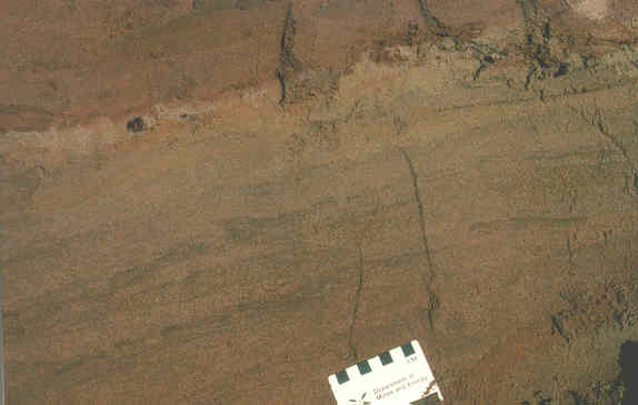
Photograph of the shoreline of Glacial Lake Shubenacadie looking west. (The person is standing in a meltwater channel that terminates in glaciolacustrine sand filling the valley below). Hydrogeologist Terry Hennigar first noticed buried peat under thick deposits of sand in 1969 while looking for a groundwater supply for the wildlife park. Owen Hughes (1957) had previously mapped the local sand deposits as proglacial outwash. The sand deposits are confined to a small valley that runs through the park.
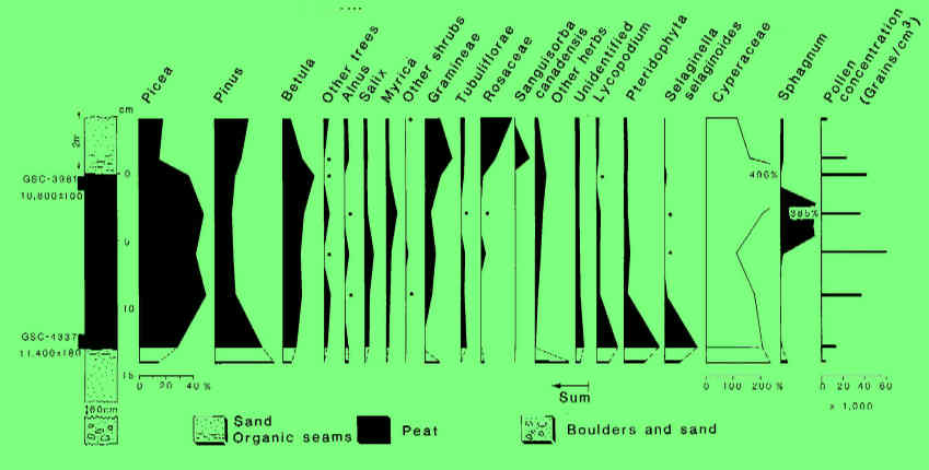
In 1992 the Department of Natural Resources drilled through the sand deposits in the vicinity of the photo to the left. The stratigraphic section shows a 25 m thick brown plastic silty clay which underlies the valley. Overlying the clay is moderately sorted, coarse to fine sand. A continuous layer of fibrous, sedge-moss peat overlies the sand unit at an average depth of 2 m below surface. Radiocarbon dates of 11.4 ka (GSC-4337)and 10.8 ka (GSC-3981) were obtained from the base of the peat. Overlying the organic layer to the surface is a moderately sorted sand unit characterized by parallel, horizontal layering of coarse and medium sand.
Pollen Analysis
Pollen grains were recovered from the peat and from organic sand immediately below and above it (See pollen diagram). Basal assemblages are characterized by high levels of Cyperaceae (sedge) and abundant herb pollen and spores of Lycopodium (club moss), Pteridophyta (ferns), and Selaginella selaginoides. Pinus (pine) pollen may be over-represented, due to its capability for long distance transport. Picea (spruce) levels increase above the base of the peat and exceed 40%. Betula (birch) levels also increase slightly up-section along with other shrub taxa, whereas Cyperaceae and herb and spore percentages decline. Sphagnum abundances reach high values near the top of the peat. In the sand unit above the peat bed, Picea levels decline abruptly, Betula (probably shrub birch) increases somewhat and Cyperaceae increases greatly.
Interpretation
The basal clay encountered in boreholes at Shubenacadie is interpreted to be a glacial lake deposit and correlative with the basal brick clay at Lantz (see Stop 3). Shallow ponds and wet sedge meadows characterized the Shubenacadie site when the glacial lake drained and the river occupied the valley after 11.4 ka. Ferns, club mosses, Selaginella and a variety of herbs became locally abundant. Birch, willow and other shrubs bordered the wet areas. Spruce invaded the area early and open woodlands occupied suitable sites on the landscape surrounding the wetlands until about 11 ka. Following this time, spruce declined in abundance and birch, grasses and herbs increased as a glacier advanced and a second glacial lake drowned the area.
The Shubenacadie sand deposit is one of the sand bodies flanking the Shubenacadie River that was mapped as outwash by Hughes (1957). The Shubenacadie deposit lies above the floodplain of the Shubenacadie River and extends to near the crest of the adjacent slopes to an elevation of 20 m. Most sand bodies lie on the eastern side of the Shubenacadie River at elevations up to 30 m. Some of them are distal to esker systems and have a deltaic structure with northwestward-dipping foreset beds (Hughes, 1957). The normally graded coarse to medium sand beds within the Shubenacadie deposit suggest a lacustrine origin. Eolian deposits (i. e. sheet sands) may have similar grain sizes, but are generally better sorted and do not have a strict elevational control. A glaciofluvial origin is unlikely because of the lack of coarser gravel beds. A circular pond that marks the upper reaches of the sand body (see photo) is probably a sinkhole. The most consistent interpretation is that this sand body developed along the shoreline of a glacial lake (Glacial Lake Shubenacadie 2) fed by meltwater streams from a glacier to the east. The lake re-formed in the Shubenacadie Valley after drainage of the former, larger glacial lake (Glacial Lake Shubenacadie 1). These ice-dammed lakes formed when normal drainage via the Shubenacadie River toward the Bay of Fundy was blocked by residual or re-advancing glaciers during the Younger Dryas climatic event. See reconstruction.
Go back to the chopper (virtual field trip home page) or