
About Radon in Indoor Air Summary Statistics
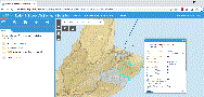
Online Interactive Map for Viewing Community Level Radon in Indoor Air Summary Statistics
This application provides community level summary statistics of radon concentrations in the Province of Nova Scotia, indicating areas of the province that are susceptible to elevated radon and the likelihood of radon exceeding Health Canada's guideline of 200 Bq/m3 in indoor air.
Using radon measurements from over 4500 unique buildings in Nova Scotia, the map provides statistical summaries of radon levels in 'community environs'. These geographical units were developed to represent clusters of populations, and neighbourhoods that share some degree of identity and social cohesion (Saint-Jacques, 2019). The map colour scheme highlights the degree of data clustering in each environ to show the representativeness of available data.
Descriptions of the methods used to develop the map, and a more detailed analysis of the results, are provided in the report Community-level summary statistics of measured radon in indoor air for the Province of Nova Scotia. The analysis showed that more than 20% of the buildings surveyed across Nova Scotia had at least one room where average radon was measured at levels exceeding the safe limit for radon in indoor air. Analysis of the data also showed that radon concentrations can vary widely within a community, and elevated radon occurs throughout the province, highlighting the importance of testing all homes for this invisible gas, regardless of geographic location. Nova Scotia's radon potential map can be accessed here and more information on radon testing can be found here.
RELATED PRODUCTS