Sinkholes
Online Interactive Karst Risk Maps
Report on Nova Scotia Karst Risk Map

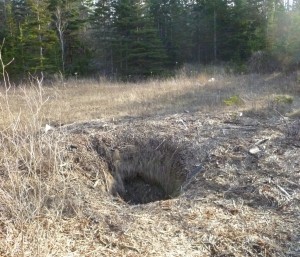
Two metre wide sinkhole near Cheverie, Nova Scotia.
A sinkhole is a natural depression or hole in the Earth's surface which may have various causes. Most natural sinkholes are caused by the chemical dissolution of water soluble carbonate rocks or gypsum. Sinkholes may vary in size from 1 to 600 m both in diameter and depth. Sinkholes may be formed gradually or by sudden collapse, and are found worldwide in karst areas. The term "sinkholes" has also been used to describe ground subsidence caused by anthropogenic activities, for example the collapse of old mine workings close to the surface, also known as abandoned mine openings.
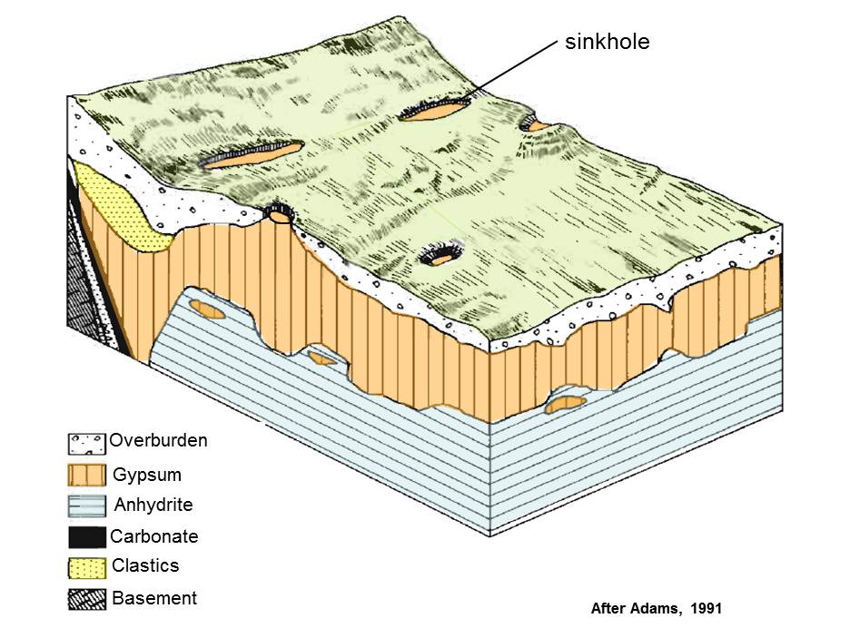
 Generalized model for karst topography and sinkhole development in Nova Scotia.
In Nova Scotia most natural sinkholes or karst topography are formed over areas where Windsor Group gypsum occurs in the near surface. The geological boundary between the gypsum- and salt-bearing Windsor Group and the underlying sandstones and shales of the Horton Group or older basement rocks is particularly prone to sinkhole development.
In areas of sinkhole development the primary geohazard is related to sudden catastrophic subsidence due to collapse of cavities in the bedrock created by the dissolution of the gypsum and/or limestone. Caution should be exercised in these areas prior to construction of buildings or roads.

Reducing Karst Risks
Karst landscape is not unique to Nova Scotia, it occurs over about a quarter of the earth’s surface. As a result, there are well-established methods for reducing karst risks. These include actions that can be taken both at the planning and construction stage of a project, as well as on-going actions that reduce the risk of future sinkhole formation.
At the planning stage of a project, risks can be reduced by investigating the karst potential of a site, assessing the risk, and determining appropriate mitigation measures. A common approach is to begin the investigation with a preliminary site visit and desktop study that reviews available information such as geology maps, karst risk maps, known sinkhole locations, water well and borehole records, air photos, lidar, and relevant geological reports for the area. This is followed by a ground investigation that includes both non-intrusive work (e.g., geophysical survey methods such as ground penetrating radar, electrical resistivity, seismic, gravity) and intrusive work (e.g., drilling, trenching). Investigations should be carried out by qualified persons who are licensed to practice in Nova Scotia, such as professional geoscientists (https://www.geoscientistsns.ca/) or engineers (https://engineersnovascotia.ca/).
Mitigation methods are available if a site is determined to have unacceptable karst risks. Examples of mitigation methods include avoiding areas where underground cavities or voids in have been identified, stabilizing the soil above the bedrock (e.g., grouting, soil compaction), and repairing existing sinkholes and bedrock fissures (e.g., with concrete, engineered granular fill). The construction methods available to mitigate karst risks depend on the type of development being considered (e.g., housing, highways, railways, etc.). For example, buildings can be protected using driven piles, reinforced concrete foundations, and extended foundations that can span a sinkhole. Underground services (e.g., water, sewer, electricity, gas, etc.) can be run on reinforced sections of the foundation and made of flexible construction to reduce the risk of damage. This is especially important for water and sewer lines to prevent leaks that can increase the risk of subsidence.
It is important to note that 90% of new sinkholes in populated areas are induced by human activity. The two main causes of human-induced sinkholes are water table decline and changes to water drainage patterns. Avoiding or limiting these activities can reduce the risk of future subsidence. Excessive groundwater pumping from water wells in karst areas can lower the water table, which increases the depth of vertical drainage in the soil above the bedrock. The increased vertical drainage promotes soil erosion and transport in the subsurface, leading to void development and subsidence. Any changes to natural surface water run-off and infiltration patterns can lead to localized increases in water input, which increases the risk of sinkhole development. Surface water run-off from houses, roads, parking lots, and other developments should be piped away to established surface water drainage pathways.
For individual houses and small developments, it may not be practical to carry out the site investigations and ground stabilization methods described above. In these cases, the most practical approach may be to avoid actively subsiding areas, use reinforced foundations during construction, and to avoid the concentration of surface water run-off and infiltration near buildings.
What to do if you see a sinkhole
If you see a sinkhole that is affecting public safety or public property, consider contacting your local municipal government office. They may re-direct you if the property is owned by the provincial or federal government. If the sinkhole is affecting a pubic road, contact the Department of Transportation and Infrastructure Renewal (for provincial roads) or your local municipality (for municipal roads). If you find a sinkhole on your property, consider the following actions:
- Keep a safe distance from the sinkhole.
- If possible, put a barrier around the sinkhole for safety reasons (e.g., caution tape, rope, etc.).
- Contact your insurance company.
Further Information
Report on Nova Scotia’s karst map
(https://novascotia.ca/natr/meb/data/pubs/19ofr01/ofr_me_2019-001.pdf)
Geology maps of Nova Scotia (https://novascotia.ca/natr/meb/geoscience-online/maps-gallery.asp).
Avoiding gypsum geohazards: guidance for planning and construction (http://nora.nerc.ac.uk/id/eprint/14146/1/Cooper_Callow_1998_DIFID_Gypsum_and_planning_WC_98_005_COL.pdf).
Sinkholes and Subsidence; Karst and Cavernous Rocks in Engineering and Construction (Waltham et al., 2005) (this book is available at the NS Natural Resources and Renewables library).