
Airborne Gamma Ray Spectromatric Survey Images
DP ME 5, Version 2, 2006, Airborne Gamma Ray Spectrometric Survey Images, Elemental and Elemental Ratio Images Covering 11D, 11E, 11F, 11G, 11J, 11K, 11N, 20O, 20P, 21A, 21B and 21H, (250 m x 250 m resolution).
Abstract
This data set consists of 24 colour TIFF images with a resolution of 200 m X 200 m covering 12 1:250 000 NTS mapsheets, where airborne gamma ray surveys exist over Nova Scotia. Twelve of the TIFF images represent the radioelements for the entire province, while the other twelve represent the ratios of the radioelements values. The original data were collected by aeromagnetic surveys flown by the Geological Survey of Canada (GSC). rd_250_xxx.tif Series: Band 1: %K - Potassium Band 2: eU - equivalent Uranium Band 3: eTh - equivalent Thorium rr_250_xxxx.tif Series: Band 1: eU/%K - equivalent Uranium/Potassium Band 2: eTh/%K - equivalent Thorium/Potassium Band 3: eU/eTh - equivalent Uranium/equivalent Thorium. These are the .tiff images showing ratios of radiometrics values for the entire province.
Disclaimer
The DATA is provided to the USER on an "as is" basis, without warranties of any kind, express or implied. The entire risk as to the quality and accuracy of the DATA is with the USER and the USER shall use his/her own judgment in making use of the DATA or drawing conclusions based upon it. NR&R shall not be liable to the USER, his/her clients, servants, agents, contractors, assigns, or to any other person for any loss or damage of any kind including personal injury or death arising from the use of the DATA or accompanying written materials, or from errors, deficiencies or faults therein, whether such damage is caused by negligence or otherwise. If errors or omissions are found in the DATA, the USER will notify NR&R. The terms and conditions of the license accompany the downloaded digital product.
A Sample Image

Radiometrics based on NTS 1:250 000 map sheets
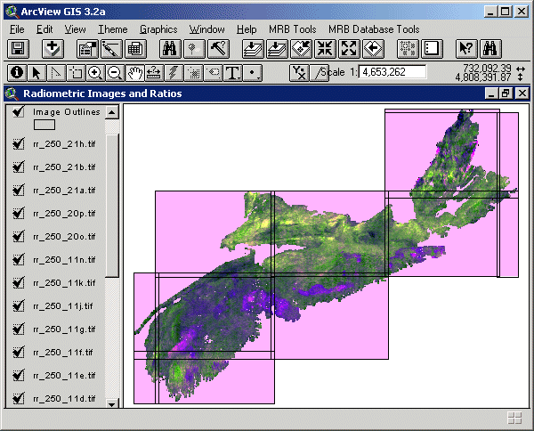
Ratio of radiometrics based on NTS 1:250 000 map sheets
Format
Tag Image File Format (TIFF) and TXT files compressed in self-extracting EXE/ZIP files (more information on data formats)
Size
TIFF (12 Elemental Images) - 2.6 MB (compressed), 6.7 Mb (uncompressed)
TIFF (12 Elemental Ratio Images) - 2.2 MB (compressed), 6.7 Mb (uncompressed)
Projection
The data is in six-degree Universal Transverse Mercator (UTM) projection, Zone 20, Central Meridian 63° 00' West using the North American Datum of 1983 (NAD83).
Downloading Instructions
The data files have been compressed using PKZIP into a single, self-extracting EXE file.
- Read the Licence before accepting the data.
- Download the self-extracting EXE file to the desired location on your hard drive.
- Double click or "RUN" the EXE file and the data files will be unzipped automatically.
The EXE file can also be opened in WinZip to view and extract the compressed files in the data set.
On UNIX platforms, the unzip command will extract the compressed files in the EXE.
All data sets are in six-degree Universal Transverse Mercator (UTM) Zone 20 projection using the NAD83 datum. A readme file and a copy of the licence agreement are also included with each data set.