
Shaded Relief Images of Nova Scotia (25 m)
DP ME 56, Version 2, 2006. Shaded Relief Images Derived from a 25 Metre Digital Elevation Model of the Province of Nova Scotia, Compiled by B. E. Fisher, J. C. Poole and J. S. McKinnon.
Abstract
The digital product contains 48 shaded relief images that are each provided in MrSID format. These images are produced from a 25 meter gridded Digital Elevation Model (DEM) with the sun shining along 8 different azimuths (0, 045, 090, 135, 180, 225, 270, 315) at 3 different altitudes (30°, 45°, 60°). The images were produced with two different vertical exaggerations (5 and 10). The shaded relief images were derived from an Enhanced Digital Elevation Model provided by the Nova Scotia Geomatics Cent er (see cross reference 1 for DP ME 55). The Mineral Resources Branch has produced a number of shaded relief images in JPEG and MrSID format for the province, gridded at 100 metres (DP ME 57), which can be downloaded for free as digital product DP ME 57. MRB has produced a map (OFM ME 2004-1) that shows how the shaded relief images contained in DP ME 56 and DP ME 57 were created and provides an example of the effect of changes in azimuth and altitude on the appearance of the image. This map can be downloaded for free as digital product DP ME 105. Metadata about the DEM used to create DP ME 56, 57 and 105 can be downloaded as digital product DP ME 55.
Disclaimer
The information on these images may have come from a variety of government and non-government sources. The Nova Scotia Department of Natural Resources does not assume any liability for any errors that may occur.
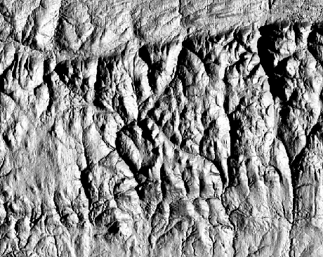
A Sample MrSID Image
Sample image -
Click to view details in a smaller area
)

Format
MrSID (SID) images and TXT files compressed in self-extracting EXE/ZIP files (more information on data formats)
Size
MrSID-7.8 MB to 8.8 MB (compressed) and 10.2 MB to 11.1 MB (uncompressed)
Projection
The MrSID images are in six-degree Universal Transverse Mercator (UTM) projection, Zone 20, Central Meridian 63° 00' West using the North American Datum of 1983 (NAD83).
Downloading Instructions
The data files have been compressed using PKZIP into a single, self-extracting EXE file.
- Read the Licence before accepting the data.
- Download the self-extracting EXE file to the desired location on your hard drive.
- Double click or "RUN" the EXE file and the data files will be unzipped automatically.
The EXE file can also be opened in WinZip to view and extract the compressed files in the data set. On UNIX platforms, the unzip command will extract the compressed files in the EXE.