
VLF-EM Images for Central Nova Scotia
DP ME 123, Version 2, 2006. Airborne VLF-EM Line Total Field Images Collectively Covering Parts of NTS Sheets 11E/02 and 11E/07, TGI-2 Project, Central Nova Scotia
Related Products
... DP ME 113
Abstract
This data set consists of one TIFF, one JPEG image, and one PDF Open File Map (2005-101) of airborne VLF-EM line total field data covering an area in central Nova Scotia which is part St. Marys Basin TGI-2 project.
This digital product was derived from data collected by the Geological Survey of Canada (Survey#
184). For these images only the levelled and de-corrugated Line
(Tx: Annapolis, Md) total field data was used.The 24-bit colour
images were produced with 10m pixel sizes. Shading was from the
southeast at 35 degrees above the horizon. For complete details
an Open File Report will be forthcoming from M. S. King later
in 2004.
The images were produced by contractor M. S. King using funds
provided under the Natural Resources Canada and Nova Scotia Department
of Natural Resources joint project 'Mapping, Mineral and Energy
Resource Evaluation, Central Nova Scotia', part of Natural Resources
Canada's Targeted Geoscience Initiative (TGI-2) 2003-2005.
Disclaimer
The information on these maps
and images may have come from a variety of government and non-government
sources. The Nova Scotia Department of Natural Resources does
not assume any liability for any errors that may occur.
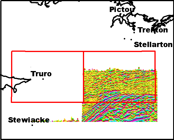
A Sample VLF-EM Image
(Sample image -
Click to view details in a smaller area
)
Format
Portable Document Format (PDF), Tag Image File Format (TIFF), Joint Photographic Experts Group (JPEG) and TXT files compressed in self-extracting EXE/ZIP files (more information on data formats)
Size
PDF - 15.3 MB (compressed), 17.4 MB (uncompressed)
TIFF - 8.6 MB (compressed), 59.5 MB (uncompressed)
JPEG - 2.3 MB (compressed), 2.4 MB (uncompressed)
Projection
The TIFF and JPEG images are in six-degree Universal Transverse Mercator (UTM) projection, Zone 20, Central Meridian 63° 00' West using the North American Datum of 1983 (NAD83).
The PDF maps are are in six-degree Universal Transverse Mercator (UTM) projection, Zone 20, Central Meridian 63° 00' West using the North American Datum of 1927 (NAD27).
Downloading Instructions
The data files have been compressed using PKZIP into a single, self-extracting EXE file.
- Read the Licence before accepting the data.
- Download the self-extracting EXE file to the desired location on your hard drive.
- Double click or "RUN" the EXE file and the data files will be unzipped automatically.
The EXE file can also be opened in WinZip to view and extract the compressed files in the data set. On UNIX platforms, the unzip command will extract the compressed files in the EXE.