Potential for Radon in Indoor Air in Nova Scotia
DP ME 486, Version 1, 2013, Digital Data Showing the Potential for Radon in Indoor Air in Nova Scotia by G. A. O'Reilly, T. A. Goodwin, J. S. McKinnon, B. E. Fisher. |
|||||||
|
Related Products |
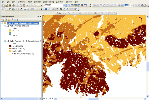
AbstractRadon (Rn) is a naturally occurring, colourless and odourless gas that is radioactive and known to cause lung cancer. In fact, Rn is the second leading cause of lung cancer after smoking and the leading cause of the disease among nonsmokers (World Health Organization, 2009). Radon is generated naturally from the radioactive decay of uranium. Both elements are found in varying amounts in all the soils and rocks throughout the province (Goodwin et al., 2009, 2010a). A GIS-based (Geographic Information System) approach was used to produce this dataset and open File map 2013-028. Using a GIS model to produce a dataset of this sort requires coverage of the study area in digital information layers of bedrock geology, surficial/soil geology and airborne gammaray spectrometry for eU (equivalent uranium). Coverage of the study area by indoor Rn measurement surveys is also necessary in order to test the validity of the GIS model and to determine exceedence probability percentages. Nova Scotia, more so than any other Canadian province or territory, benefits by having total provincial coverage in all these digital data layers and is, thus, a prime candidate for createing this derived digital product. The derivation and running of the GIS model are explained in more detail in O'Reilly et al. (2010). Basically, the GIS model brings together the three digital information layers and integrates the characteristics of each that pertain to its potential for the generation of Rn and for allowing the gas to migrate and accumulate within homes. The airborne gamma-ray spectrometric layer provides an estimate of the U concentration (U is the original source of the Rn) of the surface soils and rocks. The bedrock geology layer shows the distribution of each rock unit throughout the province and provides an estimate of each unit's potential to produce Rn. The surficial geology layer provides an estimate of the permeability of the surface material, a factor deemed very important in allowing Rn to travel through the soil to reach a building's foundation. These three data layers are factored against each other in the running of the GIS model and collectively produce a new layer depicting Rn potential score (Rn Score). In our model the three data layers were given an equal weighting. Within each data layer, the potential for each unit constituting that layer to produce Rn was subjectively scored from 1 to 100. As such, following the running of the GIS model, a maximum cumulative Rn score of 300 is possible for any particular area. The GIS model produced a range of cumulative Rn scores from a minimum of 25 to a maximum of 275. It should be noted that areas of water cover produce a Rn score of zero, but since there are no homes or dwellings in water, these areas were ignored. The Nova Scotia Department of Health and Wellness recommends that all homeowners in the province test their homes for Rn. Many Rn studies carried out globally have shown conclusively that, although the percentage of homes exceeding established Rn guidelines can vary from area to area, there are no areas completely devoid of homes with high Rn. No matter where you live, the only way you will know for sure whether or not your home has high Rn is to complete a proper Rn test (Health Canada, 2008). Since there are regions where there are a higher percentage of Rn guideline exceedences, a dataset such as this showing the distribution of these regions is useful in determining priority areas for testing and for assisting with building code guidelines. |
||||||
DisclaimerThe DATA is provided to the USER on an "as is" basis, without warranties of any kind, express or implied. The entire risk as to the quality and accuracy of the DATA is with the USER and the USER shall use his/her own judgment in making use of the DATA or drawing conclusions based upon it. NR&R shall not be liable to the USER, his/her clients, servants, agents, contractors, assigns, or to any other person for any loss or damage of any kind including personal injury or death arising from the use of the DATA or accompanying written materials, or from errors, deficiencies or faults therein, whether such damage is caused by negligence or otherwise. If errors or omissions are found in the DATA, the USER will notify NR&R. The terms and conditions of the license accompany the downloaded digital product. |
|||||||
Detailed View
|
|||||||
Format and Projection
|
|||||||
Downloading InstructionsThe data files have been compressed using PKZIP into a single, self-extracting EXE file.
The EXE file can also be opened in WinZip to view and extract the compressed files in the data set. On UNIX platforms, the unzip command will extract the compressed files in the EXE. All data sets are in six-degree Universal Transverse Mercator (UTM) Zone 20 projection using the NAD83 datum. A readme file and a copy of the licence agreement are also included with each data set. |
|||||||
|
|
|||||||