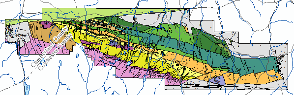
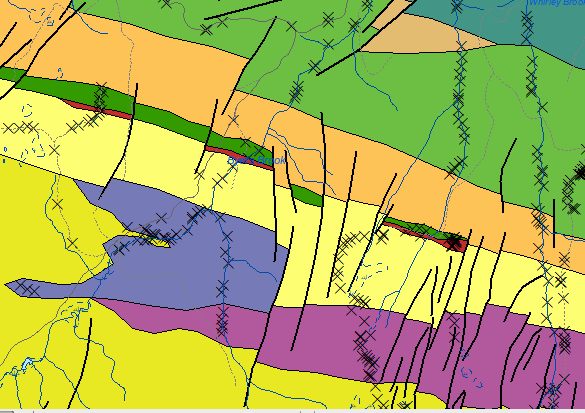
DP ME 504, Version 1, 2018. Digital Version of Nova Scotia Department of Natural Resources Open File Map ME 2018-005, Preliminary Bedrock Geology Map of the Eastern Cobequid Highlands, Nova Scotia, scale 1:35 000, by T.G. MacHattie, 2018. Digital Product by T.G. MacHattie and C.C. MacMullen.
Release Date: March 5, 2018, 10 am EST (11 am AST) |
|
Disclaimer
Location Map
Sample
Format and Projection
Metadata
Download Instructions
Download Digital Data Set
Related Products
OFM ME 2018-005
OFR ME 2018-005
|
Abstract
This digital product is a digital version of Nova Scotia Department of Natural Resources (NSNR&R) Open File Map ME 2018-005, compiled by T.G. MacHattie in 2018. The original data collection was done as part of the Eastern Cobequid Highlands Mapping Project from 2008-2017, and detailed field mapping, petrography, geochemistry and high-precision CA-ID-TIMS zircon geochronology have all been used to define the volcanic stratigraphy, major flow units and associated sub-volcanic intrusive rocks depicted in the preliminary map. The digital product was created by the Nova Scotia Department of Natural Resources, Geoscience and Mines Branch (GMB) staff. The digital product contains layers for geological features such as age dates, faults, bedrock geological units, geological contacts, and small outcrops.
The bedrock geological mapping, along with surficial geological mapping, lithogeochemistry sampling, and silt and till geochemical surveys, was a component of renewed bedrock and mineral deposit research on the epithermal gold potential of the Byers Brook and Diamond Brook formations. |
|
Disclaimer
The DATA is provided to the USER on an "as is" basis, without warranties of any kind, express or implied.
The entire risk as to the quality and accuracy of the DATA is with the USER and the USER shall use his/her own judgment in making use of the DATA or drawing conclusions based upon it.
NR&R shall not be liable to the USER, his/her clients, servants, agents, contractors, assigns, or to any other person for any loss or damage of any kind including personal injury or death arising from the use of the DATA or accompanying written materials, or from errors, deficiencies or faults therein, whether such damage is caused by negligence or otherwise. If errors or omissions are found in the DATA, the USER will notify NR&R.
The terms and conditions of the license accompany the downloaded digital product.
|
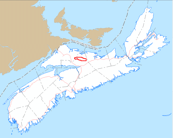
Location Map
|
Overview
|
Detailed View
|
| Format |
ESRI shape files (SHP), ArcGIS File Geodatabase
(GDB) and XLS files
compressed in ZIP files
(more
information on data formats) |
| Size |
SHP/GDB/XLS - 7.4 MB (compressed), 22.8 MB (uncompressed)
|
| Projection |
The data is in six-degree Universal Transverse Mercator (UTM) projection, Zone 20, Central Meridian 63° 00' West using the North American Datum of 1983 (NAD83). |
|
Downloading Instructions
The data files have been compressed using IZArc into a single ZIP file.
- Read the Licence before accepting the data.
- Download the ZIP file to the desired location on your computer hard drive.
- Unzip and extract the data onto your computer. We STRONGLY recommend you unzip our data to a consistent area on your hard drive (e.g. C:\nsDNR\).
All data sets are in six-degree Universal Transverse Mercator (UTM) Zone 20 projection using the NAD83 datum.
A readme file and a copy of the licence agreement are also included with each data set. |
Download Digital Data Set DP ME 504
|
