
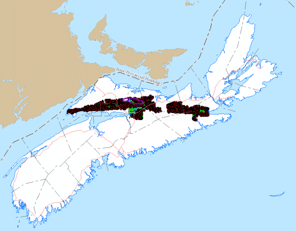
Cobequid-Chedabucto Fault Zone, Gravity Survey
DP ME 509, Version 1, 2018, Ground Gravity Survey, Cobequid-Chedabucto Fault Zone, Northern mainland, Nova Scotia
Abstract
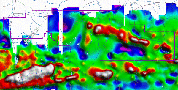
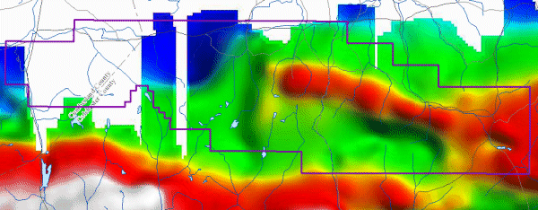
This dataset consists of a SHP file of 11,662 ground gravity stations and JPG images for 1st vertical derivative bouguer gravity and residual gravity over the full length of the Cobequid-Chedabucto Fault Zone in the northern mainland of Nova Scotia.This work was done in 2008 and 2009 by Minotaur Atlantic Exploration Limited and used from 2008 to 2012 as part of mineral exploration work in the area. There were several assessment reports submitted over this period that describe this survey and the results (e.g. AR_ME_2008-18 and AR_ME_2009-010).
The purpose of this data was to find gravity anomalies to assist with mineral exploration work.
Disclaimer
The information on the PDF map comes from a variety of government and non-government sources. NSNR&R accepts no liability for any errors or deficiencies on this map. This map should not be used for legal purposes.
The PDF map is intended for use at the published scale of 1:50 000.
The DATA is provided to the USER on an "as is" basis, without warranties of any kind, express or implied.
The entire risk as to the quality and accuracy of the DATA is with the USER and the USER shall use his/her own judgment in making use of the DATA or drawing conclusions based upon it.
NR&R shall not be liable to the USER, his/her clients, servants, agents, contractors, assigns, or to any other person for any loss or damage of any kind including personal injury or death arising from the use of the DATA or accompanying written materials, or from errors, deficiencies or faults therein, whether such damage is caused by negligence or otherwise. If errors or omissions are found in the DATA, the USER will notify NR&R.
The terms and conditions of the license accompany the downloaded digital product.
Format
ESRI shape files (SHP) and Joint Photographic Experts Group (JPEG) images for the processed data compressed into a ZIP file (more information on data formats)
Size
SHP/JPG Files - 9.5 MB (compressed), 145 MB (uncompressed)
Projection
The data is in six-degree Universal Transverse Mercator (UTM) projection, Zone 20, Central Meridian 63° 00' West using the North American Datum of 1983 (NAD83).
Downloading Instructions
The data files have been compressed using IZArc into a single ZIP file.
- Read the Licence before accepting the data.
- Download the ZIP file to the desired location on your hard drive.
- Unzip and extract the data onto your computer. We STRONGLY recommend you unzip our data to a consistent area on your hard drive (e.g. C:\nsDNR\).
All data sets are in six-degree Universal Transverse Mercator (UTM) Zone 20 projection using the NAD83 datum.