
Stop 12: Lismore: A Section Spanning Late-Glacial Climatic Events
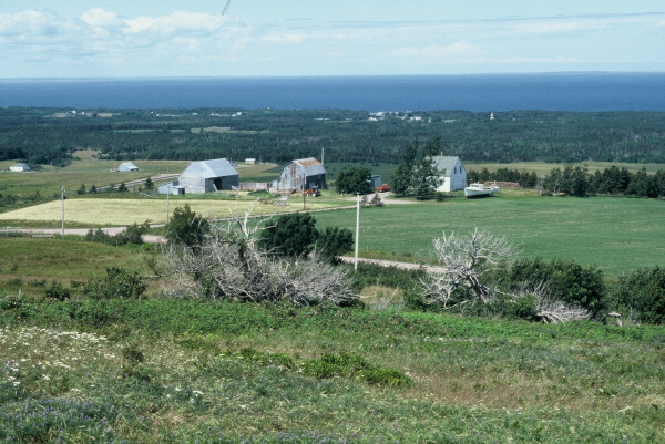
At this stop we will visit a reference section having the longest and most intensively studied record of an Allerød paleosol on mainland Nova Scotia between 10.5 and 11.8 ka ago (~12.5-13.8 CAL). The site is located along the Northumberland Strait shore 10 km southwest of Arisaig near the village of Lismore. The section is located near an outwash delta complex that formed when late northward-flowing ice began to retreat toward the Antigonish Highlands. These outwash fans contain 35% igneous and volcanic clasts from the Antigonish Highlands.
Summary for non-geologists: The Lismore coastal section reveals evidence of rapidly changing climates at the end of the last ice age. Glacial lakes covered the coastal lowlands of the Northumberland Strait, as glaciers receded into the Gulf of St. Lawrence. Sand and clay were deposited in these lakes, the sand deposits closer to the former shorelines. When the ice left, these lakes drained out to the sea (which was much lower at the time) and were eventually replaced by swamps surrounded by sparsely forested tundra. Suddenly and quite dramatically, glaciers re-advanced and dammed up some of the area allowing ice marginal lakes to reform and submerge the swamps. No one is certain why glaciers advanced again during this period of global warming at the end of the last ice age, but the record of this period of rapid climate change is recorded in the cliffs of Lismore.
Description
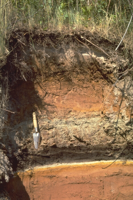
The section consists of Silurian sandstone overlain by 2 m of red, medium to fine gravel to sand and horizontally laminated fine sand and silty clay with a grey clayey paleosol on top. A 30-50 cm thick, continuous peat layer overlies the sand silt unit consisting of black fibrous, organic peat at the base overlain in sharp contact with a grey sandy peat. A laminated fine sand with silty clay layers overlies the peat, which is capped by a modern podzol, 30-40 cm thick. The base of the peat is about 3 m above present sea level. Southwest along the shoreline, cliffs reveal a thicker section of waterlain sediments, with coarse to fine red laminated sand at the base, and coarse gravelly sand on top. The stratigraphic relationship of the sand covering the peat bed and the gravelly sand in the adjacent section to the southwest is uncertain.
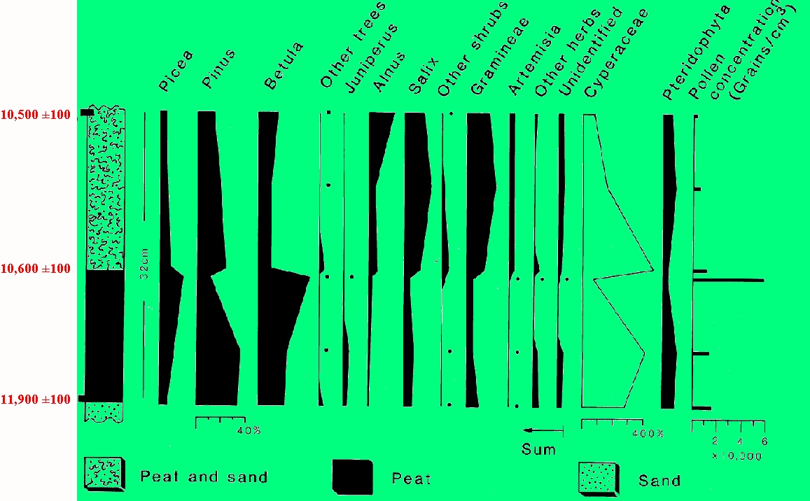
Increments 2 cm thick from the base and top of the peat bed gave radiocarbon ages of 11,900 ± 100 yr B. P. (GSC-4153) and 10,500 ± 120 yr B. P. (GSC-4156), respectively. A sample from the contact of the sandy peat and fibrous peat was dated at 10,600 ± 100 yr B. P. (GSC-1762).
Pollen counts from the peat soil at Lismore show that Cyperaceae (sedge) is the dominant pollen taxon, throughout the sequence, declining from high levels at the base of the compact peat, rising again in the sandy peat but gradually declining toward the top of the organic deposit. Within the lower peat, Betula (probably shrub birch) and Picea show increases upward to a maximum at the contact with the sandy peat. The Pinus (pine) pollen profile is attributable to long-distance transport because its abundance is inversely proportional to pollen concentrations, which rise from low levels at the base to a maximum at the top of the compact peat, and low values above. In the sandy peat, Betula and Picea decline abruptly, and Cyperaceae, Salix, Alnus (alder), Gramineae, and Artemisia increase.
Fossil beetles also give a good indication of the paleo-environments of the Lismore site. Randy Miller (see reference below) studied beetles in the peat and came up with this analysis. The abundance of beetle remains were highest near the bottom of the peat in samples that were most organic. Based on the available radiocarbon chronology, these samples are probably older than 11 ka. Species of staphylinid beetles were most abundant at Lismore. Total numbers of individuals were also higher for this group of beetles. The fossils identified to the species level include Acidota cf. A. quadrata, Olophrum consimile, Olophrum rotundicolle and Tachinus cf. T. tachyporoides. Other staphylinid beetles included Stenus spp., and Eucnecosum sp. The most common ground beetles were Dyschirius spp. and beetles from other families were also present. All these beetles are typical of riparian (swampy) habitats, either living in Carex or Sphagnum bogs, under leaf litter, or on sandy shores of standing or slow moving water. All the species identified above are typical of the boreal forest, open woodland (tundra transition) and their presence suggests conditions cooler than at present. In the sandy peat, beetle fossils are less common and only a very few fragments were recovered from the top of the section. The beetle evidence from this site suggests that boreal conditions existed at the site prior to 11 ka, however there is little indication of any change to suggest a cooling climate associated with the Younger Dryas event.
Interpretation
The southwest section is interpreted to be an older outwash delta deposit with coarse facies representing topset beds and fine sand representing foreset beds. It is not known whether deltas along the Arisaig shore are glaciomarine or freshwater deltas. The lack of Late Wisconsinan submergence features in the region, and the lack of fossils, suggest that they are freshwater in origin, forming in ice-dammed lakes coeval with deposition of the lower fine-grained laminated sediments. After the drainage of the glacial lakes, shallow, wet depressions on the delta surface quickly became sedge meadows and peat began to accumulate about 11.9 ka (~13.9 CAL). Birch shrubs were prominent surrounding the wet areas along with other shrubs, herbs and grasses. By approximately 11 ka (~12.9 CAL) birch shrubs had become more abundant on the landscape and vegetation in general was more prolific. Spruce trees were probably not abundant based on the moderate Picea pollen peak. Pollen analysis at Chance Harbour Lake, about 30 km to the southwest, indicates that spruce trees had migrated there by this time (Jetté and Mott, 1989). An abrupt climatic change then took place beginning with the deposition of sandy peat. Shrub birch was replaced by willows, grasses and other herbs. Reduced Picea pollen levels suggest deforestation of spruce. This change is dated at 10.6 ka (~12.6 CAL). Environmental change occurred before inundation of the site by inorganic sediments after 10.5 ka (~12.5 CAL).
The laminated, fine-grained sediments overlying the peat are interpreted as ponded sediments from a lake or floodplain environment. The lack of associated coarse facies favour a lacustrine or glaciolacustrine origin. A relative sea level rise could create ponded conditions either by direct inundation of the land or by re-grading of rivers. This is unlikely, however, because the sea level record in the region shows a drop in relative sea level of -35 m to - 80 m (Quinlan and Beaumont, 1982) at the time of deposition of the laminated sand (10.5 ka). Lake formation implies ponding by the regeneration of a glacier during the Younger Dryas in the Gulf of St. Lawrence region. The extent of this glacier can be defined by till deposits which bury peat paleosols across northern Nova Scotia, and ice-dammed lakes in the periphery of the glacier. Glacial till-covered sites are found both to the south and east of the Lismore section and ice is also inferred to have been in St. Georges Bay to the west. An ice-free re-entrant in the Gulf of St. Lawrence ice mass may explain the lack of evidence of Younger Dryas glacier cover in the Lismore area, or perhaps more likely the region was initially covered by cold-based ice and the soil preserved before rapid melting of the glacier and subaqueous sand deposition.
Some Useful References
- Jetté, H. and Mott, R. J. 1989:
- Palynostratigraphie du tardi-glaciaire et de l'Holocéne de la région du lac Chance Harbour, Nouvelle-Ecosse; Géographie physique et Quaternaire, v. 43, p. 27-38.
- Miller, R. F. and Elias, S. A. 2000:
- Late-glacial climate in the Maritimes Region, Canada, reconstructed from mutual climatic range analysis of fossil Coleoptera; Boreas, v. 29, p. 79-88.
- Mott, R. J. and Stea R. R., 1994:
- Late-Glacial (Allerød/Younger Dryas) buried organic deposits, Nova Scotia, Canada; Quaternary Science Reviews, v. 12, p. 645-657.
- Quinlan, G. and Beaumont, C. 1982;
- The deglaciation of Atlantic Canada as reconstructed from the postglacial relative sea-level record; Canadian Journal of Earth Sciences, v. 19, no. 12, p. 2232-2246.
Go back to the chopper (virtual field trip home page) or