
Stop 20: Glacial Lake Dawson (Phases 1 and 2) in Southwest Cape Breton

As the chopper hovers over the Gulf of St. Lawrence, we can see Long Point, and the Creignish Hills of Cape Breton Island. At the end of the last glaciation the ocean was replaced by a large glacier that filled St. Georges Bay and butted up against the Creignish Hills. Doug Grant proposed that a glacial lake, which he termed Glacial Lake Dawson, was dammed up between the glacier in the bay and the hills. There were two separate phases of Glacial Lake Dawson: the ice retreat lake (Phase 1), formed during a period of climatic warming from 13-11 ka (~15.6-12.9 CAL), and the ice advance glacial lake (Phase 2) that re-formed during the Younger Dryas cooling (11-19 ka ~12.9- 11.5 CAL). Look at the map for locations of the stratigraphic sections mentioned at this stop.
Summary for non-geologists: Instead of the ocean, the western coast of Cape Breton Island was covered with glacial lakes at least two times at the end of the last glaciation about 15,000 years ago. These lakes were dammed between a glacier in the Gulf of St. Lawrence and the Creignish Hills. Sand and clay deposits deposited in these glacial lakes are found in low-lying areas all along the coastal region.
The Campbell Site
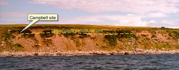
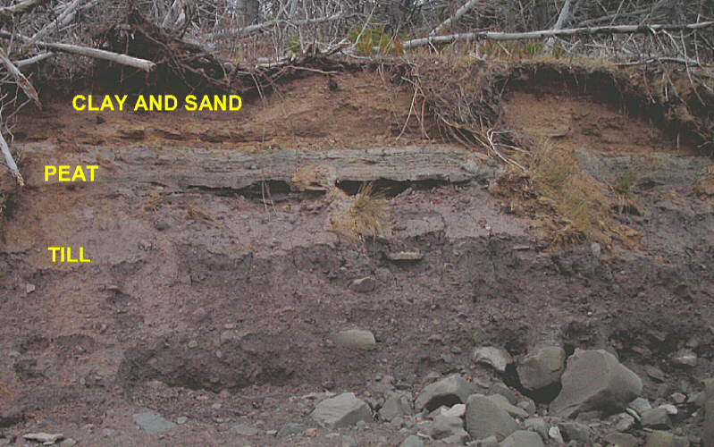
The Campbell site was discovered by D. R. Grant in 1970. The site reveals sand and till overlain by a peat layer, then a massive sand unit. View the detailed stratigraphic section of the site indicated on the photo above. The buried organic layer represents a warm-climate phase at the end of the last ice age that was abruptly ended by a rapid and extreme cooling known as the Younger Dryas event. The upper sand was interpreted as a fluvial deposit due to deforestation of adjacent slopes during the Younger Dryas climatic deterioration (Grant, 1994). The facies architecture of these deposits has led us to reinterpret these as glacial lake deposits. The upper unit is draped over the present topography to elevations of 60-70 m, and consists of interfingering silty clay and parallel laminated, normally graded sand facies.
The Centennial Road sections
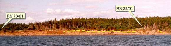
The upper massive sand and clay unit can be traced for 10 km along the coastline. At site RS 28/01 (the Centennial Road section) a peat layer separates a lower sand unit from the upper draped sand and clay unit.
View the numbered stratigraphic sections RS 28/01 and RS 73/01 on the photo. The upper unit at section 73/01 can be traced along the entire section and overlies the peat layer at Section 28/01 and the Campbell site. At section 73/01, rhythmites and a coarse bouldery unit, are stratigraphically below the peat layer.
The Judique sections
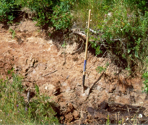
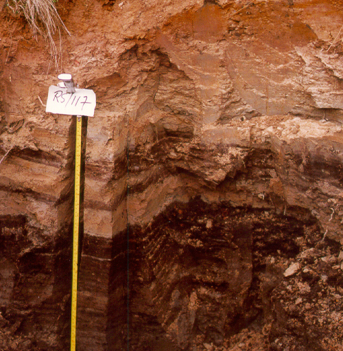
Waterlain, fine-grained sediments overlying the peat paleosol marker horizon can be traced inland near Judique South to elevations of between 60 and 70 m. The photograph to the left is the easternmost buried peat locality found during mapping in the summer of 2000, designated as site RS 117/00. See the map to see the location of this buried organic bed. The maximum thickness of waterlain, fine-grained sediment above the soil horizon is 1.5 m. Wood (Salix) from the organic horizon was radiocarbon dated at 11,200 ± 120 yr B. P. (GSC-6518). View the detailed stratigraphy at the site. This section is nearly identical to one described in the town of Judique by Stea and Mott (1998), where as much as 3.4 m of massive clay was found overlying the thin peat layer. See the Judique section.
Interpretation
Sediments overlying the organic paleosol marker horizon are fine-grained and draped over topography, indicating subaqueous marine or lacustrine sedimentation. Marine deposition can be ruled out based on the known RSL history of the region. After 12 ka (~14 CAL) sea level had dropped to between 50 and 100 m below present in the Gulf of St. Lawrence (Josenhans and Lehman, 1999). The organic paleosol beneath the clay sediments would imply a precipitous drop and rise in relative sea level not documented elsewhere in the Gulf. An examination of similar clay deposits in central Nova Scotia has found no micropaleontology evidence for marine influence. Open work gravel and rhythmites in the lower waterlain sediments (see RS 73/01) are characteristic of proximal subaqueous fan deposits and distal glacial lake bottom sediments (Ashley, 1995).
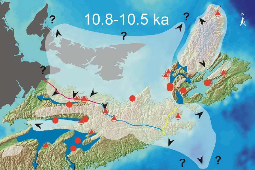
In order to dam bodies of water to levels of 60-70 m against the Creignish Hills, a glacier must have existed in the Gulf of St. Lawrence, as postulated by D. R. Grant in 1994. Horizontal lamination and graded beds in the sand facies of the upper subaqueous unit, suggests deposition from suspension in a distal glacier setting, but the associated massive clay facies are puzzling. Rhythmic bedding of silt/sand and clay is inherent to glacial lakes in a distal or proximal setting, except in shallow water (Ashley, 1995). The extent and elevations of these deposits, however, suggests water depths exceeding 50 m. Ice buildup in the lowland shelf areas, and suppressed melting may explain this phenomenon. Look at a map that shows the proposed extent of ice advance during the Younger Dryas glaciation and the position of glacier lakes. We have identified two phases of glacial lake development, before and during the Younger Dryas. A more complete description of the Glacial Lake Dawson hypothesis and the Younger Dryas shelf glacierization hypothesis is available in Stea and Mott (1998) (see references below) and also look at the Lantz site in central Nova Scotia.
In summary, the sequence of events can be listed as follows:
- Ice retreat ca. 12 ka (~14 CAL) and development of Glacial Lake Dawson (1).
- Drainage of Glacial Lake Dawson (1) and ice retreat to a small ice cap localized in the emergent Gulf of St. Lawrence. Biota migration across the deglaciated landscape- ca 11.5-10.8 ka (~13.4-13.0 CAL).
- Climate cooling and increasing storm intensity. Advance of a remnant ice cap in the Gulf of St. Lawrence. Formation of Glacial Lake Dawson (2) ca. 10.8-10.9 ka (~13-11.5 CAL).
- Drainage of Glacial Lake Dawson (2). Climate amelioration after 10 ka.
Some Useful References
- Ashley, G. M. 1995:
- Glaciolacustrine environments; Chapter 13 In: Menzies, J. (ed.) Modern Glacial Environments: Processes, Dynamics and Sediments. p. 417-247.
- Grant, D. R. 1994:
- Quaternary Geology, Cape Breton Island, Nova Scotia; Geological Survey of Canada, Bulletin 482, 159 p.
- Josenhans, H. and Lehman, S. 1999:
- Late glacial stratigraphy and history of the Gulf of St. Lawrence, Canada; Canadian Journal of Earth Sciences, v. 36, p.1327-1345.
- Stea R. R. and Mott, R. J. 1998:
- Deglaciation of Nova Scotia: Stratigraphy and chronology of lake sediment cores and buried organic sections; Géographie physique et Quaternaire, v. 41, p. 279-290.
Go back to the chopper (virtual field trip home page) or