
Stop 13: Cape George Sections: Interglacial Sea-level <10 m and Early Wisconsinan Ice Advance Across the Gulf of St. Lawrence
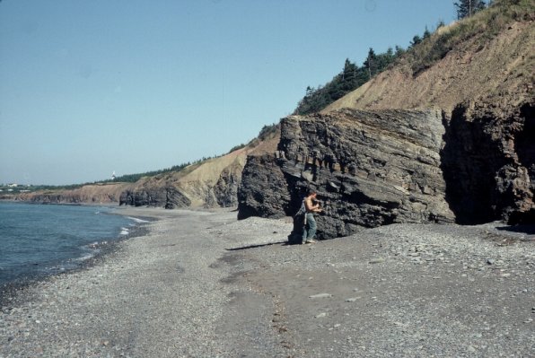
We are making several short stops along the Northumberland Strait coast and Cape George to view stratigraphic sections spanning the last interglacial interval and the last glaciation. At the base of the sections is a raised wave-cut erosional platform, as seen out the chopper window to the left. This is the "rock" on which the eastern Canadian glacial stratigraphy is based, believed to represent a 4-6 m high sea level stand during the altithermal period of the last interglacial, the Sangamon Interglaciation.
J. W. Goldthwait (1924) first described the bench, noting similarities between the modern littoral platform and the emerged platform but doubted that it was marine in origin. He stated that discontinuities in the feature and lack of horizontality suggested an alternative mode of origin, possibly faulting that was late- or post-glacial in age rather than pre-glacial.
Summary for non-geologists: The Cape George sections record a higher sea level during a relatively warm period, called an interglacial, which preceded the last glacial age. Sea levels were at least 4-6 m higher than present because the former high seas cut a flat terrace into rocks at that elevation. Beach sands were also deposited on top of the rock platform. Overlying the beach sands are deposits of angular rock debris and sand, caused by landslides and rock-falls when the region's climate cooled to near tundra conditions after the interglacial. These slope deposits are overlain by glacial deposits called till, when large glaciers advanced along the coast, picking up mud and shells and carrying these inland. Shells of oysters, not presently found in the Gulf of St. Lawrence, can be picked out of the glacial deposits.
Description
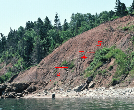
Common to most of the Cape George sections is a sequence of stratified, well-sorted sand and gravel (Unit 2) resting on an emerged abrasion platform believed to be a remnant of a Sangamon high sea level stand (Grant, 1980). The height of this rock bench varies from 4-6 m above MSL. At Cape George Point, this bench is developed on mafic rocks. The surface of the bench, exhumed from under sand and till, is scalloped and smoothed. The sand deposits exhibit some faint ripple lamination, normally graded beds, and heavy mineral segregations and the gravel units are characterized by openwork facies and well-rounded, imbricated platy clasts. Unit 2 attains an elevation of 25 m at Livingstone Cove.
Lying above the stratified sand in most of the sections is a distinctive, bouldery to gravelly diamicton (Unit 3) with clasts that are invariably angular and locally derived. The deposit is crudely stratified with subhorizontal sand lenses. This sediment varies in thickness from 4-20 m.
Stratigraphically above this sandy diamicton are two siltier diamicton units distinguished primarily by their stone and shell content. The lower unit (Unit 4) is a relatively stone-free greyish-red diamicton with a silty matrix and robust fragments of Mercenaria sp. found commonly near the base of this unit. Thick exposures rest on bedrock surfaces with striations trending 90°-130°. Large elongate boulders at the base of some sections with stoss and lee form have long axes and surface striations oriented parallel to the bedrock striations. The uppermost unit (Unit 5) is distinguished from the lower shelly till by its abundance of stones and boulders. At some sections it is slightly sandier than the lower till. Till-embedded boulders with striations parallel to their long axes generally trend northeastward. Striations on rock surfaces underneath this till unit along the coast trend from 335° to 045°.
A radiocarbon age of >37 ka was obtained on one of the shell fragments in Unit 4 (GSC-4048, D. R. Grant, personal communication, 1984). Amino acid measurements on shell fragments, calibrated with the kinetic model curve of Wehmiller et al. (1988), indicate a Sangamon (Oxygen Isotope Stage 5) age. Twelve shell fragments of Mercenaria sp. from Unit 4 at Cape George were dated using the electron spin resonance method (Stea et al., 1992). The dates range from 99-188 ka with a mean value of 136 ka. These dates were calculated assuming direct or early uranium accumulation. The older dates are generally from samples with thinner shells and may reflect a complicated U-uptake history. Both methods imply a Sangamon age for the shells, most probably Stage 5e. More recently an OSL (optically stimulated luminescence) age of 115 ± 19 ka was obtained from Unit 2 sand deposits at Cape George (Stea et al., 2002).
Interpretation
The rock bench with potholes on its surface is a marine erosional platform indicating a former sea level of at least 4-6 m above present mean sea level. The well sorted and rounded sand and gravel unit (2)of last interglacial age (115 ka) is likely to be marine in origin, although no fossils have been obtained as yet from the unit. Unit 2 approaches 20 m in elevation, so the erosional platform may not represent the ultimate sea level during the last interglaciation. Unit 3, the stratified diamicton, is interpreted as a product of mass wasting from adjacent rock slopes during the periglacial conditions that preceded the onset of glaciation. Units 4 and 5, the tills overlying the marine and colluvial deposits, were emplaced by ice sheets moving to the east and southeast across the Gulf of St. Lawrence (hence the shelly tills), and then northeastward from the Scotian Ice Divide.
Some useful references
- Goldthwait, J. W. 1924:
- Physiography of Nova Scotia; Geological Survey of Canada, Memoir 140, 179 p.
- Grant, D. R. 1980:
- Quaternary sea-level change in Atlantic Canada as an indication of crustal delevelling; in Earth Rheology, Isostasy and Eustasy, ed. N. A. Mörner; John Wiley and Sons, London, p. 201-214.
- Stea, R. R., Mott, R. J., Belknap, D. F. and Radtke, U. 1992:
- The pre-Late Wisconsinan chronology of Nova Scotia, Canada; in P. U. Clark and P. D. Lea, eds., The Last Interglaciation/Glaciation Transition in North America; Geological Society of America, Special Paper 270, p. 185-206.
- Stea, R. R., Scott, D. B., Godfrey-Smith, D. and Mott, R. J., 2002:
- Sangamon interglacial sea-levels of +20 m in Maritime Canada; in Abstracts Volume 27, Geological Society of Canada-Mineralogical Society of Canada, Joint Annual Meeting, Saskatoon, p. 113.
- Wehmiller, J. F., Belknap, D. F., Boutin, B. S., Mirecki, J. E., Rahaim, S. D. and York, L. L. 1988:
- A review of the aminostratigraphy of Quaternary mollusks from United States Atlantic Coastal Plain sites; in Easterbrook, D. J., ed., Dating Quaternary Sediments; Geological Society of America Special Paper 227, p. 69-110.
Go back to the chopper (virtual field trip home page) or