
Reading Room 1: The Story of Glaciers in Maritime Canada
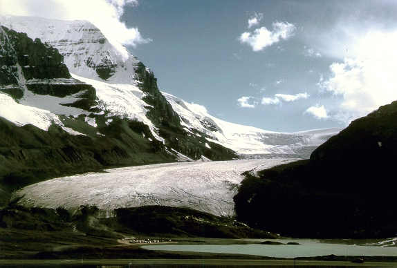
This reading room provides a brief overview of the history of glaciation in Maritime Canada with emphasis on Nova Scotia. If you are a rookie glacial geologist I recommend visiting some of the many websites on basic glacial geology. Since there are no glaciers left in Nova Scotia, I borrowed one from Alberta, the Athabasca glacier!
The last two million years of Earth history, known as the Quaternary Period have been a wee bit chilly. The land masses of the northern Hemisphere have been periodically covered by large ice sheets. All of the Maritime Provinces were covered by kilometre-thick glaciers as recently as 20,000 years ago (or 20 ka for short).
Just after the glacial theory was born, a controversy emerged about the nature of glaciation in Maritime Canada which still resonates today. Was the ice local, originating in upland areas and confined to the land masses, or was the ice part of a great continental ice sheet from Quebec which crossed the Bay of Fundy? The Reverend D. Honeyman, curator of the provincial museum in the late 1800s, discovered basalt boulders near Halifax that had been carried all the way from the North Mountain, a distance of 130 km (80 miles). He used the observation to support the concept of a Quebec-based ice movement that crossed the Bay of Fundy. Robert Chalmers (1895) of the Geological Survey of Canada mapped surficial deposits and glacial features in Eastern Canada. He carefully mapped glacial grooves and striations in Nova Scotia and proposed that northern Nova Scotia had been glaciated largely by local glaciers with floating ice a secondary agent in low-lying areas. Chalmers (1895, p. 95) stated his position: "the depression of the Bay of Fundy was not crossed by land ice from southern New Brunswick … Neither has Nova Scotia been glaciated by extra-peninsular ice from the north or northeast."
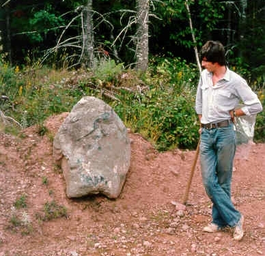
A basaltic erratic in till in southern Nova Scotia.
L. W. Bailey (1891) and W. H. Prest (1896), working in mainland Nova Scotia, observed erratics from both local and New Brunswick sources that supported both previous views. Bailey stated the compromise position (1898, p. 26): "As in other parts of southwestern Nova Scotia the facts connected with the glaciation of Digby Neck are, in the opinion of the writer, best explained upon the supposition of submergence beneath a continental glacier moving southward and bringing debris even from the other side of the Bay of Fundy, followed by a period of more local and restricted distribution, when the higher portions of the peninsula became themselves the centre of the movement, the latter now occurring in all directions."
In the early and middle part of the Twentieth Century many geologists, most notably J. W. Goldthwait (1924, abandoned the idea of local Maritime glaciers in favour of an all encompassing Laurentide (Quebec-based)glacier. The glacier "come from away" view held sway until a renewed geological mapping effort during the 1950s in Nova Scotia by Harcourt Cameron and Rupert MacNeill at Acadia University in Wolfville, Nova Scotia, who found evidence for local glaciers in Nova Scotia. Charles Hickox (1962) later confirmed that granite erratics on the North Mountain had been transported northward from a local ice cap over the South Mountain Batholith in Nova Scotia and not southward from New Brunswick as Goldthwait (1924) had suggested. Regional analyses of glacial features from air photographs by Vic Prest and Doug Grant in 1969 led them to postulate that several large local glaciers termed the Appalachian Glacier Complex, developed in the region. They proposed that this local ice buildup was not due to climatic changes, but to re-directed ice flow into the Bay of Fundy and Gulf of St. Lawrence, as sea-level rose at the end of the last glaciation.
In the late 1950s the radiocarbon dating method was invented by Willard Libby. The timing of glaciations could now be established by determining the age of trees, and other organic materials buried by glaciers during the last glaciation. In Nova Scotia the last interglacial period was found to be older than the 30-50 ka limit of the radiocarbon dating method. In the last several decades there has been an explosion in glacier mapping studies prompted in large part by the search for mineral deposits. These have led to further refinements in the local ice model which I will summarize in a series of cartoons and descriptions.
The chronology used throughout the virtual tour on events younger than 49 ka (40,000 radiocarbon years before present) is based on the decay rates of a radioactive isotope of Carbon(14C). Radiocarbon "years" however, can deviate significantly from the actual calendar age. This deviation was discovered by comparing the elapsed time as indicated by yearly tree ring counts with radiocarbon ages of the tree-ring intervals. There is a further complication as one radiocarbon age can represent a range of calendar years due to the irregular production of Carbon 14 in the atmosphere. In the virtual tour "radiocarbon years" are used first since they are derived from date measurements. The approximate median value of corrected "calibrated" age ranges (~CAL) will be presented afterwards. Visitors to the virtual tour can calibrate the published radiocarbon dates using the Calib 4.3 program from the University of Washington.
We can envision the glacial history of Maritime Canada as repeated battles for territory between land-based glaciers and the sea. During periods of climatic cooling ice sheets develop and advance, aided by the reflection of the sun's light from the white snow surface. Sea levels drop as ocean water is used to make ice. The glaciers grow, coalesce and flow all the way out to the edge of the continental shelf. There, melting and ice sheet disintegration begin as glaciers become buoyant in deep water. This starts the retreat process, which is accentuated as the sea-level rises, and helps to further destabilize the ice sheets. Finally the rising sea and global warming win out and the glaciers are in full retreat. The land areas, depressed by the weight of the kilometre-thick glaciers, are driven upwards as the earth rebounds. The processes of glacial growth and decay have been repeated many times during the past million years driven by planetary climatic cycles of warming and cooling.
When did glaciers first develop in eastern Canada? We don't know! The oldest glacial deposits in Nova Scotia are called the Bridgewater and Mabou conglomerates, deposits of deeply weathered and iron-cemented drift and outwash thought to be as old as Tertiary to early Pleistocene. Mollusc shells, dated between 200-309 ka, have been found in glacial deposits in southwest Nova Scotia
Prior to the last glaciation the climate was warmer than today, perhaps as balmy as northern Georgia! This period, called the Sangamonian Interglaciation, lasted from 128 to 75 ka. Buried under glacial deposits throughout Nova Scotia are the flattened remains of trees from the great interglacial forests. Pollen from buried forests and bogs shows that the climate fluctuated considerably during this interglacial period, with an early climatic optimum followed by less temperate times that culminated in glaciation. At the end of the interglaciation the climate cooled, the forests changed to tundra, and mastodons roamed Nova Scotia. The remains of an adult and juvenile mastodon have been unearthed at the gypsum quarry at East Milford. (Go to Stop 3)
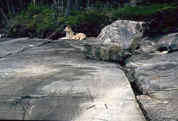
Glaciers in Nova Scotia can be reconstructed by the legacy they left behind. The changing flow paths of Maritime glaciers are revealed on rock outcrops by elongate scratches called striae. On this outcrop near Tangier, Nova Scotia, three directions of striae are indicated. The earliest ice flow is towards the east, (pencil) followed by a flow to the southeast, and finally due south.
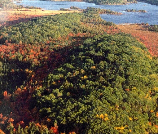
The direction of ice flow can also be determined by larger landforms, known as drumlins. These streamlined hills are formed underneath the ice sheets, moulded by a glacier as it flows around an obstacle. These are fine examples of drumlins from southern Nova Scotia with the stoss or blunt end facing us. The tapered end points towards the southeast, away from the observer in the direction of glacier flow.
Models of the Appalachian Glacier Complex
In the last 75 ka glaciers centred in Maritime Canada advanced and retreated at least four times. Glacier formed and grew locally because of a combination of increased snowfall, much colder temperatures and isolation from continental glaciers by deep ocean channels and the Appalachian mountain ranges which surround the region. The next series of cartoons will depict why, how, where, and when these glaciers developed and how far they extended.
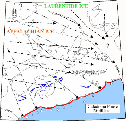
The oldest observed ice flow patterns on land in Maritime Canada are eastward and southeastward. These flows were originally attributed by Chalmers (1895) to the Appalachian Mountain-based "Northumberland Glacier". Striae relating to this flow are inscribed on a raised interglacial marine bedrock terrace along the Northumberland Strait from New Brunswick to Cape Breton Island and overlain by several till sheets. Glaciers first developed in the high Appalachian Mountains of northern Vermont and New Hampshire, but later a large dome developed in northern New Brunswick called the Gaspereau Ice Centre, which produced southeastward striation patterns across southern New Brunswick and Nova Scotia.
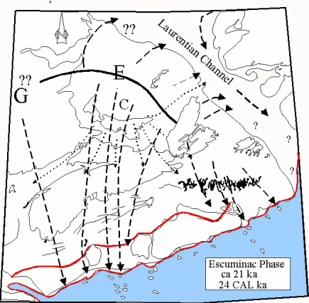
Southward and southwestward ice flows that post-date the Caledonia Phase are recorded by striae and erratics in Nova Scotia and Prince Edward Island. These flow trajectories are thought to be the result of an ice centre or divide in the in the Gulf of St. Lawrence termed the Escuminac Ice Centre (E). This divide may have formed as a result of Mid-Wisconsinan ice retreat out of the Laurentian Channel isolating a Gulf glacier from the Laurentide Ice Sheet to the north. The Escuminac Ice Centre may have extended into New Brunswick to account for a correlative southward flow in southwest Nova Scotia or may have co-existed with a separate dome over the highlands of New Brunswick called the Gaspereau Ice Centre (G). Ice outflow from the Escuminac Ice Centre during the Escuminac Phase may have been in the form of rapidly flowing ice streams. These streams converged into inter-bank channels on the outer shelf, drawn by calving and the production of icebergs in the deeper water of the continental shelf edge. Later, the divide became isolated on the shelf north of Nova Scotia (Chignecto Glacier C) and ice flow was drawn southwestward into the Bay of Fundy.
Another possibility for regional southward ice flow may be a larger glacier crossing the Laurentian Channel from the eastern Quebec-Labrador Highlands, perhaps deflected by the Gaspè Highlands. J. W. Goldthwait called this glacier the "Acadian Bay Lobe". This hypothesis seems less likely as Laurentide erratics have not been reported in Nova Scotia or P. E. I. with the exception of one anorthosite boulder by Vic Prest and Eric Nielsen in 1987.
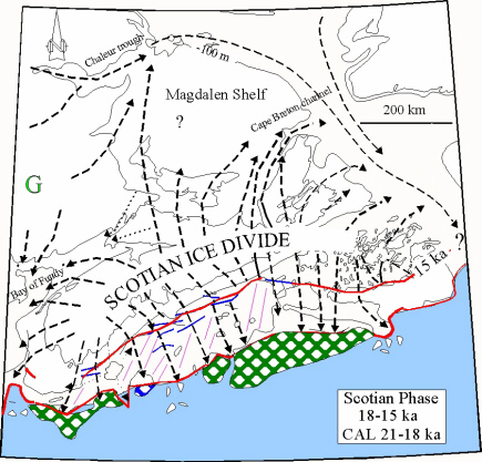
An ice divide (Scotian Ice Divide) formed over Nova Scotia as the larger Escuminac Ice Divide was deflated by rapid ice flow into the marine channels bordering Nova Scotia, triggered by global warming and sea level rise. Nova Scotia ice was eventually cut off from the Escuminac and Gaspereau ice sources by development of ice streams in the Bay of Fundy, and the Chaleur and Cape Breton channels. The Scotian Ice Divide may have extended as far as Sable Island Bank and the series of banks which line the outer shelf. The Scotian Phase glacier later settled at the Scotian End Moraine Complex, the site of former ice retreat margins from earlier glacial advances. The Scotian Shelf End Moraine Complex (shown as the blue lines near the Nova Scotia coastline on the figure to the right) formed sometime between approximately 15.5 ka (~18.5 CAL) to 17 ka (~20 CAL). Calving retreat of the Scotian Ice Divide was accelerated by sea level rise. By 14 ka (~16.8 CAL) the ice margin was close to the present day coastline over much of Nova Scotia but the glaciers persisted over the present land areas for at least another 1500 years. This was not the case in the Gulf of Maine and Bay of Fundy, where vigourous ice stream drawdown cleared ice from these regions leaving a glacio-isostatically depressed landscape. Before the land rebounded, beaches, and deltas formed that have been radiocarbon dated between 15 (~17.9 CAL) and 12.6 ka (~15 CAL).
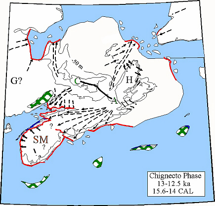
Cross-striated bedrock exposures along the coast of the Bay of Fundy record distinct shifts of ice flow from northeastward during the Scotian Phase, to northwestward and finally westward during the Chignecto Phase. Small ice caps were generated after Scotian Phase retreat perhaps during a brief late-glacial climatic reversal over southern Nova Scotia, (SM-South Mountain Ice Cap), the Northumberland Strait area (C-Chignecto Glacier) and the Antigonish Highlands in northern Nova Scotia (A-Antigonish-Chedabucto Bay Glacier Complex). Even today, these are areas of high snowfall accumulation. Field evidence of a short late-glacial re-advance is given by Hickox (1962) who described kames on top of a marine delta related to Scotian Phase deglaciation along the Bay of Fundy. On the Atlantic coast of Nova Scotia, ice flow during the Chignecto Phase was southwestward. Moraines in the inner Scotian Shelf are oriented NW-SE, perpendicular to the Chignecto Phase flow pattern, and may represent the margin of Chignecto Phase ice in the offshore areas. This event is bracketed between 13.2 (~15.9 CAL) and 12.3 ka (~14.5 CAL) based on radiocarbon dates from lakes cores in front of and behind glacier margins.
After the Chignecto Phase the climate warmed and glaciers melted and disappeared from most of Nova Scotia. Forests with spruce and pine started to invade southern Nova Scotia, along with a host of critters. The first human inhabitants of Nova Scotia came about 11 ka, (~12.9 CAL) perhaps hunting migrating Caribou. Sea-level began to rise from a low point of 80-100 m below present at the outer banks.

Around 10.8 ka (~12.9 CAL) this warming trend was abruptly terminated. In southern Nova Scotia winter snow and ice fields may have persisted throughout the summers. Remnant glaciers were re-invigorated in northern Nova Scotia and glacial lakes formed in areas where these glaciers readvanced and dammed up old drainage pathways. In lakes adjacent to the glaciers, meltwater from the snow packs carried mud into the lake basins, producing a distinctive sediment layer, a climate signature in the record of lakes throughout Maritime Canada. Glacial deposits including till and glacial lake mud were deposited over older peat bogs from a preceding warm period. After this climate fluctuation, the climate warmed rapidly, and after 10 ka (~11.5 CAL) spruce forests were established over much of Nova Scotia.
Go back to the chopper (virtual field trip home page) or