
Stop 18: Sugar Camp Quarry Sections: The End of the Last Interglacial and Onset of Wisconsinan Glaciation
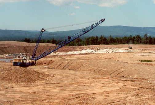
The Sugar Camp quarry is operated by Georgia Pacific Ltd., and located in southwestern Cape Breton. It reveals a complex section of Quaternary deposits overlying Carboniferous gypsum bedrock. A 500 m long north-south section was excavated by the dragline seen in the photo to the left. The Creignish Hills can be seen in the background. The stratigraphy seen in the stripping wall can be considered typical of the River Inhabitants Lowlands and is similar to the River Inhabitants Section.
Summary for non-geologists: The Sugar Camp Quarry is a huge excavation showing many layers of glacial deposits overlying gypsum bedrock. The oldest glacial deposit deep in the quarry is a sand layer probably formed by glacial meltwater streams. Overlying this is a hard grey glacial till (mixture of boulders and clay deposited directly by a glacier), then wood and peat layers which record the last interglacial period, a time of warm climates between 125,000 and 75,000 years ago. Above the organic layers a gradual cooling is recorded, starting with glacial lake sediments called varved clays (regular layers of silt, sand and clay deposited in a glacial lake during summer melting and winter freezing periods). Above these clay deposits are two layers of till from separate glaciers that built up in the Maritime Provinces.
Description
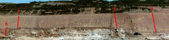
Click on the red sections for the detailed stratigraphic logs.
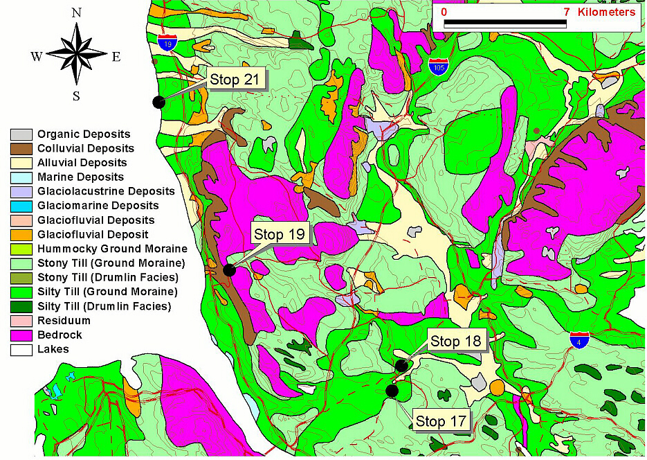
 Click on the rock for a detailed map of the quarry area.
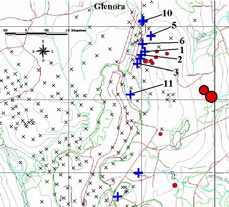
View the numbered stratigraphic sections shown on the map:
 />
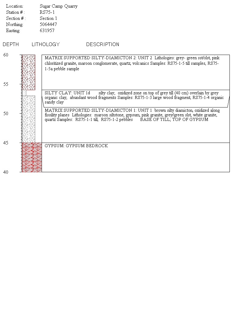
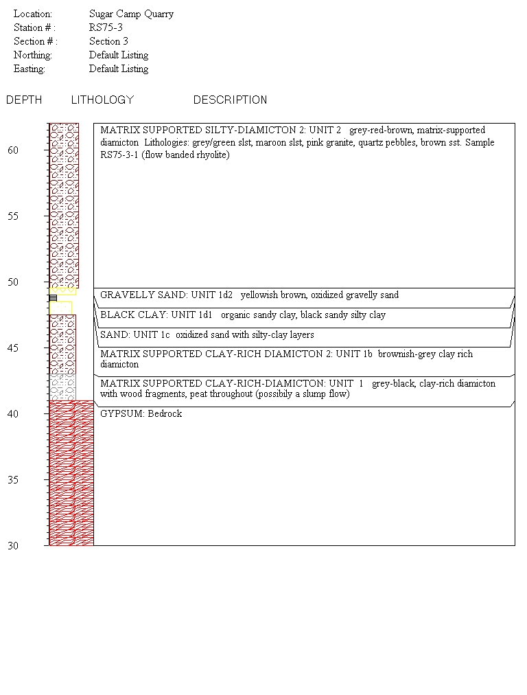
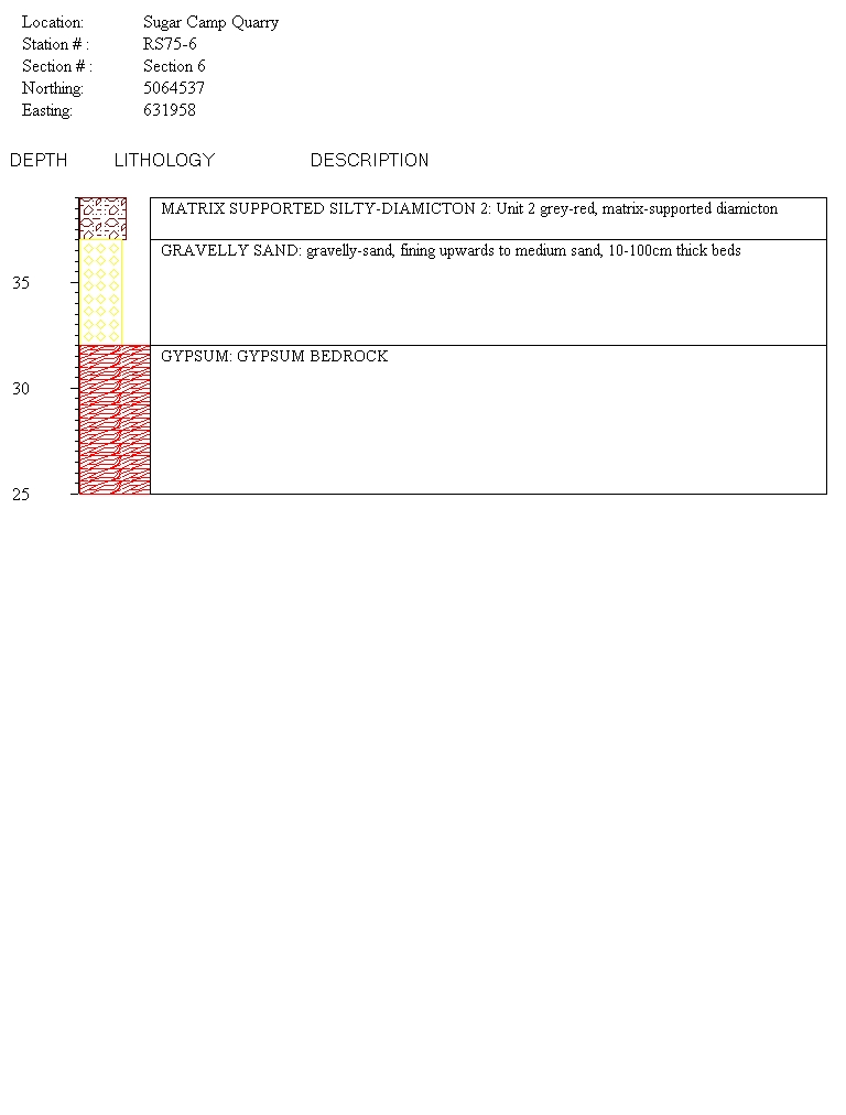
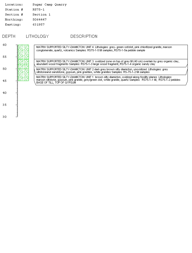
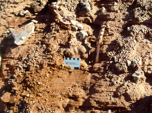
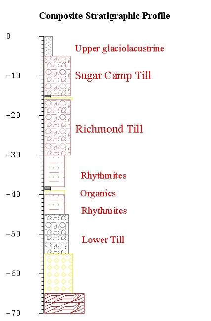
/>The Sugar Camp gypsum quarry is the type section for the Quaternary stratigraphic units of the lowland regions of southwest Cape Breton. The basal unit in the Sugar Camp quarry is a grey-brown, to dark grey, matrix-supported silty diamicton (till). Locally, as at Section 11, layers of woody debris occur, including large pieces of wood. Layering of boulders and slump-deformation were noted in the unit. The lower grey diamicton (Unit 1a) changes upward into a brownish silty clay diamicton (Unit 1b) with few clasts, as seen at Section 2.
Section 10 at the north end of the quarry reveals a laminated silty clay and sand, with calcareous concretions, overlying the brown diamicton.
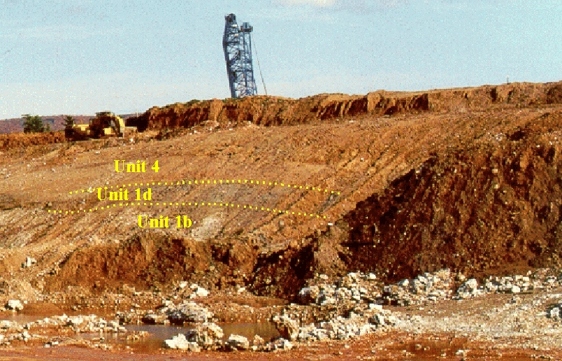
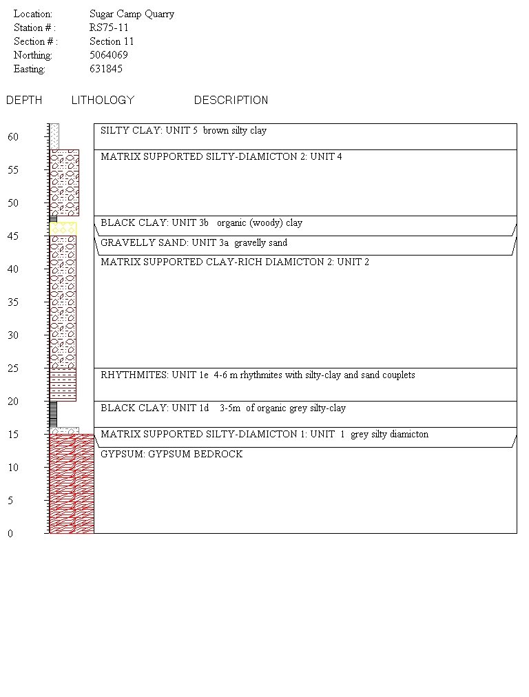
Section 1 shows an Fe-oxidized zone with sand and silt layers (1c) on top of the diamicton units (1a and b), capped by a thin layer of organic, woody debris (Unit 1d). At section 11, the basal diamicton unit (1) is overlain by 3-5 m of organic grey silty-clay (Unit 1d), followed by a 4-6 m thick package of rhythmites (Unit 1e) with regularly spaced silty clay and sand couplets.
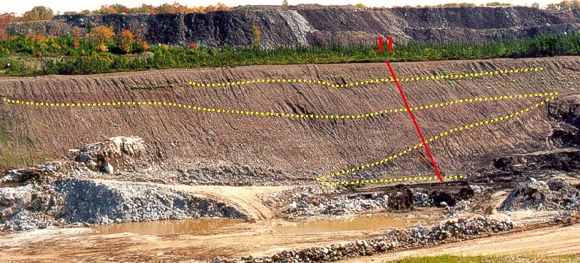
Overlying the rhythmites and the oxidized sand and gravel, with a clearly erosional contact, is a massive grey-red, silty diamicton (Unit 2). Large- and small-scale till-wedges, or clastic dykes, intrude Unit 1. The stripping wall section shows a large till wedge of Unit 2 intruding the lower organic-bearing diamicton (Unit 1). The apparent dip of the wedge is about 30 degrees to the north. This massive, silty till has been termed the Richmond Till by Grant (1984), as it forms the core of many of the large drumlins in Richmond County.
Above or within Unit 2 at Section 11 is a thin gravelly sand layer (2 m) (Unit 3a) and 1 m of organic (woody) clay (Unit 3b). Whether this organic zone represents a separate period of ice retreat or a "raft" of the lower organic sediment is an unresolved question. The former hypothesis is more likely to be correct, as the lower organic layers near Section 3 appear to be rafted up into the upper till units (see photo above).
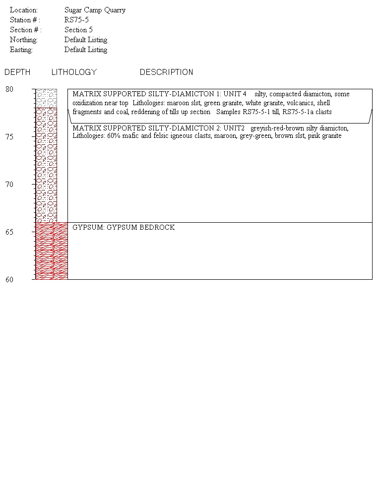
Another till unit (Unit 4) overlies this organic zone, similar in texture and colour to Unit 2, but with a noticeable upsection increase in robust marine shell fragments ( Mercenaria sp.) and coal clasts.
Section 5 is the thickest section of Unit 4. The provenance of the diamicton units is discussed in more detail below. The contact between the two diamicton units (2 and 4) is not easily discerned and is likely to be a gradational one. This till unit shall henceforth be designated as the Sugar Camp Till.
The uppermost stratigraphic unit is a brown, silty clay glaciolacustrine unit (Unit 5), which is a widespread surficial deposit throughout the River Inhabitants Lowlands.
Interpretation
The Sugar Camp quarry section should be regarded as the type Quaternary section for southwest Cape Breton Island because it records a complete depositional sequence from the penultimate glaciation (Illinoian) through the last interglacial and the last glaciation (Wisconsinan). This is assuming that the wood and organics near the base of the section are interglacial in age, equivalent to the buried organics at the East Milford Quarry. A composite section defined from all observations at the quarry, shows a conformable sequence of till, ice-retreat glaciolacustrine deposits grading into interglacial organics, and followed by ice-advance glaciolacustrine deposits, then till. The overlying till (Unit 2, designated as the Richmond Till (Grant and King, 1984), has a pebble assemblage dominated by grey, green and maroon siltstone, conglomerate, pink and white granite, diorite and gabbro, and minor felsic volcanics. The most likely source area is the Creignish Hills to the west, which hosts NeoProterozoic granite, diorite and the Fisset Brook Formation (brown) with some volcanic rocks. This till represents the initial Early Wisconsinan east-southeastward ice flow termed the Caledonia Phase. The overlying till (Sugar Camp Till) is characterized by the introduction of coal fragments and robust Mercenaria shell fragments. The source of the coal is likely to be upper Port Hood Formation, which outcrops around the southern and eastern side of Inhabitants Bay. McClenaghan and DiLabio (1992) also defined this late northward flow in southeast Cape Breton based on till pebble lithology and striation data. Shell fragments can be used to correlate with shelly till sheets in the Isle Madame area described by Grant (1994). He hypothesized that northward flow stemmed from an isolated ice dome on the Scotian Shelf. Stea et al. (1998) account for northward flow with a much larger, linear ice divide over Nova Scotia and the Continental Shelf off Cape Breton Island. Stea et al. (1998) assigned the northward flow event a Late Wisconsinan age based on correlation with the radiocarbon-dated Scotian Shelf End Moraine Complex offshore.
Some Useful References
- Grant, D. R. and King, L. H., 1984:
- A stratigraphic framework for the Quaternary history of the Atlantic Provinces; in Quaternary Stratigraphy of Canada - A Canadian Contribution to IGCP Project 24, ed. R. J. Fulton; Geological Survey of Canada, Paper 84-10, p. 173-191.
- Grant, D. R. 1994:
- Quaternary Geology, Cape Breton Island; Geological Survey of Canada, Bulletin 482, 159 p.
- McClenaghan, M. B. and DiLabio, R. N. W. 1996:
- Ice flow history and glacial dispersal patterns, southeastern Cape Breton Island, Nova Scotia: implications for mineral exploration; Canadian Journal of Earth Sciences, v. 33, p. 351-362.
- Stea, R. R., Piper, D. J. W., Fader, G. B. J. and Boyd, R. 1998:
- Wisconsinan glacial and sea-level history of Maritime Canada, a correlation of land and sea events; Geological Society of America Bulletin, v. 110, no. 7, p. 821-845.
Go back to the chopper (virtual field trip home page) or