
Stop 21: Long Point Section: Sea-level <10 m During the Last Interglacial
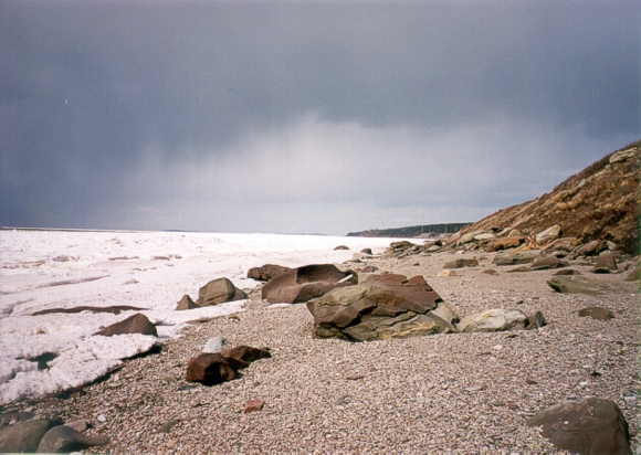
Do the ominous clouds in the background portend a return of the glaciers? We have landed the chopper along the shore of St. Georges Bay where the ocean has eroded the cliffs and opened another chapter in the geological history book of Nova Scotia. An intense winter storm in November 2001 cut open the cliffs near Long Point (44/01) exposing layers of sand, peat and wood that were deposited before the onset of the last major glaciation. The sand layer is of particular interest because it may have been deposited during a period of higher sea levels during the last interglacial warm interval that exceeded 10 m above present.
Summary for non-geologists: The Gulf of St. Lawrence shore near Long Point reveals evidence of higher sea levels before the last glaciation. A clean sand unit interpreted as a beach or shoreline sand lies above a layer of wood and peat. The sand layer may indicate ocean water at levels exceeding 10 m higher than mean sea level today. The exact timing, cause and duration of this higher sea level are not known. Whether the higher interglacial sea level is due to natural global warming or local subsidence, it has important implications for the understanding of global climate change today.
Description
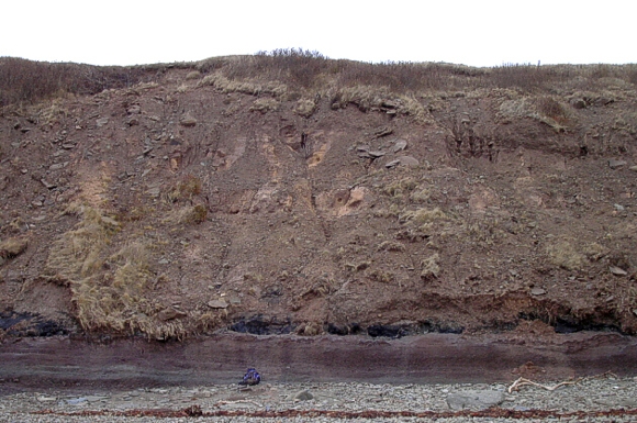
Section of Quaternary deposits north of Long Point (44/01) showing rock bench, overlying peat, sand and till deposits.
At the base of the Quaternary section is red sandstone bedrock with a planar, sloping surface above which lie two or three compressed peat layers with wood fragments. The peat layers contain large logs and can be traced laterally for 200 m, dipping seaward below the high water mark. An organic diamicton is interbedded with the peat layers. Oxidized gravelly-sand lies above these organic units and it is overlain by a parallel-laminated, well-sorted sand with minor gravel lenses up to about 13 m above MSL. Above the sand is a massive gravelly sand with angular clasts and crude horizontal bedding. These sediments are capped by a reddish-brown silty till, and 2-3 m of laminated silty sand and clay-rich diamicton.
Interpretation
The planar rock bench of red Carboniferous sandstone is similar to wave-cut platforms exposed on the eastern side of St. Georges Bay. A radiocarbon-dated peat layer is also found above a rock bench at Moose Point, on the northern shore of Chedabucto Bay. Pollen from the peat layer at Moose Point suggests a cool part of the last interglacial period (Oxygen Isotope Stage 5d or 5b). Locally-derived organic diamictons above the peat may be deposits of mass wasting. The sand unit can be traced along much of northern coast of mainland Nova Scotia and attains elevations of +25 m. The well-sorted nature of the sand, parallel lamination, and graded beds with content of well-rounded ravels suggest a marine origin, possibly shoreface or beach environments. A stratigraphy identical to the Nova Scotia sections is found in the Îles de la Madeleine, Quebec, with interglacial peat, well-sorted sand deposits containing Ostrea virginica, and an erosional rock platform at elevations of +13-+20 m (Dredge et al., 1992). Recent OSL (optically-stimulated luminescence dating) of the sand unit at Cape George, Antigonish County, gave an age of 115 ± 19 ka, putting that sand deposit within oxygen Isotope Stage 5e, the warmest part of the last interglacial. If you look carefully you can see circular sampling pits in the sand for OSL dating. Dorothy Godfrey-Smith of Dalhousie University is conducting the dating study and you can read all about optical dating methods at her web page.
These data taken together imply much higher interglacial sea levels that previously thought. The stratigraphic record also suggests an RSL oscillation with an early rise to >4 m (rock bench), RSL fall (peat layer, and then subsequent RSL rise (Cape George-Magdalen Island sands) to 20 m higher than present. This RSL record suggests the combined effects of climate change and slow forebulge collapse following the Illinoian glaciation although it is not certain that the magnitude of forebulge subsidence indicated by these high interglacial sea levels are predicted by current models.
Some useful references
- Dredge, L., Mott, R. J. and Grant, D. R.1992:
- Quaternary stratigraphy, paleoecology, and glacial geology, Iles de la Madeleine, Quebec, Canadian Journal of Earth Sciences, v. 29, p. 1981-1996.
- Grant, D. R. 1994:
- Quaternary Geology, Cape Breton Island; Geological Survey of Canada, Bulletin 482, 159 p.
- Stea, R. R., Scott, D. B., Godfrey-Smith, D. and Mott, R. J. 2002:
- Sangamon Interglacial sea-levels of +20 m in Maritime Canada; in abstracts volume 27, Geological Society of Canada-Mineralogical Society of Canada, Joint Annual Meeting, Saskatoon, p. 113.
Go back to the chopper (virtual field trip home page) or