
Stop 9: Striae on Wittenburg Mountain
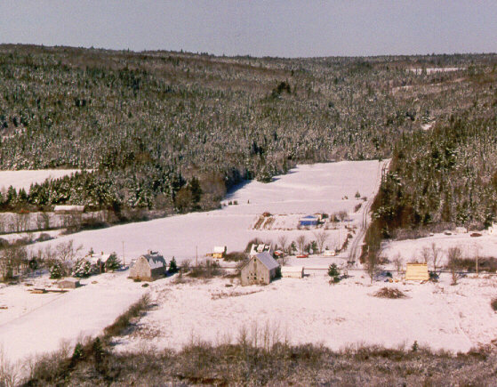
Wittenburg Mountain is a flat-topped highland attaining 200 m in elevation composed of Cambro-Ordovician slate and metagreywacke. This upland block was exhumed from beneath a cover of ate Paleozoic and Mesozoic sedimentary rocks during the Middle Cretaceous phase of regional uplift and tectonics, roughly 100 million years ago. Several generations of glacial striae are inscribed on the fine-grained slate and metawacke of this upland block, reflecting shifting ice centres and divides in eastern Canada. During this stop we will look at some of these intriguing glacial erosional features and discuss the glaciation of Wittenburg Mountain.
Summary for non-geologists: Wittenburg Mountain has many rock outcrops that are smoothed and polished by glaciers and show parallel, linear deep and wide grooves and scratches, that are aligned in the direction of glacier flow. These scratches, called striae, are formed as rock-laden ice slides across the bedrock surface like sandpaper across a fresh wood finish. Often, two or more directions of ice flow are recorded by crossing patterns of striae, indications of shifting glaciers during the last ice age. On many rock surfaces where there is not much soil cover one can see branching grooves and furrows carved into solid rock surfaces. These are thought to be traces of extensive tree root systems.
Description
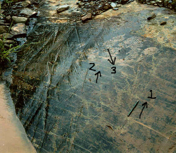
Stop 95-79 shows three directions of flow, 1-southeastward, 2-southward, 3-westward.
Glacially sculpted rock outcrops are common on Wittenburg Mountain. These outcrops are often marked by small-scale glacier erosional forms such as striae, grooves, and crescentic chatter marks (Prest, 1983). The outcrops display asymmetric profiles, with abraded, gently dipping stoss sides and steep, jagged lee slopes. A distinctive feature of glaciated outcrops on Wittenburg Mountain are several distinct "sets" of glacial striae. Open this map of striae localities on the mountain.
Many sites reveal three or four sets of glacial striae. Their relative ages were established using the following methods:
- stoss/lee preference (younger sets of striae inscribed on the fresh, stoss side of a rock outcrop, with older, degraded striae preserved on the weathered lee side);
- "higher ground" criterion (finer striae (younger) inscribed on the up-glacier facing slopes and intervening highs between older grooves. The youngest striation directions are generally best developed on the uppermost portions of the outcrop. The photo above shows older, southeastward-trending grooves (parallel to the pencil) cut by later, southwestward striae;
- striae (younger) inscribed on erosional mini crag-and-tail ridges of the older ice flow.
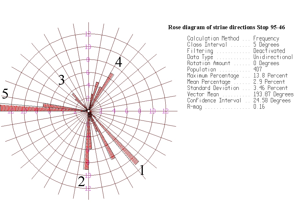
At site 95-46, 400 measurements were made of individual striae and plotted on a rose diagram to demonstrate the continuity and coherence of striation sets.
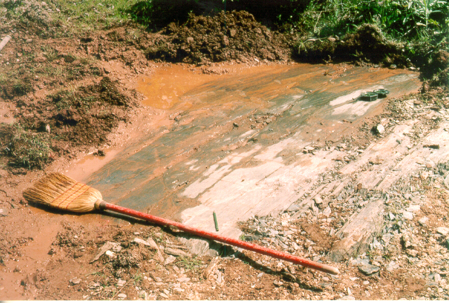
Stop 94-18 is the most readily accessible striation site, located along a dirt side road near Middle Musquodoboit. This site reveals three of the four regional striation patterns, an early ice flow to the southeast (broom) followed by a flow to the north (pencil), and finally by a flow to the west (compass).
Unusual erosional scours were found on many outcrops on Wittenburg Mountain, generally restricted to areas without till cover. These scours could be as deep as a couple of centimetres and several centimetres across forming complex branching patterns. A reticulate pattern was observed within some of the scours. I interpret these erosional features as root traces, developed by chemical etching of rock.
Interpretation
Development of a chronology of ice flows by examination of the crosscutting relationships of glacial striae has been termed "EROSIONAL STRATIGRAPHY". Shifting ice centres over Nova Scotia during the last ice age scoured the mountain from differing directions. The preservation of striae formed by glaciers coming from different directions depends on the orientation of the outcrop and, at a larger scale, the orientation of the mountain itself. Striae are preserved if the rock outcrop or hill is sloping towards the ice flow. If the "facing direction" of the outcrop or hill is down-flow, there is less likelihood that the striae relating to that event will be preserved. On the map the northeastward flow event (Scotian Phase-Phase 3) is preserved only on the south-sloping side of Wittenburg Mountain.
Based largely on erosional stratigraphy, a model of glaciations has been constructed for Atlantic Canada and cartoons of the changing glaciers can be seen in the reading room.
Some Useful References
- Prest, V. K. 1983:
- Canada's heritage of glacial features; Geological Survey of Canada, Miscellaneous Report 28, 89 p.
- Stea, R. R.1994:
- Relict and palimpsest glacial landforms in Nova Scotia, Canada; in W. P. Warren and D. G. Groot, eds., Formation and Deformation of Glacial Deposits; Balkema, Rotterdam, p. 141-158.
- Stea, R. R.1998:
- Surficial geology of the Shubenacadie area [11E/03], Colchester, Halifax and Hants Counties, Nova Scotia: Nova Scotia Department of Natural Resources, Open File Map ME 1998-3, Scale: 1:50 000.
Go back to the chopper (virtual field trip home page) or