
Geological Survey Division Publications - Hydrogeology Program
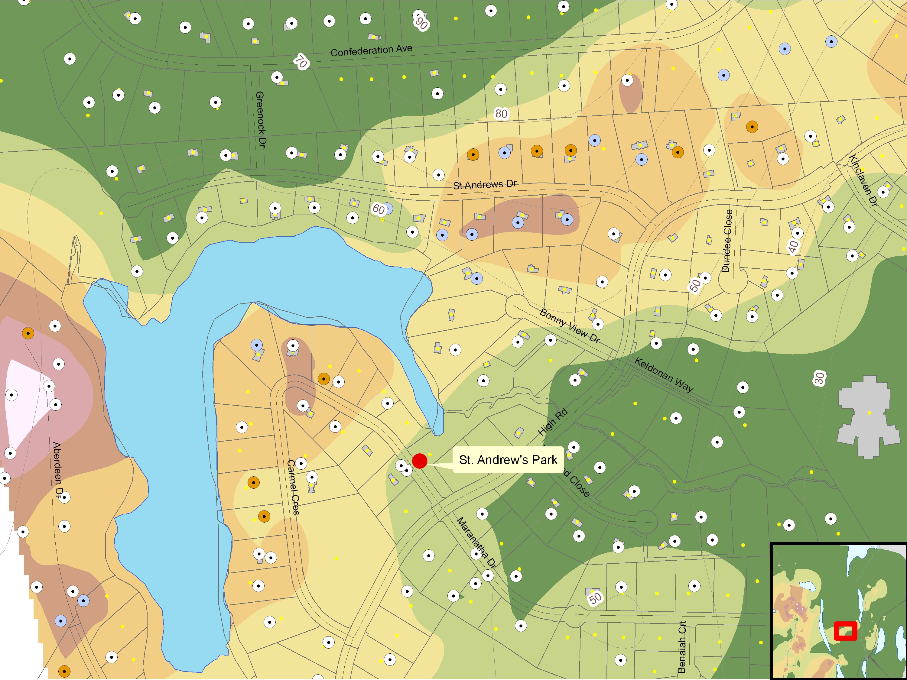
A Manganese in Well Water Risk Map for Nova Scotia
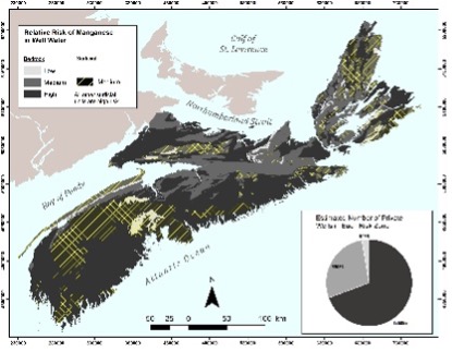
A risk (hazard) map was developed for manganese in Nova Scotia's domestic well water supplies based on available well-water chemistry data and geology mapping. Long-term exposure to elevated manganese in well water is associated with impaired brain function in children and impaired memory, attention, and movement in adults. The risk map will be used to communicate the risk of manganese in private well drinking water, and to encourage routine water testing and appropriate treatment which will lead to improved public health outcomes.
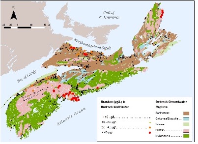
A Uranium in Well Water Risk Map for Nova Scotia Based on Observed Uranium Concentrations in Bedrock Aquifers
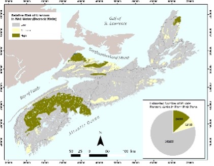
The distribution of uranium in the province’s well water compared to available bedrock geology mapping was investigated to further advance the understanding of the relationship between uranium occurrence in well water and various bedrock units, and to develop a new risk map to communicate the risk of uranium exposure to well owners. Long-term exposure to elevated uranium in well water is associated with kidney damage. The risk map will be used to communicate the risk of uranium in private well drinking water, and to encourage routine water testing and appropriate treatment which will lead to improved public health outcomes.
A Review of Private Well Contaminants, Testing, and Mitigation Behaviours in Nova Scotia
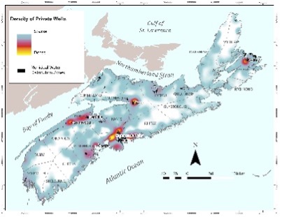
Information was compiled on various private domestic well contaminants and private well stewardship behaviours in the province. Based on the available evidence, it is estimated that over one third of private wells in Nova Scotia have a health-based exceedance of one or more chemical contaminants in their untreated water and that about 25 to 40% of private wells may have total coliform in their drinking water. The analysis also demonstrated that there is poor adherence to the province’s recommended frequency for water testing due to multiple barriers.
Potential Corrosivity of Groundwater in Nova Scotia and its Association with Lead in Private Well Water
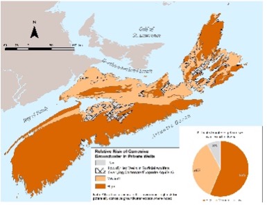
The potential corrosivity of groundwater was characterized for seven major aquifer types across Nova Scotia using available groundwater chemistry data, and the chloride-to-sulphate mass ratio and Langelier Saturation indices, to identify areas where there may be a greater likelihood of lead in private well water supplies. Exposure to lead in well water supplies is associated with a range of adverse health effects, including impaired neurological function. A relative risk map was produced showing the potential corrosivity of groundwater in Nova Scotia. The risk map will be used to communicate the risk of lead and other metals leaching from plumbing materials, and to encourage routine water testing and appropriate treatment, which will lead to improved public health outcomes.
A Review and Summary of Activities Related to Uranium in Nova Scotia Well Water
Historical research and well water surveys related to uranium in Nova Scotia well water was reviewed and summarized. The review compiled historical datasets and found that bedrock geology was the dominant control on uranium concentrations in water wells.
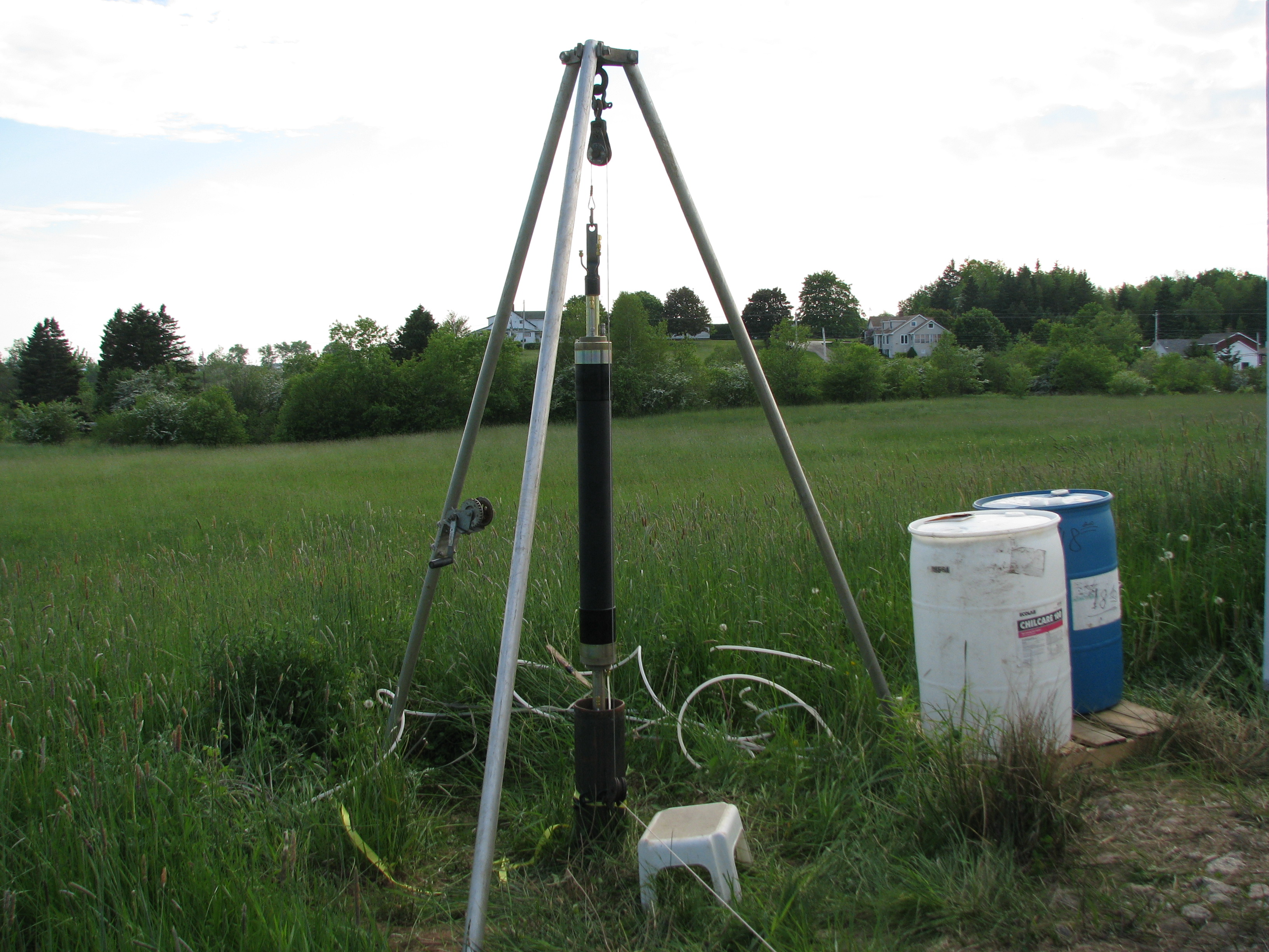
Instructions for Building a Real-Time Well Water Level Meter
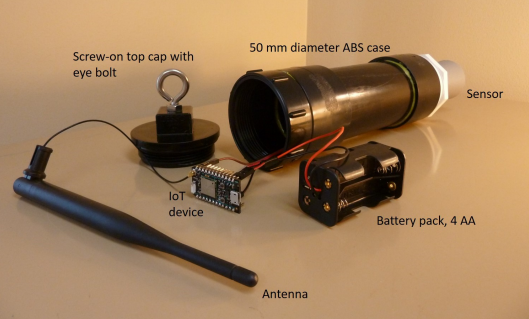
This report provides instructions for building a low-cost, real-time water level meter for use in dug wells. The meter is designed to hang inside a dug well, measure the water level once a day, and send the data by WiFi to a webpage for immediate viewing and downloading. The cost for the parts to build the meter is approximately Can$200.
Where Does Our Tap Water Come From? An Analysis of Domestic Water Source and Supply Demographics in Nova Scotia
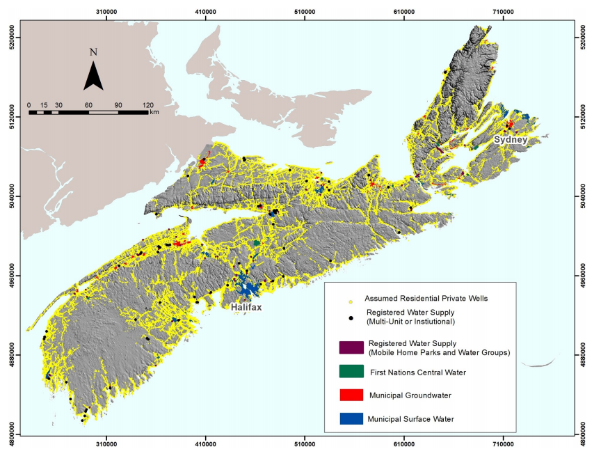
To better understand and monitor where Nova Scotians obtain their domestic water, a methodology was developed for estimating domestic water source (e.g. groundwater or surface water) and supply types (e.g. public water system or private water supply) using existing data and simple geoprocessing techniques.
Development of indices to assess the potential impact of drought to private wells in Nova Scotia
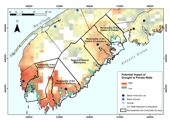
In the summer and fall of 2016, southwestern Nova Scotia experienced moderate to severe drought conditions, with rainfall deficits persisting into the winter months. Available provincial observation wells in southwestern NS showed historical lows or below normal water levels. It is estimated that over 1000 private well users in southwestern NS experienced water shortages because of the drought, especially well users relying on dug wells for domestic water supply. The NS Department of Natural Resources developed an index map to show areas of the province where private well owners are more likely to experience water shortages and published the map as a web application for planning and risk communication purposes.
An Arsenic in Well Water Risk Map for Nova Scotia based on Observed Patterns of Well Water Concentrations of Arsenic in Bedrock Aquifers
The distribution of arsenic in the province’s well water compared to available bedrock geology mapping was investigated to further advance the understanding of the relationship between arsenic occurrence in well water and various bedrock units, and to develop a new risk map to communicate the risk of arsenic exposure to well owners.
A Review of Activities Related to the Occurrence of Arsenic in Nova Scotia Well Water
... Arsenic is now considered the most prevalent naturally occurring groundwater contaminant in the province, and research over the past four decades has indicated that bedrock geology is the most important control on arsenic concentrations in well water in Nova Scotia ...
Baseline Hydrological Monitoring at Big Meadow Bog
The NS Department of Natural Resources assisted with the baseline hydrological characterization of Big Meadow Bog on Brier Island, Digby County. The objective of the work was to characterize the hydrologic change and baseline conditions of the bog towards the proposed evaluation of options to stabilize or restore the peatland, and limit the threat of habitat degradation for eastern mountains avens, a globally rare plant.
Groundwater Resources of Sable Island
The freshwater resources of Sable Island were first assessed in the 1970s due to increasing interest in oil exploration and the concomitant need for potable water and sound management of the island’s water resources. Assessment activities included test drilling, water-level monitoring, groundwater and surface-water sampling for chemical and bacteriological quality, pumping tests, and a geophysical survey. The findings and recommendations were released as an assessment report, which serves as a baseline understanding of freshwater resources on the island (Hennigar, 1976).
Identification and Preliminary Mapping of Surficial Aquifers in Nova Scotia
Surficial deposits of sand and gravel with sufficient saturated thickness and extent typically constitute excellent sources of groundwater with respect to both quality and quantity. Over the past 40 years, many of Nova Scotia’s surficial aquifers have been mapped and assessed at varying scales in local to regional groundwater exploration/assessment reports (see Nova Scotia Environment, 2013a).
Methane in Well Water in Nova Scotia
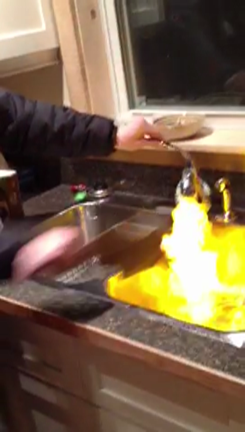
Methane is a naturally occurring hydrocarbon gas that is colourless, odourless and tasteless. It commonly occurs in groundwater at low levels that pose no health or safety risk. However, when methane is present at high concentrations it can cause flammable and explosive conditions. Although it is not considered to be a widespread problem in Nova Scotia, its presence is occasionally reported by well owners and well drillers throughout the province. In 2013, NSNR&R carried out a methane survey in the on-shore sedimentary basin areas of Nova Scotia. Approximately 100 water wells were tested for methane, and additional sampling was completed at selected wells for ethane, propane, and hydrogen and carbon isotopes. The results of the survey were used to create a map of methane in groundwater, and to determine whether the methane originated from biogenic or thermogenic sources.
Occurrence and Mobilization of Uranium in Groundwater in Nova Scotia
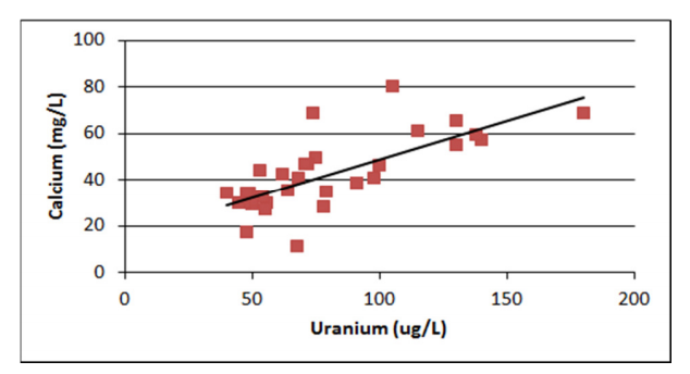
This study looked at the association between calcium and uranium using the provincial groundwater chemistry database and aqueous speciation modelling. The results showed strong positive correlations between uranium, calcium and chloride. Speciation modelling indicated that calcium can be an important influence on the mobility of uranium in groundwater in Nova Scotia due to the formation of zero-valent calcium-uranyl-carbonate complex. The results also indicate that adding salt to groundwater (i.e., by road salt or seawater intrusion) can have a similar effect on uranium mobilization, either by directly adding small amounts of calcium, or releasing calcium by ion exchange.
Seawater Intrusion Vulnerability in Nova Scotia
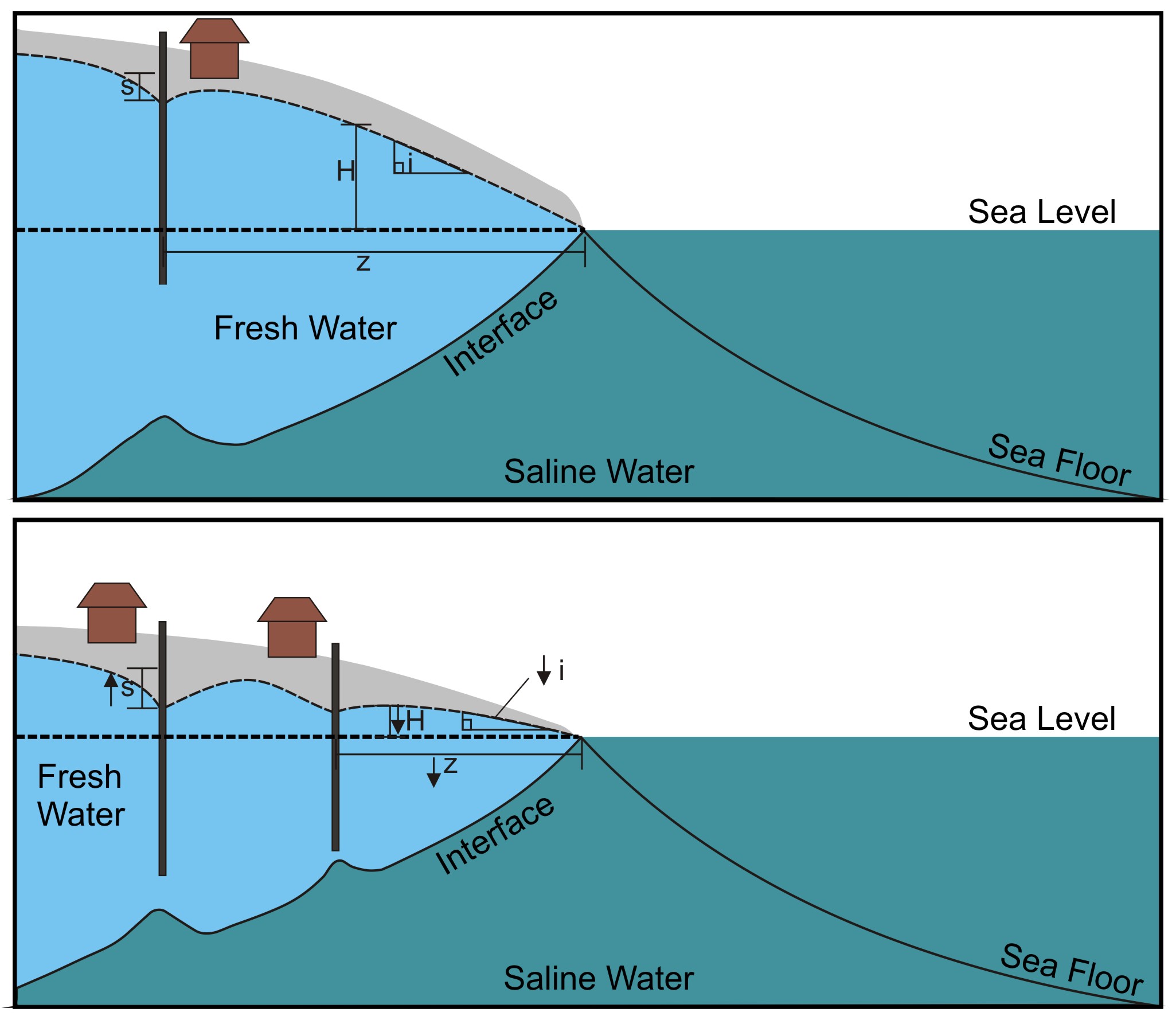
Approximately 70% of Nova Scotians reside within 20 km of the coastline and many of the province's coastal regions are experiencing residential growth. In coastal regions of the province where municipal water service is not available (unserviced areas), private wells represent the only practical means of obtaining a water supply. It is estimated that over 90% of these wells intercept fractured bedrock aquifers. There are limited tools available, however, to groundwater managers and land-use planners for evaluating the sustainability of groundwater supplies in these unserviced areas, which are vulnerable to the effects of seawater intrusion. Seawater intrusion into coastal aquifers, driven by overpumping and rising sea levels, is therefore a key issue for water resource management in Nova Scotia.
Identification of Surficial Aquifers in Halifax Regional Municipality
The fractured bedrock aquifers supplying the greater Halifax area have limited water supply capacity and are experiencing groundwater stress due to residential growth. Recent surficial geology mapping and analysis of water well data were used to locate buried fluvial material in structurally controlled bedrock topographic lows. High-potential surficial aquifer areas were highlighted, and test drilling was conducted in three of these areas. Based on the findings of the mapping and field work, a conceptual understanding of the distribution of surficial aquifer materials in key residential growth areas of Halifax is presented.
Uranium in the Town of Bridgetown Production Wells
The Town of Bridgetown overlies one of Nova Scotia's most productive sedimentary bedrock aquifers. As an alternative to the expensive upgrades required to the existing surface water system, the town initiated a groundwater exploration program in 2006 that involved the installation of three open-hole test wells and a series of pumping tests and inorganic chemistry analyses. Total uranium was found to be elevated but within acceptable concentrations. Two of the test wells were converted into partially screened larger diameter production wells in 2007. The new production wells showed higher concentrations of uranium during pump testing. To investigate the mechanism for the increase in uranium in the production wells compared to the test wells a series of investigations followed, including additional pumping tests, depth-discrete sampling, a packer test, and aqueous leachate testing of rock cuttings from the remaining test well.
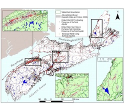
Preliminary Regional Groundwater Budgets in Nova Scotia
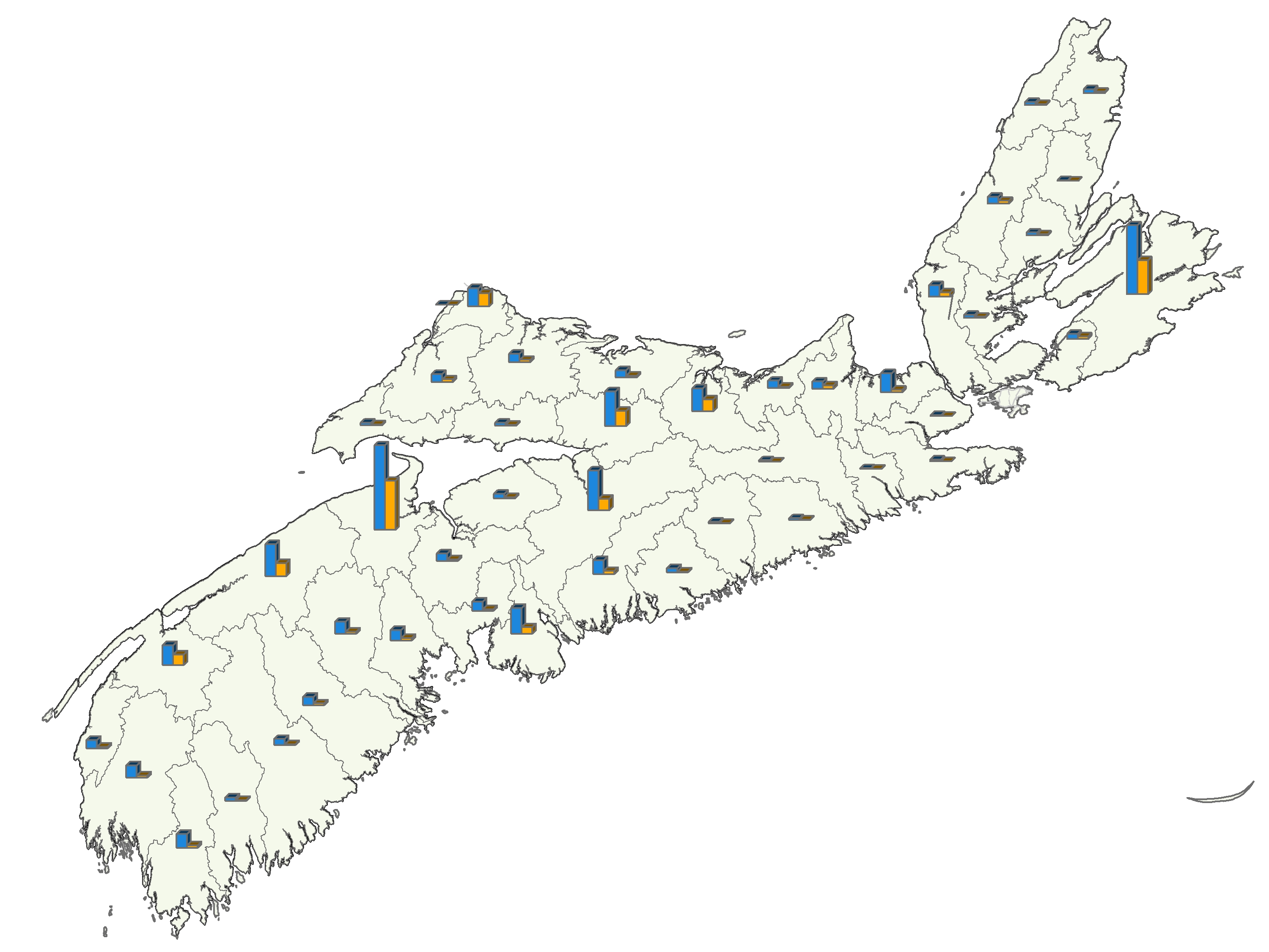
Regional groundwater budgets were estimated for 44 major groundwatersheds across Nova Scotia. Groundwater availability was estimated using a GIS processing model with precipitation and bedrock groundwater recharge ratio inputs derived from available climate and streamflow data. Municipal wells and residential and non-residential unserviced groundwater users were plotted, and total groundwater use in each major groundwatershed was estimated using the best available information.
Characterization of Nova Scotia’s Major Groundwater Regions
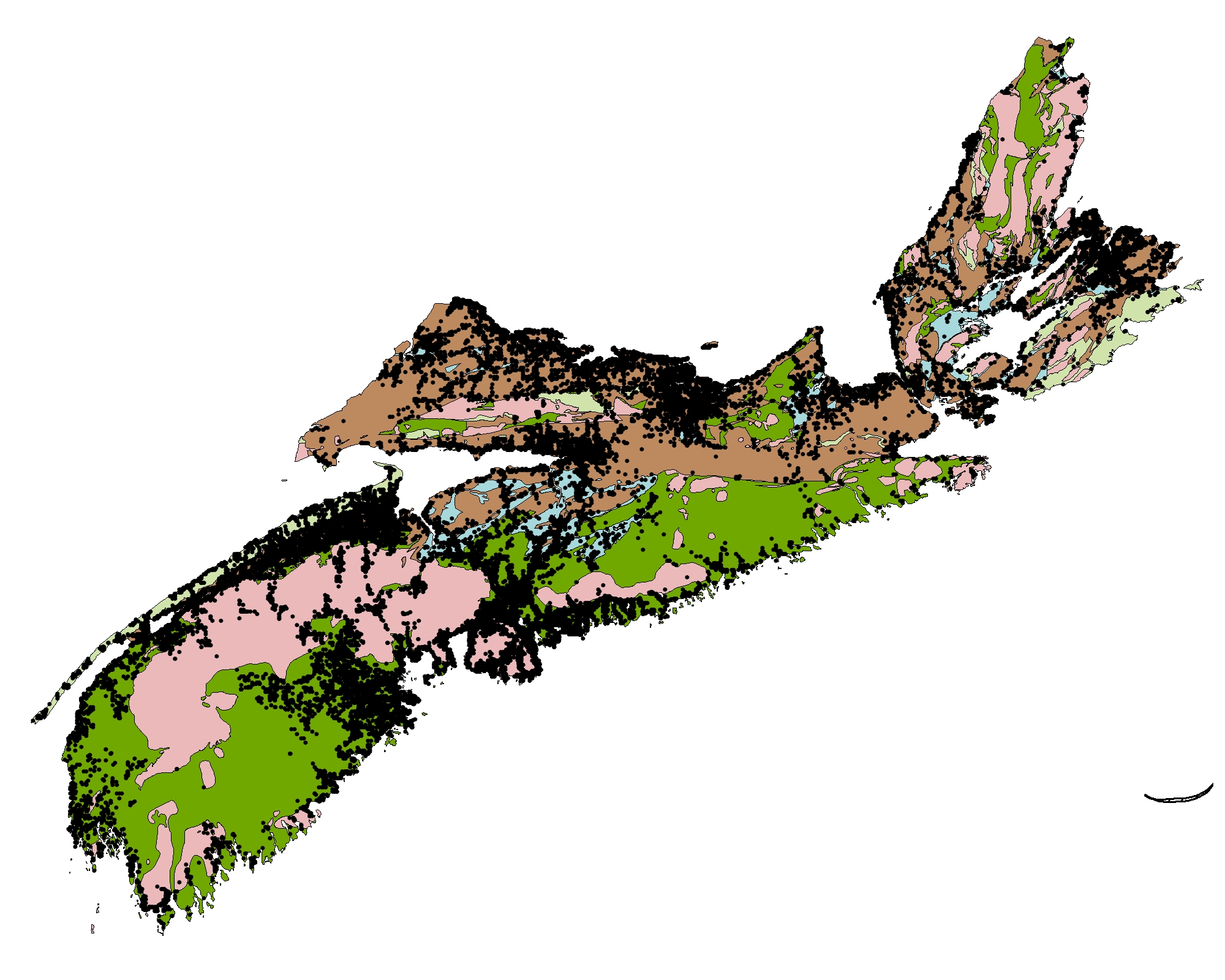
Nova Scotia's aquifers have been broadly divided into five bedrock and five surficial groundwater regions based on existing maps of the dominant bedrock types and sediment deposits. Hydrogeologic characterization of the groundwater regions was carried out by classifying over 70,000 water well records, over 900 pumping test records and over 1000 inorganic groundwater chemistry records into the major groundwater regions, and conducting statistical analyses for various hydrogeologic properties. The statistical summaries provide a general guide to expected hydrogeological properties, and the maps and associated databases developed during this study provide a useful framework for more detailed assessment activities.